

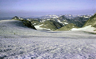
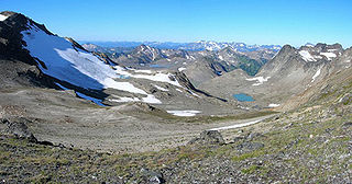
Retreat of glaciers since 1850
Encyclopedia
Greenhouse gas
A greenhouse gas is a gas in an atmosphere that absorbs and emits radiation within the thermal infrared range. This process is the fundamental cause of the greenhouse effect. The primary greenhouse gases in the Earth's atmosphere are water vapor, carbon dioxide, methane, nitrous oxide, and ozone...
es is often cited as an evidentiary underpinning of global warming
Global warming
Global warming refers to the rising average temperature of Earth's atmosphere and oceans and its projected continuation. In the last 100 years, Earth's average surface temperature increased by about with about two thirds of the increase occurring over just the last three decades...
. Mid-latitude mountain ranges such as the Himalayas
Himalayas
The Himalaya Range or Himalaya Mountains Sanskrit: Devanagari: हिमालय, literally "abode of snow"), usually called the Himalayas or Himalaya for short, is a mountain range in Asia, separating the Indian subcontinent from the Tibetan Plateau...
, Alps
Alps
The Alps is one of the great mountain range systems of Europe, stretching from Austria and Slovenia in the east through Italy, Switzerland, Liechtenstein and Germany to France in the west....
, Rocky Mountains
Rocky Mountains
The Rocky Mountains are a major mountain range in western North America. The Rocky Mountains stretch more than from the northernmost part of British Columbia, in western Canada, to New Mexico, in the southwestern United States...
, Cascade Range
Cascade Range
The Cascade Range is a major mountain range of western North America, extending from southern British Columbia through Washington and Oregon to Northern California. It includes both non-volcanic mountains, such as the North Cascades, and the notable volcanoes known as the High Cascades...
, and the southern Andes
Andes
The Andes is the world's longest continental mountain range. It is a continual range of highlands along the western coast of South America. This range is about long, about to wide , and of an average height of about .Along its length, the Andes is split into several ranges, which are separated...
, as well as isolated tropical summits such as Mount Kilimanjaro
Mount Kilimanjaro
Kilimanjaro, with its three volcanic cones, Kibo, Mawenzi, and Shira, is a dormant volcano in Kilimanjaro National Park, Tanzania and the highest mountain in Africa at above sea level .-Geology:...
in Africa, are showing some of the largest proportionate glacial losses.
The Little Ice Age
Little Ice Age
The Little Ice Age was a period of cooling that occurred after the Medieval Warm Period . While not a true ice age, the term was introduced into the scientific literature by François E. Matthes in 1939...
was a period from about 1550 to 1850 when the world experienced relatively cooler temperatures compared to the present. Subsequently, until about 1940, glaciers around the world retreated as the climate warmed substantially. Glacial retreat slowed and even reversed temporarily, in many cases, between 1950 and 1980 as a slight global cooling
Global cooling
Global cooling was a conjecture during the 1970s of imminent cooling of the Earth's surface and atmosphere along with a posited commencement of glaciation...
occurred. Since 1980, a significant global warming
Global warming
Global warming refers to the rising average temperature of Earth's atmosphere and oceans and its projected continuation. In the last 100 years, Earth's average surface temperature increased by about with about two thirds of the increase occurring over just the last three decades...
has led to glacier retreat becoming increasingly rapid and ubiquitous, so much so that some glaciers have disappeared altogether, and the existence of a great number of the remaining glaciers of the world is threatened. In locations such as the Andes of South America and Himalayas in Asia, the demise of glaciers in these regions will have potential impact on water supplies. The retreat of mountain glaciers, notably in western North America, Asia, the Alps, Indonesia
Indonesia
Indonesia , officially the Republic of Indonesia , is a country in Southeast Asia and Oceania. Indonesia is an archipelago comprising approximately 13,000 islands. It has 33 provinces with over 238 million people, and is the world's fourth most populous country. Indonesia is a republic, with an...
and Africa, and tropical and subtropical regions of South America, has been used to provide qualitative evidence for the rise in global temperatures since the late 19th century. The recent substantial retreat and an acceleration of the rate of retreat since 1995 of a number of key outlet glaciers of the Greenland
Greenland ice sheet
The Greenland ice sheet is a vast body of ice covering , roughly 80% of the surface of Greenland. It is the second largest ice body in the world, after the Antarctic Ice Sheet. The ice sheet is almost long in a north-south direction, and its greatest width is at a latitude of 77°N, near its...
and West Antarctic
West Antarctic Ice Sheet
The West Antarctic Ice Sheet is the segment of the continental ice sheet that covers West Antarctica, the portion of Antarctica on the side of the Transantarctic Mountains which lies in the Western Hemisphere. The WAIS is classified as a marine-based ice sheet, meaning that its bed lies well...
ice sheet
Ice sheet
An ice sheet is a mass of glacier ice that covers surrounding terrain and is greater than 50,000 km² , thus also known as continental glacier...
s, may foreshadow a rise in sea level, having a potentially dramatic effect on coastal regions worldwide.
Glacier mass balance
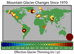
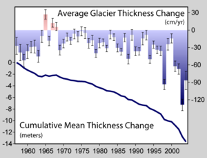
Crucial to the survival of a glacier is its mass balance, the difference between accumulation
Glacier ice accumulation
Glacier ice accumulation occurs through accumulation of snow and other frozen precipitation, as well as through other means including rime ice , avalanching from hanging glaciers on cliffs and mountainsides above, and re-freezing of glacier meltwater as superimposed ice...
and ablation (melting and sublimation). Climate change
Climate change
Climate change is a significant and lasting change in the statistical distribution of weather patterns over periods ranging from decades to millions of years. It may be a change in average weather conditions or the distribution of events around that average...
may cause variations in both temperature and snowfall, causing changes in mass balance. A glacier with a sustained negative balance is out of equilibrium and will retreat. A glacier with sustained positive balance is also out of equilibrium, and will advance to reestablish equilibrium. Currently, there are a few advancing glaciers, although their modest growth rates suggest that they are not far from equilibrium.
Glacier retreat results in the loss of the low-elevation region of the glacier. Since higher elevations are cooler, the disappearance of the lowest portion of the glacier reduces overall ablation, thereby increasing mass balance and potentially reestablishing equilibrium. If the mass balance of a significant portion of the accumulation zone of the glacier is negative, it is in disequilibrium with the climate and will melt away without a colder climate and or an increase in frozen precipitation.
The key symptom of a glacier in disequilibrium is thinning along the entire length of the glacier. This indicates thinning in the accumulation zone. The result is marginal recession of the accumulation zone margin, not just of the terminus. In effect, the glacier no longer has a consistent accumulation zone and without an accumulation zone cannot survive. For example, Easton Glacier will likely shrink to half its size, but at a slowing rate of reduction, and stabilize at that size, despite the warmer temperature, over a few decades. However, the Grinnell Glacier will shrink at an increasing rate until it disappears. The difference is that the upper section of Easton Glacier remains healthy and snow covered, while even the upper section of the Grinnell Glacier is bare, is melting and has thinned. Small glaciers with minimal altitude range are most likely to fall into disequilibrium with the climate.
Methods for measuring glacier retreat include staking terminus location
Glacier terminus
A glacier terminus, or snout, is the end of a glacier at any given point in time. Although glaciers seem motionless to the observer, in reality glaciers are in endless motion and the glacier terminus is always either advancing or retreating...
, global positioning mapping, aerial mapping, and laser altimetry.
Mid-latitude glaciers
Mid-latitude glaciers are located either between the Tropic of Cancer and the Arctic CircleArctic Circle
The Arctic Circle is one of the five major circles of latitude that mark maps of the Earth. For Epoch 2011, it is the parallel of latitude that runs north of the Equator....
, or between the Tropic of Capricorn and the Antarctic Circle
Antarctic Circle
The Antarctic Circle is one of the five major circles of latitude that mark maps of the Earth. For 2011, it is the parallel of latitude that runs south of the Equator.-Description:...
. These two regions support glacier ice from mountain glaciers, valley glaciers and even smaller icecaps, which are usually located in higher mountainous regions. All of these glaciers are located in mountain ranges, notably the Himalayas
Himalayas
The Himalaya Range or Himalaya Mountains Sanskrit: Devanagari: हिमालय, literally "abode of snow"), usually called the Himalayas or Himalaya for short, is a mountain range in Asia, separating the Indian subcontinent from the Tibetan Plateau...
; the Alps
Alps
The Alps is one of the great mountain range systems of Europe, stretching from Austria and Slovenia in the east through Italy, Switzerland, Liechtenstein and Germany to France in the west....
; the Pyrenees
Pyrenees
The Pyrenees is a range of mountains in southwest Europe that forms a natural border between France and Spain...
; Rocky Mountains
Rocky Mountains
The Rocky Mountains are a major mountain range in western North America. The Rocky Mountains stretch more than from the northernmost part of British Columbia, in western Canada, to New Mexico, in the southwestern United States...
and Pacific Coast Ranges of North America; the Patagonia
Patagonia
Patagonia is a region located in Argentina and Chile, integrating the southernmost section of the Andes mountains to the southwest towards the Pacific ocean and from the east of the cordillera to the valleys it follows south through Colorado River towards Carmen de Patagones in the Atlantic Ocean...
n Andes in South America; and mountain ranges in New Zealand. Glaciers in these latitudes are more widespread and tend to be greater in mass the closer they are located to the polar regions. These glaciers are the most widely studied over the past 150 years. As is true with the glaciers located in the tropical zone, virtually all the glaciers in the mid-latitudes are in a state of negative mass balance and are retreating.
Eastern hemisphere
Europe
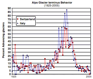
The World Glacier Monitoring ServiceWorld Glacier Monitoring Service
The World Glacier Monitoring Service was started in 1986, combining the two former services PSFG and TTS/WGI ....
reports on changes in the terminus, or lower elevation end, of glaciers from around the world every five years. In the World Glacier Monitoring Service's 2000–2005 edition, they noted the terminal point variations of glaciers across the Alps. Over the five-year period from 2000–2005, 115 of 115 glaciers examined in Switzerland
Switzerland
Switzerland name of one of the Swiss cantons. ; ; ; or ), in its full name the Swiss Confederation , is a federal republic consisting of 26 cantons, with Bern as the seat of the federal authorities. The country is situated in Western Europe,Or Central Europe depending on the definition....
retreated, 115 of 115 glaciers in Austria
Austria
Austria , officially the Republic of Austria , is a landlocked country of roughly 8.4 million people in Central Europe. It is bordered by the Czech Republic and Germany to the north, Slovakia and Hungary to the east, Slovenia and Italy to the south, and Switzerland and Liechtenstein to the...
retreated. In Italy during 50 glaciers were retreating and 3 stationary, and all 7 glaciers observed in France were in retreat. French glaciers experienced a sharp retreat in the years 1942–53 followed by advances up to 1980, and then further retreat beginning in 1982. As an example, since 1870 the Argentière Glacier and Mont Blanc
Mont Blanc
Mont Blanc or Monte Bianco , meaning "White Mountain", is the highest mountain in the Alps, Western Europe and the European Union. It rises above sea level and is ranked 11th in the world in topographic prominence...
Glacier have receded by 1150 m (3,773 ft) and 1400 m (4,593.2 ft), respectively. The largest glacier in France, the Mer de Glace
Mer de Glace
The Mer de Glace is a glacier located on the northern slopes of the Mont Blanc massif, in the Alps. At long and deep, it is the longest glacier in France.-Geography:...
, which is 11 km (6.8 mi) long and 400 m (1,312.3 ft) thick, has lost 8.3% of its length, or 1 km (0.621372736649807 mi), in 130 years, and thinned by 27%, or 150 m (492.1 ft), in the midsection of the glacier since 1907. The Bossons Glacier in Chamonix
Chamonix
Chamonix-Mont-Blanc or, more commonly, Chamonix is a commune in the Haute-Savoie département in the Rhône-Alpes region in south-eastern France. It was the site of the 1924 Winter Olympics, the first Winter Olympics...
, France, has retreated 1200 m (3,937 ft) from extents observed in the early 20th century. In 2010, of 95 Swiss glaciers studied, 86 retreated from where their terminal points had been in 2009, 6 showed no change and 3 advanced.
Other researchers have found that glaciers across the Alps appear to be retreating at a faster rate than a few decades ago. In 2008, the Swiss Glacier survey of 85 glaciers found 78 retreating, 2 stationary and 5 advancing. The Trift Glacier had retreated over 500 m (1,640.4 ft) just in the three years of 2003 to 2005, which is 10% of its total length. The Grosser Aletsch Glacier
Aletsch Glacier
The Aletsch Glacier or Great Aletsch Glacier is the largest glacier in the Alps. It has a length of about and covers more than in the eastern Bernese Alps in the Swiss canton of Valais...
, the largest glacier in Switzerland, has retreated 2600 m (8,530.2 ft) since 1880. This rate of retreat has also increased since 1980, with 30%, or 800 m (2,624.7 ft), of the total retreat occurring in the last 20% of the time period. Similarly, of the glaciers in the Italian Alps, only about a third were in retreat in 1980, while by 1999, 89% of these glaciers were retreating. In 2005, the Italian Glacier Commission found that 123 glaciers were retreating, 1 advancing and 6 stationary. Repeat photography of glaciers in the Alps provides clear evidence that glaciers in this region have retreated significantly since 1980. The Morteratsch Glacier
Morteratsch Glacier
The Morteratsch Glacier is the largest glacier by area in the Bernina Range of the Bündner Alps in Switzerland....
, Switzerland is one key example and yearly measurements of the length changes commenced in 1878. The overall retreat from 1878 to 1998 has been 2 km (1.2 mi) with a mean annual retreat rate of approximately 17 m (55.8 ft) per year. This long-term average was markedly surpassed in recent years with the glacier receding 30 m (98.4 ft) per year during the period between 1999–2005.
One major concern which has in the past had great impact on lives and property is the death and destruction from a Glacial Lake Outburst Flood
Glacial lake outburst flood
A glacial lake outburst flood is a type of outburst flood that occurs when the dam containing a glacial lake fails. The dam can consist of glacier ice or a terminal moraine...
(GLOF). Glaciers stockpile rock and soil that has been carved from mountainsides at their terminal end. These debris piles often form dams that impound water behind them and form glacial lakes as the glaciers melt and retreat from their maximum extents. These terminal moraine
Terminal moraine
A terminal moraine, also called end moraine, is a moraine that forms at the end of the glacier called the snout.Terminal moraines mark the maximum advance of the glacier. An end moraine is at the present boundary of the glacier....
s are frequently unstable and have been known to burst if overfilled or displaced by earthquakes, landslides or avalanches. If a glacier has a rapid melting cycle during warmer months, the terminal moraine may not be strong enough to hold the rising water behind it, leading to a massive localized flood. This is an increasing risk due to the creation and expansion of glacial lakes resulting from glacier retreat. Past floods have been deadly and have resulted in enormous property damage. Towns and villages in steep, narrow valleys that are downstream from glacial lakes are at the greatest risk. In 1892 a GLOF released some 200000 km³ (261,590,123,857,404 cu yd) of water from the lake of the Glacier de Tête Rousse, resulting in the deaths of 200 people in the French town of Saint Gervais. GLOFs have been known to occur in every region of the world where glaciers are located. Continued glacier retreat is expected to create and expand glacial lakes, increasing the danger of future GLOFs.
Though the glaciers of the Alps have received more attention from glaciologists than in other areas of Europe, research indicates that throughout most of Europe, glaciers are rapidly retreating. In the Kebnekaise Mountains of northern Sweden
Sweden
Sweden , officially the Kingdom of Sweden , is a Nordic country on the Scandinavian Peninsula in Northern Europe. Sweden borders with Norway and Finland and is connected to Denmark by a bridge-tunnel across the Öresund....
, a study of 16 glaciers between 1990 and 2001 found that 14 glaciers were retreating, one was advancing and one was stable. During the 20th century, glaciers in Norway
Norway
Norway , officially the Kingdom of Norway, is a Nordic unitary constitutional monarchy whose territory comprises the western portion of the Scandinavian Peninsula, Jan Mayen, and the Arctic archipelago of Svalbard and Bouvet Island. Norway has a total area of and a population of about 4.9 million...
retreated overall with brief periods of advance around 1910, 1925 and in the 1990s. In the 1990s, 11 of 25 Norwegian glaciers observed had advanced due to several consecutive winters with above normal precipitation. However, following several consecutive years of little winter precipitation since 2000, and record warmth during the summers of 2002 and 2003, Norwegian glaciers have decreased significantly since 2000s. By 2005 only 1 of the 25 glaciers monitored in Norway was advancing, two were stationary and 22 were retreating. In 2010 27 glaciers retreated, one was stationary (less than 2 meters of change) and three advanced. The Norwegian Engabreen Glacier has retreated 185 m (607 ft) since 1999, while the Brenndalsbreen and Rembesdalsskåka glaciers have retreated 276 m (905.5 ft) and 250 m (820.2 ft), respectively, since 2000. The Briksdalsbreen glacier retreated 96 m (315 ft) in 2004 alone—the largest annual retreat recorded for this glacier since monitoring began in 1900. This figure was exceeded in 2006 with five glaciers retreating over 100 m (328.1 ft) from the fall of 2005 to the fall of 2006. Four outlets from the Jostedalsbreen ice cap, Kjenndalsbreen, Brenndalsbreen, Briksdalsbreen and Bergsetbreen had a frontal retreat of more than 100 m (328.1 ft). Gråfjellsbrea, an outlet from Folgefonna, had a retreat of almost 100 m (328.1 ft). Overall, from 1999 to 2005, Briksdalsbreen retreated 336 metres (1,102.4 ft).
In the Spanish Pyrenees
Pyrenees
The Pyrenees is a range of mountains in southwest Europe that forms a natural border between France and Spain...
, recent studies have shown important losses in extent and volume of the glaciers of the Maladeta massif during the period 1981–2005. These include a reduction in area of 35.7%, from 2.41 km² (595.5 acre) to 0.627 km² (154.9 acre), a loss in total ice volume of 0.0137 km³ (0.00328680479287873 cu mi) and an increase in the mean altitude of the glacial termini of 43.5 m (142.7 ft). For the Pyrenees as a whole 50–60% of the glaciated area has been lost since 1991. The Balaitus, Perdigurero and La Munia glaciers have disappeared in this period. Monte Perdido Glacier has shrank from 90 hectares to 40 hectares.
Siberia and the Russian Far East
SiberiaSiberia
Siberia is an extensive region constituting almost all of Northern Asia. Comprising the central and eastern portion of the Russian Federation, it was part of the Soviet Union from its beginning, as its predecessor states, the Tsardom of Russia and the Russian Empire, conquered it during the 16th...
is typically classified as a polar region, owing to the dryness of the winter climate and has glaciers only in the high Altai Mountains, Verkhoyansk Range
Verkhoyansk Range
thumb|right|The Verkhoyansk Range is the L-shaped area east of the LenaThe Verkhoyansk Range is a mountain range of eastern Siberia, spanning ca. 1000 km , across the Sakha Republic. It forms a vast arc between the Lena and Aldan rivers to the west and the Yana River to the east. It rises to ca....
, Cherskiy Range and Suntar-Khayata Range
Suntar-Khayata Range
Suntar-Khayata Range is a granite mountain range rising along border of Sakha Republic in the north with Amur Oblast and Khabarovsk Krai in the south.The highest point of the range is Mus-Khaya Mountain in Sakha Republic, 2959 m...
, plus possibly a few very small glaciers in the ranges near Lake Baikal
Lake Baikal
Lake Baikal is the world's oldest at 30 million years old and deepest lake with an average depth of 744.4 metres.Located in the south of the Russian region of Siberia, between Irkutsk Oblast to the northwest and the Buryat Republic to the southeast, it is the most voluminous freshwater lake in the...
, which have never been monitored and may have completely disappeared since 1989.
In the more maritime and generally wetter Russian Far East
Russian Far East
Russian Far East is a term that refers to the Russian part of the Far East, i.e., extreme east parts of Russia, between Lake Baikal in Eastern Siberia and the Pacific Ocean...
, Kamchatka, exposed during winter to moisture from the Aleutian Low
Aleutian low
The Aleutian Low is a semi-permanent low pressure center located near the Aleutian Islands during the winter. It is one of the main centers of action in the atmospheric circulation of the Northern Hemisphere...
, has much more extensive glaciation totaling around 2500 square kilometre. Despite generally heavy winter snowfall and cool summer temperatures, the high summer rainfall of the more southerly Kuril Islands
Kuril Islands
The Kuril Islands , in Russia's Sakhalin Oblast region, form a volcanic archipelago that stretches approximately northeast from Hokkaidō, Japan, to Kamchatka, Russia, separating the Sea of Okhotsk from the North Pacific Ocean. There are 56 islands and many more minor rocks. It consists of Greater...
and Sakhalin
Sakhalin
Sakhalin or Saghalien, is a large island in the North Pacific, lying between 45°50' and 54°24' N.It is part of Russia, and is Russia's largest island, and is administered as part of Sakhalin Oblast...
in historic times melt rates have been too high for a positive mass balance even on the highest peaks. In the Chukotskiy Peninsula small alpine glaciers are numerous, but the extent of glaciation, though larger than further west, is much smaller than in Kamchatka, totalling around 300 square kilometre.
Details on the retreat of Siberian and Russian Far East glaciers less adequate than in most other glaciated areas of the world. There are several reason for this, the principle one being that since the collapse of Communism
Communism
Communism is a social, political and economic ideology that aims at the establishment of a classless, moneyless, revolutionary and stateless socialist society structured upon common ownership of the means of production...
there has been a large reduction in the number of monitoring stations. Another factor is that in the Verkhoyansk and Cherskiy Ranges it was thought glaciers were absent before they were discovered during the 1940s, whilst in ultra-remote Kamchatka and Chukotka, although the existence of glaciers was known earlier, monitoring of their size dates back no earlier than the end of World War II. Nonetheless, available records do indicate a general retreat of all glaciers in the Altai Mountains with the exception of volcanic glaciers in Kamchatka. Sakha’s glaciers, totaling seventy square kilometers, have shrunk by around 28 percent since 1945 reaching several percent annually in some places, whilst in the Altai and Chukotkan mountains and non-volcanic areas of Kamchatka, the shrinkage is considerably larger.
Asia
Mongolia
Mongolia is a landlocked country in East and Central Asia. It is bordered by Russia to the north and China to the south, east and west. Although Mongolia does not share a border with Kazakhstan, its western-most point is only from Kazakhstan's eastern tip. Ulan Bator, the capital and largest...
, western China, Pakistan
Pakistan
Pakistan , officially the Islamic Republic of Pakistan is a sovereign state in South Asia. It has a coastline along the Arabian Sea and the Gulf of Oman in the south and is bordered by Afghanistan and Iran in the west, India in the east and China in the far northeast. In the north, Tajikistan...
, Afghanistan
Afghanistan
Afghanistan , officially the Islamic Republic of Afghanistan, is a landlocked country located in the centre of Asia, forming South Asia, Central Asia and the Middle East. With a population of about 29 million, it has an area of , making it the 42nd most populous and 41st largest nation in the world...
and India
India
India , officially the Republic of India , is a country in South Asia. It is the seventh-largest country by geographical area, the second-most populous country with over 1.2 billion people, and the most populous democracy in the world...
. As is true with other glaciers worldwide, the glaciers of Asia are experiencing a rapid decline in mass. The loss of these glaciers would have a tremendous impact on the ecosystem of the region.
In the Wakhan Corridor of Afghanistan 28 of 30 glaciers examined retreated significantly during the 1976–2003 period, the average retreat was 11 m (36.1 ft) per year. One of these glaciers, the Zemestan Glacier, has retreated 460 m (1,509.2 ft) during this period, not quite 10% of its 5.2 km (3.2 mi) length. In examining 612 glaciers in China between 1950 and 1970, 53% of the glaciers studied were retreating. After 1990, 95% of these glaciers were measured to be retreating, indicating that retreat of these glaciers was becoming more widespread. Glaciers in the Mount Everest
Mount Everest
Mount Everest is the world's highest mountain, with a peak at above sea level. It is located in the Mahalangur section of the Himalayas. The international boundary runs across the precise summit point...
region of the Himalayas are all in a state of retreat. The Rongbuk Glacier
Rongbuk Glacier
Image:Himalaya_annotated.jpg|thumb|250px|right|Rongbuk Glacier and Mount Everest as seen from the International Space Station.rect 58 14 160 49 Chomo Lonzorect 200 28 335 52 Makalurect 378 24 566 45 Mount Everestrect 188 581 920 656 Tibetan Plateau...
, draining the north side of Mount Everest into Tibet
Tibet
Tibet is a plateau region in Asia, north-east of the Himalayas. It is the traditional homeland of the Tibetan people as well as some other ethnic groups such as Monpas, Qiang, and Lhobas, and is now also inhabited by considerable numbers of Han and Hui people...
, has been retreating 20 m (65.6 ft) per year. In the Khumbu region of Nepal along the front of the main Himalaya of 15 glaciers examined from 1976–2007 all retreated significantly and the average retreat was 28 m (91.9 ft) per year. The most famous of these, the Khumbu Glacier, retreated at a rate of 18 m (59.1 ft) per year from 1976–2007. However, in the second half of the last century the glacier melt in High Asia also showed interruptions. In the Inner Himalayas slight advances took place from 1970 to 1980. In India the Gangotri Glacier
Gangotri Glacier
Gangotri Glacier is located in Uttarkashi District, Uttarakhand, India in a region bordering China. This glacier, source of the Ganges, is one of the largest in the Himalayas with an estimated volume of over 27 cubic kilometers. The glacier is about 30 kilometres long and 2 to 4 km wide...
, retreated 34 m (111.5 ft) per year between 1970 and 1996, and has averaged a loss of 30 m (98.4 ft) per year since 2000. However, the glacier is still over 30 km (18.6 mi) long. In 2005, the Tehri Dam was finished on the Bhagirathi River and it is a 2400 mW facility that began producing hydropower in 2006. The headwaters of the Bhagirathi River is the Gangotri and Khatling Glacier, Garhwal Himalaya. Gangotri Glacier has retreated 1 km in the last 30 years, and with an area of 286 square kilometres (110.4 sq mi), provides up to 190 m3/second of water volume.(Singh et al., 2006). For the Indian Himalaya, retreat averaged 19 m (62.3 ft) per year for 17 glaciers. In Sikkim 26 glaciers examined were retreating at an average rate of 13.02 m per year from 1976 to 2005. For the 51 glaciers in the main Himalayan Range of India, Nepal and Sikkim, 51 glaciers are retreating, at an average rate of 23 metres (75.5 ft) per year. In the Karokoram Range of the Himalaya there is a mix of advancing and retreating glaciers with 18 advancing and 22 retreating during the 1980–2003 period.
With the retreat of glaciers in the Himalayas, a number of glacial lakes have been created. A growing concern is the potential for Glacial Lake Outburst Floods—researchers estimate 20 glacial lakes in Nepal
Nepal
Nepal , officially the Federal Democratic Republic of Nepal, is a landlocked sovereign state located in South Asia. It is located in the Himalayas and bordered to the north by the People's Republic of China, and to the south, east, and west by the Republic of India...
and 24 in Bhutan
Glaciers of Bhutan
The glaciers of Bhutan, which covered about 10 percent of the total surface area in the 1980s, are an important renewable source of water for Bhutan's rivers. Fed by fresh snow each winter and slow melting in the summer, the glaciers bring millions of litres of fresh water to Bhutan and downriver...
pose hazards to human populations should their terminal moraines fail. One glacial lake identified as potentially hazardous is Bhutan's Raphstreng Tsho, which measured 1.6 km (0.994196378639691 mi) long, 0.96 m (0.00096 km) wide and was 80 m (262.5 ft) deep in 1986. By 1995 the lake had swollen to a length of 1.94 km (1.2 mi), 1.13 km (0.702151192414282 mi) in width and a depth of 107 m (351 ft). In 1994 a GLOF from Luggye Tsho, a glacial lake adjacent to Raphstreng Tsho, killed 23 people downstream.
Glaciers in the Ak-shirak Range in Kyrgyzstan
Kyrgyzstan
Kyrgyzstan , officially the Kyrgyz Republic is one of the world's six independent Turkic states . Located in Central Asia, landlocked and mountainous, Kyrgyzstan is bordered by Kazakhstan to the north, Uzbekistan to the west, Tajikistan to the southwest and China to the east...
experienced a slight loss between 1943 and 1977 and an accelerated loss of 20% of their remaining mass between 1977 and 2001. In the Tien Shan mountains, which Kyrgyzstan shares with China and Kazakhstan
Kazakhstan
Kazakhstan , officially the Republic of Kazakhstan, is a transcontinental country in Central Asia and Eastern Europe. Ranked as the ninth largest country in the world, it is also the world's largest landlocked country; its territory of is greater than Western Europe...
, studies in the northern areas of that mountain range show that the glaciers that help supply water to this arid region, lost nearly 2 km³ (0.479825517208573 cu mi) of ice per year between 1955 and 2000. The University of Oxford
University of Oxford
The University of Oxford is a university located in Oxford, United Kingdom. It is the second-oldest surviving university in the world and the oldest in the English-speaking world. Although its exact date of foundation is unclear, there is evidence of teaching as far back as 1096...
study also reported that an average of 1.28% of the volume of these glaciers had been lost per year between 1974 and 1990.
The Pamirs mountain range located primarily in Tajikistan
Tajikistan
Tajikistan , officially the Republic of Tajikistan , is a mountainous landlocked country in Central Asia. Afghanistan borders it to the south, Uzbekistan to the west, Kyrgyzstan to the north, and China to the east....
, has many thousands of glaciers, all of which are in a general state of retreat. During the 20th century, the glaciers of Tajikistan lost 20 km³ (4.8 cu mi) of ice. The 70 km (43.5 mi) long Fedchenko Glacier
Fedchenko Glacier
The Fedchenko Glacier is a large glacier in the Pamir Mountains of north-central Gorno-Badakhshan province, Tajikistan. The glacier is long and narrow, currently extending for and covering over . It is the longest glacier in the world outside of the polar regions...
, which is the largest in Tajikistan and the largest non-polar glacier on Earth, lost 1.4% of its length, or 1 km (0.621372736649807 mi), 2 km³ (0.479825517208573 cu mi) of its mass, and the glaciated area was reduced by 11 km² (4.2 sq mi) during the 20th century. Similarly, the neighboring Skogatch Glacier lost 8% of its total mass between 1969 and 1986. The country of Tajikistan and neighboring countries of the Pamir Range are highly dependent upon glacial runoff to ensure river flow during droughts and the dry seasons experienced every year. The continued demise of glacier ice will result in a short-term increase, followed by a long-term decrease in glacial melt water flowing into rivers and streams.
The Tibetan Plateau
Tibetan Plateau
The Tibetan Plateau , also known as the Qinghai–Tibetan Plateau is a vast, elevated plateau in Central Asia covering most of the Tibet Autonomous Region and Qinghai, in addition to smaller portions of western Sichuan, southwestern Gansu, and northern Yunnan in Western China and Ladakh in...
contains the world's third-largest store of ice. Qin Dahe, the former head of the China Meteorological Administration
China Meteorological Administration
The China Meteorological Administration , headquartered in Beijing, is the national weather service for the People's Republic of China.-History:...
, said that the recent fast pace of melting and warmer temperatures will be good for agriculture and tourism in the short term; but issued a strong warning:
Temperatures are rising four times faster than elsewhere in China, and the Tibetan glaciers are retreating at a higher speed than in any other part of the world ... In the short term, this will cause lakes to expand and bring floods and mudflows ... In the long run, the glaciers are vital lifelines for Asian rivers, including the Indus and the Ganges. Once they vanish, water supplies in those regions will be in peril.
Oceania
Tasman Glacier
The Tasman Glacier is the largest of several glaciers which flow south and east towards the Mackenzie Basin from the Southern Alps in New Zealand's South Island. It is New Zealand's longest glacier.-Geography:...
, Ivory, Classen, Mueller
Mueller Glacier
The Mueller Glacier is a long glacier flowing through Aoraki/Mount Cook National Park in the South Island of New Zealand. It lies to the south of Aoraki/Mount Cook, high in the Southern Alps, and flows north...
, Maud, Hooker
Hooker Glacier
Hooker Glacier is one of several glaciers close to the slopes of Aoraki/Mount Cook in the Southern Alps of New Zealand. Though not as large as its neighbour, the Tasman Glacier, it is still impressive, and is some 11 kilometres in length...
, Grey, Godley, Ramsay, Murchison
Murchison Glacier
The Murchison Glacier is an long glacier flowing through Aoraki/Mount Cook National Park in the South Island of New Zealand. Lying to the east of Aoraki/Mount Cook, high in the Southern Alps, it flows southwestwards. The Murchison River, which takes its meltwater, flows under the larger Tasman...
, Therma, Volta
Volta Glacier
The Volta Glacier is located in Mount Aspiring National Park in the Southern Alps of the South Island of New Zealand.It is split into upper and lower glaciers which are connected by an icefall...
and Douglas Glaciers. The retreat of these glaciers has been marked by expanding proglacial lakes and terminus region thinning. The loss in volume from 1975–2005 is 11 percent of the total.
Several glaciers, notably the much-visited Fox
Fox Glacier
The Fox Glacier is a long glacier located in Westland Tai Poutini National Park on the West Coast of New Zealand's South Island...
and Franz Josef Glacier
Franz Josef Glacier
The Franz Josef is a long glacier located in Westland Tai Poutini National Park on the West Coast of New Zealand's South Island...
s on New Zealand's West Coast, have periodically advanced, especially during the 1990s, but the scale of these advances is small when compared to 20th-century retreat. Both glaciers are currently more than 2.5 km (1.6 mi) shorter than a century ago. These large, rapidly flowing glaciers situated on steep slopes have been very reactive to small mass-balance changes. A few years of conditions favorable to glacier advance, such as more westerly winds and a resulting increase in snowfall, are rapidly echoed in a corresponding advance, followed by equally rapid retreat when those favorable conditions end. The glaciers that have been advancing in a few locations in New Zealand have been doing so due to a temporary weather change associated with El Niño
Enso
Ensō is a Japanese word meaning "circle" and a concept strongly associated with Zen. Ensō is one of the most common subjects of Japanese calligraphy even though it is a symbol and not a character. It symbolizes the Absolute enlightenment, strength, elegance, the Universe, and the void; it can...
, which has brought more precipitation and cloudier, cooler summers since 2002.
Western hemisphere
California
California is a state located on the West Coast of the United States. It is by far the most populous U.S. state, and the third-largest by land area...
to Alaska
Alaska
Alaska is the largest state in the United States by area. It is situated in the northwest extremity of the North American continent, with Canada to the east, the Arctic Ocean to the north, and the Pacific Ocean to the west and south, with Russia further west across the Bering Strait...
. While Greenland
Greenland
Greenland is an autonomous country within the Kingdom of Denmark, located between the Arctic and Atlantic Oceans, east of the Canadian Arctic Archipelago. Though physiographically a part of the continent of North America, Greenland has been politically and culturally associated with Europe for...
is geologically associated with North America, it is also a part of the Arctic
Arctic
The Arctic is a region located at the northern-most part of the Earth. The Arctic consists of the Arctic Ocean and parts of Canada, Russia, Greenland, the United States, Norway, Sweden, Finland, and Iceland. The Arctic region consists of a vast, ice-covered ocean, surrounded by treeless permafrost...
region. Apart from the few tidewater glaciers such as Taku Glacier
Taku Glacier
Taku Glacier is a tidewater glacier located in Taku Inlet in the U.S. state of Alaska, just southeast of the city of Juneau. Recognized as the deepest and thickest glacier known in the world, the Taku Glacier is measured at ....
, that are in the advance stage of their tidewater glacier cycle
Tidewater glacier cycle
The tidewater glacier cycle is the typically centuries-long behavior of tidewater glaciers that consists of recurring periods of advance alternating with rapid retreat and punctuated by periods of stability...
prevalent along the coast of Alaska, virtually all the glaciers of North America are in a state of retreat. The observed retreat rate has increased rapidly since approximately 1980, and overall each decade since has seen greater rates of retreat than the preceding one. There are also small remnant glaciers scattered throughout the Sierra Nevada mountains of California and Nevada
Nevada
Nevada is a state in the western, mountain west, and southwestern regions of the United States. With an area of and a population of about 2.7 million, it is the 7th-largest and 35th-most populous state. Over two-thirds of Nevada's people live in the Las Vegas metropolitan area, which contains its...
.
Cascades
The Cascade Range of western North America extends from southern British ColumbiaBritish Columbia
British Columbia is the westernmost of Canada's provinces and is known for its natural beauty, as reflected in its Latin motto, Splendor sine occasu . Its name was chosen by Queen Victoria in 1858...
in Canada to northern California. Excepting Alaska, about half of the glacial area in the U.S. is contained in the more than 700 glaciers of the North Cascades
North Cascades National Park
North Cascades National Park is a U.S. National Park located in the state of Washington. The park is the largest of the three National Park Service units that comprise the North Cascades National Park Service Complex. Several national wilderness areas and British Columbia parkland adjoin the...
, a portion of the range between the Canadian border and I-90 in central Washington. These glaciers store as much water as that contained in all the lakes and reservoirs in the rest of the state, and provide much of the stream and river flow in the dry summer months, approximating some 870000 m³ (1,137,917 cu yd).
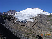
Glaciologists researching the North Cascades glaciers have found that all 47 monitored glaciers are receding and that four glaciers—Spider Glacier, Lewis Glacier, Milk Lake Glacier, and David Glacier—have disappeared completely since 1985. The White Chuck Glacier (near Glacier Peak
Glacier Peak
Glacier Peak is the most isolated of the five major stratovolcanoes of the Cascade Volcanic Arc in Washington...
) is a particularly dramatic example. The glacier area shrank from 3.1 km² (1.2 sq mi) in 1958 to 0.9 km² (0.347491942733282 sq mi) by 2002. Between 1850 and 1950, the Boulder Glacier on the southeast flank of Mount Baker
Mount Baker
Mount Baker , also known as Koma Kulshan or simply Kulshan, is an active glaciated andesitic stratovolcano in the Cascade Volcanic Arc and the North Cascades of Washington State in the United States. It is the second-most active volcano in the range after Mount Saint Helens...
retreated 8700 feet (2,651.8 m). William Long of the United States Forest Service observed the glacier beginning to advance due to cooler/wetter weather in 1953. This was followed by a 2438 feet (743.1 m) advance by 1979. The glacier again retreated 450 m (1,476.4 ft) from 1987 to 2005, leaving barren terrain behind. This retreat has occurred during a period of reduced winter snowfall and higher summer temperatures. In this region of the Cascades, winter snowpack has declined 25% since 1946, and summer temperatures have risen 0.7 °C
Celsius
Celsius is a scale and unit of measurement for temperature. It is named after the Swedish astronomer Anders Celsius , who developed a similar temperature scale two years before his death...
(1.2 °F
Fahrenheit
Fahrenheit is the temperature scale proposed in 1724 by, and named after, the German physicist Daniel Gabriel Fahrenheit . Within this scale, the freezing of water into ice is defined at 32 degrees, while the boiling point of water is defined to be 212 degrees...
) during the same period. The reduced snowpack has occurred despite a small increase in winter precipitation—thus, it reflects warmer winter temperatures leading to rainfall and melting on glaciers even during the winter. As of 2005, 67% of the North Cascade glaciers observed are in disequilibrium and will not survive the continuation of the present climate. These glaciers will eventually disappear unless temperatures fall and frozen precipitation increases. The remaining glaciers are expected to stabilize, unless the climate continues to warm, but will be much reduced in size.
U.S. Rocky Mountains
On the sheltered slopes of the highest peaks of Glacier National Park in MontanaMontana
Montana is a state in the Western United States. The western third of Montana contains numerous mountain ranges. Smaller, "island ranges" are found in the central third of the state, for a total of 77 named ranges of the Rocky Mountains. This geographical fact is reflected in the state's name,...
, its eponymous glaciers are diminishing rapidly. The area of each glacier has been mapped by the National Park Service
National Park Service
The National Park Service is the U.S. federal agency that manages all national parks, many national monuments, and other conservation and historical properties with various title designations...
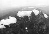
and the U.S. Geological Survey for decades. Comparing photographs taken in the mid-19th century with contemporary images provides ample evidence that the glaciers in the park have retreated notably since 1850. Repeat photography over the decades since clearly show that glaciers throughout the park such as Grinnell Glacier
Grinnell Glacier
Grinnell Glacier is located in the heart of Glacier National Park in the U.S. state of Montana. The glacier is named for George Bird Grinnell, an early American conservationist and explorer, who was also a strong advocate of ensuring the creation of Glacier National Park...
are all retreating. The larger glaciers are now approximately a third of their former size when first studied in 1850, and numerous smaller glaciers have disappeared completely. Only 27% of the 99 km² (38.2 sq mi) area of Glacier National Park covered by glaciers in 1850 remained covered by 1993. Researchers believe that by the year 2030, the vast majority of glacial ice in Glacier National Park will be gone unless current climate patterns reverse their course. Grinnell Glacier is just one of many glaciers in Glacier National Park that have been well documented by photographs for many decades. The photographs below clearly demonstrate the retreat of this glacier since 1938.
The semiarid climate of Wyoming
Wyoming
Wyoming is a state in the mountain region of the Western United States. The western two thirds of the state is covered mostly with the mountain ranges and rangelands in the foothills of the Eastern Rocky Mountains, while the eastern third of the state is high elevation prairie known as the High...
still manages to support about a dozen small glaciers within Grand Teton National Park
Grand Teton National Park
Grand Teton National Park is a United States National Park located in northwestern Wyoming, U.S. The Park consists of approximately and includes the major peaks of the long Teton Range as well as most of the northern sections of the valley known as Jackson Hole. Only south of Yellowstone...
, which all show evidence of retreat over the past 50 years. Schoolroom Glacier
Schoolroom Glacier
Schoolroom Glacier is a small glacier located in Grand Teton National Park in the U.S. state of Wyoming. This Teton Range glacier lies adjacent to the south Cascade Canyon trail at an altitude of , approximately from the trailhead at Jenny Lake...
is located slightly southwest of Grand Teton
Grand Teton
Grand Teton is the highest mountain in Wyoming's Grand Teton National Park, and a classic destination in American mountaineering.- Geography :...
is one of the more easily reached glaciers in the park and it is expected to disappear by 2025. Research between 1950 and 1999 demonstrated that the glaciers in Bridger-Teton National Forest
Bridger-Teton National Forest
Bridger-Teton National Forest is located in western Wyoming, United States. The forest consists of , making it the second largest National Forest outside of Alaska. The forest stretches from Yellowstone National Park, along the eastern boundary of Grand Teton National Park and from there rides...
and Shoshone National Forest
Shoshone National Forest
Shoshone National Forest is the first federally protected National Forest in the United States and covers nearly 2.5 million acres in the state of Wyoming. Originally a part of the Yellowstone Timberland Reserve, the forest was created by an act of Congress and signed into law by U.S....
in the Wind River Range
Wind River Range
The Wind River Range , is a mountain range of the Rocky Mountains in western Wyoming in the United States. The range runs roughly NW-SE for approximately 100 miles . The Continental Divide follows the crest of the range and includes Gannett Peak, which at 13,804 feet , is the highest peak...
shrank by over a third of their size during that period. Photographs indicate that the glaciers today are only half the size as when first photographed in the late 1890s. Research also indicates that the glacial retreat was proportionately greater in the 1990s than in any other decade over the last 100 years. Gannett Glacier
Gannett Glacier
Gannett Glacier is the largest glacier in the Rocky Mountains within the United States. The glacier is located on the east and north slopes of Gannett Peak, the highest mountain in Wyoming on the east side of the Continental Divide in the Wind River Range...
on the northeast slope of Gannett Peak
Gannett Peak
Gannett Peak is the highest peak in the U.S. state of Wyoming and straddles the boundary between Fremont and Sublette Counties along the Continental Divide.- Overview :...
is the largest single glacier in the Rocky Mountains
Rocky Mountains
The Rocky Mountains are a major mountain range in western North America. The Rocky Mountains stretch more than from the northernmost part of British Columbia, in western Canada, to New Mexico, in the southwestern United States...
south of Canada. It has reportedly lost over 50% of its volume since 1920, with almost half of that loss occurring since 1980. Glaciologists believe the remaining glaciers in Wyoming will disappear by the middle of the 21st century if the current climate patterns continue.
Canadian Rockies and British Columbia Coast Range
Canadian Rockies
The Canadian Rockies comprise the Canadian segment of the North American Rocky Mountains range. They are the eastern part of the Canadian Cordillera, extending from the Interior Plains of Alberta to the Rocky Mountain Trench of British Columbia. The southern end borders Idaho and Montana of the USA...
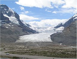
, the glaciers are generally larger and more widespread than they are to the south in the United States Rocky Mountains. One of the more accessible glaciers in the Canadian Rockies is the Athabasca Glacier
Mount Athabasca
Mount Athabasca is located in the Columbia Icefield of Jasper National Park in Canada. The mountain was named in 1898 by J. Norman Collie, who made the first ascent on August 18 of that year...
, which is an outlet glacier of the 325 km² (125.5 sq mi) Columbia Icefield
Columbia Icefield
The Columbia Icefield is an icefield located in the Canadian Rockies, astride the Continental Divide of North America. The icefield lies partly in the northwestern tip of Banff National Park and the southern end of Jasper National Park. It is about 325 km² in area, 100 to 365 metres in depth and...
. The Athabasca Glacier has retreated 1500 m (4,921.3 ft) since the late 19th century. The rate of retreat for this glacier has increased since 1980, following a period of slow retreat from 1950 to 1980. The Peyto Glacier
Peyto Glacier
Peyto Glacier is located in the Canadian Rockies in Banff National Park, Alberta, Canada, approximately northwest of the town of Banff, and can be accessed from the Icefields Parkway. Peyto Glacier is an outflow glacier from the Wapta Icefield, which rests along the Continental divide...
in Alberta
Alberta
Alberta is a province of Canada. It had an estimated population of 3.7 million in 2010 making it the most populous of Canada's three prairie provinces...
covers an area of about 12 km² (4.6 sq mi), and retreated rapidly during the first half of the 20th century, stabilized by 1966, and resumed shrinking in 1976. Illecillewaet Glacier in British Columbia's Glacier National Park (Canada)
Glacier National Park (Canada)
Glacier National Park is one of seven national parks in British Columbia, and is part of a system of 43 parks and park reserves across Canada. It protects a portion of the Columbia Mountains. It also contains the Rogers Pass National Historic Site, designated for its importance in the construction...
has retreated 2 km (1.2 mi) since first photographed in 1887.
In Garibaldi Provincial park in SW British Columbia over 505 km² (195 sq mi), or 26%, of the park, was covered by glacier ice at the beginning of the 18th century. Ice cover decreased to 297 km² (114.7 sq mi) by 1987–1988 and to 245 km² (94.6 sq mi) by 2005, 50% of the 1850 area. The 50 km² (19.3 sq mi) loss in the last 20 years coincides with negative mass balance in the region. During this period all nine glaciers examined have retreated significantly.
Alaska
There are thousands of glaciers in Alaska, though only a relative few of them have been named. The Columbia GlacierColumbia Glacier (Alaska)
The Columbia Glacier is a glacier in Prince William Sound on the south coast of the U.S. state of Alaska. It is one of several glaciers in the area named for elite U.S. colleges, in this case Columbia University, and was named by the Harriman Alaska Expedition in 1899...
near Valdez
Valdez, Alaska
Valdez is a city in Valdez-Cordova Census Area in the U.S. state of Alaska. According to 2005 Census Bureau estimates, the population of the city is 4,020. The city is one of the most important ports in Alaska. The port of Valdez was named in 1790 after the Spanish naval officer Antonio Valdés y...
in Prince William Sound
Prince William Sound
Prince William Sound is a sound off the Gulf of Alaska on the south coast of the U.S. state of Alaska. It is located on the east side of the Kenai Peninsula. Its largest port is Valdez, at the southern terminus of the Trans-Alaska Pipeline System...
has retreated 15 km (9.3 mi) in the last 25 years. Icebergs calved off this glacier were a partial cause of the Exxon Valdez
Exxon Valdez
Oriental Nicety, formerly Exxon Valdez, Exxon Mediterranean, SeaRiver Mediterranean, S/R Mediterranean, Mediterranean, and Dong Fang Ocean is an oil tanker that gained notoriety after running aground in Prince William Sound spilling hundreds of thousands of barrels of crude oil in Alaska...
oil spill, as the oil tanker had changed course to avoid the icebergs. The Valdez Glacier is in the same area, and though it does not calve, it has also retreated significantly. "A 2005 aerial survey of Alaskan coastal glaciers identified more than a dozen glaciers, many former tidewater and calving
Ice calving
Ice calving, also known as glacier calving or iceberg calving, is a form of ice ablation or ice disruption. It is the sudden release and breaking away of a mass of ice from a glacier, iceberg, ice front, ice shelf, or crevasse...
glaciers, including Grand Plateau, Alsek, Bear, and Excelsior Glaciers that are rapidly retreating. Of 2,000 glaciers observed, 99% are retreating." Icy Bay in Alaska is fed by three large glaciers—Guyot, Yahtse, and Tyndall Glaciers—all of which have experienced a loss in length and thickness and, consequently, a loss in area. Tyndall Glacier became separated from the retreating Guyot Glacier in the 1960s and has retreated 24 km (14.9 mi) since, averaging more than 500 m (1,640.4 ft) per year.
The Juneau Icefield Research Program has monitored the outlet glaciers of the Juneau Icefield
Juneau Icefield
The Juneau Icefield is an ice field located just north of Juneau, Alaska and continues north through the border with British Columbia and is the fifth-largest ice field in the Western Hemisphere, extending through an area of in the Coast Range ranging north to south and east to west. The...
since 1946. On the west side of the ice field, the terminus of the Mendenhall Glacier
Mendenhall Glacier
Mendenhall Glacier is a glacier about long located in Mendenhall Valley, about from downtown Juneau in the southeast area of the U.S. state of Alaska....
, which flows into suburban Juneau, Alaska
Juneau, Alaska
The City and Borough of Juneau is a unified municipality located on the Gastineau Channel in the panhandle of the U.S. state of Alaska. It has been the capital of Alaska since 1906, when the government of the then-District of Alaska was moved from Sitka as dictated by the U.S. Congress in 1900...
, has retreated 580 m (1,902.9 ft). Of the nineteen glaciers of the Juneau Icefield, eighteen are retreating, and one, the Taku Glacier, is advancing. Eleven of the glaciers have retreated more than 1 km (0.621372736649807 mi) since 1948 — Antler Glacier, 5.4 km (3.4 mi); Gilkey Glacier, 3.5 km (2.2 mi); Norris Glacier, 1.1 km (0.683510010314787 mi) and Lemon Creek Glacier, 1.5 km (0.93205910497471 mi). Taku Glacier has been advancing since at least 1890, when naturalist John Muir
John Muir
John Muir was a Scottish-born American naturalist, author, and early advocate of preservation of wilderness in the United States. His letters, essays, and books telling of his adventures in nature, especially in the Sierra Nevada mountains of California, have been read by millions...
observed a large iceberg calving front. By 1948 the adjacent fjord
Fjord
Geologically, a fjord is a long, narrow inlet with steep sides or cliffs, created in a valley carved by glacial activity.-Formation:A fjord is formed when a glacier cuts a U-shaped valley by abrasion of the surrounding bedrock. Glacial melting is accompanied by rebound of Earth's crust as the ice...
had filled in, and the glacier no longer calved and was able to continue its advance. By 2005 the glacier was only 1.5 km (0.93205910497471 mi) from reaching Taku Point and blocking Taku Inlet. The advance of Taku Glacier averaged 17 m (55.8 ft) per year between 1988 and 2005. The mass balance was very positive for the 1946–88 period fueling the advance; however, since 1988 the mass balance has been slightly negative, which should in the future slow the advance of this mighty glacier.
Long-term mass balance records from Lemon Creek Glacier in Alaska show slightly declining mass balance with time. The mean annual balance for this glacier was −0.23 m (0.754593175853018 ft) each year during the period of 1957 to 1976. Mean annual balance has been increasingly negatively averaging −1.04 m (3.4 ft) per year from 1990 to 2005. Repeat glacier altimetry, or altitude measuring, for 67 Alaska glaciers find rates of thinning have increased by more than a factor of two when comparing the periods from 1950 to 1995 (0.7 m (2.3 ft) per year) and 1995 to 2001 (1.8 m (5.9 ft) per year). This is a systemic trend with loss in mass equating to loss in thickness, which leads to increasing retreat—the glaciers are not only retreating, but they are also becoming much thinner. In Denali National Park, all glaciers monitored are retreating, with an average retreat of 20 m (65.6 ft) per year. The terminus of the Toklat Glacier has been retreating 26 m (85.3 ft) per year and the Muldrow Glacier has thinned 20 m (65.6 ft) since 1979. Well documented in Alaska are surging
Surge (glacier)
Glacial surges are short-lived events where a glacier can advance substantially, moving at velocities up to 100 times faster than normal. Surging glaciers are clustered around a few areas. High concentrations of surging glaciers can be found in Svalbard, Canadian Arctic islands, Alaska and Iceland...
glaciers that have been known to rapidly advance, even as much as 100 m (328.1 ft) per day. Variegated
Variegated Glacier
Variegated Glacier is one of several glaciers which connect to Russell Fjord in Alaska. Variegated Glacier has been of considerable scientific interest because it surges every 20 years....
, Black Rapids, Muldrow, Susitna and Yanert are examples of surging glaciers in Alaska that have made rapid advances in the past. These glaciers are all retreating overall, punctuated by short periods of advance.
Andes and Tierra del Fuego
A large region of population surrounding the central and southern Andes of Argentina
Argentina
Argentina , officially the Argentine Republic , is the second largest country in South America by land area, after Brazil. It is constituted as a federation of 23 provinces and an autonomous city, Buenos Aires...
and Chile
Chile
Chile ,officially the Republic of Chile , is a country in South America occupying a long, narrow coastal strip between the Andes mountains to the east and the Pacific Ocean to the west. It borders Peru to the north, Bolivia to the northeast, Argentina to the east, and the Drake Passage in the far...
reside in arid areas that are dependent on water supplies from melting glaciers. The water from the glaciers also supplies rivers that have in some cases been dammed for hydroelectric power. Some researchers believe that by 2030, many of the large ice caps on the highest Andes will be gone if current climate trends continue. In Patagonia on the southern tip of the continent, the large ice caps have retreated a 1 km (0.621372736649807 mi) since the early 1990s and 10 km (6.2 mi) since the late 19th century. It has also been observed that Patagonian glaciers are receding at a faster rate than in any other world region. The Northern Patagonian Ice Field
Northern Patagonian Ice Field
The Northern Patagonian Ice Field, located in southern Chile, is the smaller of two remnant parts in which the Patagonian Ice Sheet in the Andes Mountains of lower South America can be divided. It is completely contained within the boundaries of Laguna San Rafael National Park...
lost 93 km² (35.9 sq mi) of glacier area during the years between 1945 and 1975, and 174 km² (67.2 sq mi) from 1975 to 1996, which indicates that the rate of retreat is increasing. This represents a loss of 8% of the ice field, with all glaciers experiencing significant retreat. The Southern Patagonian Ice Field
Southern Patagonian Ice Field
The Southern Patagonian Ice Field , located at the Southern Patagonic Andes between Argentina and Chile, is the second largest contiguous extrapolar extent of ice in the world...
has exhibited a general trend of retreat on 42 glaciers, while four glaciers were in equilibrium and two advanced during the years between 1944 and 1986. The largest retreat was on O'Higgins Glacier
O'Higgins Glacier
O'Higgins Glacier is a glacier located in Bernardo O'Higgins National Park, Chile. It is one of the principal glaciers of the Southern Patagonian Ice Field. The summit of the active Lautaro volcano is the top of the accumulation zone of the glacier. The bulk of the glacier is part of the icefield...
, which during the period 1896–1995 retreated 14.6 km (9.1 mi). The Perito Moreno Glacier
Perito Moreno Glacier
The Perito Moreno Glacier is a glacier located in the Los Glaciares National Park in the south west of Santa Cruz province, Argentina. It is one of the most important tourist attractions in the Argentine Patagonia....
is 30 km (18.6 mi) long and is a major outflow glacier of the Patagonian ice sheet, as well as the most visited glacier in Patagonia. Perito Moreno Glacier is presently in equilibrium, but has undergone frequent oscillations in the period 1947–96, with a net gain of 4.1 km (2.5 mi). This glacier has advanced since 1947, and has been essentially stable since 1992. Perito Moreno Glacier is one of three glaciers in Patagonia known to have advanced, compared to several hundred others in retreat. The two major glaciers of the Southern Patagonia Icefield to the north of Moreno, Upsala and Videma Glacier have retreated 4.6 km (2.9 mi) in 21 years and 1 km (0.621372736649807 mi) in 13 years respectively. In the Aconcagua River
Aconcagua River
For other uses, see Aconcagua .The Aconcagua River is a river in Chile that rises from the joint of two minor tributary rivers at above sea level in the Andes, Juncal river from the east and Blanco river from the south east...
Basin, glacier retreat has resulted in a 20% loss in glacier area, declining from 151 km² (58.3 sq mi) to 121 km² (46.7 sq mi). The Marinelli Glacier
Marinelli Glacier
Marinelli Glacier is a tidewater glacier located in Alberto de Agostini National Park, Isla Grande de Tierra del Fuego. The glacier spills out from the backbone of the Cordillera Darwin and calves into Ainsworth Bay, an embayment of the Almirantazgo Fjord...
in Tierra del Fuego
Tierra del Fuego
Tierra del Fuego is an archipelago off the southernmost tip of the South American mainland, across the Strait of Magellan. The archipelago consists of a main island Isla Grande de Tierra del Fuego divided between Chile and Argentina with an area of , and a group of smaller islands including Cape...
has been in retreat since at least 1960 through 2008.
Tropical glaciers
Tropical glaciers are located between the Tropic of CancerTropic of Cancer
The Tropic of Cancer, also referred to as the Northern tropic, is the circle of latitude on the Earth that marks the most northerly position at which the Sun may appear directly overhead at its zenith...
and the Tropic of Capricorn
Tropic of Capricorn
The Tropic of Capricorn, or Southern tropic, marks the most southerly latitude on the Earth at which the Sun can be directly overhead. This event occurs at the December solstice, when the southern hemisphere is tilted towards the Sun to its maximum extent.Tropic of Capricorn is one of the five...
, in the region that lies 23° 26′ 22″
Latitude
In geography, the latitude of a location on the Earth is the angular distance of that location south or north of the Equator. The latitude is an angle, and is usually measured in degrees . The equator has a latitude of 0°, the North pole has a latitude of 90° north , and the South pole has a...
north or south of the equator
Equator
An equator is the intersection of a sphere's surface with the plane perpendicular to the sphere's axis of rotation and containing the sphere's center of mass....
. Tropical glaciers are the most uncommon of all glaciers for a variety of reasons. Firstly, the tropics are the warmest part of the planet. Secondly, the seasonal change is minimal with temperatures warm year round, resulting in a lack of a colder winter season in which snow and ice can accumulate. Thirdly, few taller mountains exist in these regions upon which enough cold air exists for the establishment of glaciers. All of the glaciers located in the tropics are on isolated high mountain peaks. Overall, tropical glaciers are smaller than those found elsewhere and are the most likely glaciers to show rapid response to changing climate patterns. A small temperature increase of only a few degrees can have almost immediate and adverse impact on tropical glaciers.
Near the Equator, ice is still found in East Africa, the Ecuadorian Andes, and New Guinea. The retreat of equatorial glaciers has been documented via maps and photographs covering the period from the late 1800s to nearly the present.
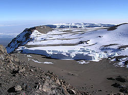
Africa
Ruwenzori Range
The Rwenzori Mountains, previously called the Ruwenzori Range , and sometimes the Mountains of the Moon, is a mountain range of central Africa, often referred to as Mt...
. Kilimanjaro, at 5895 m (19,340.6 ft), is the highest peak on the continent. Since 1912 the glacier cover on the summit of Kilimanjaro has apparently retreated 75%, and the volume of glacial ice is now 80% less than it was a century ago due to both retreat and thinning. In the 14-year period from 1984 to 1998, one section of the glacier atop the mountain receded 300 m (984.3 ft). A 2002 study determined that if current conditions continue, the glaciers atop Kilimanjaro will disappear sometime between 2015 and 2020. A March 2005 report indicated that there is almost no remaining glacial ice on the mountain, and it is the first time in 11,000 years that barren ground has been exposed on portions of the summit. Researchers reported Kilimanjaro's glacier retreat was due to a combination of increased sublimation and decreased snow fall.
The Furtwängler Glacier
Furtwängler Glacier
The Furtwängler Glacier is located near the summit of Mount Kilimanjaro in Tanzania. Furtwängler Glacier is a small remnant of an enormous icecap which once crowned the summit of Mount Kilimanjaro. This icecap has retreated significantly over the past century; between 1912 and 2000, 82 percent of...
is located near the summit of Kilimanjaro. Between 1976 and 2000, the area of Furtwängler Glacier was cut almost in half, from 113000 square metre to 60000 square metre. During fieldwork conducted early in 2006, scientists discovered a large hole near the center of the glacier. This hole, extending through the 6 m (19.7 ft) remaining thickness of the glacier to the underlying rock, was expected to grow and split the glacier in two by 2007.
To the north of Kilimanjaro lies Mount Kenya
Mount Kenya
Mount Kenya is the highest mountain in Kenya and the second-highest in Africa, after Kilimanjaro. The highest peaks of the mountain are Batian , Nelion and Point Lenana . Mount Kenya is located in central Kenya, just south of the equator, around north-northeast of the capital Nairobi...
, which at 5199 m (17,057.1 ft) is the second tallest mountain on the African continent. Mount Kenya has a number of small glaciers that have lost at least 45% of their mass since the middle of the 20th century. According to research compiled by the U.S. Geological Survey (USGS), there were eighteen glaciers atop Mount Kenya in 1900, and by 1986 only eleven remained. The total area covered by glaciers was 1.6 km² (0.617763453748056 sq mi) in 1900, however by the year 2000 only about 25%, or 0.4 km² (0.154440863437014 sq mi) remained. To the west of Mounts Kilimanjaro and Kenya, the Ruwenzori Range rises to 5109 m (16,761.8 ft). Photographic evidence of this mountain range indicates a marked reduction in glacially covered areas over the past century. In the 35-year period between 1955 and 1990, glaciers on the Rwenzori Mountains receded about 40%. It is expected that due to their proximity to the heavy moisture of the Congo
Congo River
The Congo River is a river in Africa, and is the deepest river in the world, with measured depths in excess of . It is the second largest river in the world by volume of water discharged, though it has only one-fifth the volume of the world's largest river, the Amazon...
region, the glaciers in the Ruwenzori Range may recede at a slower rate than those on Kilimanjaro or in Kenya.
South America
A study by glaciologists of two small glaciers in South America reveals another retreat. More than 80% of all glacial ice in the northern Andes is concentrated on the highest peaks in small glaciers of approximately 1 km² (0.386102158592535 sq mi) in size. A 1992 to 1998 observation of the ChacaltayaChacaltaya
Chacaltaya is a mountain in the Cordillera Real, one of the mountain ranges of the Cordillera Oriental, itself a range of the Bolivian Andes. Its elevation is . Chacaltaya's glacier - which was as old as 18,000 years – had in 1940 an area of , reduced to in 2007 and was completely gone by 2009....
Glacier in Bolivia
Bolivia
Bolivia officially known as Plurinational State of Bolivia , is a landlocked country in central South America. It is the poorest country in South America...
and Antizana Glacier in Ecuador
Ecuador
Ecuador , officially the Republic of Ecuador is a representative democratic republic in South America, bordered by Colombia on the north, Peru on the east and south, and by the Pacific Ocean to the west. It is one of only two countries in South America, along with Chile, that do not have a border...
indicated that between 0.6 m (2 ft) and 1.9 m (6.2 ft) of ice was lost per year on each glacier. Figures for Chacaltaya Glacier show a loss of 67% of its volume and 40% of its thickness over the same period. Chacaltaya Glacier has lost 90% of its mass since 1940 and is expected to disappear altogether sometime between 2010 and 2015. Research also indicates that since the mid-1980s, the rate of retreat for both of these glaciers has been increasing. In Colombia
Colombia
Colombia, officially the Republic of Colombia , is a unitary constitutional republic comprising thirty-two departments. The country is located in northwestern South America, bordered to the east by Venezuela and Brazil; to the south by Ecuador and Peru; to the north by the Caribbean Sea; to the...
, the glaciers atop Nevado del Ruiz
Nevado del Ruiz
The Nevado del Ruiz, also known as La Mesa de Herveo or Kumanday in the language of the local pre-Columbian indigenous people, is a volcano located on the border of the departments of Caldas and Tolima in Colombia, about west of the capital city Bogotá. It is a stratovolcano, composed of many...
have lost more than half their area in the last 40 years. Further south in Peru
Peru
Peru , officially the Republic of Peru , is a country in western South America. It is bordered on the north by Ecuador and Colombia, on the east by Brazil, on the southeast by Bolivia, on the south by Chile, and on the west by the Pacific Ocean....
, the Andes are at a higher altitude overall, and there are approximately 722 glaciers covering an area of 723 km² (279.2 sq mi). Research in this region of the Andes is less extensive but indicates an overall glacial retreat of 7% between 1977 and 1983. The Quelccaya Ice Cap
Quelccaya Ice Cap
The Quelccaya Ice Cap is the largest glaciated area in the tropics. Located in the Cordillera Oriental section of the Andes mountains of Peru, the ice cap is at an average altitude of 5,470 meters and spans an area of 44 square kilometers...
is the largest tropical icecap in the world, and all of the outlet glaciers from the icecap are retreating. In the case of Qori Kalis Glacier, which is Quelccayas' main outlet glacier, the rate of retreat had reached 155 m (508.5 ft) per year during the three year period of 1995 to 1998. The melting ice has formed a large lake at the front of the glacier since 1983, and bare ground has been exposed for the first time in thousands of years.
Oceania
New Guinea
New Guinea is the world's second largest island, after Greenland, covering a land area of 786,000 km2. Located in the southwest Pacific Ocean, it lies geographically to the east of the Malay Archipelago, with which it is sometimes included as part of a greater Indo-Australian Archipelago...
, there is photographic evidence of massive glacial retreat since the region was first extensively explored by airplane in the early 1930s. Due to the location of the island within the tropical zone, there is little to no seasonal variation in temperature. The tropical location has a predictably steady level of rain and snowfall, as well as cloud cover year round, and there has been no noticeable change in the amount of moisture which has fallen during the 20th century. The 7 km² (2.7 sq mi) ice cap on Puncak Jaya
Puncak Jaya
Puncak Jaya or Carstensz Pyramid is the highest summit of Mount Carstensz in the Sudirman Range of the western central highlands of Papua province, Indonesia . Other summits are East Carstensz Peak and Ngga Pulu...
is the largest on the island, and has retreated from one larger mass into several smaller glacial bodies since 1936. Of these smaller glaciers, research between 1973 and 1976 showed glacier retreat for the Meren Glacier of 200 m (656.2 ft) while the Carstensz Glacier lost 50 m (164 ft). The Northwall Firn, another large remnant of the icecap that once was atop Puncak Jaya
Puncak Jaya
Puncak Jaya or Carstensz Pyramid is the highest summit of Mount Carstensz in the Sudirman Range of the western central highlands of Papua province, Indonesia . Other summits are East Carstensz Peak and Ngga Pulu...
, has itself split into several separate glaciers since 1936. Research presented in 2004 of IKONOS
IKONOS
IKONOS is a commercial earth observation satellite, and was the first to collect publicly available high-resolution imagery at 1- and 4-meter resolution. It offers multispectral and panchromatic imagery. The IKONOS launch was called by John E. Pike “one of the most significant developments in...
satellite imagery
Satellite imagery
Satellite imagery consists of photographs of Earth or other planets made by means of artificial satellites.- History :The first images from space were taken on sub-orbital flights. The U.S-launched V-2 flight on October 24, 1946 took one image every 1.5 seconds...
of the New Guinean glaciers provided a dramatic update. The imagery indicated that in the two years from 2000 to 2002, the East Northwall Firn had lost 4.5%, the West Northwall Firn 19.4% and the Carstensz 6.8% of their glacial mass. Researchers also discovered that, sometime between 1994 and 2000, the Meren Glacier disappeared altogether. An expedition to the remaining glaciers on Puncak Jaya in 2010 discovered that the ice on the glaciers there is about 32 metres (105 ft) thick and thinning at a rate of 7 metres (23 ft) annually. At that rate, the remaining glaciers are expected to last only to the year 2015. Separate from the glaciers of Puncak Jaya, another small icecap known to have existed on the summit of Puncak Trikora
Puncak Trikora
Puncak Trikora, until 1963 Wilhelmina Peak, is a 4730 or high mountain in the Papua province of Indonesia on New Guinea. It lies in the eastern part of the Sudirman Range of the Maoke Mountains. Behind Puncak Jaya at , it is either the second or third highest mountain on the island of New Guinea...
completely disappeared sometime between 1939 and 1962.
Polar regions
Despite their proximity and importance to human populations, the mountain and valley glaciers of tropical and mid-latitude glaciers amount to only a small fraction of glacial ice on the Earth. About 99 percent of all freshwater ice is in the great ice sheets of polar and subpolar Antarctica and GreenlandGreenland
Greenland is an autonomous country within the Kingdom of Denmark, located between the Arctic and Atlantic Oceans, east of the Canadian Arctic Archipelago. Though physiographically a part of the continent of North America, Greenland has been politically and culturally associated with Europe for...
. These continuous continental-scale ice sheets, 3 km (1.9 mi) or more in thickness, cap much of the polar and subpolar land masses. Like rivers flowing from an enormous lake, numerous outlet glaciers transport ice from the margins of the ice sheet to the ocean.
Iceland
The northern Atlantic island nation of IcelandIceland
Iceland , described as the Republic of Iceland, is a Nordic and European island country in the North Atlantic Ocean, on the Mid-Atlantic Ridge. Iceland also refers to the main island of the country, which contains almost all the population and almost all the land area. The country has a population...
is home to the Vatnajökull
Vatnajökull
Vatnajökull is the largest glacier in Iceland. It is located in the south-east of the island, covering more than 8% of the country.-Size:With an area of 8,100 km², Vatnajökull is the largest ice cap in Europe by volume and the second largest in area Vatnajökull is the largest glacier in...
, which is the largest ice cap in Europe. The Breiðamerkurjökull Glacier is one of the Vatnajökull outlet glaciers, and had receded by as much as 2 km (1.2 mi) between 1973 and 2004. In the early 20th century, Breiðamerkurjökull extended to within 250 m (820.2 ft) of the ocean, but by 2004 Breiðamerkurjökull's terminus had retreated 3 km (1.9 mi) further inland. This glacier retreat exposed a rapidly expanding lagoon that is filled with icebergs calved from its front. The lagoon is 110 m (360.9 ft) deep and nearly doubled its size between 1994 and 2004. Mass-balance measurements of Iceland's glaciers show alternating positive and negative mass balance of glaciers during the period 1987–95, but the mass balance has been predominantly negative since. On Hofsjökull ice cap, mass balance has been negative each year from 1995–2005.
Most of the Icelandic glaciers retreated rapidly during the warm decades from 1930 to 1960, slowing down as the climate cooled during the following decade, and started to advance after 1970. The rate of advance peaked in the 1980s, after which it slowed down until about 1990. As a consequence of rapid warming of the climate that has taken place since the mid-1980s, most glaciers in Iceland began to retreat after 1990, and by 2000 all monitored non-surge type glaciers in Iceland were retreating. An average of 45 non-surging termini were monitored each year by the Icelandic Glaciological Society from 2000–2005.
Canada
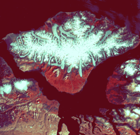
Penny Ice Cap
The Penny Ice Cap is a vast, ice cap in Auyuittuq National Park of Baffin Island, Nunavut, Canada. It forms a high barrier on the Cumberland Peninsula, an area of deep fiords and glaciated valleys. It is a remnant of the last ice age. During the mid 1990s, Canadian researchers studied the...
and Barnes
Barnes Ice Cap
The Barnes Ice Cap is an ice cap located in central Baffin Island, Nunavut, Canada. It covers close to and has been thinning due to regional warming. Between 2004 and 2006, the ice cap was thinning at a rate of per year....
ice caps on Baffin Island
Baffin Island
Baffin Island in the Canadian territory of Nunavut is the largest island in the Canadian Arctic Archipelago, the largest island in Canada and the fifth largest island in the world. Its area is and its population is about 11,000...
, Bylot Ice Cap on Bylot Island
Bylot Island
Bylot Island lies off the northern end of Baffin Island in Nunavut Territory, Canada. At it is ranked 71st largest island in the world and Canada's 17th largest island. It is also one of the largest uninhabited islands in the world. While there are no permanent settlements on this Canadian Arctic...
, and Devon Ice Cap
Devon Ice Cap
The Devon Ice Cap is an ice cap on eastern Devon Island covering an area of over . The highest point on Devon Island is found at the summit of the ice cap, with an elevation of . The ice cap has a maximum thickness of ....
on Devon Island
Devon Island
Devon Island , claimed to be the largest uninhabited island on Earth, is located in Baffin Bay, Qikiqtaaluk Region, Nunavut, Canada. It is one of the larger members of the Canadian Arctic Archipelago, the second-largest of the Queen Elizabeth Islands, Canada's sixth largest island, and the 27th...
. All of these ice caps have been thinning and receding slowly. The Barnes and Penny ice caps on Baffin Island have been thinning at over 1 m (3.3 ft) per year in the lower elevations from 1995 to 2000. Overall, between 1995 and 2000, ice caps in the Canadian Arctic lost 25 km² (9.7 sq mi) of ice per year. Between 1960 and 1999, the Devon Ice Cap lost 67 km³ (16.1 cu mi) of ice, mainly through thinning. All major outlet glaciers along the eastern Devon Ice Cap margin have retreated from 1 km (0.621372736649807 mi) to 3 km (1.9 mi) since 1960. On the Hazen Plateau of Ellesmere Island
Ellesmere Island
Ellesmere Island is part of the Qikiqtaaluk Region of the Canadian territory of Nunavut. Lying within the Canadian Arctic Archipelago, it is considered part of the Queen Elizabeth Islands, with Cape Columbia being the most northerly point of land in Canada...
, the Simmon Ice Cap has lost 47% of its area since 1959. If the current climatic conditions continue, the remaining glacial ice on the Hazen Plateau will be gone around 2050. On August 13, 2005 the Ayles Ice Shelf
Ayles Ice Shelf
The Ayles Ice Shelf was one of six major ice shelves in Canada, all located on the northern coast of Ellesmere Island, Nunavut. The ice shelf broke off from the coast on August 13, 2005, forming a giant ice island thick and measuring around by in size . The oldest ice in the ice shelf is...
broke free from the north coast of Ellesmere Island, the 66 km² (25.5 sq mi) ice shelf drifted into the Arctic Ocean. This followed the splitting of the Ward Hunt Ice Shelf in 2002. The Ward Hunt has lost 90% of its area in the last century.
Northern Europe
Arctic islands north of Norway, FinlandFinland
Finland , officially the Republic of Finland, is a Nordic country situated in the Fennoscandian region of Northern Europe. It is bordered by Sweden in the west, Norway in the north and Russia in the east, while Estonia lies to its south across the Gulf of Finland.Around 5.4 million people reside...
and Russia have all shown evidence of glacier retreat. In the Svalbard
Svalbard
Svalbard is an archipelago in the Arctic, constituting the northernmost part of Norway. It is located north of mainland Europe, midway between mainland Norway and the North Pole. The group of islands range from 74° to 81° north latitude , and from 10° to 35° east longitude. Spitsbergen is the...
archipelago
Archipelago
An archipelago , sometimes called an island group, is a chain or cluster of islands. The word archipelago is derived from the Greek ἄρχι- – arkhi- and πέλαγος – pélagos through the Italian arcipelago...
, the island of Spitsbergen
Spitsbergen
Spitsbergen is the largest and only permanently populated island of the Svalbard archipelago in Norway. Constituting the western-most bulk of the archipelago, it borders the Arctic Ocean, the Norwegian Sea and the Greenland Sea...
has numerous glaciers. Research indicates that Hansbreen (Hans Glacier) on Spitsbergen retreated 1.4 km (0.869921831309729 mi) from 1936 to 1982 and another 400 m (1,312.3 ft) during the 16-year period from 1982 to 1998. Blomstrandbreen, a glacier in the King's Bay area of Spitsbergen, has retreated approximately 2 km (1.2 mi) in the past 80 years. Since 1960 the average retreat of Blomstrandbreen has been about 35 m (114.8 ft) a year, and this average was enhanced due to an accelerated rate of retreat since 1995. Similarly, Midre Lovenbreen retreated 200 m (656.2 ft) between 1977 and 1995. In the Novaya Zemlya
Novaya Zemlya
Novaya Zemlya , also known in Dutch as Nova Zembla and in Norwegian as , is an archipelago in the Arctic Ocean in the north of Russia and the extreme northeast of Europe, the easternmost point of Europe lying at Cape Flissingsky on the northern island...
archipelago north of Russia, research indicates that in 1952 there was 208 km (129.2 mi) of glacier ice along the coast. By 1993 this had been reduced by 8% to 198 km (123 mi) of glacier coastline.
Greenland
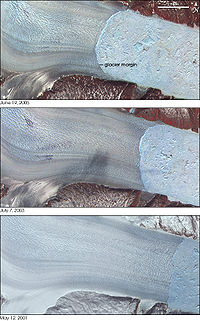
Greenland
Greenland is an autonomous country within the Kingdom of Denmark, located between the Arctic and Atlantic Oceans, east of the Canadian Arctic Archipelago. Though physiographically a part of the continent of North America, Greenland has been politically and culturally associated with Europe for...
, glacier retreat has been observed in outlet glaciers, resulting in an increase of the ice flow rate and destabilization of the mass balance of the ice sheet that is their source. The net loss in volume and hence sea level contribution of the Greenland Ice Sheet (GIS) has doubled in recent years from 90 km³ (21.6 cu mi) to 220 km³ (52.8 cu mi) per year. Researchers also noted that the acceleration was widespread affecting almost all glaciers south of 70 N by 2005. The period since 2000 has brought retreat to several very large glaciers that had long been stable. Three glaciers that have been researched—Helheim Glacier
Helheim Glacier
Helheim Glacier is one of Greenland's largest outlet glaciers. It accelerated from per year in 2000 to per year in 2005. Like many of Greenland's outlet glaciers it is the site of glacial earthquakes.-External links:...
, Kangerdlugssuaq Glacier
Kangerdlugssuaq Glacier
Kangerdlugssuaq Glacier is the largest glacier on the east coast of the Greenland ice sheet. It flows into the Denmark Strait.-External links:...
, and Jakobshavn Isbræ
Jakobshavn Isbræ
Jakobshavn Isbræ, also known as the Jakobshavn Glacier and Sermeq Kujalleq is a large outlet glacier in West Greenland. It is located near the Greenlandic town of Ilulissat and ends at the sea in the Ilulissat Icefjord....
—jointly drain more than 16% of the Greenland Ice Sheet
Greenland ice sheet
The Greenland ice sheet is a vast body of ice covering , roughly 80% of the surface of Greenland. It is the second largest ice body in the world, after the Antarctic Ice Sheet. The ice sheet is almost long in a north-south direction, and its greatest width is at a latitude of 77°N, near its...
. In the case of Helheim Glacier, researchers used satellite images to determine the movement and retreat of the glacier. Satellite images and aerial photographs from the 1950s and 1970s show that the front of the glacier had remained in the same place for decades. In 2001 the glacier began retreating rapidly, and by 2005 the glacier had retreated a total of 7.2 km (4.5 mi), accelerating from 20 m (65.6 ft) per day to 35 m (114.8 ft) per day during that period.
Jakobshavn Isbræ in west Greenland, a major outlet glacier of the Greenland Ice Sheet, has been the fastest moving glacier in the world over the past half century. It had been moving continuously at speeds of over 24 m (78.7 ft) per day with a stable terminus since at least 1950. In 2002 the 12 km (7.5 mi) long floating terminus of the glacier entered a phase of rapid retreat, with the ice front breaking up and the floating terminus disintegrating and accelerating to a retreat rate of over 30 m (98.4 ft) per day. On a shorter timescale, portions of the main trunk of Kangerdlugssuaq Glacier that were flowing at 15 m (49.2 ft) per day from 1988 to 2001 were measured to be flowing at 40 m (131.2 ft) per day in the summer of 2005. Not only has Kangerdlugssuaq retreated, it has also thinned by more than 100 m (328.1 ft).
The rapid thinning, acceleration and retreat of Helheim, Jakobshavns and Kangerdlugssuaq glaciers in Greenland, all in close association with one another, suggests a common triggering mechanism, such as enhanced surface melting due to regional climate warming or a change in forces at the glacier front. The enhanced melting leading to lubrication of the glacier base has been observed to cause a small seasonal velocity increase and the release of meltwater lakes has also led to only small short term accelerations. The significant accelerations noted on the three largest glaciers began at the calving in front and propagated inland and are not seasonal in nature. Thus, the primary source of outlet glacier acceleration widely observed on small and large calving glaciers in Greenland is driven by changes in dynamic forces at the glacier front, not enhanced meltwater lubrication. This was termed the Jakobshavns Effect by Terence Hughes at the University of Maine
University of Maine
The University of Maine is a public research university located in Orono, Maine, United States. The university was established in 1865 as a land grant college and is referred to as the flagship university of the University of Maine System...
in 1986.
Antarctica
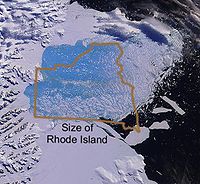
Climate of Antarctica
The climate of Antarctica is the coldest on the whole of Earth. Antarctica has the lowest naturally occurring temperature ever recorded on the ground on Earth: −89.2 °C at Vostok Station. It is also extremely dry , averaging 166 mm of precipitation per year...
is one of intense cold and great aridity. Most of the world's freshwater ice is contained in the great ice sheets that cover the continent of Antarctica. The most dramatic example of glacier retreat on the continent is the loss of large sections of the Larsen Ice Shelf
Larsen Ice Shelf
The Larsen Ice Shelf is a long, fringing ice shelf in the northwest part of the Weddell Sea, extending along the east coast of Antarctic Peninsula from Cape Longing to the area just southward of Hearst Island...
on the Antarctic Peninsula
Antarctic Peninsula
The Antarctic Peninsula is the northernmost part of the mainland of Antarctica. It extends from a line between Cape Adams and a point on the mainland south of Eklund Islands....
. Ice shelves are not stable when surface melting occurs, and the collapse of Larsen Ice Shelf has been caused by warmer melt season temperatures that have led to surface melting and the formation of shallow ponds of water on the ice shelf. The Larsen Ice Shelf lost 2500 km² (965.3 sq mi) of its area from 1995 to 2001. In a 35-day period beginning on January 31, 2002, about 3250 km² (1,254.8 sq mi) of shelf area disintegrated. The ice shelf is now 40% the size of its previous minimum stable extent. The recent collapse of Wordie Ice Shelf, Prince Gustav Ice Shelf, Mueller Ice Shelf, Jones Ice Shelf, Larsen-A and Larsen-B Ice Shelf on the Antarctic Peninsula has raised awareness of how dynamic ice shelf systems are. Jones Ice Shelf had an area of 35 km² (14 sq mi) in the 1970s but by 2008 it had disappeared. Wordie Ice Shelf has gone from an area of 1500 km² (579.2 sq mi) in 1950 to 1400 km² (540.5 sq mi) in 2000. Prince Gustav Ice Shelf has gone from an area of 1600 km² (617.8 sq mi) to 1100 km² (424.7 sq mi) in 2008. After their loss the reduced buttressing of feeder glaciers has allowed the expected speed-up of inland ice masses after shelf ice break-up. The Wilkins Ice Shelf is another ice shelf that has suffered substantial retreat. The ice shelf had an area of 16000 km² (6,177.6 sq mi) in 1998 when 1000 km² (386.1 sq mi) was lost that year. In 2007 and 2008 significant rifting developed and led to the loss of another 1400 km² (540.5 sq mi) of area and some of the calving occurred in the Austral winter. The calving seemed to have resulted from preconditioning such as thinning, possibly due to basal melt, as surface melt was not as evident, leading to a reduction in the strength of the pinning point connections. The thinner ice then experienced spreading rifts and breakup. This period culminated in the collapse of an ice bridge connecting the main ice shelf to Charcot Island leading to the loss of an additional 700 km² (270.3 sq mi) between February and June 2009.
Pine Island Glacier
Pine Island Glacier
- Ice sheet drainage :The Antarctic ice sheet is the largest mass of ice on earth, containing a volume of water equivalent to of global sea level. The ice sheet forms from snow which falls onto the continent and compacts under its own weight. The ice then moves under its own weight toward the...
, an Antarctic outflow glacier that flows into the Amundsen Sea
Amundsen Sea
The Amundsen Sea is an arm of the Southern Ocean off Marie Byrd Land in western Antarctica. It is bounded by Cape Flying Fish, the northwestern tip of Thurston Island to the east and Cape Dart on Siple Island to the west. East of Cape Flying Fish starts the Bellingshausen Sea. West of Cape Dart is...
, thinned 3.5 m (11.5 ft)± 0.9 m (3 ft) per year and retreated a total of 5 km (3.1 mi) in 3.8 years. The terminus of the Pine Island Glacier is a floating ice shelf, and the point at which it starts to float retreated 1.2 km (0.745647283979768 mi) per year from 1992 to 1996. This glacier drains a substantial portion of the West Antarctic Ice Sheet
West Antarctic Ice Sheet
The West Antarctic Ice Sheet is the segment of the continental ice sheet that covers West Antarctica, the portion of Antarctica on the side of the Transantarctic Mountains which lies in the Western Hemisphere. The WAIS is classified as a marine-based ice sheet, meaning that its bed lies well...
and along with the neighboring Thwaites Glacier
Thwaites Glacier
Thwaites Glacier is an unusually broad and fast Antarctic glacier flowing into Pine Island Bay, part of the Amundsen Sea, east of Mount Murphy, on the Walgreen Coast of Marie Byrd Land. Its surface speeds exceed 2 km/yr near its grounding line, and its fastest flowing grounded ice is centred...
, which has also shown evidence of thinning, has been referred to as the weak underbelly of this ice sheet. Additionally, the Dakshin Gangotri Glacier, a small outlet glacier of the Antarctic ice sheet, receded at an average rate of 0.7 m (2.3 ft) per year from 1983 to 2002. On the Antarctic Peninsula, which is the only section of Antarctica that extends well north of the Antarctic Circle, there are hundreds of retreating glaciers. In one study of 244 glaciers on the peninsula, 212 have retreated an average of 600 m (1,968.5 ft) from where they were when first measured in 1953. The greatest retreat was seen in Sjogren Glacier, which is now 13 km (8.1 mi) further inland than where it was in 1953. There are 32 glaciers that were measured to have advanced; however, these glaciers showed only a modest advance averaging 300 m (984.3 ft) per glacier, which is significantly smaller than the massive retreat observed.
Impacts of glacier retreat
The continued retreat of glaciers will have a number of different quantitative impacts. In areas that are heavily dependent on water runoff from glaciers that melt during the warmer summer months, a continuation of the current retreat will eventually deplete the glacial ice and substantially reduce or eliminate runoff. A reduction in runoff will affect the ability to irrigateIrrigation
Irrigation may be defined as the science of artificial application of water to the land or soil. It is used to assist in the growing of agricultural crops, maintenance of landscapes, and revegetation of disturbed soils in dry areas and during periods of inadequate rainfall...
crops and will reduce summer stream flows necessary to keep dams and reservoirs replenished. This situation is particularly acute for irrigation in South America, where numerous artificial lakes are filled almost exclusively by glacial melt. Central Asian countries have also been historically dependent on the seasonal glacier melt water for irrigation and drinking supplies. In Norway, the Alps, and the Pacific Northwest
Pacific Northwest
The Pacific Northwest is a region in northwestern North America, bounded by the Pacific Ocean to the west and, loosely, by the Rocky Mountains on the east. Definitions of the region vary and there is no commonly agreed upon boundary, even among Pacific Northwesterners. A common concept of the...
of North America, glacier runoff is important for hydropower.
Some of this retreat has resulted in efforts to slow down the loss of glaciers in the Alps. To retard melting of the glaciers used by certain Austrian ski resorts, portions of the Stubai
Stubai Alps
The Stubai Alps is a mountain range in the Central Eastern Alps of Europe. It is named after the Stubaital valley to its east. It is located southwest of Innsbruck, Austria, and several summits of the range form part of Austria's border with Italy...
and Pitztal Glaciers were partially covered with plastic. In Switzerland plastic sheeting is also used to reduce the melt of glacial ice used as ski slopes. While covering glaciers with plastic sheeting may prove advantageous to ski resorts on a small scale, this practice is not expected to be economically practical on a much larger scale.
Many species of freshwater and saltwater plants and animals are dependent on glacier-fed waters to ensure the cold water habitat to which they have adapted. Some species of freshwater fish need cold water to survive and to reproduce, and this is especially true with salmon
Salmon
Salmon is the common name for several species of fish in the family Salmonidae. Several other fish in the same family are called trout; the difference is often said to be that salmon migrate and trout are resident, but this distinction does not strictly hold true...
and cutthroat trout
Cutthroat trout
The cutthroat trout is a species of freshwater fish in the salmon family of order Salmoniformes. It is one of the many fish species colloquially known as trout...
. Reduced glacial runoff can lead to insufficient stream flow to allow these species to thrive. Alterations to the ocean currents, due to increased freshwater inputs from glacier melt, and the potential alterations to thermohaline circulation
Thermohaline circulation
The term thermohaline circulation refers to a part of the large-scale ocean circulation that is driven by global density gradients created by surface heat and freshwater fluxes....
of the World Ocean
World Ocean
The World Ocean, world ocean, or global ocean, is the interconnected system of the Earth's oceanic waters, and comprises the bulk of the hydrosphere, covering almost 71% of the Earth's surface, with a total volume of 1.332 billion cubic kilometres.The unity and continuity of the World Ocean, with...
, may impact existing fisheries upon which humans depend as well.
The potential for major sea level rise depends mostly on a significant melting of the polar ice caps of Greenland and Antarctica, as this is where the vast majority of glacial ice is located. If all the ice on the polar ice caps were to melt away, the oceans of the world would rise an estimated 70 m (229.7 ft). Although previously it was thought that the polar ice caps were not contributing heavily to sea level rise (IPCC 2007), recent studies have confirmed that both Antarctica and Greenland are contributing 0.5 millimetre (0.0196850393700787 in) a year each to global sea level rise. The fact that the IPCC estimates did not include rapid ice sheet decay into their sea level predictions makes it difficult to ascertain a plausible estimate for sea level rise but recent studies find that the minimum sea level rise will be around 0.8 metres (2.6 ft) by 2100.