
.gif)
Nilgiris (mountains)
Encyclopedia
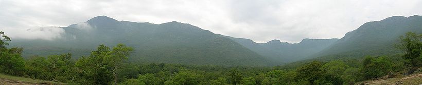
The Nilgiri often referred to as the Nilgiri Hills, are a range of mountains with at least 24 peaks above 2000 metres (6,561.7 ft), in the westernmost part of Tamil Nadu
state at the junction of Karnataka
and Kerala
states in Southern India. They are part of the larger Western Ghats
mountain chain making up the southwestern edge of the Deccan Plateau
.
and Palni Hills
to the south by the Palghat Gap. The Nilgiris District of Tamil Nadu
lies within these mountains. Its latitudinal and longitudinal dimensions are 130 km (Latitude: 11° 08' to 11° 37' N) by 185 km (Longitude: 76° 27' E to 77° 4' E). Central location is: 11°22′30"N 76°45′30"E. It has an area of 2479 square kilometres (957.1 sq mi).
, Nilgiri Sub-Cluster (6,000+ km²), including all of Mukurthi National Park
in the south-eastern corner of the Nilgiris, is under consideration by the UNESCO
World Heritage Committee for selection as a World Heritage Site
.
The Nilgiri Biosphere Reserve
, which includes the Nilgiri Hills, is part of the UNESCO
World Network of Biosphere Reserves
.
 The first recorded use of the word Nila applied to this region can be traced to 1117 AD in the report of a general of Vishnuvardhana
, King of Hoysalas, who in reference to his enemies, claimed to have “frightened the Todas
, driven the Kanga
s underground, slaughtered the Pallava
s, put to death the Malayala
s, terrified King Kala
and then proceeded to offer the peak of Nila Mountain (presumably Dodabetta) to Lakshmi
, Goddess of Wealth.
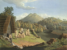
The original inhabitants
of the Nilgiri Hills were the Toda, Badaga, Kota, Irula and kurumbas. The Nilgiri Hills were part of Chera Empire in ancient times. Later, the area came under the rule of the Western Ganga Dynasty, and then Hoysala empire in the 12th century. They then became part of the Kingdom of Mysore
of Tipu Sultan
who later surrendered them to the British in the 18th century.
The first Europeans to attempt the grueling climb to the Nilgiris included an enigmatic Jesuit priest, Father Fininicio, in 1603. They struggled up the mountains, avoiding elephants, tigers and other wild beasts, and met the Todas at the top.
From 1799 these mountains were seen daily by the British authorities from the plains of Coimbatore
. Revenue was collected from them for the British East India Company
by a native renter.
Excepting Dr. Ford and Capt. Bevan, who traversed the hills in 1809 with a party of pioneers, and some deputy surveyors under Colonel Monson, who partially mapped the area, no British had ventured to explore the all but unknown region.
In 1814, Mr, Keys, a sub-assistant, and Mr. McMahon, an apprentice in the Survey Department, ascended the hills by the Danaynkeucottah Pass, penetrated into the remotest parts, made plans, and sent in reports of their discoveries. As a result of these accounts, Messrs. Whish and Kindersley, two young Madras civilians, ventured up in pursuit of some
criminal's taking refuge in the mountains, and proceeded to reconnoitre the interior. They soon saw and felt
enough favorable climate and terrain to excite their own curiosity and that of others.
In 1819, John Sullivan
, the British Collector of Coimbatore, set out to explore the Nilgiris after obtaining an order from the British East India Company charging him to investigate the "origin of the fabulous tales that are circulated concerning the Blue Mountains to verify their authenticity and to send a report to the authorities".
With a detachment of Europeans and Indian sepoy
s, he set out on his mission on January 2, 1819. The journey involved crossing rough and harsh terrain, steep precipices and danger from wild animals. After an expedition that lasted for six days and loss of the lives of some of the expedition members, Sullivan finally reached a plateau from where he proudly hoisted the British flag.
In May, 1819, the same tourists from Coimbatore, accompanied by Monsieur Leschnault de la Tour, naturalist to the King of France, repeated their excursion. They asserted the temperature in the shade to be 74 °F (23.3 °C) at a time when the temperature of the plains was up to 100 °F (37.8 °C). Such a climate within the tropics was considered so great an anomaly that few at first believed its existence.
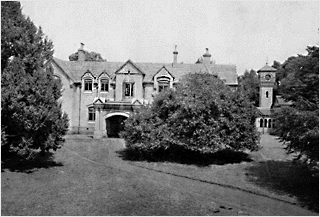 John Sullivan occupied the area by buying land from the native tribes people, often buying up many square kilometres in a day for the price of a few meals. In 1822, he began construction of the first house in the Nilgiris on a hillock in Ooty, to the east of the hollow where the racecourse now lies. In 1823 his wife, who had the distinction of being the first European woman in the Nilgiris, and his infant son moved into the house called Stonehouse
. Government House was soon built a few meters away. Stonehouse now serves as the administration building for the Government Arts College, which is the former Government House.
After the early 1820s, the hills were developed rapidly under the British Raj
because most of the land was by then privately owned by British citizens. It was a popular summer and weekend getaway for the British during the colonial days. In 1827 Ooty became the official sanatorium
and the summer capital of the Madras Presidency
. Many winding hill roads were built. In 1899, The Nilgiri Mountain Railway
was completed by influential and enterprising British citizens with venture capital from the Madras government.
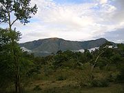
 Doddabetta
Peak, 4 km east south east from
Udhagamandalam,11°24′10"N 76°44′14"E, with a height of 2637 metres (8,652 ft) is the highest point in the Nilgiris and the southern extent of the range. . Hecuba (height: 2375 metres (7,792 ft)), Kattadadu (height: 2418 metres (7,933 ft)) and
Kulkudi (height: 2439 metres (8,002 ft)) are closely linked peaks in the west of Doddabetta range and nearby Udhagamandalam.
Snowdon (height: (2530 metres (8,301 ft)) 11°26′N 76°46′E is the northern extent of the range. Club Hill (height: 2448 metres (8,031 ft)) and Elk Hill (height: 2466 metres (8,091 ft)) 11°23′55"N 76°42′39"Eare significant elevations in this range. Snowdon, Club Hill and Elk Hill along with Doddabetta, form the impressive Udhagamandalam Valley.
Devashola (height: 2261 metres (7,418 ft)), notable for its Blue gum
trees, is in the south of Doddabetta range.
Kulakombai (height: 1707 metres (5,600 ft)) is east of the Devashola. The Bhavani Valley and the Lambton's peak range of Coimbatore district
stretch from here.
Hullikal Durg (height: 562 metres (1,844 ft)), 11°19′N 76°53′E in the Kannada language
, Hulikal Durg means Tiger Rock Fort. The Sanskrit name of his place is Bakasura Parvata. It is 3 km. south east of Coonoor
. Tropical Pine forest flourishes at the base of this hill, while the valleys support green foliage.
Coonoor Betta (2101 metres (6,893 ft)) is also called Teneriffe. It is on the northern side of the gorge, accommodating the Nilgiri Mountain Railway
to Coonoor.
Rallia Hill (height: 2248 metres (7,375 ft))11°25′N 76°53′E is in the midst of a reserved forest and almost equidistant from Udhagamandalam and Kotagiri
.
Dimhatti Hill (height: 1788 metres (5,866 ft)) 11°26′N 76°01′E is above the Gajalahatti pass, which provided a short cut from Mysore to the Carnatic plains
and was of much strategic importance in the eighteenth century. This peak, dedicated to the Deity Rangaswamy is considered holy by the people of the surrounding villages.
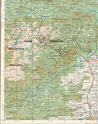
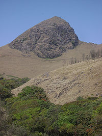
Nilgiris Peaks in Mukurthi National Park
On the Nilgiri Plateau, the Kundah range of the Nilgiri hills is a ridge on the south-western side of Mukurthi National Park bordering Kerala
. With elevations greater than the general level of the plateau, the range possesses some peaks close to the height of Doddabetta.
Avalanche hill of this range has the twin-peaks of Kudikkadu (height: 2590 metres (8,497 ft)) and Kolaribetta (height: 2625 metres (8,612 ft)).
Derbetta (or Bear Hill) (height: 2531 metres (8,304 ft)) and Kolibetta (height: 2494 metres (8,182 ft)), south of the Ouchterlony valley, are a continuation of the Kundah range.
 Mukurthi Peak 2554 metres (8,379 ft)) 11°23′29"N 76°31′38"E, Pichalbetta (height: 2544 metres (8,346 ft)) and Nilgiri Peak (height: 2474 metres (8,117 ft)) 11°24′0"N 76°30′4"E are the important heights of this area. These 3 hills of the Wayanad district
are generally low in relation to other heights of the district; but are distinguished in relation to the generally uniform level of this area.
Maruppanmudi hill (height: 1528 metres (5,013 ft)) 11°31′N 76°27′E is 10 km. northwest of Gudalur
.
Other heights deserving notice are: Needle Rock, Hadiabetta Hill (height: 1155 metres (3,789 ft)), Glulur hill (height: 1148 metres (3,766 ft)).
Chinna Doddabetta (height: 2392 metres (7,848 ft)) 11°28′N 76°45′E is about five km. south of Udhagamandalam.
 Konabetta: (height: 1880 metres (6,168 ft)) 11°30′N 76°46′E is about 5 km, north-northeast of Udhagamandalam. This is also called Sigur Peak.
Koodal Betta (height: 2183 metres (7,162 ft)) 11°28′N 76°50′E means Echoing rock. It is about 13 km north-east of Udhagamandalam.
Kundah Betta (height: 1998 metres (6,555 ft)) 11°07′N 76°43′E is About 10 km south-southwest of Udhagamandalam.
Kundah Mugi (height: 2344 metres (7,690 ft)) 11°24′N 76°51′E is about 11 km east of Udhagamandalam,
Dolphin's Nose 11°22′N 76°51′E is a promonotory over the Kotagiri valley about 6 km east-northeast of Coonoor. The place provides an excellent view of the Catherine falls
and a vast expanse of verdant plains.
Ibex Hill 11°27′N 76°35′E is about 17 km., west-southwest of Udhagamandalam. It is a straight cliff in the proximity of Sigur Pass.
Muttunadu Betta (height: 2323 metres (7,621 ft)) 11°27′N 76°43′E is about 5 km, north northwest of Udhagamandalam.
Tamrabetta (Coppery Hill) (height: 2120 metres (6,955 ft)) 11°22′N 76°48′E is about 8 km. south east of Udhagamandalam.
Vellangiri (Silvery Hill) (height: 2120 metres (6,955 ft)) is 16 km west-northwest of Udhagamandalam.
Rangaswamy Peak
rangaswamy Pillar
Kilkotagiri bettu
, near Kotagiri
, with a 250 feet (76.2 m) fall, named after the wife of M.D. Cockburn, believed to have introduced coffee plantations to the Nilgiri Hills. The Upper and Lower Pykara falls have falls of 180 feet (54.9 m), and 200 feet (61 m), respectively. The 170 feet (51.8 m) Kalhutti Fall is off the Segur Peak. The Karteri Fall, near Aruvankadu
had the first power station which supplied the original Cordite Factory with electricity. Law's Fall, near Coonoor
, is interesting due to its association with the engineer Major G. C. Law who supervised building of the Coonoor Ghat road.
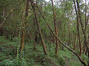 Over 2700 species of flowering plants, 160 species of fern and fern allies, countless types of flowerless plants, mosses, fungi, algae, land lichens are found in the sholas of the Nilgiris. No other Hill station has so many exotic species.
Much of the Nilgiris natural Montane grasslands and shrublands
interspersed with shola
s has been much disturbed or destroyed by extensive tea plantations, easy motor vehicle access and extensive commercial planting and harvesting of non-native eucalyptus
and wattle
plantations (Acacia dealbata
, Acacia mearnsii and cattle grazing. In addition there is one large, and several smaller hydro-electric impoundments in the area. Scotch broom has become an ecologically damaging invasive species
.
Threatened plants of the Nilgiris include the Vulnerable species
: Miliusa nilagirica
, Nothapodytes nimmoniana, Commelina wightii
and
Rare species
: Ceropegia decaisneana Ceropegia pusilla, Senecio kundaicus and endangered species: Youngia nilgiriensis
, Impatiens neo-barnesii, Impatiens nilagirica, Euonymus angulatus
and Euonymus serratifolius
.
 The Nilgiri hills can be reached by the Nilgiri Mountain Railway
and by motor vehicle over five separate Nilgiri Ghat Roads
.
A good way to enjoy the beauty of the Nilgiris is to trek its slopes. Some of the trekking routes are:
The best trekking seasons are April–June and September–December. Application for trekking permits should be made in advance with the Wildlife Warden, Mahalingam buildings, Coonoor Road, Udhagamandalam – 643 001 ; Phone: 0423- 2444098
The Tour of Nilgiris
is a week-long annual bicycling tour that traverses the Nilgiris mountains with the twin objectives of exploring the Nilgiris while promoting cycling
as an eco-friendly mode of transport and leisure.
Tamil Nadu
Tamil Nadu is one of the 28 states of India. Its capital and largest city is Chennai. Tamil Nadu lies in the southernmost part of the Indian Peninsula and is bordered by the union territory of Pondicherry, and the states of Kerala, Karnataka, and Andhra Pradesh...
state at the junction of Karnataka
Karnataka
Karnataka , the land of the Kannadigas, is a state in South West India. It was created on 1 November 1956, with the passing of the States Reorganisation Act and this day is annually celebrated as Karnataka Rajyotsava...
and Kerala
Kerala
or Keralam is an Indian state located on the Malabar coast of south-west India. It was created on 1 November 1956 by the States Reorganisation Act by combining various Malayalam speaking regions....
states in Southern India. They are part of the larger Western Ghats
Western Ghats
The Western Ghats, Western Ghauts or the Sahyādri is a mountain range along the western side of India. It runs north to south along the western edge of the Deccan Plateau, and separates the plateau from a narrow coastal plain along the Arabian Sea. The Western Ghats block rainfall to the Deccan...
mountain chain making up the southwestern edge of the Deccan Plateau
Deccan Plateau
The Deccan Plateau is a large plateau in India, making up the majority of the southern part of the country. It rises a hundred meters high in the north, rising further to more than a kilometers high in the south, forming a raised triangle nested within the familiar downward-pointing triangle of...
.
Location
The hills are separated from the Karnataka plateau to the north by the Moyar River and from the Anaimalai HillsAnaimalai Hills
The Anaimalai Hills is a range of mountains in the Western Ghats in Tamil Nadu and Kerala states of South India. The name "Anaimalai" derives from the Tamil word 'Ana' meaning elephant and 'Mala' meaning hill, thus Elephant Hill. The highest peak of the Anaimalai Hills is Anamudi, , located in the...
and Palni Hills
Palni Hills
The Palni Hills are a mountain range in Tamil Nadu state of South India. The Palni Hills are an eastward extension of the Western Ghats ranges, which run parallel to the west coast of India. The Palni Hills adjoin the high Anamalai range on the west, and extend east into the plains of Tamil Nadu,...
to the south by the Palghat Gap. The Nilgiris District of Tamil Nadu
Tamil Nadu
Tamil Nadu is one of the 28 states of India. Its capital and largest city is Chennai. Tamil Nadu lies in the southernmost part of the Indian Peninsula and is bordered by the union territory of Pondicherry, and the states of Kerala, Karnataka, and Andhra Pradesh...
lies within these mountains. Its latitudinal and longitudinal dimensions are 130 km (Latitude: 11° 08' to 11° 37' N) by 185 km (Longitude: 76° 27' E to 77° 4' E). Central location is: 11°22′30"N 76°45′30"E. It has an area of 2479 square kilometres (957.1 sq mi).
Conservation
The Western GhatsWestern Ghats
The Western Ghats, Western Ghauts or the Sahyādri is a mountain range along the western side of India. It runs north to south along the western edge of the Deccan Plateau, and separates the plateau from a narrow coastal plain along the Arabian Sea. The Western Ghats block rainfall to the Deccan...
, Nilgiri Sub-Cluster (6,000+ km²), including all of Mukurthi National Park
Mukurthi National Park
Mukurthi National Park is a 78.46 km² protected area located in the south-eastern corner of the Nilgiris Plateau west of Ootacamund hill station in the northwest corner of Tamil Nadu state in the Western Ghats mountain range of South India...
in the south-eastern corner of the Nilgiris, is under consideration by the UNESCO
UNESCO
The United Nations Educational, Scientific and Cultural Organization is a specialized agency of the United Nations...
World Heritage Committee for selection as a World Heritage Site
World Heritage Site
A UNESCO World Heritage Site is a place that is listed by the UNESCO as of special cultural or physical significance...
.
The Nilgiri Biosphere Reserve
Nilgiri Biosphere Reserve
The Nilgiri Biosphere Reserve is an International Biosphere Reserve in the Western Ghats, Nilgiri Hills range of South India. The Western Ghats, Nilgiri Sub-Cluster , conjoining the Nilgiri Biosphere Reserve, is under consideration by the UNESCO World Heritage Committee for selection as a World...
, which includes the Nilgiri Hills, is part of the UNESCO
UNESCO
The United Nations Educational, Scientific and Cultural Organization is a specialized agency of the United Nations...
World Network of Biosphere Reserves
World Network of Biosphere Reserves
The UNESCO World Network of Biosphere Reserves covers internationally-designated protected areas, known as biosphere reserves, that are meant to demonstrate a balanced relationship between man and nature The UNESCO World Network of Biosphere Reserves covers internationally-designated protected...
.
History
Vishnuvardhana
Vishnuvardhana was an emperor of the Hoysala Empire in present day Indian state of Karnataka. Vishnuvardhana took the first step in consolidating the Hoysala Empire in South India through a series of battles against his overlords, the Western Chalukya empire...
, King of Hoysalas, who in reference to his enemies, claimed to have “frightened the Todas
Toda people
The Toda people are a small pastoral community who live on the isolated Nilgiri plateau of Southern India. Before the late 18th century, the Toda coexisted locally with other communities, including the Badaga, Kota, and Kuruba, in a loose caste-like community organization in which the Toda were...
, driven the Kanga
Kanga
Kanga is the name of a recurring fictional character in A. A. Milne's series of books about Winnie-the-Pooh. A female kangaroo, Kanga is Roo's mother and a good friend to Winnie-the-Pooh and all the other residents of the Hundred Acre Wood. She lives with Roo in a house near the Sandy Pit in the...
s underground, slaughtered the Pallava
Pallava
The Pallava dynasty was a Tamil dynasty which ruled the northern Tamil Nadu region and the southern Andhra Pradesh region with their capital at Kanchipuram...
s, put to death the Malayala
Malayala Kshatriya
The Samanta Kshatriya are the topmost subdivision of the Malayala Kshatriya Community in Kerala, India. The Samanta Kshatriyas make up a part of the erstwhile royal families of the Hindu Kingdoms and princely states that existed in Kerala until the creation of the Indian Republic...
s, terrified King Kala
Kali
' , also known as ' , is the Hindu goddess associated with power, shakti. The name Kali comes from kāla, which means black, time, death, lord of death, Shiva. Kali means "the black one". Since Shiva is called Kāla - the eternal time, Kālī, his consort, also means "Time" or "Death" . Hence, Kāli is...
and then proceeded to offer the peak of Nila Mountain (presumably Dodabetta) to Lakshmi
Lakshmi
Lakshmi or Lakumi is the Hindu goddess of wealth, prosperity , light, wisdom, fortune, fertility, generosity and courage; and the embodiment of beauty, grace and charm. Representations of Lakshmi are also found in Jain monuments...
, Goddess of Wealth.
The original inhabitants
Adivasi
Adivasi is an umbrella term for a heterogeneous set of ethnic and tribal groups claimed to be the aboriginal population of India. They comprise a substantial indigenous minority of the population of India...
of the Nilgiri Hills were the Toda, Badaga, Kota, Irula and kurumbas. The Nilgiri Hills were part of Chera Empire in ancient times. Later, the area came under the rule of the Western Ganga Dynasty, and then Hoysala empire in the 12th century. They then became part of the Kingdom of Mysore
Kingdom of Mysore
The Kingdom of Mysore was a kingdom of southern India, traditionally believed to have been founded in 1399 in the vicinity of the modern city of Mysore. The kingdom, which was ruled by the Wodeyar family, initially served as a vassal state of the Vijayanagara Empire...
of Tipu Sultan
Tipu Sultan
Tipu Sultan , also known as the Tiger of Mysore, was the de facto ruler of the Kingdom of Mysore. He was the son of Hyder Ali, at that time an officer in the Mysorean army, and his second wife, Fatima or Fakhr-un-Nissa...
who later surrendered them to the British in the 18th century.
The first Europeans to attempt the grueling climb to the Nilgiris included an enigmatic Jesuit priest, Father Fininicio, in 1603. They struggled up the mountains, avoiding elephants, tigers and other wild beasts, and met the Todas at the top.
From 1799 these mountains were seen daily by the British authorities from the plains of Coimbatore
Coimbatore District
Coimbatore District is one of the more affluent and industrially advanced districts of the state of Tamil Nadu in India. Coimbatore is known as the Manchester of South India. It one of the most industrialized towns of Tamil Nadu. It has the highest GDP among the districts of Tamil Nadu, even ahead...
. Revenue was collected from them for the British East India Company
British East India Company
The East India Company was an early English joint-stock company that was formed initially for pursuing trade with the East Indies, but that ended up trading mainly with the Indian subcontinent and China...
by a native renter.
Excepting Dr. Ford and Capt. Bevan, who traversed the hills in 1809 with a party of pioneers, and some deputy surveyors under Colonel Monson, who partially mapped the area, no British had ventured to explore the all but unknown region.
In 1814, Mr, Keys, a sub-assistant, and Mr. McMahon, an apprentice in the Survey Department, ascended the hills by the Danaynkeucottah Pass, penetrated into the remotest parts, made plans, and sent in reports of their discoveries. As a result of these accounts, Messrs. Whish and Kindersley, two young Madras civilians, ventured up in pursuit of some
criminal's taking refuge in the mountains, and proceeded to reconnoitre the interior. They soon saw and felt
enough favorable climate and terrain to excite their own curiosity and that of others.
In 1819, John Sullivan
John Sullivan (British governor)
John Sullivan was the Collector of Coimbatore, India, who is best known as the founder of the town of Ooty.Born in London, he joined the British East India Company as a writer at the age of 15....
, the British Collector of Coimbatore, set out to explore the Nilgiris after obtaining an order from the British East India Company charging him to investigate the "origin of the fabulous tales that are circulated concerning the Blue Mountains to verify their authenticity and to send a report to the authorities".
With a detachment of Europeans and Indian sepoy
Sepoy
A sepoy was formerly the designation given to an Indian soldier in the service of a European power. In the modern Indian Army, Pakistan Army and Bangladesh Army it remains in use for the rank of private soldier.-Etymology and Historical usage:...
s, he set out on his mission on January 2, 1819. The journey involved crossing rough and harsh terrain, steep precipices and danger from wild animals. After an expedition that lasted for six days and loss of the lives of some of the expedition members, Sullivan finally reached a plateau from where he proudly hoisted the British flag.
In May, 1819, the same tourists from Coimbatore, accompanied by Monsieur Leschnault de la Tour, naturalist to the King of France, repeated their excursion. They asserted the temperature in the shade to be 74 °F (23.3 °C) at a time when the temperature of the plains was up to 100 °F (37.8 °C). Such a climate within the tropics was considered so great an anomaly that few at first believed its existence.
Stone House, Ooty
Stone House is the first bungalow constructed in Ooty. It was built by John Sullivan and was called as Kal Bangala by the tribals . Today, it is the official residence for the principal of the Government Arts College, Ooty...
. Government House was soon built a few meters away. Stonehouse now serves as the administration building for the Government Arts College, which is the former Government House.
After the early 1820s, the hills were developed rapidly under the British Raj
British Raj
British Raj was the British rule in the Indian subcontinent between 1858 and 1947; The term can also refer to the period of dominion...
because most of the land was by then privately owned by British citizens. It was a popular summer and weekend getaway for the British during the colonial days. In 1827 Ooty became the official sanatorium
Sanatorium
A sanatorium is a medical facility for long-term illness, most typically associated with treatment of tuberculosis before antibiotics...
and the summer capital of the Madras Presidency
Madras Presidency
The Madras Presidency , officially the Presidency of Fort St. George and also known as Madras Province, was an administrative subdivision of British India...
. Many winding hill roads were built. In 1899, The Nilgiri Mountain Railway
Nilgiri Mountain Railway
The Nilgiri Mountain Railway is a railway in Tamil Nadu, India, built by the British in 1908, and was initially operated by the Madras Railway Company. The railway still relies on its fleet of steam locomotives. NMR comes under the jurisdiction of the newly formed Salem Division...
was completed by influential and enterprising British citizens with venture capital from the Madras government.
Peaks in the Nilgiris
Doddabetta
Doddabetta is the highest mountain in the Nilgiri Hills, at 2637 metre . There is a reserved forest area around the peak. It is 9 km from Ooty,on Ooty-Kotagiri Road in the Nilgiris District of Tamil Nadu, South India...
Peak, 4 km east south east from
Udhagamandalam,11°24′10"N 76°44′14"E, with a height of 2637 metres (8,652 ft) is the highest point in the Nilgiris and the southern extent of the range. . Hecuba (height: 2375 metres (7,792 ft)), Kattadadu (height: 2418 metres (7,933 ft)) and
Kulkudi (height: 2439 metres (8,002 ft)) are closely linked peaks in the west of Doddabetta range and nearby Udhagamandalam.
Snowdon (height: (2530 metres (8,301 ft)) 11°26′N 76°46′E is the northern extent of the range. Club Hill (height: 2448 metres (8,031 ft)) and Elk Hill (height: 2466 metres (8,091 ft)) 11°23′55"N 76°42′39"Eare significant elevations in this range. Snowdon, Club Hill and Elk Hill along with Doddabetta, form the impressive Udhagamandalam Valley.
Devashola (height: 2261 metres (7,418 ft)), notable for its Blue gum
Blue Gum
Blue Gum usually refers to the subspecies or the species in Eucalyptus globulus complex, however it may also refer to a number of other species of Eucalyptus in Australia. Confusingly, in Queensland it usually refers to Eucalyptus tereticornis, which is known elsewhere as Forest Red Gum.* Gippsland...
trees, is in the south of Doddabetta range.
Kulakombai (height: 1707 metres (5,600 ft)) is east of the Devashola. The Bhavani Valley and the Lambton's peak range of Coimbatore district
Coimbatore District
Coimbatore District is one of the more affluent and industrially advanced districts of the state of Tamil Nadu in India. Coimbatore is known as the Manchester of South India. It one of the most industrialized towns of Tamil Nadu. It has the highest GDP among the districts of Tamil Nadu, even ahead...
stretch from here.
Hullikal Durg (height: 562 metres (1,844 ft)), 11°19′N 76°53′E in the Kannada language
Kannada language
Kannada or , is a language spoken in India predominantly in the state of Karnataka. Kannada, whose native speakers are called Kannadigas and number roughly 50 million, is one of the 30 most spoken languages in the world...
, Hulikal Durg means Tiger Rock Fort. The Sanskrit name of his place is Bakasura Parvata. It is 3 km. south east of Coonoor
Coonoor
Coonoor is a town and a municipality in the Nilgiris district in the state of Tamil Nadu, India. It is known for its production of Nilgiri tea....
. Tropical Pine forest flourishes at the base of this hill, while the valleys support green foliage.
Coonoor Betta (2101 metres (6,893 ft)) is also called Teneriffe. It is on the northern side of the gorge, accommodating the Nilgiri Mountain Railway
Nilgiri Mountain Railway
The Nilgiri Mountain Railway is a railway in Tamil Nadu, India, built by the British in 1908, and was initially operated by the Madras Railway Company. The railway still relies on its fleet of steam locomotives. NMR comes under the jurisdiction of the newly formed Salem Division...
to Coonoor.
Rallia Hill (height: 2248 metres (7,375 ft))11°25′N 76°53′E is in the midst of a reserved forest and almost equidistant from Udhagamandalam and Kotagiri
Kotagiri
Kotagiri is a panchayat town in The Nilgiris District in the Indian state of Tamil Nadu.Kotagiri is situated at an elevation of around 1793 m above sea level and is one of the three popular hill stations located in the Nilgiris...
.
Dimhatti Hill (height: 1788 metres (5,866 ft)) 11°26′N 76°01′E is above the Gajalahatti pass, which provided a short cut from Mysore to the Carnatic plains
Carnatic region
The Carnatic coast is the region of South India lying between the Eastern Ghats and the Coromandel Coast, in the modern Indian states of Tamil Nadu, south eastern Karnataka and southern Andhra Pradesh....
and was of much strategic importance in the eighteenth century. This peak, dedicated to the Deity Rangaswamy is considered holy by the people of the surrounding villages.
Nilgiris Peaks in Mukurthi National Park
Mukurthi National Park
Mukurthi National Park is a 78.46 km² protected area located in the south-eastern corner of the Nilgiris Plateau west of Ootacamund hill station in the northwest corner of Tamil Nadu state in the Western Ghats mountain range of South India...
On the Nilgiri Plateau, the Kundah range of the Nilgiri hills is a ridge on the south-western side of Mukurthi National Park bordering Kerala
Kerala
or Keralam is an Indian state located on the Malabar coast of south-west India. It was created on 1 November 1956 by the States Reorganisation Act by combining various Malayalam speaking regions....
. With elevations greater than the general level of the plateau, the range possesses some peaks close to the height of Doddabetta.
Avalanche hill of this range has the twin-peaks of Kudikkadu (height: 2590 metres (8,497 ft)) and Kolaribetta (height: 2625 metres (8,612 ft)).
Derbetta (or Bear Hill) (height: 2531 metres (8,304 ft)) and Kolibetta (height: 2494 metres (8,182 ft)), south of the Ouchterlony valley, are a continuation of the Kundah range.
Wayanad District
Wayanad District in the north-east of Kerala, India, was formed on November 1, 1980 as the 12th district by carving out areas from Kozhikode and Kannur districts. Kalpetta is the district headquarters as well as the only municipal town in the district. The region was known as Mayakshetra in the...
are generally low in relation to other heights of the district; but are distinguished in relation to the generally uniform level of this area.
Maruppanmudi hill (height: 1528 metres (5,013 ft)) 11°31′N 76°27′E is 10 km. northwest of Gudalur
Gudalur (Nilgiris district)
Gudalur , , , is a panchayat town and taluk in Nilgiris district in the Indian state of Tamil Nadu. It is said that Gudalur gets its name from Koodal + uru, meaning the Meeting Place.-Overview:...
.
Other heights deserving notice are: Needle Rock, Hadiabetta Hill (height: 1155 metres (3,789 ft)), Glulur hill (height: 1148 metres (3,766 ft)).
Chinna Doddabetta (height: 2392 metres (7,848 ft)) 11°28′N 76°45′E is about five km. south of Udhagamandalam.
Koodal Betta (height: 2183 metres (7,162 ft)) 11°28′N 76°50′E means Echoing rock. It is about 13 km north-east of Udhagamandalam.
Kundah Betta (height: 1998 metres (6,555 ft)) 11°07′N 76°43′E is About 10 km south-southwest of Udhagamandalam.
Kundah Mugi (height: 2344 metres (7,690 ft)) 11°24′N 76°51′E is about 11 km east of Udhagamandalam,
Dolphin's Nose 11°22′N 76°51′E is a promonotory over the Kotagiri valley about 6 km east-northeast of Coonoor. The place provides an excellent view of the Catherine falls
Catherine Falls
Catherine Falls is a double-cascaded waterfall located in Kotagiri, The Nilgiris District, Tamil nadu and It is also an major tourist spot in Kotagiri.It is on the Mettupalayam road branching off at Aravenu...
and a vast expanse of verdant plains.
Ibex Hill 11°27′N 76°35′E is about 17 km., west-southwest of Udhagamandalam. It is a straight cliff in the proximity of Sigur Pass.
Muttunadu Betta (height: 2323 metres (7,621 ft)) 11°27′N 76°43′E is about 5 km, north northwest of Udhagamandalam.
Tamrabetta (Coppery Hill) (height: 2120 metres (6,955 ft)) 11°22′N 76°48′E is about 8 km. south east of Udhagamandalam.
Vellangiri (Silvery Hill) (height: 2120 metres (6,955 ft)) is 16 km west-northwest of Udhagamandalam.
List of peaks in the Nilgiri Hills
| No. | Local name !! Height !! English name !! Location | |||
|---|---|---|---|---|
| 1 | Anginda peak Anginda peak Anginda peak is in the Nilgiri Hills of the Western Ghats in Kerala, South India. Its coordinate location is . It has an altitude is and is the highest peak in Silent Valley National Park.It is just south of Sispara pass, and forms the southernmost boundary of Mukurthi National Park in Tamil Nadu... |
2383 metres (7,818 ft) | 11°12′26"N 76°27′51"E | |
| 2 | Chinna Doddabetta | 2392 metres (7,848 ft) | ||
| 3 | C | 2448 metres (8,031 ft) | Club Hill | |
| 4 | Coonoor Betta | 2101 metres (6,893 ft) | Teneriffe | |
| 5 | Derbetta | 2531 metres (8,304 ft) | Bear Hill | |
| 6 | Devashola | 2261 metres (7,418 ft) | ||
| 7 | Dimhatti Hill | 1788 metres (5,866 ft) | 11°26′N 76°01′E | |
| 8 | Doddabetta Doddabetta Doddabetta is the highest mountain in the Nilgiri Hills, at 2637 metre . There is a reserved forest area around the peak. It is 9 km from Ooty,on Ooty-Kotagiri Road in the Nilgiris District of Tamil Nadu, South India... Peak |
2637 metres (8,652 ft) | 11°24′10"N 76°44′14"E |
|
| 9 | D | Dolphin's Nose | 11°22′09"N 76°51′33"E | |
| 10 | E | 2466 metres (8,091 ft) | Elk Hill | 11°23′55"N 76°42′39"E |
| 11 | Glulur hill | 1148 metres (3,766 ft) | 11°28′N 76°45′E | |
| 12 | Gulkal Malai | 2467.7 metres (8,096 ft) | 11°14′47"N 76°28′1"E | |
| 13 | Hadiabetta Hill | 1155 metres (3,789 ft) | ||
| 14 | Hecuba | 2375 metres (7,792 ft) | ||
| 15 | Hullikal Durg | 562 metres (1,844 ft) | Tiger Rock Fort | 11°19′N 76°53′E |
| 16 | I | Ibex Hill | 11°27′N 76°35′E | |
| 17 | Kattadadu | 2418 metres (7,933 ft) | ||
| 18 | Kolaribetta | 2625 metres (8,612 ft) | ||
| 19 | Kolibetta | 2494 metres (8,182 ft) | ||
| 20 | Konabetta | 2066 metres (6,778 ft) | Sigur Peak. | 11°30′N 76°46′E |
| 21 | Koodal Betta | 2183 metres (7,162 ft) | Echoing rock | 11°28′N 76°50′E |
| 22 | Kudikkadu | 2590 metres (8,497 ft) | Avalanche Hill | |
| 23 | Kulakombai | 1707 metres (5,600 ft) | ||
| 24 | Kulkudi | 2439 metres (8,002 ft) | ||
| 25 | Kundah Betta | 1998 metres (6,555 ft) | 11°07′N 76°43′E | |
| 26 | Kundah Mugi | 2344 metres (7,690 ft) | 11°24′N 76°51′E | |
| 27 | Muttunadu Betta | 2323 metres (7,621 ft) | ||
| 28 | Mukurthi Peak | 2554 metres (8,379 ft) | 11°23′29"N 76°31′38"E | |
| 29 | Maruppanmudi hill | 1528 metres (5,013 ft) | 11°31′N 76°27′E | |
| 30 | Nadugani Peak | 2320 metres (7,612 ft) | 11°13′48"N 76°27′37"E | |
| 31 | N | 1438 metres (4,718 ft) | Needle Rock | |
| 32 | Nilgiri Peak | 2474 metres (8,117 ft) | 11°24′0"N 76°30′4"E | |
| 33 | Pichalbetta | 2544 metres (8,346 ft) | ||
| 34 | R | 2248 metres (7,375 ft) | Rallia Hill | 11°25′N 76°53′E |
| 35 | S | 2530 metres (8,301 ft) | Snowdon | 11°25′27"N 76°43′45"E |
| 36 | Tamrabetta | 2120 metres (6,955 ft) | Coppery Hill | |
| 37 | Vellangiri | 2120 metres (6,955 ft) | Silvery Hill |
Rangaswamy Peak
rangaswamy Pillar
Kilkotagiri bettu
Waterfalls
The highest waterfall, Kolakambai Fall, north of Kolakambai hill, has an unbroken fall of 400 feet (121.9 m). Nearby is the 150 feet (45.7 m) Halashana falls Second is Catherine FallsCatherine Falls
Catherine Falls is a double-cascaded waterfall located in Kotagiri, The Nilgiris District, Tamil nadu and It is also an major tourist spot in Kotagiri.It is on the Mettupalayam road branching off at Aravenu...
, near Kotagiri
Kotagiri
Kotagiri is a panchayat town in The Nilgiris District in the Indian state of Tamil Nadu.Kotagiri is situated at an elevation of around 1793 m above sea level and is one of the three popular hill stations located in the Nilgiris...
, with a 250 feet (76.2 m) fall, named after the wife of M.D. Cockburn, believed to have introduced coffee plantations to the Nilgiri Hills. The Upper and Lower Pykara falls have falls of 180 feet (54.9 m), and 200 feet (61 m), respectively. The 170 feet (51.8 m) Kalhutti Fall is off the Segur Peak. The Karteri Fall, near Aruvankadu
Aruvankadu
Aruvankadu, is a small town located in The Nilgiris District, Tamil Nadu, India. It is located between Coonoor and Ooty on the NH 67, at distances 5 km and 12 km respectively. It houses the Cordite Factory, one of the 40 Indian Ordnance Factories. It is one of the oldest Defence Factories...
had the first power station which supplied the original Cordite Factory with electricity. Law's Fall, near Coonoor
Coonoor
Coonoor is a town and a municipality in the Nilgiris district in the state of Tamil Nadu, India. It is known for its production of Nilgiri tea....
, is interesting due to its association with the engineer Major G. C. Law who supervised building of the Coonoor Ghat road.
Flora
Much of the Nilgiris natural Montane grasslands and shrublands
Montane grasslands and shrublands
Montane grasslands and shrublands is a biome defined by the World Wildlife Fund. The biome includes high altitude grasslands and shrublands around the world....
interspersed with shola
Shola
Sholas are patches of stunted evergreen tropical and subtropical moist broadleaf forest found in valleys amid rolling grassland in the higher montane regions of South India. These patches of shola forest are found mainly in the valleys and are usually separated from one another by undulating...
s has been much disturbed or destroyed by extensive tea plantations, easy motor vehicle access and extensive commercial planting and harvesting of non-native eucalyptus
Eucalyptus
Eucalyptus is a diverse genus of flowering trees in the myrtle family, Myrtaceae. Members of the genus dominate the tree flora of Australia...
and wattle
Acacia
Acacia is a genus of shrubs and trees belonging to the subfamily Mimosoideae of the family Fabaceae, first described in Africa by the Swedish botanist Carl Linnaeus in 1773. Many non-Australian species tend to be thorny, whereas the majority of Australian acacias are not...
plantations (Acacia dealbata
Acacia dealbata
Acacia dealbata is a species of Acacia, native to southeastern Australia in New South Wales, Victoria, Tasmania, and the Australian Capital Territory.-Description:...
, Acacia mearnsii and cattle grazing. In addition there is one large, and several smaller hydro-electric impoundments in the area. Scotch broom has become an ecologically damaging invasive species
Invasive species
"Invasive species", or invasive exotics, is a nomenclature term and categorization phrase used for flora and fauna, and for specific restoration-preservation processes in native habitats, with several definitions....
.
Threatened plants of the Nilgiris include the Vulnerable species
Vulnerable species
On 30 January 2010, the IUCN Red List of Threatened Species identified 9694 Vulnerable species, subspecies and varieties, stocks and sub-populations.-References:...
: Miliusa nilagirica
Miliusa nilagirica
Miliusa nilagirica is a species of plant in the Annonaceae family. It is endemic to India.-Sources:* World Conservation Monitoring Centre 1998. . Downloaded on 22 August 2007....
, Nothapodytes nimmoniana, Commelina wightii
Commiphora wightii
Commiphora wightii is a flowering plant in the family Burseraceae. The guggul plant may be found from northern Africa to central Asia, but is most common in northern India...
and
Rare species
Rare species
A rare species is a group of organisms that are very uncommon or scarce. This designation may be applied to either a plant or animal taxon, and may be distinct from the term "endangered" or "threatened species" but not "extinct"....
: Ceropegia decaisneana Ceropegia pusilla, Senecio kundaicus and endangered species: Youngia nilgiriensis
Youngia nilgiriensis
Youngia nilgiriensis is an endangered perennial herb. It is endemic to the Sispara area of the Kundah range of the Nilgiri Hills, Tamil Nadu, South India characterised by vast stretches of grasslands interrupted by numerous sholas at an altitude of around . It is listed as an endangered species in...
, Impatiens neo-barnesii, Impatiens nilagirica, Euonymus angulatus
Euonymus angulatus
Euonymus angulatus is a species of plant in the Celastraceae family. It is endemic to India. It is threatened by habitat loss.-Source:* World Conservation Monitoring Centre 1998. . Downloaded on 21 August 2007....
and Euonymus serratifolius
Euonymus serratifolius
Euonymus serratifolius is a species of plant in the Celastraceae family. It is endemic to India.-Source:* World Conservation Monitoring Centre 1998. . Downloaded on 21 August 2007....
.
Visitor information
Nilgiri Mountain Railway
The Nilgiri Mountain Railway is a railway in Tamil Nadu, India, built by the British in 1908, and was initially operated by the Madras Railway Company. The railway still relies on its fleet of steam locomotives. NMR comes under the jurisdiction of the newly formed Salem Division...
and by motor vehicle over five separate Nilgiri Ghat Roads
Nilgiri Ghat Roads
Many Ghat Roads can be found in the Nilgiris District of Tamil Nadu, Southern India. Nearly all of the district is located in the Nilgiri Hills, part of the Western Ghats mountains. This area borders the states of Karnataka and Kerala. The hills consequently can be reached by road from three states...
.
A good way to enjoy the beauty of the Nilgiris is to trek its slopes. Some of the trekking routes are:
- Ooty, Parson's Valley, Porthimund, Nilgiri Wildlife and Environment AssociationNilgiri Wildlife and Environment AssociationThe Nilgiri Wildlife and Environmental Association is a non-governmental organization registered in Tamil Nadu state South India. Their objective is to conserve the wildlife, habitat and natural resources of the Nilgiri Hills....
hut (NWLEA), Mukurthi Peak, Mukurthi Dam, Ooty. - Ooty, Upper BhavaniUpper BhavaniUpper Bhavani is in The Nilgiris District, Tamil Nadu, India.Ooty to Upper Bhavani is a 60 km drive through the verdant green Nilgiris. Upper Bhavani serves as one of the get ways to the Mukurthi national park, 20 km from Avalanche and 10 km from Korakundah. Upper bhavani gets around...
, Emerald, Avalanche via Kolaribetta, Ooty. (Accommodation at Upper Bhavani Forest guest house) - Ooty, Western Catchment 2, via T.R. Bazaar, Nilgiri Peak, Mukurti Peak, Sispara Pass via Western Catchment-2 and 1, Bangitappal, Ooty.
- Ooty, Ebbanad, Segur, Anaikatti, Sirur, Theppakadu, Ooty.
- Ooty, PykaraPykaraPykara is a river located 19 km from Ooty in the Indian state of Tamil Nadu. The Pykara is considered very sacred by the Todas. The Pykara river rises at Mukurthi peak. It passes through hilly tract, generally keeping to North and turns to West after reaching the Plateau's edge...
, GlenmorganGlenmorganGlenmorgan is a rural village in the Australian state of Queensland. The village is located on Surat Developmental Road in the Western Downs Region local government area, west of the state capital, Brisbane...
, Singara (Hydro PowerStation), Mudumalai, Solur Village, Ooty. - Coonoor, Lamb's Rock, Lady Canning's SeatLady Canning's Seat, CoonoorLady Canning's Seat is major tourist spot in Coonoor, The Nilgiris, Tamil Nadu. It is situated 9 km from the township Coonoor and further along the same road as that to Lamb's Rock. This is a small mansion, which is surrounded by tea estates and plains, located in the middle of the...
, Dolphin's NoseDolphin's Nose, CoonoorDolphin's Nose Viewpoint is a tourist spot in Coonoor, The Nilgiris District, Tamil Nadu. Dolphin's Nose is well over 1,000 feet above sea level, 10 km from Coonoor and is a spectacular spot to visit. The tip of the peak resembles like a Dolphin Nose and so it is named as Dolphin's Nose....
, Law's FallsLaw's Falls, CoonoorLaw's Falls is a tourist spot in Coonoor, The Nilgiris, Tamil Nadu.It is a beautiful picnic spot, named after a man named Col. Law, the man behind the construction of the new Coonoor ghat. Law's Falls is a small waterfall located on the Coonoor river near its junction with the Mettupalayam Ghat...
, Droog FortDroog Fort, CoonoorDroog Fort is a tourist spot in Coonoor, The Nilgiris, Tamil Nadu. Droog Fort is also called by name of Bakasura Malai.It is situated only at a distance of 13 km from Coonoor, trekking must be undertaken to getting to this fort. This old and worn out fort approximate height is 6,000 ft...
.
The best trekking seasons are April–June and September–December. Application for trekking permits should be made in advance with the Wildlife Warden, Mahalingam buildings, Coonoor Road, Udhagamandalam – 643 001 ; Phone: 0423- 2444098
The Tour of Nilgiris
Tour of Nilgiris
The Tour of Nilgiris is India’s first and best organized Bicycle Tour.Billed as India's Longest Bike Ride, what makes this Tour more appealing is that this Tour is extremely well organized by professionals who share the vision of the ....
is a week-long annual bicycling tour that traverses the Nilgiris mountains with the twin objectives of exploring the Nilgiris while promoting cycling
Cycling
Cycling, also called bicycling or biking, is the use of bicycles for transport, recreation, or for sport. Persons engaged in cycling are cyclists or bicyclists...
as an eco-friendly mode of transport and leisure.
External links
- Rock Galleries, Frontline, Volume 24 - Issue 12 :: Jun. 16-29, 2007
- A Manual of the Nilagiri District in the Madras Presidency, 1880