

Pir Panjal Range
Encyclopedia
Himachal Pradesh
Himachal Pradesh is a state in Northern India. It is spread over , and is bordered by the Indian states of Jammu and Kashmir on the north, Punjab on the west and south-west, Haryana and Uttar Pradesh on the south, Uttarakhand on the south-east and by the Tibet Autonomous Region on the east...
and Kashmir
Kashmir
Kashmir is the northwestern region of the Indian subcontinent. Until the mid-19th century, the term Kashmir geographically denoted only the valley between the Great Himalayas and the Pir Panjal mountain range...
in India as well as Pakistan-administered Kashmir
Pakistan-administered Kashmir
Azad Kashmir borders the Pakistani provinces of Punjab and Khyber Pakhtunkhwa to the west, the Wakhan Corridor of Afghanistan to the north west, the Xinjiang Uyghur Autonomous Region of People's Republic of China to the north and the Indian-administered state of Jammu and Kashmir, to the east.A...
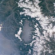
, where the average elevation varies from 1400 metres (4,593.2 ft) to 4100 metres (13,451.4 ft). The Himalayas show a gradual elevation towards the Dhauladhar and Pir Panjal ranges. Pir Panjal is the largest range of the lower Himalayas. Near the bank of the Sutlej river, it dissociates itself from the Himalayas and forms a divide between the rivers Beas and Ravi on one side and the Chenab on the other.
The Pir Panjal pass to the west of Srinagar, the Banihal pass (2739 metres (8,986.2 ft)) which lies at the head of the Jhelum river
Jhelum River
Jehlum River or Jhelum River , ) is a river that flows in India and Pakistan. It is the largest and most western of the five rivers of Punjab, and passes through Jhelum District...
at the southern end of the Kashmir valley, and the Sythen pass connecting Jammu and Kashmir with Kishtwar are some among the important passes in the region.
Rohtang La is a mountain pass
Mountain pass
A mountain pass is a route through a mountain range or over a ridge. If following the lowest possible route, a pass is locally the highest point on that route...
on the eastern Pir Panjal range connecting Manali in Kullu
Kullu
Kullu, once known as Kul-anti-peetha - "the end of the habitable world", is the capital town of the Kullu District, in the state of Himachal Pradesh, India. It is located on the banks of the Beas River in the Kullu Valley about ten kilometres north of the airport at Bhuntar.Kullu is a broad open...
Valley to Keylong
Keylong
Keylong is the administrative centre of the Lahaul and Spiti district in the Indian state of Himachal Pradesh, some 120 kilometres from the Indo-Tibetan border....
in Lahaul Valley. Haji Pir Pass is a mountain pass on the western Pir Panjal range between Poonch
Poonch
Poonch is a town and a municipal committee in Poonch District in the Indian state of Jammu and Kashmir. Based on the Mahābhārata evidence, and the evidence from 7th Chinese traveler Xuanzang, the districts of Poonch along with Rajauri and Abhisara had been under the sway of the Republican Kambojas...
and Uri
Úri
Úriis a village and commune in the comitatus of Pest in Hungary....
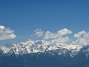
. Deo Tibba (6001 metres (19,688.3 ft)) and Indrasan (6221 metres (20,410.1 ft)) are two important peaks at the eastern end of the mountain range. They can be approached from both the Parvati
Parvati
Parvati is a Hindu goddess. Parvati is Shakti, the wife of Shiva and the gentle aspect of Mahadevi, the Great Goddess...
-Beas Valley (Kulu District) and the Chandra (Upper Chenab) Valley (Lahaul and Spiti District) in the Indian state of Himachal Pradesh. The hill station
Hill station
A hill station is a town located at a higher elevation than the nearby plain or valley. The term was used mostly in colonial Asia , but also in Africa , for towns founded by European colonial rulers as refuges from the summer heat, up where temperatures are cooler...
of Gulmarg
Gulmarg
Gulmarg is a town, a hill station and a notified area committee in Baramula district in the Indian state of Jammu and Kashmir.-Geography:Gulmarg is located 52 km from Srinagar. It is located at . It has an average elevation of .-Demographics:...
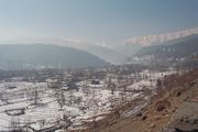
in Kashmir lies in this range.
Haji Pir Pass
Hajipir Pass is in the Pakistan-administered Kashmir area. It has been contested territory over many years, located on the road between Poonch and Uri at a height of 2637 metres (8,651.6 ft). The pass, and therefore the strategically significant road, was freed from the control of Pakistani forces and others connected to that country by the Indian ArmyIndian Army
The Indian Army is the land based branch and the largest component of the Indian Armed Forces. With about 1,100,000 soldiers in active service and about 1,150,000 reserve troops, the Indian Army is the world's largest standing volunteer army...
in 1947. It was later re-occupied by Pakistan, prior to the ceasefire of 1 January 1949, and control was retained until the 1965 war. At that time, India once again gained possession but only briefly, and the pass was returned as a consequence of the Tashkent Agreement.
Hajipir Pass remains a volatile area. Control of its heights means that Pakistani forces overlook the town of Poonch, while militants use it as a route into Kashmir and the Rajouri-Poonch areas. It is dominated by three hill features, namely: Bedori (3760 metres (12,336 ft) in the east, Sant (2895 metres (9,498 ft) in the west and Lediwali Gali (3140 metres (10,301.8 ft) in the south west. Control of the pass depends on control of these peaks.
Pir Panjal Railway Tunnel
Pir Panjal Railway Tunnel is a railway tunnel located in Pir Panjal Range of middle Himalayas in Jammu and Kashmir, India. It has been constructed by the Northern Railway, a division of Indian Railway as a part of its Udhampur-Srinagar-Baramulla rail link project. The boring of the tunnel was...
, the 10.96 Km long railway tunnel, passes through the Pir Panjal Range of middle Himalayas
Himalayas
The Himalaya Range or Himalaya Mountains Sanskrit: Devanagari: हिमालय, literally "abode of snow"), usually called the Himalayas or Himalaya for short, is a mountain range in Asia, separating the Indian subcontinent from the Tibetan Plateau...
in Jammu and Kashmir
Jammu and Kashmir
Jammu and Kashmir is the northernmost state of India. It is situated mostly in the Himalayan mountains. Jammu and Kashmir shares a border with the states of Himachal Pradesh and Punjab to the south and internationally with the People's Republic of China to the north and east and the...
. It is a part of its Udhampur
Udhampur
Udhampur is a city and a municipal council in Udhampur District in the Indian state of Jammu and Kashmir. It is the second lardest city of Duggardesh region and the fourth largest city in the state of Jammu and Kashmir. It serves as the district capital and the Northern Command headquarter of the...
- Srinagar - Baramulla
Baramulla
Baramulla , known as Varahamula in antiquity, is a city in the Baramulla district in Jammu and Kashmir state in northern India...
rail link project, opened in October 2011, India's longest and Asia
Asia
Asia is the world's largest and most populous continent, located primarily in the eastern and northern hemispheres. It covers 8.7% of the Earth's total surface area and with approximately 3.879 billion people, it hosts 60% of the world's current human population...
's second longest railway tunnel, which reduced the distance between Quazigund and Banihal
Banihal
Banihal is a town and a notified area committee in Doda district in Jammu and Kashmir, India. "Banihal" means blizzard in Kashmiri language.It has an average elevation of...
to only 11 km .