
.gif)
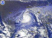
Cyclone 05B (1999)
Encyclopedia
The 1999 Orissa cyclone, also known as Cyclone 05B, and Paradip cyclone, was the deadliest Indian Ocean
tropical cyclone
since the 1991 Bangladesh cyclone
, and deadliest India
n storm since 1971. The Category Five storm made landfall just weeks after a Category 4 storm hit the same general area.
A tropical depression formed over the Malay Peninsula on October 25. It moved to the northwest and became a tropical storm on October 26. It continued to strengthen into a cyclone on October 27. On October 28, it became a severe cyclone with a peak of 160 mph (260 km/h) winds. It hit India the next day as a 155 mph (250 km/h) cyclone. It caused the deaths of 15,000 people, and heavy to extreme damage in its path of destruction.
in mid-to-late October. It tracked westward and organized itself enough to have the Joint Typhoon Warning Center
(JTWC) issue a Tropical Cyclone Formation Alert
(TCFA) on October 23. But the system failed to organize itself any further in the Pacific, and the TCFA was cancelled. When the system reached the Andaman Sea
on October 25, another TCFA was issued. Shortly after, the convective area consolidated, and it became Tropical Depression 5B on October 25 over the Malay Peninsula
. The depression tracked northwestward under the influence of the Subtropical ridge
to its north. Warm water temperatures and favorable upper level winds allowed further strengthening, and it became Tropical Storm 5B on October 26, 210 miles (345 km) south-southwest of Yangon
, Myanmar
.
The storm passed to the south of Myanmar
and continued to strengthen, and intensified to a cyclone on the 27th in the open Bay of Bengal
. On October 28, the cyclone rapidly intensified to a peak of 160 mph (260 km/h) winds, the equivalent of a Category 5 hurricane
. The system was the first storm to be given the new meteorological label "super cyclonic storm" by the IMD.
Just prior to its India
n landfall, the cyclone weakened slightly to a 155 mph (250 km/h) cyclone with an estimated minimum central pressure of <912 mbar. On October 29, the cyclone hit the Indian state of Orissa
near the city of Bhubaneswar
. The ridge to the north blocked further inland movement, and the cyclone stalled about 30 miles (50 km) inland of the ocean. It slowly weakened, maintaining tropical storm strength as it drifted southward. The cyclone re-emerged into the Bay of Bengal on October 31, and dissipated on November 3 over the open waters.
, Bhadrak
, Kendrapara
, Jagatsinghpur
, Puri
, and Ganjam
were forced to evacuate their homes before the storm's arrival. More than 44,500 people took shelter in twenty three Red Cross cyclone shelters. http://www.un.org.in/orissa.htm. Cuttack
and Khorda further inland were also severely affected.
 The cyclone dumped heavy torrential rain over southeast India, causing record breaking flooding in the low-lying areas. The storm surge
was 26 feet (8 meters). struck the coast of Orissa, traveling up to 20 km inland. 17,110 km² (6,600 mi²) of crops were destroyed, and an additional 90 million trees were either uprooted or had snapped.
Approximately 275,000 homes were destroyed, leaving 1.67 million people homeless. Another 19.5 million people were affected by the supercyclone to some degree. A total of 9,803 people officially died from the storm, with 40 others still missing, though it is believed that 15,000 people died. 8,119 of those fatalities were from the Jagatsinghpur
district. Another 3,312 people were injured. 2,043 out of 5,700, or 36% of the residents of Padmapur
perished. The number of domestic animals fatalities was around 2.5 million, though the number of livestock that perished in the cyclone amounted to only 406,000. The high number of domestic animal deaths may have possibly had to do with around 5 million farmers losing their livelihood. The damage across fourteen districts in India resulted from the storm was approximately $4.5 billion (1999 USD, $5.1 billion 2005 USD).
Ten people in Myanmar
were reported to have been killed by the tropical cyclone, while another 20,000 families were left homeless.
When Cyclone 05B reached its peak intensity of 912 mb, it became the most intense Tropical Cyclone of the North Indian Basin.
(IRCS) immediately responded with emergency relief, as did BAPS Care International (BAPSCI). The Orissa state branch extended the emergency relief phase to a three-month relief operation and a six-month rehabilitation program with the help of the Federation. The overall humanitarian response spanned well into the late 2000. The Orissa State Branch (OSB) immediately shipped emergency buffer stocks from the Indian Red Cross headquarters in New Delhi
. BAPSCI dispatched about 2,340 volunteers to 84 villages greatly affected by the storm. BAPSCI also cremated 700 bodies and buried 3,500 cattle carcasses because many people were superstitious about touching the dead bodies of those they did not know. Three villages were "adopted" by BAPSCI in January 2000 to rebuild, Chakulia
, Banipat, and Potak, all in Jagatsinghpur. A total of 200 concrete homes were constructed, as well as two concrete schools and two village tube-wells. The project was finally completed in May 2002, two and a half years after the cyclone hit. As of October 30, 1999, 50,000 people were evacuated from low-lying flooded areas on the coast of the Ganjam
and Jagatsinghpur
districts. More people on the coast of Paradeep were evacuated by the Orissa Government.
The Federation withdrew 200,000 CHF
from its Disaster Relief Emergency Fund to send to India, but the Indian Government refused the money, saying the cyclone was not a national disaster.
Many people died of starvation
and diseases after the storm, since rescue workers could not reach everyone in time.
Indian Ocean
The Indian Ocean is the third largest of the world's oceanic divisions, covering approximately 20% of the water on the Earth's surface. It is bounded on the north by the Indian Subcontinent and Arabian Peninsula ; on the west by eastern Africa; on the east by Indochina, the Sunda Islands, and...
tropical cyclone
Tropical cyclone
A tropical cyclone is a storm system characterized by a large low-pressure center and numerous thunderstorms that produce strong winds and heavy rain. Tropical cyclones strengthen when water evaporated from the ocean is released as the saturated air rises, resulting in condensation of water vapor...
since the 1991 Bangladesh cyclone
1991 Bangladesh cyclone
-External links:** from NIRAPAD disaster response organisation.**...
, and deadliest India
India
India , officially the Republic of India , is a country in South Asia. It is the seventh-largest country by geographical area, the second-most populous country with over 1.2 billion people, and the most populous democracy in the world...
n storm since 1971. The Category Five storm made landfall just weeks after a Category 4 storm hit the same general area.
A tropical depression formed over the Malay Peninsula on October 25. It moved to the northwest and became a tropical storm on October 26. It continued to strengthen into a cyclone on October 27. On October 28, it became a severe cyclone with a peak of 160 mph (260 km/h) winds. It hit India the next day as a 155 mph (250 km/h) cyclone. It caused the deaths of 15,000 people, and heavy to extreme damage in its path of destruction.
Meteorological history
A tropical disturbance developed in the South China SeaSouth China Sea
The South China Sea is a marginal sea that is part of the Pacific Ocean, encompassing an area from the Singapore and Malacca Straits to the Strait of Taiwan of around...
in mid-to-late October. It tracked westward and organized itself enough to have the Joint Typhoon Warning Center
Joint Typhoon Warning Center
The Joint Typhoon Warning Center is a joint United States Navy – United States Air Force task force located at the Naval Maritime Forecast Center in Pearl Harbor, Hawaii...
(JTWC) issue a Tropical Cyclone Formation Alert
Tropical Cyclone Formation Alert
A Tropical Cyclone Formation Alert is a bulletin released by the U.S. Navy-operated Joint Typhoon Warning Center in Honolulu, Hawaii or the Naval Maritime Forecast Center in Norfolk, Virginia, warning of the possibility of a tropical cyclone forming from a tropical disturbance that has been...
(TCFA) on October 23. But the system failed to organize itself any further in the Pacific, and the TCFA was cancelled. When the system reached the Andaman Sea
Andaman Sea
The Andaman Sea or Burma Sea is a body of water to the southeast of the Bay of Bengal, south of Burma, west of Thailand and east of the Andaman Islands, India; it is part of the Indian Ocean....
on October 25, another TCFA was issued. Shortly after, the convective area consolidated, and it became Tropical Depression 5B on October 25 over the Malay Peninsula
Malay Peninsula
The Malay Peninsula or Thai-Malay Peninsula is a peninsula in Southeast Asia. The land mass runs approximately north-south and, at its terminus, is the southern-most point of the Asian mainland...
. The depression tracked northwestward under the influence of the Subtropical ridge
Subtropical ridge
The subtropical ridge is a significant belt of high pressure situated around the latitudes of 30°N in the Northern Hemisphere and 30°S in the Southern Hemisphere. It is characterized by mostly calm winds, which acts to reduce air quality under its axis by causing fog overnight, and haze during...
to its north. Warm water temperatures and favorable upper level winds allowed further strengthening, and it became Tropical Storm 5B on October 26, 210 miles (345 km) south-southwest of Yangon
Yangon
Yangon is a former capital of Burma and the capital of Yangon Region . Although the military government has officially relocated the capital to Naypyidaw since March 2006, Yangon, with a population of over four million, continues to be the country's largest city and the most important commercial...
, Myanmar
Myanmar
Burma , officially the Republic of the Union of Myanmar , is a country in Southeast Asia. Burma is bordered by China on the northeast, Laos on the east, Thailand on the southeast, Bangladesh on the west, India on the northwest, the Bay of Bengal to the southwest, and the Andaman Sea on the south....
.
The storm passed to the south of Myanmar
Myanmar
Burma , officially the Republic of the Union of Myanmar , is a country in Southeast Asia. Burma is bordered by China on the northeast, Laos on the east, Thailand on the southeast, Bangladesh on the west, India on the northwest, the Bay of Bengal to the southwest, and the Andaman Sea on the south....
and continued to strengthen, and intensified to a cyclone on the 27th in the open Bay of Bengal
Bay of Bengal
The Bay of Bengal , the largest bay in the world, forms the northeastern part of the Indian Ocean. It resembles a triangle in shape, and is bordered mostly by the Eastern Coast of India, southern coast of Bangladesh and Sri Lanka to the west and Burma and the Andaman and Nicobar Islands to the...
. On October 28, the cyclone rapidly intensified to a peak of 160 mph (260 km/h) winds, the equivalent of a Category 5 hurricane
Saffir-Simpson Hurricane Scale
The Saffir–Simpson Hurricane Scale , or the Saffir–Simpson Hurricane Wind Scale , classifies hurricanes — Western Hemisphere tropical cyclones that exceed the intensities of tropical depressions and tropical storms — into five categories distinguished by the intensities of their sustained winds...
. The system was the first storm to be given the new meteorological label "super cyclonic storm" by the IMD.
Just prior to its India
India
India , officially the Republic of India , is a country in South Asia. It is the seventh-largest country by geographical area, the second-most populous country with over 1.2 billion people, and the most populous democracy in the world...
n landfall, the cyclone weakened slightly to a 155 mph (250 km/h) cyclone with an estimated minimum central pressure of <912 mbar. On October 29, the cyclone hit the Indian state of Orissa
Orissa
Orissa , officially Odisha since Nov 2011, is a state of India, located on the east coast of India, by the Bay of Bengal. It is the modern name of the ancient nation of Kalinga, which was invaded by the Maurya Emperor Ashoka in 261 BC. The modern state of Orissa was established on 1 April...
near the city of Bhubaneswar
Bhubaneswar
Bhubaneswar is the capital of the Indian state of Orissa, officially Odisha. The city has a long history of over 2000 years starting with Chedi dynasty who had Sisupalgarh near present-day Bhubaneswar as their capital...
. The ridge to the north blocked further inland movement, and the cyclone stalled about 30 miles (50 km) inland of the ocean. It slowly weakened, maintaining tropical storm strength as it drifted southward. The cyclone re-emerged into the Bay of Bengal on October 31, and dissipated on November 3 over the open waters.
Preparations
Tens of thousands of families from the coastal districts of BalasoreBalasore
Balasore is a strategically located city in the state of Orissa, about north of the state capital Bhubaneswar, in eastern India. It is the administrative headquarters of Balasore district. It is best known for Chandipur beach. It is also the site of the Indian Ballistic Missile Defense...
, Bhadrak
Bhadrak
Bhadrak is a city and a municipality in Bhadrak district in the state of Orissa, India.-Demographics: India census, Bhadrak had a population of 1,33,4000. Males constitute 52% of the population and females 48%. Bhadrak has an average literacy rate of 73.86, higher than the national average of...
, Kendrapara
Kendrapara
Kendrapara is a city and a municipality in Kendrapara district in the Indian state of Orissa. It is the headquarters of Kendrapara district.-Geography:Kendrapara is located at . It has an average elevation of...
, Jagatsinghpur
Jagatsinghpur
Jagatsinghapur is a town and a Municipality area in Jagatsinghpur district in the Indian state of Orissa. Jagatsingpur got the recognition of a district on 1 April 1994, which is situated at a distance of 60 km from Cuttack. Jagtsingpur district has made Orissa's literature and culture...
, Puri
Puri
Puri is district headquarter, a city situated about south of state capital Bhubaneswar, on the eastern coast of the Bay of Bengal in the Indian state of Orissa. It is also known as Jagannath Puri after the Jagannath Temple . It is a holy city of the Hindus as a part of the Char Dham pilgrimages...
, and Ganjam
Ganjam
Ganjam is a town and a notified area committee in Ganjam district in the state of Orissa, India.-Geography:Ganjam is located at . It has an average elevation of 3 metres .-Demographics:...
were forced to evacuate their homes before the storm's arrival. More than 44,500 people took shelter in twenty three Red Cross cyclone shelters. http://www.un.org.in/orissa.htm. Cuttack
Cuttack
Cuttack is the former capital of the state of Orissa, India. It is the headquarters of Cuttack district and is located about 20 km to the north east of Bhubaneswar, the capital of Orissa. The name of the city is an anglicised form of Kataka that literally means The Fort, a reference to the...
and Khorda further inland were also severely affected.
Impact and Records
Storm surge
A storm surge is an offshore rise of water associated with a low pressure weather system, typically tropical cyclones and strong extratropical cyclones. Storm surges are caused primarily by high winds pushing on the ocean's surface. The wind causes the water to pile up higher than the ordinary sea...
was 26 feet (8 meters). struck the coast of Orissa, traveling up to 20 km inland. 17,110 km² (6,600 mi²) of crops were destroyed, and an additional 90 million trees were either uprooted or had snapped.
Approximately 275,000 homes were destroyed, leaving 1.67 million people homeless. Another 19.5 million people were affected by the supercyclone to some degree. A total of 9,803 people officially died from the storm, with 40 others still missing, though it is believed that 15,000 people died. 8,119 of those fatalities were from the Jagatsinghpur
Jagatsinghpur
Jagatsinghapur is a town and a Municipality area in Jagatsinghpur district in the Indian state of Orissa. Jagatsingpur got the recognition of a district on 1 April 1994, which is situated at a distance of 60 km from Cuttack. Jagtsingpur district has made Orissa's literature and culture...
district. Another 3,312 people were injured. 2,043 out of 5,700, or 36% of the residents of Padmapur
Padmapur
Padmapur is a town and a notified area committee in Bargarh district in the Indian state of Orissa.-Geography:Padmapur is located at . It has an average elevation of 205 metres .-Demographics:...
perished. The number of domestic animals fatalities was around 2.5 million, though the number of livestock that perished in the cyclone amounted to only 406,000. The high number of domestic animal deaths may have possibly had to do with around 5 million farmers losing their livelihood. The damage across fourteen districts in India resulted from the storm was approximately $4.5 billion (1999 USD, $5.1 billion 2005 USD).
Ten people in Myanmar
Myanmar
Burma , officially the Republic of the Union of Myanmar , is a country in Southeast Asia. Burma is bordered by China on the northeast, Laos on the east, Thailand on the southeast, Bangladesh on the west, India on the northwest, the Bay of Bengal to the southwest, and the Andaman Sea on the south....
were reported to have been killed by the tropical cyclone, while another 20,000 families were left homeless.
When Cyclone 05B reached its peak intensity of 912 mb, it became the most intense Tropical Cyclone of the North Indian Basin.
Aftermath
Indian Red Cross SocietyIndian Red Cross Society
Indian Red Cross Society is a voluntary humanitarian organization that provides emergency assistance, disaster relief, medical services, and education to raise awareness regarding health related issues in India. It is the designated Indian affiliate of the International Red Cross and Red Crescent...
(IRCS) immediately responded with emergency relief, as did BAPS Care International (BAPSCI). The Orissa state branch extended the emergency relief phase to a three-month relief operation and a six-month rehabilitation program with the help of the Federation. The overall humanitarian response spanned well into the late 2000. The Orissa State Branch (OSB) immediately shipped emergency buffer stocks from the Indian Red Cross headquarters in New Delhi
New Delhi
New Delhi is the capital city of India. It serves as the centre of the Government of India and the Government of the National Capital Territory of Delhi. New Delhi is situated within the metropolis of Delhi. It is one of the nine districts of Delhi Union Territory. The total area of the city is...
. BAPSCI dispatched about 2,340 volunteers to 84 villages greatly affected by the storm. BAPSCI also cremated 700 bodies and buried 3,500 cattle carcasses because many people were superstitious about touching the dead bodies of those they did not know. Three villages were "adopted" by BAPSCI in January 2000 to rebuild, Chakulia
Chakulia
Chakulia is a city and a notified area in Purbi Singhbhum district in the state of Jharkhand, India.-Geography:Chakulia is located at . It has an average elevation of 115 metres .-History:...
, Banipat, and Potak, all in Jagatsinghpur. A total of 200 concrete homes were constructed, as well as two concrete schools and two village tube-wells. The project was finally completed in May 2002, two and a half years after the cyclone hit. As of October 30, 1999, 50,000 people were evacuated from low-lying flooded areas on the coast of the Ganjam
Ganjam
Ganjam is a town and a notified area committee in Ganjam district in the state of Orissa, India.-Geography:Ganjam is located at . It has an average elevation of 3 metres .-Demographics:...
and Jagatsinghpur
Jagatsinghpur
Jagatsinghapur is a town and a Municipality area in Jagatsinghpur district in the Indian state of Orissa. Jagatsingpur got the recognition of a district on 1 April 1994, which is situated at a distance of 60 km from Cuttack. Jagtsingpur district has made Orissa's literature and culture...
districts. More people on the coast of Paradeep were evacuated by the Orissa Government.
The Federation withdrew 200,000 CHF
Swiss franc
The franc is the currency and legal tender of Switzerland and Liechtenstein; it is also legal tender in the Italian exclave Campione d'Italia. Although not formally legal tender in the German exclave Büsingen , it is in wide daily use there...
from its Disaster Relief Emergency Fund to send to India, but the Indian Government refused the money, saying the cyclone was not a national disaster.
Many people died of starvation
Starvation
Starvation is a severe deficiency in caloric energy, nutrient and vitamin intake. It is the most extreme form of malnutrition. In humans, prolonged starvation can cause permanent organ damage and eventually, death...
and diseases after the storm, since rescue workers could not reach everyone in time.
See also
- Tropical cycloneTropical cycloneA tropical cyclone is a storm system characterized by a large low-pressure center and numerous thunderstorms that produce strong winds and heavy rain. Tropical cyclones strengthen when water evaporated from the ocean is released as the saturated air rises, resulting in condensation of water vapor...
- List of tropical cyclones
- KathantaraKathantaraKathantara , is a 2005 Indian Oriya film directed by Himansu Khatua, a story of tribulations of 1999 Orissa cyclone. Much before the Tsunami became a household name all over the world, the coastal belts of Orissa were hit by what has come to be known as the Super Cyclone that killed more than...
- A film related to this cyclone