The
trade winds (also called
trades) are the
prevailing patternIn meteorology, prevailing winds are winds that blow predominantly from a single general direction over a particular point on the Earth's surface. The dominant winds are the trends in direction of wind with the highest speed over a particular point on the Earth's surface...
of
easterly
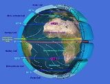
The easterlies commonly refer to the low latitude trade winds near the equator . These winds carry tropical waves and cyclones from east to west in lower latitudes...
surface
windWind is the flow of air or other gases that compose an atmosphere . On Earth, wind consists of the bulk movement of air...
s found in the
tropicsThe tropics,the tropics are very hot. hi everyone! peace out!seated in the equatorial regions of the world, are limited in latitude by the Tropic of Cancer in the northern hemisphere at approximately 23°26' N latitude and the Tropic of Capricorn in the southern hemisphere at 23°26' S latitude...
near the Earth's
equatorThe equator is the intersection of the Earth's surface with the plane perpendicular to the Earth's axis of rotation and containing the Earth's center of mass. In simpler language, it is an imaginary line on the Earth's surface equidistant from the North Pole and South Pole that divides the Earth...
. The trade winds blow predominantly from the northeast in the
Northern HemisphereThe Northern Hemisphere is the half of a planet that is north of the equator—the word hemisphere literally means 'half sphere'. It is also that half of the celestial sphere north of the celestial equator...
and from the southeast in the
Southern HemisphereThe Southern Hemisphere is the half of a planet that is south of the equator—the word hemisphere literally means 'half ball'...
. The trade winds act as the steering flow for tropical storms that form over the
AtlanticThe Atlantic Ocean is the second-largest of the world's oceanic divisions. With a total area of about 106.4 million square kilometres , it covers approximately one-fifth of the Earth's surface and about one-quarter of its water surface area. The first part of its name refers to the Atlas of Greek...
, Pacific, and
Indian OceanThe Indian Ocean is the third largest of the world's oceanic divisions, covering about 20% of the water on the Earth's surface. It is bounded on the north by South Asia ; on the west by Africa; on the east by Indochina, the Sunda Islands, and Australia; and on the south by the Southern Ocean...
s that make landfall in North America, Southeast Asia, and India, respectively. Trade winds also steer African dust westward across the
Atlantic oceanThe Atlantic Ocean is the second-largest of the world's oceanic divisions. With a total area of about 106.4 million square kilometres , it covers approximately one-fifth of the Earth's surface and about one-quarter of its water surface area. The first part of its name refers to the Atlas of Greek...
into the
Caribbean seaThe Caribbean Sea is a sea of the Atlantic Ocean situated in the tropics of the Western hemisphere, bounded to the south and west by the American landmass, with the North Atlantic Ocean proper to the northeast and the Gulf of Mexico to the northwest...
, as well as portions of southeast
North AmericaNorth America is the northern continent of the Americas, situated in the Earth's northern hemisphere and in the western hemisphere. It is bordered on the north by the Arctic Ocean, on the east by the North Atlantic Ocean, on the southeast by the Caribbean Sea, and on the west by the North Pacific...
.
Etymology
Their name originally derives from the late
Middle EnglishMiddle English is the name given by historical linguists to the diverse forms of the English language in use between the late 11th century and about 1470, when the Chancery Standard, a form of London-based English, began to become widespread, a process aided by the introduction of the printing...
word 'trade' (borrowed from
Middle Low GermanMiddle Low German is a language that is the descendant of Old Saxon and is the ancestor of modern Low German. It served as the international lingua franca of the Hanseatic League...
, and cognate with English 'tread'), meaning "path" or "track," and thence the obsolete nautical phrase "the wind blows trade," that is to say, on a consistent track. However, by the 18th century, because of the importance of these winds to England's merchant fleet crossing the Atlantic Ocean, both etymologists and the general public had come to identify them with a later meaning of 'trade', "(foreign) commerce". For relation to European shipping and exploration see
Winds in the Age of SailThe captain of a steam ship takes the shortest distance between two points. The captain of a sail ship seeks a course along which the winds can be expected to blow in the right direction...
.
Origin of the winds
The surface air flows toward the equator while the flow aloft is poleward. A low-pressure area of calm, light variable winds near the equator is known to mariners as the
doldrumsThe Doldrums, also called the "equatorial calms", is a nautical term for the equatorial trough, with special reference to the light and variable nature of the winds. It affects areas of the Atlantic Ocean, the Pacific Ocean and the Indian Ocean that are within the Intertropical Convergence Zone, a...
and climatologists as the
Intertropical Convergence ZoneThe Intertropical Convergence Zone is a term that is used to describe the North-East and South-East trade wind convergence. Convectively active portions of the ITCZ are known as the monsoon trough...
. Around 30° in both hemispheres air begins to descend toward the surface in subtropical high-pressure belts. The sinking air is relatively dry because its moisture has already been released near the equator.
The surface air that flows from these subtropical high-pressure belts toward the Equator is deflected toward the west in both hemispheres by the
Coriolis effectIn physics, the Coriolis effect is an apparent deflection of moving objects when they are viewed from a rotating reference frame.Newton's laws of motion govern the motion of an object in an inertial frame of reference. When transforming Newton's laws to a rotating frame of reference, the Coriolis...
. Because winds are named for the direction from which the wind is blowing, these winds are called the northeast trade winds in the Northern Hemisphere and the southeast trade winds in the Southern Hemisphere. The trade winds meet at the doldrums. Surface winds known as "
westerliesThe Westerlies or the Prevailing Westerlies are the prevailing winds in the middle latitudes between 35 and 65 degrees latitude, blowing from the high pressure area in the horse latitudes towards the poles. These prevailing winds blow from the west to the east, and steer extratropical cyclones in...
" flow from the
Horse latitudesHorse latitudes or Subtropical High are subtropic latitudes between 30 and 35 degrees both north and south. This region, under a ridge of high pressure called the subtropical high, is an area which receives little precipitation and has variable winds mixed with calm.The term horse latitudes...
toward the poles. The "westerlies" meet "easterlies" from the polar highs at about 50-60° N. and S.
Among the most well known trade winds is the
alizé (sometimes
alize), a steady, mild northeasterly wind which blows across central
AfricaAfrica is the world's second-largest and second most-populous continent, after Asia. At about 30.2 million km² including adjacent islands, it covers 6% of the Earth's total surface area and 20.4% of the total land area. With a billion people in 61 territories, it accounts for about 14.8% of the...
and the
CaribbeanThe Caribbean is a region consisting of the Caribbean Sea, its islands , and the surrounding coasts...
. It brings cool temperatures between November and February.
Trade winds are known to blow across Madagascar and other regions in the area. They are usually strongest between April and October, but they blow all year long.
Impact on Saharan dust migration
During mid-summer (July), the westward-moving trade winds south of the northward-moving
subtropical ridgeThe subtropical ridge is a large belt of high pressure situated around the latitudes of 30°N in the Northern Hemisphere and 30°S in the Southern Hemisphere. It is characterized by mostly calm winds, which acts to reduce air quality under its axis by causing fog overnight, and haze during daylight...
expand northwestward from the
Caribbean seaThe Caribbean Sea is a sea of the Atlantic Ocean situated in the tropics of the Western hemisphere, bounded to the south and west by the American landmass, with the North Atlantic Ocean proper to the northeast and the Gulf of Mexico to the northwest...
into southeastern North America. When dust from the
SaharaThe Sahara , , "The Greatest Desert") is the world's largest hot desert. At over 9,000,000 square kilometres , it covers most of Northern Africa, making it almost as large as the United States or the continent of Europe. The desert stretches from the Red Sea, including parts of the Mediterranean...
moving around the southern periphery of the ridge moves over land, rainfall is suppressed and the sky changes from a blue to a white appearance which leads to an increase in red sunsets. Its presence negatively impacts air quality by adding to the count of airborne particulates. Over 50% of the African dust that reaches the United States affects Florida. Since 1970, dust outbreaks have worsened due to periods of drought in Africa. There is a large variability in the dust transport to the Caribbean and Florida from year to year. Dust events have been linked to a decline in the health of
coral reefCoral reefs are aragonite structures produced by living organisms, found in marine waters containing few nutrients. In most reefs, the predominant organisms are stony corals, colonial cnidarians that secrete an exoskeleton of calcium carbonate...
s across the Caribbean and Florida, primarily since the 1970s.