
Snake River
Encyclopedia
- This article is about the river in the northwestern USA. For other uses, see Snake River (disambiguation)Snake River (disambiguation)The best-known Snake River is a tributary of the Columbia River in the United States.Snake River may also refer to:-Rivers:In Canada*Snake River , tributary of the Ottawa River in Ontario...
.
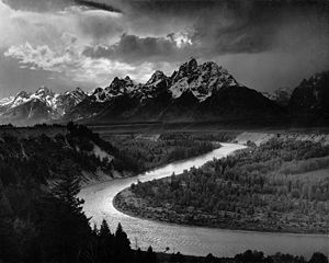
The Snake is a major river of the greater Pacific Northwest
Pacific Northwest
The Pacific Northwest is a region in northwestern North America, bounded by the Pacific Ocean to the west and, loosely, by the Rocky Mountains on the east. Definitions of the region vary and there is no commonly agreed upon boundary, even among Pacific Northwesterners. A common concept of the...
in the United States
United States
The United States of America is a federal constitutional republic comprising fifty states and a federal district...
. At 1078 miles (1,734.9 km) long, it is the largest tributary of the Columbia River
Columbia River
The Columbia River is the largest river in the Pacific Northwest region of North America. The river rises in the Rocky Mountains of British Columbia, Canada, flows northwest and then south into the U.S. state of Washington, then turns west to form most of the border between Washington and the state...
, the largest North American river that empties into the Pacific Ocean
Pacific Ocean
The Pacific Ocean is the largest of the Earth's oceanic divisions. It extends from the Arctic in the north to the Southern Ocean in the south, bounded by Asia and Australia in the west, and the Americas in the east.At 165.2 million square kilometres in area, this largest division of the World...
. Rising in western Wyoming
Wyoming
Wyoming is a state in the mountain region of the Western United States. The western two thirds of the state is covered mostly with the mountain ranges and rangelands in the foothills of the Eastern Rocky Mountains, while the eastern third of the state is high elevation prairie known as the High...
, the river flows through the Snake River Plain
Snake River Plain
The Snake River Plain is a geologic feature located primarily within the state of Idaho in the United States of America. It stretches about westward from northwest of the state of Wyoming to the Idaho-Oregon border. The plain is a wide flat bow-shaped depression, and covers about a quarter of Idaho...
then rugged Hells Canyon
Hells Canyon
Hells Canyon is a wide canyon located along the border of eastern Oregon and western Idaho in the United States. It is North America's deepest river gorge at and part of the Hells Canyon National Recreation Area....
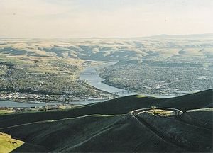
and the rolling Palouse Hills to reach its mouth at the Tri-Cities
Tri-Cities, Washington
The Tri-Cities is a mid-sized metropolitan area in the southeastern part of the U.S. state of Washington, consisting of three neighboring cities: Kennewick, Pasco, and Richland. The cities are located at the confluence of the Yakima, Snake, and Columbia rivers in the semi-arid region of...
of the state of Washington. Its drainage basin
Drainage basin
A drainage basin is an extent or an area of land where surface water from rain and melting snow or ice converges to a single point, usually the exit of the basin, where the waters join another waterbody, such as a river, lake, reservoir, estuary, wetland, sea, or ocean...
encompasses parts of six U.S. state
U.S. state
A U.S. state is any one of the 50 federated states of the United States of America that share sovereignty with the federal government. Because of this shared sovereignty, an American is a citizen both of the federal entity and of his or her state of domicile. Four states use the official title of...
s, and its average discharge
Discharge (hydrology)
In hydrology, discharge is the volume rate of water flow, including any suspended solids , dissolved chemical species and/or biologic material , which is transported through a given cross-sectional area...
is over 54000 cuft/s.
Rugged mountains divided by rolling plains characterize the physiographically diverse watershed of the Snake River. The Snake River Plain was created by a volcanic hotspot
Hotspot (geology)
The places known as hotspots or hot spots in geology are volcanic regions thought to be fed by underlying mantle that is anomalously hot compared with the mantle elsewhere. They may be on, near to, or far from tectonic plate boundaries. There are two hypotheses to explain them...
which now lies underneath Yellowstone National Park
Yellowstone National Park
Yellowstone National Park, established by the U.S. Congress and signed into law by President Ulysses S. Grant on March 1, 1872, is a national park located primarily in the U.S. state of Wyoming, although it also extends into Montana and Idaho...
, the headwaters of the Snake River. Gigantic glacial-retreat flooding episodes that occurred during the previous Ice Age
Ice age
An ice age or, more precisely, glacial age, is a generic geological period of long-term reduction in the temperature of the Earth's surface and atmosphere, resulting in the presence or expansion of continental ice sheets, polar ice sheets and alpine glaciers...
carved out many topographical features including various canyons and ridges along the middle and lower Snake. Two of these catastrophic flooding events significantly affected the river and its surrounds.
More than 11,000 years ago, prehistoric Native American
Indigenous peoples of the Americas
The indigenous peoples of the Americas are the pre-Columbian inhabitants of North and South America, their descendants and other ethnic groups who are identified with those peoples. Indigenous peoples are known in Canada as Aboriginal peoples, and in the United States as Native Americans...
s lived along the Snake. Salmon
Salmon
Salmon is the common name for several species of fish in the family Salmonidae. Several other fish in the same family are called trout; the difference is often said to be that salmon migrate and trout are resident, but this distinction does not strictly hold true...
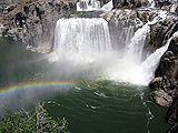
from the Pacific Ocean spawned in the millions in the river. These fish were central to the lives of the people along the Snake below Shoshone Falls
Shoshone Falls
Shoshone Falls is a waterfall on the Snake River located approximately five miles east of Twin Falls, Idaho. Sometimes called the "Niagara of the West," Shoshone Falls is 212 feet high—45 feet higher than Niagara Falls—and flows over a rim 1,000 feet wide.A park overlooking the waterfall is...
. By the time Lewis and Clark
Lewis and Clark Expedition
The Lewis and Clark Expedition, or ″Corps of Discovery Expedition" was the first transcontinental expedition to the Pacific Coast by the United States. Commissioned by President Thomas Jefferson and led by two Virginia-born veterans of Indian wars in the Ohio Valley, Meriwether Lewis and William...
crossed the Rockies and sighted the valley of a Snake tributary, the Nez Perce and Shoshone
Shoshone
The Shoshone or Shoshoni are a Native American tribe in the United States with three large divisions: the Northern, the Western and the Eastern....
were the most powerful people in the region. Contact with Europeans introduced horse
Horse
The horse is one of two extant subspecies of Equus ferus, or the wild horse. It is a single-hooved mammal belonging to the taxonomic family Equidae. The horse has evolved over the past 45 to 55 million years from a small multi-toed creature into the large, single-toed animal of today...
s to some tribes, reshaping their lifestyles for the next few hundred years before outside settlement. Later explorers and fur trappers further changed and utilized the resources of the Snake River basin. At one point, a hand sign made by the Shoshones representing fish was misinterpreted to represent a snake
Snake
Snakes are elongate, legless, carnivorous reptiles of the suborder Serpentes that can be distinguished from legless lizards by their lack of eyelids and external ears. Like all squamates, snakes are ectothermic, amniote vertebrates covered in overlapping scales...
, giving the Snake River its name.
By the middle 19th century, the Oregon Trail
Oregon Trail
The Oregon Trail is a historic east-west wagon route that connected the Missouri River to valleys in Oregon and locations in between.After 1840 steam-powered riverboats and steamboats traversing up and down the Ohio, Mississippi and Missouri rivers sped settlement and development in the flat...
, a pioneer trail of which a major portion followed the Snake River, had been established. Steamboat
Steamboat
A steamboat or steamship, sometimes called a steamer, is a ship in which the primary method of propulsion is steam power, typically driving propellers or paddlewheels...
s and railroads moved agricultural products and minerals along the river throughout the 19th and early 20th centuries. The powerful, steep flow of the Snake has been utilized since the 1890s to generate hydroelectricity
Hydroelectricity
Hydroelectricity is the term referring to electricity generated by hydropower; the production of electrical power through the use of the gravitational force of falling or flowing water. It is the most widely used form of renewable energy...
, enhance navigation and provide irrigation water from fifteen major dam
Dam
A dam is a barrier that impounds water or underground streams. Dams generally serve the primary purpose of retaining water, while other structures such as floodgates or levees are used to manage or prevent water flow into specific land regions. Hydropower and pumped-storage hydroelectricity are...
s that have transformed the lower river into a series of reservoir
Reservoir
A reservoir , artificial lake or dam is used to store water.Reservoirs may be created in river valleys by the construction of a dam or may be built by excavation in the ground or by conventional construction techniques such as brickwork or cast concrete.The term reservoir may also be used to...
s, several of which have been proposed for removal to restore some of the river's once tremendous salmon runs.
Course
Formed by the confluence of three tiny headstreams on the southwest flank of Two Oceans Plateau in western WyomingWyoming
Wyoming is a state in the mountain region of the Western United States. The western two thirds of the state is covered mostly with the mountain ranges and rangelands in the foothills of the Eastern Rocky Mountains, while the eastern third of the state is high elevation prairie known as the High...
and Yellowstone National Park
Yellowstone National Park
Yellowstone National Park, established by the U.S. Congress and signed into law by President Ulysses S. Grant on March 1, 1872, is a national park located primarily in the U.S. state of Wyoming, although it also extends into Montana and Idaho...
, the Snake starts out as a small river flowing west and south into Jackson Lake
Jackson Lake
Jackson Lake is a lake located in north western Wyoming in Grand Teton National Park. The lake is natural, except for the top 33 feet , which is due to the construction of Jackson Lake Dam, built in 1911. This top level of the lake is utilized by farmers in Idaho for irrigation purposes...
. Its first 50 miles (80.5 km) run through the valley of Jackson Hole
Jackson Hole
Jackson Hole, originally called Jackson's Hole, is a valley located in the U.S. state of Wyoming, near the western border with Idaho. The name "hole" derives from language used by early trappers or mountain men, who primarily entered the valley from the north and east and had to descend along...
, which cuts between the Teton Range
Teton Range
The Teton Range is a mountain range of the Rocky Mountains in North America. A north-south range, it is on the Wyoming side of the state's border with Idaho, just south of Yellowstone National Park. Most of the range is in Grand Teton National Park....
and the Continental Divide
Continental Divide
The Continental Divide of the Americas, or merely the Continental Gulf of Division or Great Divide, is the name given to the principal, and largely mountainous, hydrological divide of the Americas that separates the watersheds that drain into the Pacific Ocean from those river systems that drain...
. The Snake takes a large bend northwest through Snake River Canyon
Snake River Canyon (Wyoming)
The Snake River Canyon is formed by the Snake River on the western border of Wyoming south of Jackson Hole. At the southern end of this canyon is the town of Alpine, Wyoming where the Snake River meets the Greys River and the Salt River at Palisades Reservoir on the Wyoming-Idaho border...
, cutting through the Snake River Range and into eastern Idaho
Idaho
Idaho is a state in the Rocky Mountain area of the United States. The state's largest city and capital is Boise. Residents are called "Idahoans". Idaho was admitted to the Union on July 3, 1890, as the 43rd state....
, receiving first the Hoback
Hoback River
The Hoback River, also called the Fall River, is an approximately -long tributary of the Snake River in the U.S. state of Wyoming. It rises in the southern Rocky Mountains of Wyoming and flows northeast through the Teton National Forest, before turning northwest to join the Snake just downstream of...
and Greys River
Greys River
The Greys River is a tributary of the Snake River, flowing through western Wyoming in the United States. The river is about long, starting high up in the Wyoming Range, south of the town of Alpine in Lincoln County. The river eventually flows into the Snake River in the Snake River Canyon,...
s before entering Palisades Reservoir where it is also met by the Salt River
Salt River (Wyoming)
The Salt River is an river draining a valley in Lincoln County in western Wyoming. It is named for several exposed beds of salt and briny salt springs of up 60% pure salt in Idaho that drains into the Salt River via Stump Creek. The Salt River valley was a popular destination for Indians and later...
at the mouth of Star Valley
Star Valley
Star Valley is located in the United States between the Salt River Range in western Wyoming and the Webster Range of eastern Idaho. The altitude of the valley ranges from to . Three major Wyoming rivers, the Salt River, the Greys River and the Snake River meet near Alpine Junction at Palisades...
. After passing through Palisades Dam
Palisades Dam
thumb|300px|Palisades Reservoir in winterPalisades Dam is an earth-fill dam on the Snake River in Bonneville County in the U.S. state of Idaho. The dam was completed in 1957 and provides irrigation water, flood control, and recreation; it features a four-turbine hydroelectric power plant. The dam...
, the Snake River empties onto the Snake River Plain
Snake River Plain
The Snake River Plain is a geologic feature located primarily within the state of Idaho in the United States of America. It stretches about westward from northwest of the state of Wyoming to the Idaho-Oregon border. The plain is a wide flat bow-shaped depression, and covers about a quarter of Idaho...
, a vast physiographic province
Physiographic province
A physiographic province is a geographic region with a specific geomorphology and often specific subsurface rock type or structural elements.A continent may be subdivided into various physiographic provinces, each having a specific character, relief, and environment which contributes to its...
extending through southern Idaho across the massif of the Rocky Mountains and underlain by the Snake River Aquifer
Snake River Aquifer
The Snake River Aquifer is a large reservoir of groundwater underlying the Snake River Plain in the southern part of the U.S. state of Idaho. Most of the water in the aquifer comes from rain and melting snow that flows onto the plain from the Snake River, Big Lost River, Bruneau River, and other...
, one of the most productive aquifers in the United States.
Southwest of the city of Rexburg
Rexburg, Idaho
-Demographics:As of the census of 2000, there were 17,257 people, 4,274 households, and 2,393 families residing in the city. The population density was 3,534.4 people per square mile . There were 4,533 housing units at an average density of 928.4 per square mile...
, the Snake receives from the right the Henrys Fork, sometimes called the North Fork of the Snake River. The confluence with the Henrys Fork takes the river southwards through downtown Idaho Falls
Idaho Falls, Idaho
Idaho Falls is a city in and the county seat of Bonneville County, Idaho, United States, and the largest city in Eastern Idaho. As of the 2010 census, the population of Idaho Falls was 56,813, with a metro population of 130,374....
, rounding the Fort Hall Indian Reservation
Fort Hall Indian Reservation
The Fort Hall Indian Reservation is an Indian reservation of the federally recognized Shoshone-Bannock Tribes in the U.S. state of Idaho. It is located in southeastern Idaho on the Snake River Plain north of Pocatello, and comprises 814.874 sq mi of land area in four counties: Bingham, Power,...
and into American Falls Reservoir, receiving the Portneuf River
Portneuf River (Idaho)
The Portneuf River is a tributary of the Snake River in southeastern Idaho in the United States. It drains a ranching and farming valley in the mountains southeast of the Snake River Plain...
. The Portneuf River valley is an overflow channel that in the last glacial period carried floodwaters from pluvial Lake Bonneville
Lake Bonneville
Lake Bonneville was a prehistoric pluvial lake that covered much of North America's Great Basin region. Most of the territory it covered was in present-day Utah, though parts of the lake extended into present-day Idaho and Nevada. Formed about 32,000 years ago, it existed until about 14,500 years...
into the Snake River Plain, carving out many topographic features and significantly altering the Snake River landscape. The Snake River resumes its journey westwards, then enters the Snake River Canyon of Idaho
Snake River Canyon (Idaho)
Snake River Canyon is a large canyon formed by the Snake River in the Magic Valley region of southern Idaho. It is well known as the site of an unsuccessful 1974 attempt by Evel Knievel to jump it in the Skycycle X-2....
, where it drops over Shoshone Falls
Shoshone Falls
Shoshone Falls is a waterfall on the Snake River located approximately five miles east of Twin Falls, Idaho. Sometimes called the "Niagara of the West," Shoshone Falls is 212 feet high—45 feet higher than Niagara Falls—and flows over a rim 1,000 feet wide.A park overlooking the waterfall is...
, a waterfall that marks the historical upriver limit of migrating salmon
Salmon
Salmon is the common name for several species of fish in the family Salmonidae. Several other fish in the same family are called trout; the difference is often said to be that salmon migrate and trout are resident, but this distinction does not strictly hold true...
, and passing under the Perrine Bridge
Perrine Bridge
The I. B. Perrine Bridge at Twin Falls, Idaho, United States is a truss arch four-lane bridge carrying U.S. Highway 93 over the Snake River Canyon. Perrine Bridge is approximately long and above the Snake River...
. Close to Twin Falls
Twin Falls, Idaho
Twin Falls is the county seat and largest city of Twin Falls County, Idaho, United States. The population was 44,125 at the 2010 censusTwin Falls is the largest city of Idaho's Magic Valley region...
, the Snake approaches the southernmost point in its entire course, after which it starts to flow generally northwest.
Boise, Idaho
Boise is the capital and most populous city of the U.S. state of Idaho, as well as the county seat of Ada County. Located on the Boise River, it anchors the Boise City-Nampa metropolitan area and is the largest city between Salt Lake City, Utah and Portland, Oregon.As of the 2010 Census Bureau,...
, the river surges past the state border into Oregon
Oregon
Oregon is a state in the Pacific Northwest region of the United States. It is located on the Pacific coast, with Washington to the north, California to the south, Nevada on the southeast and Idaho to the east. The Columbia and Snake rivers delineate much of Oregon's northern and eastern...
, close to where it meets the Owyhee River
Owyhee River
The Owyhee River is a tributary of the Snake River located in northern Nevada, southwestern Idaho and southeastern Oregon in the United States. It is long. The river's drainage basin is in area, one of the largest subbasins of the Columbia Basin...
, Boise River
Boise River
The Boise River is a tributary of the Snake River in the northwestern United States. It drains a rugged portion of the Sawtooth Range in southwestern Idaho northeast of Boise, as well as part of the western Snake River Plain...
and Payette River
Payette River
The Payette River is an river in southwestern Idaho and is a major tributary of the Snake River.Its headwaters originate in the Sawtooth and Salmon River Mountains at elevations over...
. The Snake River then begins to define the roughly 200 miles (321.9 km) Idaho-Oregon state border, which follows the river into Hells Canyon
Hells Canyon
Hells Canyon is a wide canyon located along the border of eastern Oregon and western Idaho in the United States. It is North America's deepest river gorge at and part of the Hells Canyon National Recreation Area....
, a steep and spectacular gorge that cuts through the Salmon River Mountains
Salmon River Mountains
The Salmon River Mountains are a major mountain range covering most of the central part of the U.S. state of Idaho. The range is over long and its boundaries are usually defined by the Salmon River and its large tributary forks. Part of the central Rocky Mountains, the entire range lies west of...
and Blue Mountains
Blue Mountains (Oregon)
The Blue Mountains are a mountain range in the western United States, located largely in northeastern Oregon and stretching into southeastern Washington...
of Idaho and Oregon. Hells Canyon is one of the most rugged and treacherous portions of the course of the Snake River, which pioneer
American pioneer
American pioneers are any of the people in American history who migrated west to join in settling and developing new areas. The term especially refers to those who were going to settle any territory which had previously not been settled or developed by European or American society, although the...
s on the Oregon Trail
Oregon Trail
The Oregon Trail is a historic east-west wagon route that connected the Missouri River to valleys in Oregon and locations in between.After 1840 steam-powered riverboats and steamboats traversing up and down the Ohio, Mississippi and Missouri rivers sped settlement and development in the flat...
and steamboat
Steamboat
A steamboat or steamship, sometimes called a steamer, is a ship in which the primary method of propulsion is steam power, typically driving propellers or paddlewheels...
operators in the 19th century had great difficulty negotiating. There were hundreds of rapids in Hells Canyon, some of which have been stilled by the three dams of the Hells Canyon Hydroelectric Project: Hells Canyon
Hells Canyon Dam
Hells Canyon Dam is a concrete gravity dam on the Snake River in Hells Canyon on the Idaho-Oregon border. The dam impounds the Snake River in Hells Canyon Reservoir; its spillway elevation is above sea level....
, Oxbow
Oxbow Dam
Oxbow Dam is a hydroelectric run-of-the-river rockfill dam on the Snake River on the Idaho-Oregon border, in Hells Canyon . It is part of the Hells Canyon Project that also includes Hells Canyon Dam and Brownlee Dam, built and operated by Idaho Power Company.The dam's powerhouse contains four...
, and Brownlee
Brownlee Dam
Brownlee Dam is a hydroelectric earth fill embankment dam on the Snake River on the Idaho-Oregon border, in Hells Canyon . It impounds the Snake River in the long Brownlee Reservoir...
.
The Salmon River
Salmon River (Idaho)
The Salmon River is located in Idaho in the northwestern United States. The Salmon is also known as The River of No Return. It flows for through central Idaho, draining and dropping more than between its headwaters, near Galena Summit above the Sawtooth Valley in the Sawtooth National...
, the largest tributary of the Snake River, meets the river in one of the remotest areas of its entire course, nearly at the halfway point in Hells Canyon. From there, the Snake crosses into Washington and Idaho, receiving the Grande Ronde River
Grande Ronde River
The Grande Ronde River is a tributary of the Snake River, long, in northeastern Oregon and southeastern Washington in the United States. It drains an area southeast of the Blue Mountains and northwest of the Wallowa Mountains, on the Columbia Plateau...
from the west before receiving the Clearwater River
Clearwater River (Idaho)
The Clearwater River is a river in north central Idaho, which flows westward from the Bitterroot Mountains along the Idaho-Montana border, and joins the Snake River at Lewiston. In October 1805, the Lewis and Clark Expedition descended the Clearwater River in dugout canoes, putting in at "Canoe...
at Lewiston
Lewiston, Idaho
Lewiston is a city in and also the county seat of Nez Perce County in the Pacific Northwest state of Idaho. It is the second-largest city in the northern Idaho region, behind Coeur d'Alene and ninth-largest in the state. Lewiston is the principal city of the Lewiston, ID - Clarkston, WA...
, the uppermost major city on the navigable stretch of the Snake. As the Snake leaves Hells Canyon and spreads into the low-lying Palouse Hills of eastern Washington
Eastern Washington
Eastern Washington is the portion of the U.S. state of Washington east of the Cascade Range. The region contains the city of Spokane , the Tri-Cities, the Columbia River and the Grand Coulee Dam, the Hanford Nuclear Reservation and the fertile farmlands of the Yakima Valley and the...
, the Lower Snake River Project's four dams have transformed the Snake River into a series of reservoirs. The confluence of the Snake and Columbia rivers has been submerged in Lake Wallula
Lake Wallula
Lake Wallula is a reservoir on the Columbia River in the United States, between the U.S. states of Washington and Oregon. It was created in 1954 with the construction of McNary Dam. It reaches from McNary Dam near the city of Umatilla, Oregon, to the Tri-Cities of Washington.-See also:* Wallula...
, the reservoir of McNary Dam
McNary Dam
McNary Dam is a 1.4-mile long concrete gravity run-of-the-river dam which spans the Columbia River. It joins Umatilla County, Oregon with Benton County, Washington, 292 miles upriver from the mouth of the Columbia at Astoria, Oregon. It is operated by the U.S. Army Corps of Engineers' McNary...
. The Columbia River then flows about 325 miles (523 km) further to the Pacific Ocean
Pacific Ocean
The Pacific Ocean is the largest of the Earth's oceanic divisions. It extends from the Arctic in the north to the Southern Ocean in the south, bounded by Asia and Australia in the west, and the Americas in the east.At 165.2 million square kilometres in area, this largest division of the World...
, cutting through the Cascade Range
Cascade Range
The Cascade Range is a major mountain range of western North America, extending from southern British Columbia through Washington and Oregon to Northern California. It includes both non-volcanic mountains, such as the North Cascades, and the notable volcanoes known as the High Cascades...
by way of the Columbia River Gorge
Columbia River Gorge
The Columbia River Gorge is a canyon of the Columbia River in the Pacific Northwest of the United States. Up to deep, the canyon stretches for over as the river winds westward through the Cascade Range forming the boundary between the State of Washington to the north and Oregon to the south...
.
Geology
As recently as 165 million years ago, most of western North America was still part of the Pacific OceanPacific Ocean
The Pacific Ocean is the largest of the Earth's oceanic divisions. It extends from the Arctic in the north to the Southern Ocean in the south, bounded by Asia and Australia in the west, and the Americas in the east.At 165.2 million square kilometres in area, this largest division of the World...
. The nearly complete subduction of the Farallon Plate
Farallon Plate
The Farallon Plate was an ancient oceanic plate, which began subducting under the west coast of the North American Plate— then located in modern Utah— as Pangaea broke apart during the Jurassic Period...
underneath the westward-moving North American Plate
North American Plate
The North American Plate is a tectonic plate covering most of North America, Greenland, Cuba, Bahamas, and parts of Siberia, Japan and Iceland. It extends eastward to the Mid-Atlantic Ridge and westward to the Chersky Range in eastern Siberia. The plate includes both continental and oceanic crust...
created the Rocky Mountains
Rocky Mountains
The Rocky Mountains are a major mountain range in western North America. The Rocky Mountains stretch more than from the northernmost part of British Columbia, in western Canada, to New Mexico, in the southwestern United States...
, which were pushed up by rising magma
Magma
Magma is a mixture of molten rock, volatiles and solids that is found beneath the surface of the Earth, and is expected to exist on other terrestrial planets. Besides molten rock, magma may also contain suspended crystals and dissolved gas and sometimes also gas bubbles. Magma often collects in...
trapped between the sinking Farallon and the North American plate. As the North American Plate moved westwards over a stationary hotspot
Hotspot (geology)
The places known as hotspots or hot spots in geology are volcanic regions thought to be fed by underlying mantle that is anomalously hot compared with the mantle elsewhere. They may be on, near to, or far from tectonic plate boundaries. There are two hypotheses to explain them...
beneath the crust, a series of tremendous lava flows and volcanic eruptions carved out the Snake River Plain
Snake River Plain
The Snake River Plain is a geologic feature located primarily within the state of Idaho in the United States of America. It stretches about westward from northwest of the state of Wyoming to the Idaho-Oregon border. The plain is a wide flat bow-shaped depression, and covers about a quarter of Idaho...
beginning about 12 million years ago, west of the Continental Divide. Even larger lava flows of Columbia River basalts issued over eastern Washington
Eastern Washington
Eastern Washington is the portion of the U.S. state of Washington east of the Cascade Range. The region contains the city of Spokane , the Tri-Cities, the Columbia River and the Grand Coulee Dam, the Hanford Nuclear Reservation and the fertile farmlands of the Yakima Valley and the...
, forming the Columbia Plateau
Columbia Plateau
The Columbia Plateau is a geologic and geographic region that lies across parts of the U.S. states of Washington, Oregon, and Idaho. It is a wide flood basalt plateau between the Cascade Range and the Rocky Mountains, cut through by the Columbia River...
southeast of the Columbia and the Palouse Hills in the lower Snake. Separate volcanic activity formed the northwestern portion of the plain, an area far from the path of the hotspot which now lies beneath Yellowstone National Park
Yellowstone National Park
Yellowstone National Park, established by the U.S. Congress and signed into law by President Ulysses S. Grant on March 1, 1872, is a national park located primarily in the U.S. state of Wyoming, although it also extends into Montana and Idaho...
. At this point, the Snake River watershed was beginning to take shape.

Cascade Range
The Cascade Range is a major mountain range of western North America, extending from southern British Columbia through Washington and Oregon to Northern California. It includes both non-volcanic mountains, such as the North Cascades, and the notable volcanoes known as the High Cascades...
formed a "moisture channel" running as far inland as the headwaters of the Snake River. Rainclouds from the Pacific Ocean blown into the moisture channel travel eastwards over 1000 miles (1,609.3 km). When the Teton Range
Teton Range
The Teton Range is a mountain range of the Rocky Mountains in North America. A north-south range, it is on the Wyoming side of the state's border with Idaho, just south of Yellowstone National Park. Most of the range is in Grand Teton National Park....
uplifted about 9 million years ago along a detachment fault
Detachment fault
Detachment faulting is associated with large-scale extensional tectonics. Detachment faults often have very large displacements and juxtapose unmetamorphosed hanging walls against medium to high-grade metamorphic footwalls that are called metamorphic core complexes...
running north-south through the central Rockies, rainclouds began to encounter a barrier at the eastern end of the channel, gorging the headwaters of the Snake River with frequent rainfall. These rains fed the Snake River, helping it to cut through the Tetons, forming the Snake River Canyon
Snake River Canyon (Wyoming)
The Snake River Canyon is formed by the Snake River on the western border of Wyoming south of Jackson Hole. At the southern end of this canyon is the town of Alpine, Wyoming where the Snake River meets the Greys River and the Salt River at Palisades Reservoir on the Wyoming-Idaho border...
of Wyoming. About 6 million years ago, the Salmon River Mountains
Salmon River Mountains
The Salmon River Mountains are a major mountain range covering most of the central part of the U.S. state of Idaho. The range is over long and its boundaries are usually defined by the Salmon River and its large tributary forks. Part of the central Rocky Mountains, the entire range lies west of...
and Blue Mountains
Blue Mountains (Oregon)
The Blue Mountains are a mountain range in the western United States, located largely in northeastern Oregon and stretching into southeastern Washington...
at the far end of the plain began to rise, and as the river cut through the rising mountains, the ancestral Hells Canyon
Hells Canyon
Hells Canyon is a wide canyon located along the border of eastern Oregon and western Idaho in the United States. It is North America's deepest river gorge at and part of the Hells Canyon National Recreation Area....
was formed. Lake Idaho, formed during the Miocene
Miocene
The Miocene is a geological epoch of the Neogene Period and extends from about . The Miocene was named by Sir Charles Lyell. Its name comes from the Greek words and and means "less recent" because it has 18% fewer modern sea invertebrates than the Pliocene. The Miocene follows the Oligocene...
, covered a large portion of the Snake River Plain between Twin Falls
Twin Falls, Idaho
Twin Falls is the county seat and largest city of Twin Falls County, Idaho, United States. The population was 44,125 at the 2010 censusTwin Falls is the largest city of Idaho's Magic Valley region...
and Hells Canyon, and its lava dam was finally breached about 2 million years ago.
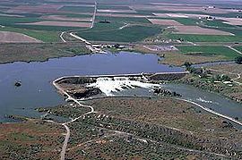
American Falls Dam
The American Falls Dam is a concrete gravity-type dam located near the town of American Falls, Idaho, on river mile 714.7 of the Snake River. The dam and reservoir are a part of the Minidoka Project on the Snake River Plain and are used primarily for flood control, irrigation, and recreation...
. A 40 miles (64.4 km)-long lake, known as American Falls Lake, formed behind the barrier. The lake was stable and survived for nearly 30,000 years. About 14,500 years ago, pluvial
Pluvial
In geology and climatology, a pluvial was an extended period of abundant rainfall lasting many thousands of years. Pluvial is also applied to the sediments of these periods . The term is especially applied to such periods during the Pleistocene Epoch...
Lake Bonneville
Lake Bonneville
Lake Bonneville was a prehistoric pluvial lake that covered much of North America's Great Basin region. Most of the territory it covered was in present-day Utah, though parts of the lake extended into present-day Idaho and Nevada. Formed about 32,000 years ago, it existed until about 14,500 years...
in the Great Salt Lake
Great Salt Lake
The Great Salt Lake, located in the northern part of the U.S. state of Utah, is the largest salt water lake in the western hemisphere, the fourth-largest terminal lake in the world. In an average year the lake covers an area of around , but the lake's size fluctuates substantially due to its...
area, formed in the last glacial period, spilled catastrophically down the Portneuf River
Portneuf River (Idaho)
The Portneuf River is a tributary of the Snake River in southeastern Idaho in the United States. It drains a ranching and farming valley in the mountains southeast of the Snake River Plain...
into the Snake in an event known as the Bonneville Flood
Bonneville Flood
The Bonneville Flood or Lake Bonneville Flood was a catastrophic flooding event in the previous ice age, which involved massive amounts of water inundating parts of southern Idaho and eastern Washington along the course of the Snake River. Unlike the Missoula Floods, which also occurred during the...
. This was one of the first in a series of catastrophic flooding events in the Northwest known as the Ice Age Floods. The deluge caused American Falls Lake to breach its natural lava dam, which was rapidly eroded away with only the 50 feet (15.2 m)-high American Falls left in the end. The flood waters of Lake Bonneville, approximately twenty times the flow of the Columbia River or 5300000 cuft/s, swept down the Snake River leaving debris and sediment deposits across southern Idaho. For miles on either side of the Snake flood waters stripped away soils and scoured the underlying basalt bedrock, in the process creating Shoshone Falls, Twin Falls, Crane Falls, and Swan Falls, while cutting and deepening gorges and canyons along the way. The Bonneville flood waters continued through Hells Canyon. The flood widened Hells Canyon but did not deepen it.
As the Bonneville Floods rushed down the Snake River, the Missoula Floods
Missoula Floods
The Missoula Floods refer to the cataclysmic floods that swept periodically across eastern Washington and down the Columbia River Gorge at the end of the last ice age. The glacial flood events have been researched since the 1920s...
occurred in the same period, but farther north. The Missoula Floods, which took place over 40 times in the time span from 15,000 to 13,000 years ago, were caused by Glacial Lake Missoula
Glacial Lake Missoula
Glacial Lake Missoula was a prehistoric proglacial lake in western Montana that existed periodically at the end of the last ice age between 15,000 and 13,000 years ago...
on the Clark Fork
Clark Fork (river)
The Clark Fork is a river in the U.S. states of Montana and Idaho, approximately long. The largest river by volume in Montana, it drains an extensive region of the Rocky Mountains in western Montana and northern Idaho in the watershed of the Columbia River, flowing northwest through a long...
repeatedly being impounded by ice dams then breaking through, with the lake's water rushing over much of eastern Washington in massive surges far larger than the Lake Bonneville Flood. These floods pooled behind the Cascade Range
Cascade Range
The Cascade Range is a major mountain range of western North America, extending from southern British Columbia through Washington and Oregon to Northern California. It includes both non-volcanic mountains, such as the North Cascades, and the notable volcanoes known as the High Cascades...
into enormous lakes and spilled over the northern drainage divide of the Snake River watershed, carving deep canyons through the Palouse Hills. The Palouse River
Palouse River
The Palouse River is a tributary of the Snake River located in the U.S. states of Washington and Idaho. It flows for southwestwards, primarily through the Palouse region of southeastern Washington...
canyon was the largest of the many gorges cut through the Palouse Hills, and could not have become as large as it now is if it were not for the Missoula Floods. The Lake Bonneville floods and the Missoula Floods helped widen and deepen the Columbia River Gorge
Columbia River Gorge
The Columbia River Gorge is a canyon of the Columbia River in the Pacific Northwest of the United States. Up to deep, the canyon stretches for over as the river winds westward through the Cascade Range forming the boundary between the State of Washington to the north and Oregon to the south...
, a giant water gap
Water gap
A water gap is an opening or notch which flowing water has carved through a mountain range. Water gaps often offer a practical route for road and rail transport to cross mountain ridges.- Geology :...
which allows water from the Columbia and Snake rivers to take a direct route through the Cascade Range
Cascade Range
The Cascade Range is a major mountain range of western North America, extending from southern British Columbia through Washington and Oregon to Northern California. It includes both non-volcanic mountains, such as the North Cascades, and the notable volcanoes known as the High Cascades...
to the Pacific.
The massive amounts of sediment deposited by the Lake Bonneville Floods in the Snake River Plain also had a lasting effect on most of the middle Snake River. The high hydraulic conductivity
Hydraulic conductivity
Hydraulic conductivity, symbolically represented as K, is a property of vascular plants, soil or rock, that describes the ease with which water can move through pore spaces or fractures. It depends on the intrinsic permeability of the material and on the degree of saturation...
of the mostly-basalt
Basalt
Basalt is a common extrusive volcanic rock. It is usually grey to black and fine-grained due to rapid cooling of lava at the surface of a planet. It may be porphyritic containing larger crystals in a fine matrix, or vesicular, or frothy scoria. Unweathered basalt is black or grey...
rocks in the plain led to the formation of the Snake River Aquifer
Snake River Aquifer
The Snake River Aquifer is a large reservoir of groundwater underlying the Snake River Plain in the southern part of the U.S. state of Idaho. Most of the water in the aquifer comes from rain and melting snow that flows onto the plain from the Snake River, Big Lost River, Bruneau River, and other...
, one of the most productive aquifers in North America. Many rivers and streams flowing from the north side of the plain sink into the aquifer instead of flowing into the Snake River, a group of watersheds called the lost streams of Idaho. The aquifer filled to hold nearly 100000000 acre.ft of water, underlying about 10000 square miles (25,899.9 km²) in a plume 1300 feet (396.2 m) thick. In places, water exits from rivers at rates of nearly 600 cuft/s. Much of the water lost by the Snake River as it transects the plain issues back into the river at its western end, by way of many artesian
Artesian aquifer
An artesian aquifer is a confined aquifer containing groundwater under positive pressure. This causes the water level in a well to rise to a point where hydrostatic equilibrium has been reached. This type of well is called an artesian well...
spring
Spring (hydrosphere)
A spring—also known as a rising or resurgence—is a component of the hydrosphere. Specifically, it is any natural situation where water flows to the surface of the earth from underground...
s.
Watershed
By length the Snake River is the thirteenth largest river in the United States. Its watershed is the tenth largest among North American rivers, and covers almost 108000 square miles (279,718.7 km²) in portions of six U.S. states: WyomingWyoming
Wyoming is a state in the mountain region of the Western United States. The western two thirds of the state is covered mostly with the mountain ranges and rangelands in the foothills of the Eastern Rocky Mountains, while the eastern third of the state is high elevation prairie known as the High...
, Idaho
Idaho
Idaho is a state in the Rocky Mountain area of the United States. The state's largest city and capital is Boise. Residents are called "Idahoans". Idaho was admitted to the Union on July 3, 1890, as the 43rd state....
, Nevada
Nevada
Nevada is a state in the western, mountain west, and southwestern regions of the United States. With an area of and a population of about 2.7 million, it is the 7th-largest and 35th-most populous state. Over two-thirds of Nevada's people live in the Las Vegas metropolitan area, which contains its...
, Utah
Utah
Utah is a state in the Western United States. It was the 45th state to join the Union, on January 4, 1896. Approximately 80% of Utah's 2,763,885 people live along the Wasatch Front, centering on Salt Lake City. This leaves vast expanses of the state nearly uninhabited, making the population the...
, Oregon
Oregon
Oregon is a state in the Pacific Northwest region of the United States. It is located on the Pacific coast, with Washington to the north, California to the south, Nevada on the southeast and Idaho to the east. The Columbia and Snake rivers delineate much of Oregon's northern and eastern...
, and Washington, with the largest portion in Idaho. Most of the Snake River watershed lies between the Rocky Mountains
Rocky Mountains
The Rocky Mountains are a major mountain range in western North America. The Rocky Mountains stretch more than from the northernmost part of British Columbia, in western Canada, to New Mexico, in the southwestern United States...
on the east and the Columbia Plateau
Columbia Plateau
The Columbia Plateau is a geologic and geographic region that lies across parts of the U.S. states of Washington, Oregon, and Idaho. It is a wide flood basalt plateau between the Cascade Range and the Rocky Mountains, cut through by the Columbia River...
on the northwest. The largest tributary of the Columbia River, the Snake River watershed makes up about 41 % of the entire Columbia River Basin. Its average discharge at the mouth constitutes 31 % of the Columbia's flow at that point. Above the confluence, the Snake is slightly longer than the Columbia—1078 miles (1,734.9 km) compared to 928 miles (1,493.5 km)—and its drainage basin is slightly larger—4% bigger than the upstream Columbia River watershed.
The mostly semi-arid
Semi-arid
A semi-arid climate or steppe climate describes climatic regions that receive precipitation below potential evapotranspiration, but not extremely...
, even desert
Desert
A desert is a landscape or region that receives an extremely low amount of precipitation, less than enough to support growth of most plants. Most deserts have an average annual precipitation of less than...
climate of the Snake River watershed on average, as a whole, typically receives less than 12 inches (304.8 mm) of precipitation
Precipitation (meteorology)
In meteorology, precipitation In meteorology, precipitation In meteorology, precipitation (also known as one of the classes of hydrometeors, which are atmospheric water phenomena is any product of the condensation of atmospheric water vapor that falls under gravity. The main forms of precipitation...
per year. However, precipitation in the Snake River watershed varies widely. At Twin Falls, in the center of the Snake River Plain, the climate is nearly desert, with an annual rainfall of just 9.24 inches (234.7 mm), although the average snowfall is 13.1 inches (332.7 mm). This desert climate occupies the majority of the basin of the Snake River, so although it is longer than the Columbia River above the Tri-Cities, its discharge is on average significantly less. However, in the high Rockies of Wyoming, in the upper Jackson Hole area, the average precipitation is over 30 inches (762 mm), and snowfall averages 252 inches (6,400.8 mm). Most of the Snake River basin consists of wide, arid plains and rolling hills, bordered by high mountains. In the upper parts of the watershed, however, the river flows through an area with a distinct alpine climate
Alpine climate
Alpine climate is the average weather for a region above the tree line. This climate is also referred to as mountain climate or highland climate....
. There are also stretches where the river and its tributaries have incised themselves into tight gorges. The Snake River watershed includes parts of Yellowstone National Park
Yellowstone National Park
Yellowstone National Park, established by the U.S. Congress and signed into law by President Ulysses S. Grant on March 1, 1872, is a national park located primarily in the U.S. state of Wyoming, although it also extends into Montana and Idaho...
, Grand Teton National Park
Grand Teton National Park
Grand Teton National Park is a United States National Park located in northwestern Wyoming, U.S. The Park consists of approximately and includes the major peaks of the long Teton Range as well as most of the northern sections of the valley known as Jackson Hole. Only south of Yellowstone...
, Hells Canyon National Recreation Area
Hells Canyon National Recreation Area
Hells Canyon National Recreation Area is a United States National Recreation Area located on the borders of the U.S. states of Oregon and Idaho. The recreation area was established by U.S...
, and many other national and state parks.
Much of the area along the river, within a few miles of its banks, is irrigated farmland, especially in its middle and lower course. Irrigation dams include American Falls Dam
American Falls Dam
The American Falls Dam is a concrete gravity-type dam located near the town of American Falls, Idaho, on river mile 714.7 of the Snake River. The dam and reservoir are a part of the Minidoka Project on the Snake River Plain and are used primarily for flood control, irrigation, and recreation...
, Minidoka Dam
Minidoka Dam
The Minidoka Dam is an earthfill dam on the Snake River in south central Idaho. The dam, originally completed in 1906, is east of Rupert on county highway 400; it is 86 feet high and nearly a mile in length, with a wide overflow spillway section. The dam and power plant were listed on the...
, and C.J. Strike Dam. Aside from water from the river, water is also pulled from the Snake River Aquifer for irrigation. Major cities along the river include Jackson
Jackson, Wyoming
Jackson is a town located in the Jackson Hole valley of Teton County, Wyoming, United States. The population was 8,647 at the 2000 census. It is the county seat of Teton County....
in Wyoming, Twin Falls
Twin Falls, Idaho
Twin Falls is the county seat and largest city of Twin Falls County, Idaho, United States. The population was 44,125 at the 2010 censusTwin Falls is the largest city of Idaho's Magic Valley region...
, Idaho Falls, Boise
Boise, Idaho
Boise is the capital and most populous city of the U.S. state of Idaho, as well as the county seat of Ada County. Located on the Boise River, it anchors the Boise City-Nampa metropolitan area and is the largest city between Salt Lake City, Utah and Portland, Oregon.As of the 2010 Census Bureau,...
, and Lewiston
Lewiston, Idaho
Lewiston is a city in and also the county seat of Nez Perce County in the Pacific Northwest state of Idaho. It is the second-largest city in the northern Idaho region, behind Coeur d'Alene and ninth-largest in the state. Lewiston is the principal city of the Lewiston, ID - Clarkston, WA...
in Idaho, and the Tri-Cities in Washington (Kennewick
Kennewick, Washington
Kennewick is a city in Benton County in the southeastern part of the U.S. state of Washington, near the Hanford nuclear site. It is the most populous of the three cities collectively referred to as the Tri-Cities...
, Pasco
Pasco, Washington
Pasco is a city in and the county seat of Franklin County, Washington, United States.Pasco is one of three cities that make up the Tri-Cities region of the state of Washington...
and Richland
Richland, Washington
Richland is a city in Benton County in the southeastern part of the U.S. state of Washington, at the confluence of the Yakima and the Columbia Rivers. As of the 2010 census, the city population was 48,058. April 1, 2011 estimates from the Washington State Office of Financial Management put the...
). There are fifteen dams in total along the Snake River, which aside from irrigation, also produce electricity, maintain a navigation channel along part of the river's route, and provide flood control. However, fish passage is limited to the stretch below Hells Canyon.
The Snake River watershed is bounded by several other major North American watersheds, which drain both to the Atlantic or the Pacific, or into endorheic
Endorheic
An endorheic basin is a closed drainage basin that retains water and allows no outflow to other bodies of water such as rivers or oceans...
basins. On the southwest side a divide separates the Snake watershed from Oregon's Harney Basin
Harney Basin
The Harney Basin is a structural basin in southeastern Oregon in the United States at the northwestern corner of the Great Basin. One of the least populated areas of the contiguous United States, it is located largely in northern Harney County, bounded on the north and east by the Columbia Plateau,...
, which is endorheic. On the south, the Snake watershed borders that of the Humboldt River
Humboldt River
The Humboldt River runs through northern Nevada in the western United States. At approximately long it is the second longest river in the Great Basin, after the Bear River. It has no outlet to the ocean, but instead empties into the Humboldt Sink...
in Nevada
Nevada
Nevada is a state in the western, mountain west, and southwestern regions of the United States. With an area of and a population of about 2.7 million, it is the 7th-largest and 35th-most populous state. Over two-thirds of Nevada's people live in the Las Vegas metropolitan area, which contains its...
, and the watershed of the Great Salt Lake
Great Salt Lake
The Great Salt Lake, located in the northern part of the U.S. state of Utah, is the largest salt water lake in the western hemisphere, the fourth-largest terminal lake in the world. In an average year the lake covers an area of around , but the lake's size fluctuates substantially due to its...
(the Bear
Bear River (Utah)
The Bear River is a river, approximately long, in southwestern Wyoming, southeastern Idaho, and northern Utah, in the United States. The largest tributary of the Great Salt Lake, it drains a mountainous area and farming valleys northeast of the lake and southeast of the Snake River Plain...
, Jordan
Jordan River (Utah)
The Jordan River in the U.S. state of Utah is a river about long. Regulated by pumps at its headwaters at Utah Lake, it flows northward through the Salt Lake Valley and empties into the Great Salt Lake. Four of Utah's five largest cities—Salt Lake City, West Valley City, West Jordan and...
and Weber
Weber River
The Weber River is a c. long river of northern Utah, USA. It begins in the northwest of the Uinta Mountains and empties into the Great Salt Lake. The Weber River was named for American fur trapper John Henry Weber.-Weber River:...
rivers) on the south.
The Snake River also shares a boundary with the Green River
Green River (Utah)
The Green River, located in the western United States, is the chief tributary of the Colorado River. The watershed of the river, known as the Green River Basin, covers parts of Wyoming, Utah, and Colorado. The Green River is long, beginning in the Wind River Mountains of Wyoming and flowing...
to the southeast; the Green River drains parts of Wyoming and Utah and is the largest tributary of the Colorado River
Colorado River
The Colorado River , is a river in the Southwestern United States and northwestern Mexico, approximately long, draining a part of the arid regions on the western slope of the Rocky Mountains. The watershed of the Colorado River covers in parts of seven U.S. states and two Mexican states...
. On the western extremity for a short stretch the Continental Divide separates the Snake watershed from the Bighorn River
Bighorn River
The Bighorn River is a tributary of the Yellowstone, approximately long, in the western United States in the states of Wyoming and Montana. The river was named in 1805 by fur trader François Larocque for the Bighorn Sheep he saw along its banks as he explored the Yellowstone River.The upper...
, a tributary of the Yellowstone River
Yellowstone River
The Yellowstone River is a tributary of the Missouri River, approximately long, in the western United States. Considered the principal tributary of the upper Missouri, the river and its tributaries drain a wide area stretching from the Rocky Mountains in the vicinity of the Yellowstone National...
, which the Snake begins near. On the north the Snake River watershed is bounded by the Red Rock River
Jefferson River
The Jefferson River is a tributary of the Missouri River, approximately long, in the U.S. state of Montana. The Jefferson River and the Madison River form the official beginning of the Missouri at Missouri Headwaters State Park near Three Forks...
, a tributary of the Beaverhead River
Beaverhead River
The Beaverhead River is an approximately -long tributary of the Jefferson River in southwest Montana . It drains an area of roughly . The river's original headwaters, formed by the confluence of the Red Rock River and Horse Prairie Creek, are now flooded under Clark Canyon Reservoir, which also...
, which flows into the Jefferson River
Jefferson River
The Jefferson River is a tributary of the Missouri River, approximately long, in the U.S. state of Montana. The Jefferson River and the Madison River form the official beginning of the Missouri at Missouri Headwaters State Park near Three Forks...
and into the Missouri River
Missouri River
The Missouri River flows through the central United States, and is a tributary of the Mississippi River. It is the longest river in North America and drains the third largest area, though only the thirteenth largest by discharge. The Missouri's watershed encompasses most of the American Great...
, part of the Gulf of Mexico
Gulf of Mexico
The Gulf of Mexico is a partially landlocked ocean basin largely surrounded by the North American continent and the island of Cuba. It is bounded on the northeast, north and northwest by the Gulf Coast of the United States, on the southwest and south by Mexico, and on the southeast by Cuba. In...
drainage basin.
The rest of the Snake River watershed borders on several other major Columbia River tributaries - mostly the Spokane River
Spokane River
The Spokane River is a tributary of the Columbia River, approximately long, in northern Idaho and eastern Washington in the United States. It drains a low mountainous area east of the Columbia, passing through the city of Spokane, Washington.-Description:...
to the north, but also Clark Fork
Clark Fork (river)
The Clark Fork is a river in the U.S. states of Montana and Idaho, approximately long. The largest river by volume in Montana, it drains an extensive region of the Rocky Mountains in western Montana and northern Idaho in the watershed of the Columbia River, flowing northwest through a long...
in Montana
Montana
Montana is a state in the Western United States. The western third of Montana contains numerous mountain ranges. Smaller, "island ranges" are found in the central third of the state, for a total of 77 named ranges of the Rocky Mountains. This geographical fact is reflected in the state's name,...
to the northeast and the John Day River
John Day River
The John Day River is a tributary of the Columbia River, approximately long, in northeastern Oregon in the United States. Undammed along its entire length, the river is the third longest free-flowing river in the conterminous United States. There is extensive use of its waters for irrigation. Its...
to the west. Of these, the Clark Fork (via the Pend Oreille River
Pend Oreille River
The Pend Oreille River is a tributary of the Columbia River, approximately long, in northern Idaho and northeastern Washington in the United States, as well as southeastern British Columbia in Canada. In its passage through British Columbia its name is spelled Pend-d'Oreille River...
) and the Spokane join the Columbia above the Snake, while the John Day joins downstream of the Snake, in the Columbia River Gorge
Columbia River Gorge
The Columbia River Gorge is a canyon of the Columbia River in the Pacific Northwest of the United States. Up to deep, the canyon stretches for over as the river winds westward through the Cascade Range forming the boundary between the State of Washington to the north and Oregon to the south...
. It is of note that the northeastern divide of the Snake River watershed forms the Idaho-Montana boundary, so the Snake River watershed does not extend into Montana.
Mountain ranges in the Snake watershed include the Teton Range
Teton Range
The Teton Range is a mountain range of the Rocky Mountains in North America. A north-south range, it is on the Wyoming side of the state's border with Idaho, just south of Yellowstone National Park. Most of the range is in Grand Teton National Park....
, Bitterroot Range
Bitterroot Range
The Bitterroot Range runs along the border of Montana and Idaho in the northwestern United States. The range spans an area of 62,736 square kilometers and is named after the bitterroot , a small pink flower that is the state flower of Montana.- History :In 1805, the Corps of Discovery,...
, Clearwater Mountains
Clearwater Mountains
The Clearwater Mountains are part of the Rocky Mountains, located in the panhandle of Idaho in the Western United States. The mountains lie between the Salmon River and the Bitterroot Range and encompass an area of .- North Clearwater Mountains :...
, Seven Devils Mountains
Seven Devils Mountains
The Seven Devils are notable peaks in west central Idaho in the Hells Canyon Wilderness. They are above the east bank of the Snake River, which forms the Idaho-Oregon border. The mountains are part of the Rocky Mountains, and the tallest peaks are 7900 vertical feet above the adjacent Snake...
, and the extreme northwestern end of the Wind River Range
Wind River Range
The Wind River Range , is a mountain range of the Rocky Mountains in western Wyoming in the United States. The range runs roughly NW-SE for approximately 100 miles . The Continental Divide follows the crest of the range and includes Gannett Peak, which at 13,804 feet , is the highest peak...
. Grand Teton
Grand Teton
Grand Teton is the highest mountain in Wyoming's Grand Teton National Park, and a classic destination in American mountaineering.- Geography :...
is the highest point in the Snake River watershed, reaching 13775 feet (4,198.6 m) in elevation. The elevation of the Snake River is 358 feet (109.1 m) when it joins the Columbia River.
Pollution
Agricultural runoff from farmFarm
A farm is an area of land, or, for aquaculture, lake, river or sea, including various structures, devoted primarily to the practice of producing and managing food , fibres and, increasingly, fuel. It is the basic production facility in food production. Farms may be owned and operated by a single...
s and ranch
Ranch
A ranch is an area of landscape, including various structures, given primarily to the practice of ranching, the practice of raising grazing livestock such as cattle or sheep for meat or wool. The word most often applies to livestock-raising operations in the western United States and Canada, though...
es in the Snake River Plain and many other areas has severely hurt the ecology of the river throughout the 20th century. After the first irrigation dams on the river begun operation in the first decade of the 20th century, much of the arable land
Arable land
In geography and agriculture, arable land is land that can be used for growing crops. It includes all land under temporary crops , temporary meadows for mowing or pasture, land under market and kitchen gardens and land temporarily fallow...
in a strip a few miles wide along the Snake River was cultivated
Tillage
Tillage is the agricultural preparation of the soil by mechanical agitation of various types, such as digging, stirring, and overturning. Examples of human-powered tilling methods using hand tools include shovelling, picking, mattock work, hoeing, and raking...
or turned to pasture
Pasture
Pasture is land used for grazing. Pasture lands in the narrow sense are enclosed tracts of farmland, grazed by domesticated livestock, such as horses, cattle, sheep or swine. The vegetation of tended pasture, forage, consists mainly of grasses, with an interspersion of legumes and other forbs...
, and agricultural return flows began to pollute the Snake. Runoff from several feedlot
Feedlot
A feedlot or feedyard is a type of animal feeding operation which is used in factory farming for finishing livestock, notably beef cattle, but also swine, horses, sheep, turkeys, chickens or ducks, prior to slaughter. Large beef feedlots are called Concentrated Animal Feeding Operations . They...
s was dumped into the river until laws made the practice illegal. Fertilizer
Fertilizer
Fertilizer is any organic or inorganic material of natural or synthetic origin that is added to a soil to supply one or more plant nutrients essential to the growth of plants. A recent assessment found that about 40 to 60% of crop yields are attributable to commercial fertilizer use...
, manure
Manure
Manure is organic matter used as organic fertilizer in agriculture. Manures contribute to the fertility of the soil by adding organic matter and nutrients, such as nitrogen, that are trapped by bacteria in the soil...
and other chemicals and pollutants washed into the river greatly increase the nutrient load, especially of phosphorus
Phosphorus
Phosphorus is the chemical element that has the symbol P and atomic number 15. A multivalent nonmetal of the nitrogen group, phosphorus as a mineral is almost always present in its maximally oxidized state, as inorganic phosphate rocks...
, fecal coliforms and nitrogen
Nitrogen
Nitrogen is a chemical element that has the symbol N, atomic number of 7 and atomic mass 14.00674 u. Elemental nitrogen is a colorless, odorless, tasteless, and mostly inert diatomic gas at standard conditions, constituting 78.08% by volume of Earth's atmosphere...
. During low water, algae blooms occur throughout the calm stretches of the river, depleting its oxygen supply.
Spring (hydrosphere)
A spring—also known as a rising or resurgence—is a component of the hydrosphere. Specifically, it is any natural situation where water flows to the surface of the earth from underground...
. Throughout much of the Snake River Plain and Hells Canyon, excessive sediment is also a recurring problem. In December 2007, the U.S. Environmental Protection Agency (EPA) issued a permit requiring owners of fish farms along the Snake River to reduce their phosphorus discharge by 40 percent. Pollutant levels in Hells Canyon upstream of the Salmon River
Salmon River (Idaho)
The Salmon River is located in Idaho in the northwestern United States. The Salmon is also known as The River of No Return. It flows for through central Idaho, draining and dropping more than between its headwaters, near Galena Summit above the Sawtooth Valley in the Sawtooth National...
confluence, including that of water temperature, dissolved nutrients, and sediment, are required to meet certain levels.
Discharge
The Snake River's average flow is 54830 cuft/s. The United States Geological SurveyUnited States Geological Survey
The United States Geological Survey is a scientific agency of the United States government. The scientists of the USGS study the landscape of the United States, its natural resources, and the natural hazards that threaten it. The organization has four major science disciplines, concerning biology,...
recorded the river's discharge from a period of 1963–2000 at a stream gauge
Stream gauge
A stream gauge, stream gage or gauging station is a location used by hydrologists or environmental scientists to monitor and test terrestrial bodies of water. Hydrometric measurements of water surface elevation and/or volumetric discharge are generally taken and observations of biota may also be...
below Ice Harbor Dam. In that period, the largest average annual flow recorded was 84190 cuft/s in 1997, and the lowest was 27100 cuft/s in 1992. The lowest recorded daily mean flow was 2700 cuft/s on February 4, 1979. On August 27, 1965 there was temporarily no flow as a result of testing at Ice Harbor Dam. The highest recorded flow was 312000 cuft/s on June 19, 1974. The highest flow ever recorded on the Snake River was at a different USGS stream gauge near Clarkston, which operated from 1915 to 1972. This gauge recorded a maximum flow of 369000 cuft/s—more than the Columbia's average discharge—on May 29, 1948. An even larger peak discharge, estimated at 409000 cuft/s, occurred during the flood of June, 1894.
The river's flow is also measured at several other points in its course. Above Jackson Lake, Wyoming, the discharge is about 885 cuft/s from a drainage area of 486 square miles (1,258.7 km²). At Minidoka, Idaho
Minidoka, Idaho
Minidoka is a city in Minidoka County, Idaho, United States. The population was 129 at the 2000 census. It is part of the Burley, Idaho Micropolitan Statistical Area....
, about halfway through the Snake River Plain, the river's discharge rises to 7841 cuft/s. However, at Buhl, Idaho
Buhl, Idaho
Buhl is a city located on the old Oregon Trail in the western half of Twin Falls County, Idaho, United States. The population was 4,037 at the 2000 census. It is part of the Twin Falls, Idaho Micropolitan Statistical Area....
, only about 50 miles (80.5 km) downstream, the river's flow decreases to 4908 cuft/s because of agricultural diversions and seepage. But at the border of Idaho and Oregon, near Weiser
Weiser, Idaho
Weiser is a city in the rural western part of the U.S. state of Idaho and the county seat of Washington County. With its mild climate, the city supports farm, orchard, and livestock endeavors in the vicinity. The city sits at the confluence of the Weiser River with the great Snake River, which...
at the beginning of Hells Canyon, the Snake's flow rises to 17780 cuft/s after receiving several major tributaries such as the Payette
Payette River
The Payette River is an river in southwestern Idaho and is a major tributary of the Snake River.Its headwaters originate in the Sawtooth and Salmon River Mountains at elevations over...
, Owyhee
Owyhee River
The Owyhee River is a tributary of the Snake River located in northern Nevada, southwestern Idaho and southeastern Oregon in the United States. It is long. The river's drainage basin is in area, one of the largest subbasins of the Columbia Basin...
and Malheur
Malheur River
The Malheur River is a tributary of the Snake River in eastern Oregon in the United States. It drains a high desert area, between the Harney Basin and the Blue Mountains and the Snake....
. The discharge further increases to 19530 cuft/s at Hells Canyon Dam
Hells Canyon Dam
Hells Canyon Dam is a concrete gravity dam on the Snake River in Hells Canyon on the Idaho-Oregon border. The dam impounds the Snake River in Hells Canyon Reservoir; its spillway elevation is above sea level....
on the border of Idaho and Oregon. At Anatone, Washington
Anatone, Washington
Anatone is an unincorporated community in Asotin County, Washington. Because it is not tracked by the U.S. Census, a Census population estimate is not available. However the citizens of Anatone perform a population census themselves and update the sign every summer...
, downstream of the confluences with the Salmon
Salmon River (Idaho)
The Salmon River is located in Idaho in the northwestern United States. The Salmon is also known as The River of No Return. It flows for through central Idaho, draining and dropping more than between its headwaters, near Galena Summit above the Sawtooth Valley in the Sawtooth National...
, Clearwater
Clearwater River (Idaho)
The Clearwater River is a river in north central Idaho, which flows westward from the Bitterroot Mountains along the Idaho-Montana border, and joins the Snake River at Lewiston. In October 1805, the Lewis and Clark Expedition descended the Clearwater River in dugout canoes, putting in at "Canoe...
and others of the Snake's largest tributaries, the mean discharge is 34560 cuft/s.
Name
Canadian explorer David ThompsonDavid Thompson (explorer)
David Thompson was an English-Canadian fur trader, surveyor, and map-maker, known to some native peoples as "Koo-Koo-Sint" or "the Stargazer"...
first recorded the Native American name of the Snake River as Shawpatin when he arrived at its mouth by boat in 1800. When the Lewis and Clark Expedition
Lewis and Clark Expedition
The Lewis and Clark Expedition, or ″Corps of Discovery Expedition" was the first transcontinental expedition to the Pacific Coast by the United States. Commissioned by President Thomas Jefferson and led by two Virginia-born veterans of Indian wars in the Ohio Valley, Meriwether Lewis and William...
crossed westwards into the Snake River watershed in 1805, they first gave it the name Lewis River, Lewis Fork or Lewis's Fork, as Meriwether Lewis
Meriwether Lewis
Meriwether Lewis was an American explorer, soldier, and public administrator, best known for his role as the leader of the Lewis and Clark Expedition also known as the Corps of Discovery, with William Clark...
was the first of their group to sight the river.
They also made note of the "Snake Indians" who lived along the river, who were actually the Shoshone
Shoshone
The Shoshone or Shoshoni are a Native American tribe in the United States with three large divisions: the Northern, the Western and the Eastern....
tribe, and learned that the Native Americans called the river Ki-moo-e-nim or Yam-pah-pa (for a herb that grew prolifically along its banks).
Later American explorers, some of whom were originally part of the Lewis and Clark expedition, journeyed into the Snake River watershed and records show a variety of names have been associated with the river. The explorer Wilson Price Hunt of the Astor Expedition
Astor Expedition
The Astor Expedition of 1810-1812 was the next overland expedition from St. Louis, Missouri to the mouth of the Columbia River after the Corps of Discovery, led by Lewis and Clark.-History:...
named the river as Mad River. Others gave the river names including Shoshone River (after the tribe) and Saptin River. Eventually, the name Snake River was derived from an S-shaped gesture the Shoshone tribe made with their hands to represent swimming salmon
Salmon
Salmon is the common name for several species of fish in the family Salmonidae. Several other fish in the same family are called trout; the difference is often said to be that salmon migrate and trout are resident, but this distinction does not strictly hold true...
. Explorers misinterpreted it to represent a snake
Snake
Snakes are elongate, legless, carnivorous reptiles of the suborder Serpentes that can be distinguished from legless lizards by their lack of eyelids and external ears. Like all squamates, snakes are ectothermic, amniote vertebrates covered in overlapping scales...
, giving the river its present-day name.
Early inhabitants
Clovis culture
The Clovis culture is a prehistoric Paleo-Indian culture that first appears 11,500 RCYBP , at the end of the last glacial period, characterized by the manufacture of "Clovis points" and distinctive bone and ivory tools...
, Folsom
Folsom tradition
The Folsom Complex is a name given by archaeologists to a specific Paleo-Indian archaeological culture that occupied much of central North America...
, and Plano cultures
Plano cultures
The Plano cultures is a name given by archaeologists to a group of disparate hunter-gatherer communities that occupied the Great Plains area of North America during the Paleo-Indian period in the United States and the Paleo-Indian or Archaic period in Canada....
dating back over 10,000 years ago.
Early fur traders and explorers noted regional trading centers, and archaeological evidence has shown some to be of considerable antiquity. One such trading center in the Weiser
Weiser, Idaho
Weiser is a city in the rural western part of the U.S. state of Idaho and the county seat of Washington County. With its mild climate, the city supports farm, orchard, and livestock endeavors in the vicinity. The city sits at the confluence of the Weiser River with the great Snake River, which...
area existed as early as 4,500 years ago. The Fremont culture
Fremont culture
The Fremont culture or Fremont people is a pre-Columbian archaeological culture which received its name from the Fremont River in the U.S. state of Utah where the first Fremont sites were discovered. The Fremont River itself is named for John Charles Frémont, an American explorer. It inhabited...
may have contributed to the historic Shoshone
Shoshone
The Shoshone or Shoshoni are a Native American tribe in the United States with three large divisions: the Northern, the Western and the Eastern....
s, but it is not well understood. Another poorly understood early cultural component is called the Midvale Complex. The introduction of the horse to the Snake River Plain around 1700 helped in establishing the Shoshone and Northern Paiute
Paiute
Paiute refers to three closely related groups of Native Americans — the Northern Paiute of California, Idaho, Nevada and Oregon; the Owens Valley Paiute of California and Nevada; and the Southern Paiute of Arizona, southeastern California and Nevada, and Utah.-Origin of name:The origin of...
cultures.
On the Snake River in southeastern Washington there are several ancient sites. One of the oldest and most well-known is called the Marmes Rockshelter, which was used from over 11,000 years ago to relatively recent times. The Marmes Rockshelter
Marmes Rockshelter
The Marmes Rockshelter is an archaeological site first excavated in 1962, near the confluence of the Snake and Palouse Rivers, in Franklin County, southeastern Washington. This rockshelter is remarkable in the level of preservation of organic materials, the depth of stratified deposits, and the...
was flooded in 1968 by Lake Herbert G. West
Lake Herbert G. West
Lake Herbert G. West is a reservoir formed by the Lower Monumental Dam. It extends up the Snake River for 28 miles to the tailwater of Little Goose Dam...
, the Lower Monumental Dam's reservoir.
Eventually, two large Native American groups controlled most of the Snake River: the Nez Perce, whose territory stretched from the southeastern Columbia Plateau into northern Oregon and western Idaho, and the Shoshone, who occupied the Snake River Plain both above and below Shoshone Falls
Shoshone Falls
Shoshone Falls is a waterfall on the Snake River located approximately five miles east of Twin Falls, Idaho. Sometimes called the "Niagara of the West," Shoshone Falls is 212 feet high—45 feet higher than Niagara Falls—and flows over a rim 1,000 feet wide.A park overlooking the waterfall is...
. Lifestyles along the Snake River varied widely. Below Shoshone Falls, the economy centered around salmon
Salmon
Salmon is the common name for several species of fish in the family Salmonidae. Several other fish in the same family are called trout; the difference is often said to be that salmon migrate and trout are resident, but this distinction does not strictly hold true...
, who often came up the river in enormous numbers. Salmon were the mainstay of the Nez Perce and most of the other tribes below Shoshone Falls. Above the falls, life was significantly different. The Snake River Plain
Snake River Plain
The Snake River Plain is a geologic feature located primarily within the state of Idaho in the United States of America. It stretches about westward from northwest of the state of Wyoming to the Idaho-Oregon border. The plain is a wide flat bow-shaped depression, and covers about a quarter of Idaho...
forms one of the only relatively easy paths across the main Rocky Mountains for many hundreds of miles, allowing Native Americans both east and west of the mountains to interact. As a result, the Shoshone centered around a trading economy.
According to legend, the Nez Perce tribe was first founded in the valley of the Clearwater River, one of the Snake River's lowermost major tributaries. At its height, there were at least 27 Nez Perce settlements along the Clearwater River and 11 more on the Snake between the mouth of the Clearwater and Imnaha River
Imnaha River
The Imnaha River is a tributary of the Snake River in the U.S. state of Oregon. Flowing generally east near the headwaters and then north through Wallowa County, the entire river is designated Wild and Scenic...
s. There were also villages on the Salmon River
Salmon River (Idaho)
The Salmon River is located in Idaho in the northwestern United States. The Salmon is also known as The River of No Return. It flows for through central Idaho, draining and dropping more than between its headwaters, near Galena Summit above the Sawtooth Valley in the Sawtooth National...
, Grande Ronde River
Grande Ronde River
The Grande Ronde River is a tributary of the Snake River, long, in northeastern Oregon and southeastern Washington in the United States. It drains an area southeast of the Blue Mountains and northwest of the Wallowa Mountains, on the Columbia Plateau...
, Tucannon River
Tucannon River
The Tucannon River is a river in southeastern Washington state that flows from headwaters in the Blue Mountains to a confluence with the Snake River upstream from Lyons Ferry Park and the mouth of the Palouse River. The Tucannon itself drains and is long...
, and the lower Hells Canyon area. The Snake River's annual salmon run, which was estimated at that time to exceed four million in good years, supported the Nez Perce, who lived in permanent, well-defined villages, unlike the nomadic southeastern tribes along the Snake River. The Nez Perce also were involved in trade with the Flathead tribe to the north and other middle Columbia River tribes. However, they were enemies to the Shoshone and the other upstream Snake River tribes.
The Shoshone or Shoshoni were characterized by nomadic groups that took their culture from the earlier Bitterroot culture and Great Basin
Great Basin
The Great Basin is the largest area of contiguous endorheic watersheds in North America and is noted for its arid conditions and Basin and Range topography that varies from the North American low point at Badwater Basin to the highest point of the contiguous United States, less than away at the...
tribes that migrated north via the Owyhee River
Owyhee River
The Owyhee River is a tributary of the Snake River located in northern Nevada, southwestern Idaho and southeastern Oregon in the United States. It is long. The river's drainage basin is in area, one of the largest subbasins of the Columbia Basin...
. They were the most powerful tribe in the Rocky Mountains area, and were known to many Great Plains
Great Plains
The Great Plains are a broad expanse of flat land, much of it covered in prairie, steppe and grassland, which lies west of the Mississippi River and east of the Rocky Mountains in the United States and Canada. This area covers parts of the U.S...
tribes as the "Snakes". In the 18th century, Shoshone territory extended beyond the Snake River Plain, extending over the Continental Divide into the upper Missouri River
Missouri River
The Missouri River flows through the central United States, and is a tributary of the Mississippi River. It is the longest river in North America and drains the third largest area, though only the thirteenth largest by discharge. The Missouri's watershed encompasses most of the American Great...
watershed and even further north into Canada
Canada
Canada is a North American country consisting of ten provinces and three territories. Located in the northern part of the continent, it extends from the Atlantic Ocean in the east to the Pacific Ocean in the west, and northward into the Arctic Ocean...
. A smallpox
Smallpox
Smallpox was an infectious disease unique to humans, caused by either of two virus variants, Variola major and Variola minor. The disease is also known by the Latin names Variola or Variola vera, which is a derivative of the Latin varius, meaning "spotted", or varus, meaning "pimple"...
epidemic brought by European explorers and fur trappers was responsible for wiping out much of the Shoshone east of the Rocky Mountains, but the Shoshone continued to occupy the Snake River Plain. Eventually, the Shoshone culture merged with that of the Paiute
Paiute
Paiute refers to three closely related groups of Native Americans — the Northern Paiute of California, Idaho, Nevada and Oregon; the Owens Valley Paiute of California and Nevada; and the Southern Paiute of Arizona, southeastern California and Nevada, and Utah.-Origin of name:The origin of...
and Bannock
Bannock (tribe)
The Bannock tribe of the Northern Paiute are an indigenous people of the Great Basin. Their traditional lands include southeastern Oregon, southeastern Idaho, western Wyoming, and southwestern Montana...
tribes, which came from the Great Basin and the Hells Canyon area, respectively. The Bannock brought with them the skill of buffalo
Bison
Members of the genus Bison are large, even-toed ungulates within the subfamily Bovinae. Two extant and four extinct species are recognized...
hunting and horse
Horse
The horse is one of two extant subspecies of Equus ferus, or the wild horse. It is a single-hooved mammal belonging to the taxonomic family Equidae. The horse has evolved over the past 45 to 55 million years from a small multi-toed creature into the large, single-toed animal of today...
s they had acquired from Europeans, changing the Shoshone way of life significantly.
Exploration and settling
The Lewis and Clark ExpeditionLewis and Clark Expedition
The Lewis and Clark Expedition, or ″Corps of Discovery Expedition" was the first transcontinental expedition to the Pacific Coast by the United States. Commissioned by President Thomas Jefferson and led by two Virginia-born veterans of Indian wars in the Ohio Valley, Meriwether Lewis and William...
(1804–06) was the first American group to cross the Rocky Mountains
Rocky Mountains
The Rocky Mountains are a major mountain range in western North America. The Rocky Mountains stretch more than from the northernmost part of British Columbia, in western Canada, to New Mexico, in the southwestern United States...
and sail down the Snake and Columbia rivers to the Pacific Ocean. Meriwether Lewis
Meriwether Lewis
Meriwether Lewis was an American explorer, soldier, and public administrator, best known for his role as the leader of the Lewis and Clark Expedition also known as the Corps of Discovery, with William Clark...
supposedly became the first American to sight the drainage basin of the Snake River after he crossed the mountains a few days ahead of his party on August 12, 1805, and sighted the Salmon River
Salmon River (Idaho)
The Salmon River is located in Idaho in the northwestern United States. The Salmon is also known as The River of No Return. It flows for through central Idaho, draining and dropping more than between its headwaters, near Galena Summit above the Sawtooth Valley in the Sawtooth National...
valley (a major Snake tributary) from Lemhi Pass
Lemhi Pass
Lemhi Pass is a high mountain pass in the Beaverhead Mountains, part of the Bitterroot Range in the Rocky Mountains The pass lies on the Montana-Idaho border on the continental divide, at an elevation of 7373 feet above sea level.-History:...
, a few miles from the present-day site of Salmon, Idaho
Salmon, Idaho
Salmon is a city in Lemhi County, Idaho, United States. The population was 3,122 at the 2000 census. The city is the county seat of Lemhi County...
. The party later traveled north, descended the Lemhi River
Lemhi River
The Lemhi River is a river in Idaho in the United States. It is a tributary of the Salmon River, which in turn is tributary to the Snake River and Columbia River.-Course:...
to the Salmon and attempted to descend it to the Snake, but found it impassable because of its violent rapids. The expedition named the Snake River the Lewis River, Lewis's River, or Lewis Fork, in his honor. as a result traveled northwards to the Lochsa River
Lochsa River
The Lochsa River is located in the northwestern United States, in the mountains of north central Idaho. It is one of two primary tributaries of the Middle Fork of the Clearwater River in the Clearwater National Forest. Lochsa is a Nez Perce word meaning rough water.The Lochsa was included by the...
, which they traveled via the Clearwater River
Clearwater River (Idaho)
The Clearwater River is a river in north central Idaho, which flows westward from the Bitterroot Mountains along the Idaho-Montana border, and joins the Snake River at Lewiston. In October 1805, the Lewis and Clark Expedition descended the Clearwater River in dugout canoes, putting in at "Canoe...
into the lower Snake, and into the Columbia. They also referred to the Shoshone Indians as the "Snake Indians", which became the present-day name of the river. The name "Lewis Fork", however, did not last.
Later American explorers traveled throughout the Snake River area and up its major tributaries beginning in 1806, just after Lewis and Clark had returned. The first was John Ordway
John Ordway
Sergeant John Ordway , the youngest of ten siblings, was an important part of the Lewis and Clark Expedition across the United States. John Ordway was one of the sergeants from the United States Army who stepped forward as a volunteer for the expedition...
in 1806, who also explored the lower Salmon River. John Colter
John Colter
John Colter was a member of the Lewis and Clark Expedition . Though party to one of the more famous expeditions in history, Colter is best remembered for explorations he made during the winter of 1807–1808, when Colter became the first known person of European descent to enter the region now known...
in 1808 was the first to sight the upper headwaters of the Snake River, including the Jackson Hole
Jackson Hole
Jackson Hole, originally called Jackson's Hole, is a valley located in the U.S. state of Wyoming, near the western border with Idaho. The name "hole" derives from language used by early trappers or mountain men, who primarily entered the valley from the north and east and had to descend along...
area.
In 1810, Andrew Henry
Andrew Henry (fur trader)
Major Andrew Henry was an American fur trader who, with William H. Ashley started the Rocky Mountain Fur Company in 1822...
, along with a party of fur trappers, discovered the Henrys Fork of the Snake River, which is now named after him. Donald Mackenzie sailed the lower Snake River in 1811, and later explorers included Wilson Price Hunt of the Astor Expedition
Astor Expedition
The Astor Expedition of 1810-1812 was the next overland expedition from St. Louis, Missouri to the mouth of the Columbia River after the Corps of Discovery, led by Lewis and Clark.-History:...
(who gave the river the name "Mad River"), Ramsay Crooks
Ramsay Crooks
Ramsay Crooks immigrated to Canada from Scotland in 1803 and he worked in a trading post on the Great Lakes. He helped W. Price Hunt to organize and lead an overland trip to Astoria in the Oregon Country for John Jacob Astor in 1809 through 1813, as a partner in the Pacific Fur Company...
, Francisco Payelle, John Grey, Thyery Goddin, and many others after the 1830s. Many of these later explorers were original members of the Lewis and Clark Expedition who had returned to map and explore the area in greater detail. Even later, American fur trappers scouted the area for beaver streams, but Canadian trappers from the British
United Kingdom
The United Kingdom of Great Britain and Northern IrelandIn the United Kingdom and Dependencies, other languages have been officially recognised as legitimate autochthonous languages under the European Charter for Regional or Minority Languages...
Hudson's Bay Company
Hudson's Bay Company
The Hudson's Bay Company , abbreviated HBC, or "The Bay" is the oldest commercial corporation in North America and one of the oldest in the world. A fur trading business for much of its existence, today Hudson's Bay Company owns and operates retail stores throughout Canada...
were by now a major competitor.
The Hudson's Bay Company first sent fur trappers into the Snake River watershed in 1819. The party of three traveled into the headwaters of the Owyhee River
Owyhee River
The Owyhee River is a tributary of the Snake River located in northern Nevada, southwestern Idaho and southeastern Oregon in the United States. It is long. The river's drainage basin is in area, one of the largest subbasins of the Columbia Basin...
, a major southern tributary of the Snake, but disappeared. Meanwhile, as American fur trappers kept coming to the region, the Hudson's Bay Company ordered the Canadian trappers to kill as many beavers as they could, eventually nearly eradicating the species from the Snake River watershed, under the "rationale [that] if there are no beavers, there will be no reason for the Yanks
Yankee
The term Yankee has several interrelated and often pejorative meanings, usually referring to people originating in the northeastern United States, or still more narrowly New England, where application of the term is largely restricted to descendants of the English settlers of the region.The...
(Americans) to come." Their goal was to eventually gain rights over the Oregon Territory
Oregon Territory
The Territory of Oregon was an organized incorporated territory of the United States that existed from August 14, 1848, until February 14, 1859, when the southwestern portion of the territory was admitted to the Union as the State of Oregon. Originally claimed by several countries , the region was...
, a region covering Washington, Oregon, Idaho, and parts of Montana and Wyoming (most of the present-day region called the Pacific Northwest). However, the area was eventually annexed into the United States, and England lost its claim on Canada.
By the middle 19th century, the Oregon Trail
Oregon Trail
The Oregon Trail is a historic east-west wagon route that connected the Missouri River to valleys in Oregon and locations in between.After 1840 steam-powered riverboats and steamboats traversing up and down the Ohio, Mississippi and Missouri rivers sped settlement and development in the flat...
had been established, generally following much of the Snake River. One crossing the trail made over the Snake River was near the present-day site of Ontario, Oregon
Ontario, Oregon
Ontario is the largest city in Malheur County, Oregon, United States. It lies along the Snake River at the Idaho border. The population was 10,985 at the 2000 census, with an estimated population of 11,245 in 2006...
. Several years later, a ferry was established at the site, replacing the old system where pioneers had to ford the wide, powerful and deep Snake. Another place where pioneers crossed the Snake was further upstream, at a place called "Three Island Crossing", near the mouth of the Boise River
Boise River
The Boise River is a tributary of the Snake River in the northwestern United States. It drains a rugged portion of the Sawtooth Range in southwestern Idaho northeast of Boise, as well as part of the western Snake River Plain...
. This area has a group of three islands (hence the name) that splits the Snake into four channels each about 200 feet (61 m) wide. Some emigrants chose to ford the Snake and proceed down the west side and recross the river near Fort Boise into Hells Canyon, continue down the drier east side into the gorge, or float the Snake and Columbia to the Willamette River
Willamette River
The Willamette River is a major tributary of the Columbia River, accounting for 12 to 15 percent of the Columbia's flow. The Willamette's main stem is long, lying entirely in northwestern Oregon in the United States...
, the destination of the Oregon Trail. The reason for the Three Island Crossing was the better availability of grass and water access. Numerous ferries have provided crossings of the upper Snake from the Brownlee Ferry at the head of Hell's Canyon to Menor's Ferry
Menor's Ferry
Menor's Ferry was a river ferry that crossed the Snake River near the present-day Moose, Wyoming. The site was homesteaded by Bill Menor in 1892-94, choosing a location where the river flowed in a single channel, rather than the braided stream that characterizes its course in most of Jackson Hole. ...
, which operates today at Moose, Wyoming. Sophistication varied from reed boat
Reed boat
Reed boats and rafts, along with dugout canoes and other rafts, are among the oldest known types of boats. Often used as traditional fishing boats, they are still used in a few places around the world, though they have generally been replaced with planked boats. Reed boats can be distinguished from...
s pulled by Indians on horse back at Snake Fort, Fort Boise
Fort Boise
Fort Boise refers to two different locations in southwestern Idaho. The first was a Hudson's Bay Company trading post near the Snake River on the Oregon border, dating from the era when Idaho was part of the fur company's Columbia District. After several rebuilds, it was ultimately abandoned in...
, as described by Narcissa Whitman
Narcissa Whitman
Narcissa Prentiss Whitman was an American missionary in the Oregon Country of what would become the state of Washington. Along with Eliza Hart Spalding , she was the first European-American woman to cross the Rocky Mountains in 1836 on her way to found the Protestant Whitman Mission with husband Dr...
in 1836 to an electric operated ferry, the Swan Falls Ferry, at Swan Falls Dam
Swan Falls Dam
Swan Falls Dam is a concrete gravity type hydroelectric dam on the Snake River, in the U.S. state of Idaho. It is located near Murphy, Idaho.The dam was built in 1901 to generate electricity. It is the oldest hydroelectric dam on the Snake River. In the 1990s the original power plant was replaced...
of the early 20th century.
Steamboats
Unlike the Columbia River, it was far more difficult for steamboatSteamboat
A steamboat or steamship, sometimes called a steamer, is a ship in which the primary method of propulsion is steam power, typically driving propellers or paddlewheels...
s to navigate on the Snake. The Columbia River drops 2690 feet (819.9 m) from source to mouth, while the Snake drops over 8500 feet (2,590.8 m) in elevation over a length more than 200 miles (321.9 km) shorter. Still, from the 1860s to the 1940s, steamboats traveled on the Snake River from its mouth at the Columbia River to near the mouth of the Imnaha River
Imnaha River
The Imnaha River is a tributary of the Snake River in the U.S. state of Oregon. Flowing generally east near the headwaters and then north through Wallowa County, the entire river is designated Wild and Scenic...
in lower Hells Canyon. However, most of the steamboats only sailed from the river's mouth to Lewiston
Lewiston, Idaho
Lewiston is a city in and also the county seat of Nez Perce County in the Pacific Northwest state of Idaho. It is the second-largest city in the northern Idaho region, behind Coeur d'Alene and ninth-largest in the state. Lewiston is the principal city of the Lewiston, ID - Clarkston, WA...
, located at the confluence of the Snake and Clearwater rivers. This stretch of the river is the easiest to navigate for watercraft since it has the least elevation change, although it still contained over 60 sets of rapids.
Passenger and freight service downstream of Lewiston lasted throughout the late 19th century and persisted until the introduction of railroads in the Palouse Hills grain
GRAIN
GRAIN is a small international non-profit organisation that works to support small farmers and social movements in their struggles for community-controlled and biodiversity-based food systems. Our support takes the form of independent research and analysis, networking at local, regional and...
-growing region and ultimately, the construction of dams on the lower Snake to facilitate barge
Barge
A barge is a flat-bottomed boat, built mainly for river and canal transport of heavy goods. Some barges are not self-propelled and need to be towed by tugboats or pushed by towboats...
traffic, which caused the demise of both the steamboats and the railroad. Lewiston, 140 miles (225.3 km) from the confluence of the Snake and Columbia and 465 miles (748.3 km) from the mouth of the Columbia on the Pacific Ocean, became connected with Portland
Portland, Oregon
Portland is a city located in the Pacific Northwest, near the confluence of the Willamette and Columbia rivers in the U.S. state of Oregon. As of the 2010 Census, it had a population of 583,776, making it the 29th most populous city in the United States...
and other Pacific ports via steamboat service from the mouth of the Snake through the Columbia River Gorge
Columbia River Gorge
The Columbia River Gorge is a canyon of the Columbia River in the Pacific Northwest of the United States. Up to deep, the canyon stretches for over as the river winds westward through the Cascade Range forming the boundary between the State of Washington to the north and Oregon to the south...
. A commonly traveled route was from Wallula, Washington
Wallula, Washington
Wallula is a census-designated place in Walla Walla County, Washington, United States. The population was 179 at the 2010 census.-History:Lewis and Clark reached the area April 27, 1806, on their return journey from the Pacific...
, 120 miles (193.1 km) downstream of the Snake River's mouth, upstream to Lewiston. The Oregon Steam Navigation Company
Oregon Steam Navigation Company
The Oregon Steam Navigation Company was an American company incorporated in 1860 in Washington with partners J. S. Ruckle, Henry Olmstead, and J. O. Van Bergen...
launched the Shoshone
Shoshone (Snake River sternwheeler)
The Shoshone was the first steamboat built on the Snake River, Idaho, above Hells Canyon and the first of only two steamboats to be brought down through Hells Canyon to the lower Snake River. This was considered one of the most astounding feats of steamboat navigation ever accomplished.-Design and...
at Fort Boise
Fort Boise
Fort Boise refers to two different locations in southwestern Idaho. The first was a Hudson's Bay Company trading post near the Snake River on the Oregon border, dating from the era when Idaho was part of the fur company's Columbia District. After several rebuilds, it was ultimately abandoned in...
in 1866 which provided passenger and freight service on the upper Snake for the Boise and Owyhee mines.
By the 1870s, the OSN Company, owned by the Northern Pacific Railroad, was operating seven steamboats for transporting wheat
Wheat
Wheat is a cereal grain, originally from the Levant region of the Near East, but now cultivated worldwide. In 2007 world production of wheat was 607 million tons, making it the third most-produced cereal after maize and rice...
and grain from the producive Palouse region along the Snake and Columbia to lower Columbia River ports. These boats were the Harvest Queen, John Gates, Spokane, Annie Faxon
Annie Faxon (sternwheeler)
Annie Faxon was a steamboat that was built by the Oregon Steam Navigation Company. She is chiefly remembered now for the catastrophic boiler explosion in 1893 that destroyed her and killed eight people on board.-Design and Construction:...
, Mountain Queen, R.R. Thompson, and Wide West, all of which were built on the Columbia River. However, there were more resources along the Snake River than wheat and grain. In the 1890s, a huge copper
Copper
Copper is a chemical element with the symbol Cu and atomic number 29. It is a ductile metal with very high thermal and electrical conductivity. Pure copper is soft and malleable; an exposed surface has a reddish-orange tarnish...
deposit was discovered at Eureka Bar in Hells Canyon. Several ships were built specifically to transport ore from there to Lewiston: these included Imnaha, Mountain Gem, and Norma. A disaster in 1893 involved Annie Faxon sinking on the Snake below Lewiston because of a boiler explosion.
Dams
Many factors have influenced the construction of dams along the Snake River. A total of fifteen dams have been constructed along the Snake River for a multitude of different purposes, from its headwaters in the Rocky Mountains to its mouth on Lake UmatillaLake Umatilla
Lake Umatilla is a long reservoir on the Columbia River in the United States, between the U.S. states of Washington and Oregon. It was created in 1971 with the construction of John Day Dam, and stretches upstream to the McNary Dam. It lies in parts of Sherman, Gilliam, Morrow, and Umatilla...
. Dams on the Snake can be grouped into three major categories. From its headwaters to the beginning of Hells Canyon, many small dams block the Snake to provide irrigation
Irrigation
Irrigation may be defined as the science of artificial application of water to the land or soil. It is used to assist in the growing of agricultural crops, maintenance of landscapes, and revegetation of disturbed soils in dry areas and during periods of inadequate rainfall...
water. Between here and Hells Canyon, the first dam on the Snake, Swan Falls Dam
Swan Falls Dam
Swan Falls Dam is a concrete gravity type hydroelectric dam on the Snake River, in the U.S. state of Idaho. It is located near Murphy, Idaho.The dam was built in 1901 to generate electricity. It is the oldest hydroelectric dam on the Snake River. In the 1990s the original power plant was replaced...
, was built in 1901. In Hells Canyon, a cascade of dams produce hydroelectricity
Hydroelectricity
Hydroelectricity is the term referring to electricity generated by hydropower; the production of electrical power through the use of the gravitational force of falling or flowing water. It is the most widely used form of renewable energy...
from the river's lofty decrease in elevation over a comparatively small distance. Finally, a third cascade of dams, from Hells Canyon to the mouth, facilitates navigation. Many different government and private agencies have worked to build dams on the Snake River, which now serve an important purpose for people living in the Snake's drainage basin and trade of agricultural products to Pacific seaports.
The Minidoka Irrigation Project of the U.S. Bureau of Reclamation, created with the passage of the Reclamation Act of 1902, involved the diversion of Snake River water into the Snake River Plain upstream of Shoshone Falls
Shoshone Falls
Shoshone Falls is a waterfall on the Snake River located approximately five miles east of Twin Falls, Idaho. Sometimes called the "Niagara of the West," Shoshone Falls is 212 feet high—45 feet higher than Niagara Falls—and flows over a rim 1,000 feet wide.A park overlooking the waterfall is...
in order to irrigate approximately 1100000 acres (4,451.5 km²) in the Snake River Plain and store 4100000 acre.ft of water in Snake River reservoirs.
The first studies for irrigation in the Plain were conducted by the U.S. Geological Survey in the late 19th century, and the project was authorized on April 23, 1904. The first dam constructed for the project was Minidoka Dam
Minidoka Dam
The Minidoka Dam is an earthfill dam on the Snake River in south central Idaho. The dam, originally completed in 1906, is east of Rupert on county highway 400; it is 86 feet high and nearly a mile in length, with a wide overflow spillway section. The dam and power plant were listed on the...
in 1904; its power plant began operating in 1909, producing 7 mW of electricity. This capacity was revised to 20 MW in 1993. However, Minidoka Dam was not the only dam constructed for the project. As far upstream as Jackson Lake
Jackson Lake
Jackson Lake is a lake located in north western Wyoming in Grand Teton National Park. The lake is natural, except for the top 33 feet , which is due to the construction of Jackson Lake Dam, built in 1911. This top level of the lake is utilized by farmers in Idaho for irrigation purposes...
in Wyoming, the Jackson Lake Dam
Jackson Lake Dam
Jackson Lake Dam is a concrete and earth-fill dam at the outlet of Jackson Lake in northwestern Wyoming, USA. The lake and dam are situated within Grand Teton National Park in Teton County. The Snake River emerges from the dam and flows about through Wyoming, Idaho, Oregon, and Washington to its...
was built in 1907 to raise the lake level for providing additional water storage for dry years. American Falls Dam
American Falls Dam
The American Falls Dam is a concrete gravity-type dam located near the town of American Falls, Idaho, on river mile 714.7 of the Snake River. The dam and reservoir are a part of the Minidoka Project on the Snake River Plain and are used primarily for flood control, irrigation, and recreation...
, upstream of Minidoka, was completed in 1927 and replaced in 1978. As the dams were constructed above Shoshone Falls, the historical upriver limit of salmon and also a total barrier to boats and ships, no provisions were made for fish passage or navigation. Several other irrigation dams were also built - including Twin Falls Dam and Palisades Dam
Palisades Dam
thumb|300px|Palisades Reservoir in winterPalisades Dam is an earth-fill dam on the Snake River in Bonneville County in the U.S. state of Idaho. The dam was completed in 1957 and provides irrigation water, flood control, and recreation; it features a four-turbine hydroelectric power plant. The dam...
.
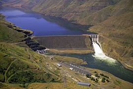
Idaho Power Company
Idaho Power Company is a regulated electrical power utility. Its business involves the purchase, sale, generation, transmission and distribution of electricity in eastern Oregon and southern Idaho. It is a subsidiary of IDACORP, Inc...
starting in the 1940s, and was the second of the three major water projects on the river. The three dams of the project, Brownlee Dam
Brownlee Dam
Brownlee Dam is a hydroelectric earth fill embankment dam on the Snake River on the Idaho-Oregon border, in Hells Canyon . It impounds the Snake River in the long Brownlee Reservoir...
, Oxbow Dam
Oxbow Dam
Oxbow Dam is a hydroelectric run-of-the-river rockfill dam on the Snake River on the Idaho-Oregon border, in Hells Canyon . It is part of the Hells Canyon Project that also includes Hells Canyon Dam and Brownlee Dam, built and operated by Idaho Power Company.The dam's powerhouse contains four...
and Hells Canyon Dam
Hells Canyon Dam
Hells Canyon Dam is a concrete gravity dam on the Snake River in Hells Canyon on the Idaho-Oregon border. The dam impounds the Snake River in Hells Canyon Reservoir; its spillway elevation is above sea level....
, are located in upper Hells Canyon
Hells Canyon
Hells Canyon is a wide canyon located along the border of eastern Oregon and western Idaho in the United States. It is North America's deepest river gorge at and part of the Hells Canyon National Recreation Area....
. All three dams are primarily for power generation and flood control, and do not have fish passage or navigation locks. Brownlee Dam, the most upriver dam, was constructed in 1959, and generates 728 MW of power. Oxbow Dam, the second dam in the project, was built in 1961 and generates 220 MW. The dam was named for a 3 miles (4.8 km)-wide bend in the Snake River, shaped like an oxbow, although not an oxbow lake
Oxbow lake
An oxbow lake is a U-shaped body of water formed when a wide meander from the main stem of a river is cut off to create a lake. This landform is called an oxbow lake for the distinctive curved shape, named after part of a yoke for oxen. In Australia, an oxbow lake is called a billabong, derived...
. Hells Canyon Dam was the last and most downriver of the three, was constructed in 1967 and generates 450 MW.
Downriver of the Hells Canyon is the Lower Snake River Project, authorized by the Rivers and Harbors Act of 1945, which was created by the U.S. Army Corps of Engineers to create a navigable channel on the Snake River from its mouth to the beginning of Hells Canyon. These dams are, in downstream order: Lower Granite Lock and Dam
Lower Granite Lock and Dam
Lower Granite Lock and Dam is a concrete gravity run-of-the-river dam on the Snake River, and bridges Whitman County and Garfield County, in the U.S. state of Washington. The dam is located 22 miles south of the town of Colfax, and 35 miles north of Pomeroy.Lower Granite Dam is part of the...
, Little Goose Lock and Dam
Little Goose Lock and Dam
Little Goose Lock and Dam is a hydroelectric, concrete, run-of-the-river dam in Columbia and Whitman counties in the state of Washington, on the Snake River. The dam is located northeast of the town of Starbuck, and north of Dayton....
, Lower Monumental Lock and Dam
Lower Monumental Lock and Dam
Lower Monumental Lock and Dam is a hydroelectric, concrete, run-of-the-river dam on the Snake River, and bridges Franklin County and Walla Walla County, in the state of Washington. The dam is located six miles south of the town of Kahlotus, and 43 miles north of the town of Walla...
, and Ice Harbor Lock and Dam
Ice Harbor Lock and Dam
Ice Harbor Lock and Dam is a hydroelectric, concrete gravity run-of-the-river dam on the Snake River in Walla Walla and Franklin counties in the U.S. state of Washington. The dam is located 8 miles northeast of the town of Burbank and 12 miles east of Pasco, river mile 9.2...
. Dredging work was also done throughout the length of the navigation channel to facilitate ship passage. These dams form a cascade of reservoirs with no stretches of free-flowing river in between. Immediately below Ice Harbor Dam is Lake Wallula
Lake Wallula
Lake Wallula is a reservoir on the Columbia River in the United States, between the U.S. states of Washington and Oregon. It was created in 1954 with the construction of McNary Dam. It reaches from McNary Dam near the city of Umatilla, Oregon, to the Tri-Cities of Washington.-See also:* Wallula...
, formed by the construction of the McNary Dam
McNary Dam
McNary Dam is a 1.4-mile long concrete gravity run-of-the-river dam which spans the Columbia River. It joins Umatilla County, Oregon with Benton County, Washington, 292 miles upriver from the mouth of the Columbia at Astoria, Oregon. It is operated by the U.S. Army Corps of Engineers' McNary...
on the Columbia River. (McNary Dam is not part of the Lower Snake River Project.) Above Lower Granite Dam, the river channel from Lewiston to Johnson Bar, just below Hells Canyon, is also maintained for ships. These dams have been proposed for removal, and if they were to be removed, it would be the largest dam removal project ever undertaken in the United States. The removal has been proposed on the grounds that it would restore salmon runs to the lower Snake River and the Clearwater River
Clearwater River (Idaho)
The Clearwater River is a river in north central Idaho, which flows westward from the Bitterroot Mountains along the Idaho-Montana border, and joins the Snake River at Lewiston. In October 1805, the Lewis and Clark Expedition descended the Clearwater River in dugout canoes, putting in at "Canoe...
and other smaller tributaries, although there would be a loss of hydroelectric power generated by the dams.
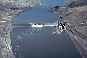
Navigation
In the 1960s and 1970s the U.S. Army Corps of Engineers built four dams and locks on the lower Snake River to facilitate shipping. The lower Columbia River has likewise been dammed for navigation. Thus a deep shipping channelChannel (geography)
In physical geography, a channel is the physical confine of a river, slough or ocean strait consisting of a bed and banks.A channel is also the natural or human-made deeper course through a reef, sand bar, bay, or any shallow body of water...
through locks and slackwater reservoirs for heavy barge
Barge
A barge is a flat-bottomed boat, built mainly for river and canal transport of heavy goods. Some barges are not self-propelled and need to be towed by tugboats or pushed by towboats...
s exists from the Pacific Ocean to Lewiston, Idaho. Most barge traffic originating on the Snake River goes to deep-water ports on the lower Columbia River, such as Portland
Portland, Oregon
Portland is a city located in the Pacific Northwest, near the confluence of the Willamette and Columbia rivers in the U.S. state of Oregon. As of the 2010 Census, it had a population of 583,776, making it the 29th most populous city in the United States...
. Grain
GRAIN
GRAIN is a small international non-profit organisation that works to support small farmers and social movements in their struggles for community-controlled and biodiversity-based food systems. Our support takes the form of independent research and analysis, networking at local, regional and...
, mostly wheat
Wheat
Wheat is a cereal grain, originally from the Levant region of the Near East, but now cultivated worldwide. In 2007 world production of wheat was 607 million tons, making it the third most-produced cereal after maize and rice...
, is the main product shipped from the Snake, and nearly all of it is exported internationally from the lower Columbia River ports.
The shipping channel is authorized to be at least 14 feet (4.3 m) deep and 250 feet (76.2 m) wide. Where river depths were less than 14 feet (4 m), the shipping channel has been dredged in most places. Dredging and redredging work is ongoing and actual depths vary over time. With a channel about 5 feet (1.5 m) deeper than the Mississippi River
Mississippi River
The Mississippi River is the largest river system in North America. Flowing entirely in the United States, this river rises in western Minnesota and meanders slowly southwards for to the Mississippi River Delta at the Gulf of Mexico. With its many tributaries, the Mississippi's watershed drains...
system, the Columbia and Snake rivers can float barges twice as heavy. Agricultural products from Idaho and eastern Washington are among the main goods transported by barge on the Snake and Columbia rivers. Grain, mainly wheat, accounts for more than 85% of the cargo barged on the lower Snake River. In 1998, over 123000000 bushels (4,334,405,610 l) of grain were barged on the Snake. Before the completion of the lower Snake dams, grain from the region was transported by truck or rail to Columbia River ports around the Tri-Cities. Other products barged on the lower Snake River include peas, lentils, forest products, and petroleum.
Biology
The World Wide Fund for NatureWorld Wide Fund for Nature
The World Wide Fund for Nature is an international non-governmental organization working on issues regarding the conservation, research and restoration of the environment, formerly named the World Wildlife Fund, which remains its official name in Canada and the United States...
(WWF) divides the Snake River's watershed into two freshwater ecoregions: the "Columbia Unglaciated" ecoregion and the "Upper Snake" ecoregion. Shoshone Falls marks the boundary between the two. The WWF placed the ecoregion boundary about 50 kilometres (31.1 mi) downriver from Shoshone Falls in order to include the Big Wood River
Big Wood River
The Big Wood River is a river in central Idaho. It is a tributary of the Malad River, which in turn is tributary to the Snake River and Columbia River.-Course:...
(the main tributary of the Malad River
Malad River
The Malad River is a tributary of the Snake River in Idaho in the United States. It is formed by the confluence of the Big Wood River and the Little Wood River near Gooding. From there the river flows south and west for to join the Snake River near Hagerman....
) in the Upper Snake ecoregion, because the Wood River is biologically distinct from the rest of the downriver Snake. Shoshone Falls has presented a total barrier to the upstream movement of fish for 30,000 to 60,000 years. As a result only 35% of the fish fauna above the falls, and 40% of the Wood River's fish fauna, are shared with the lower Snake River.
The Upper Snake freshwater ecoregion includes most of southeastern Idaho and extends into small portions of Wyoming, Utah, and Nevada, including major freshwater habitats such as Jackson Lake
Jackson Lake
Jackson Lake is a lake located in north western Wyoming in Grand Teton National Park. The lake is natural, except for the top 33 feet , which is due to the construction of Jackson Lake Dam, built in 1911. This top level of the lake is utilized by farmers in Idaho for irrigation purposes...
. Compared to the lower Snake River and the rest of the Columbia River's watershed, the Upper Snake ecoregion has a high level of endemism, especially among freshwater mollusc
Freshwater mollusc
Freshwater molluscs are those members of the Phylum Mollusca which live in freshwater habitats, both lotic such as rivers, streams, canals, springs, and underground cave streams and lentic such as lakes, ponds , and ditches.This article is about freshwater Mollusca in general; for information on...
s such as snails
Gastropoda
The Gastropoda or gastropods, more commonly known as snails and slugs, are a large taxonomic class within the phylum Mollusca. The class Gastropoda includes snails and slugs of all kinds and all sizes from microscopic to quite large...
and clams
Bivalvia
Bivalvia is a taxonomic class of marine and freshwater molluscs. This class includes clams, oysters, mussels, scallops, and many other families of molluscs that have two hinged shells...
. There are at least twenty-one snail and clam species of special concern, including fifteen which appear to exist only in single clusters. There are fourteen fish species found in the Upper Snake region that do not occur elsewhere in the Columbia's watershed, but which do occur in Bonneville freshwater ecoregion of western Utah, part of the Great Basin
Great Basin
The Great Basin is the largest area of contiguous endorheic watersheds in North America and is noted for its arid conditions and Basin and Range topography that varies from the North American low point at Badwater Basin to the highest point of the contiguous United States, less than away at the...
and related to the prehistoric Lake Bonneville
Lake Bonneville
Lake Bonneville was a prehistoric pluvial lake that covered much of North America's Great Basin region. Most of the territory it covered was in present-day Utah, though parts of the lake extended into present-day Idaho and Nevada. Formed about 32,000 years ago, it existed until about 14,500 years...
. The Wood River sculpin
Wood River sculpin
The Wood River sculpin is a species of fish in the Cottidae family. It is endemic to the United States.-Source:* Gimenez Dixon, M. 1996. . Downloaded on 4 August 2007....
(Cottus leiopomus) is endemic to the Wood River. The Shoshone sculpin
Shoshone sculpin
The Shoshone sculpin is a species of fish in the Cottidae family. It is endemic to the United States.-Source:* Gimenez Dixon, M. 1996. . Downloaded on 4 August 2007....
(Cottus greenei) is endemic to the small portion of the Snake River between Shoshone Falls and the Wood River.
The Snake River below Shoshone Falls is home to thirty-five native fish species, of which twelve are also found in the Columbia River and four of which are endemic to the Snake: the relict sand roller (Percopsis transmontana) of the Percopsidae
Percopsidae
Percopsidae is a family of fish in the order Percopsiformes. Its living members are two North American fresh water species of the genus Percopsis, trout-perch Percopsis omiscomaycus and sand roller Percopsis transmontana .They are small fish with weak fin spines, and an adipose fin similar to...
family, the shorthead sculpin
Sculpin
A Sculpin is a fish that belongs to the order Scorpaeniformes, suborder Cottoidei and superfamily Cottoidea, that contains 11 families, 149 genera, and 756 species...
(Cottus confusus), the maginated sculpin (Cottus marginatus), and the Oregon chub
Oregonichthys
Oregonichthys is a genus of ray-finned fish in the Cyprinidae family. Collectively known as Oregon chubs, that term can also refer to O. crameri in particular.- Species :* Oregonichthys crameri...
(Oregonichthys crameri). The Oregon chub is also found in the Umpqua River
Umpqua River
The Umpqua River on the Pacific coast of Oregon in the United States is approximately long. One of the principal rivers of the Oregon Coast and known for bass and shad, the river drains an expansive network of valleys in the mountains west of the Cascade Range and south of the Willamette Valley,...
and nearby basins. The lower Snake River also supports seven species of salmon (Oncorhynchus
Oncorhynchus
Oncorhynchus is a genus of fish in the family Salmonidae; it contains the Pacific salmons and Pacific trouts. The name of the genus is derived from the Greek onkos and rynchos , in reference to the hooked jaws of males in the mating season .-Range:Salmon and trout with ranges generally in waters...
). There are also high, often localized levels of mollusc endemism, especially in Hells Canyon and the basins of the Clearwater River, Salmon River, and middle Snake River. The mollusc richness extends into the lower Columbia River and tributaries such as the Deschutes River.
Animals
Aside from aquatic species, much of the Snake River watershed supports larger animals including numerous species of mammals, birds, amphibians, and reptiles. Especially in the headwaters and the other mountainous areas strewn throughout the watershed, the gray wolfGray Wolf
The gray wolf , also known as the wolf, is the largest extant wild member of the Canidae family...
, grizzly bear
Grizzly Bear
The grizzly bear , also known as the silvertip bear, the grizzly, or the North American brown bear, is a subspecies of brown bear that generally lives in the uplands of western North America...
, wolverine
Wolverine
The wolverine, pronounced , Gulo gulo , also referred to as glutton, carcajou, skunk bear, or quickhatch, is the largest land-dwelling species of the family Mustelidae . It is a stocky and muscular carnivore, more closely resembling a small bear than other mustelids...
, mountain lion and Canada lynx
Canada Lynx
The Canada lynx or Canadian lynx is a North American mammal of the cat family, Felidae. It is a close relative of the Eurasian Lynx . Some authorities regard both as conspecific. However, in some characteristics the Canada lynx is more like the bobcat than the Eurasian Lynx...
are common. It has been determined that there are 97 species of mammals in the upper part of the Snake River, upstream from the Henrys Fork confluence. Pronghorn
Pronghorn
The pronghorn is a species of artiodactyl mammal endemic to interior western and central North America. Though not an antelope, it is often known colloquially in North America as the prong buck, pronghorn antelope, or simply antelope, as it closely resembles the true antelopes of the Old World and...
and bighorn sheep
Bighorn Sheep
The bighorn sheep is a species of sheep in North America named for its large horns. These horns can weigh up to , while the sheep themselves weigh up to . Recent genetic testing indicates that there are three distinct subspecies of Ovis canadensis, one of which is endangered: Ovis canadensis sierrae...
are common in the area drained by the lost streams of Idaho, several rivers and large creeks that flow south from the Rocky Mountains and disappear into the Snake River Aquifer. About 274 bird species, some endangered or threatened, use the Snake River watershed, including bald eagle
Bald Eagle
The Bald Eagle is a bird of prey found in North America. It is the national bird and symbol of the United States of America. This sea eagle has two known sub-species and forms a species pair with the White-tailed Eagle...
, peregrine falcon
Peregrine Falcon
The Peregrine Falcon , also known as the Peregrine, and historically as the Duck Hawk in North America, is a widespread bird of prey in the family Falconidae. A large, crow-sized falcon, it has a blue-gray back, barred white underparts, and a black head and "moustache"...
, whooping crane
Whooping Crane
The whooping crane , the tallest North American bird, is an endangered crane species named for its whooping sound. Along with the Sandhill Crane, it is one of only two crane species found in North America. The whooping crane's lifespan is estimated to be 22 to 24 years in the wild...
, Greater Sage-grouse, and yellow-billed cuckoo
Yellow-billed Cuckoo
The Yellow-billed Cuckoo, Coccyzus americanus, is a cuckoo. Common folk-names for this bird in the southern United States are Rain Crow and Storm Crow...
. Barrow's goldeneye
Barrow's Goldeneye
Barrow's Goldeneye is a medium-sized sea duck of the genus Bucephala, the goldeneyes. This bird was named after Sir John Barrow....
are a species of bird that occurs commonly along the lower section of the Snake River.
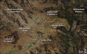
Wetland
A wetland is an area of land whose soil is saturated with water either permanently or seasonally. Wetlands are categorised by their characteristic vegetation, which is adapted to these unique soil conditions....
and riparian zone
Riparian zone
A riparian zone or riparian area is the interface between land and a river or stream. Riparian is also the proper nomenclature for one of the fifteen terrestrial biomes of the earth. Plant habitats and communities along the river margins and banks are called riparian vegetation, characterized by...
s. Several species of frogs are common in the "lost streams" basin and the northeasternmost part of the Snake River watershed, including the inland tailed frog, Northern leopard frog
Northern Leopard Frog
The Northern Leopard Frog is a species of leopard frog from the true frog family, native to parts of Canada and United States. It is the state amphibian of Minnesota and Vermont.-Physical description:...
, western toad
Western toad
The Western toad more commonly known as is a large toad species, between 5.6 and 13 cm long, of western North America. It has a white or cream dorsal stripe, and is dusky gray or greenish dorsally with skin glands concentrated within the dark blotches...
, Columbia spotted frog
Columbia Spotted Frog
The Columbia Spotted Frog, Rana luteiventris, is a North American species of frog. It is green to brown in color with spots on the dorsal surface. The belly and upper lip are white in color. Individuals can be distinguished from other Rana species by their shorter back legs, narrow snout and...
, long-toed salamander
Long-toed Salamander
The long-toed salamander is a mole salamander in the family Ambystomatidae. This species, typically 4.1–8.9 cm long when mature, is characterized by its mottled black, brown and yellow pigmentation, and its long outer fourth toe on the hind limbs...
, spadefoot toad
American spadefoot toads
Scaphiopodidae is a family of American spadefoot toads. They are native to southern Canada and USA south to southern Mexico. Scaphiopodidae is a small family, comprising only seven species....
. However, in the lower and middle portions of the Snake River watershed, several native species have been severely impacted by agriculture practices and the resulting non-native species supported by them. Introduced birds include the gray partridge, ring-necked pheasant, and chukar
Chukar
The Chukar Partridge or Chukar is a Eurasian upland gamebird in the pheasant family Phasianidae. It has been considered to form a superspecies complex along with the Rock Partridge, Philby's Partridge and Przevalski's Partridge and treated in the past as conspecific particularly with the first...
. Other non-native species include the bullfrog
Bullfrog
The American bullfrog , often simply known as the bullfrog in Canada and the United States, is an aquatic frog, a member of the family Ranidae, or “true frogs”, native to much of North America. This is a frog of larger, permanent water bodies, swamps, ponds, and lakes, where it is usually found...
, brown-headed cowbird
Brown-headed Cowbird
The Brown-headed Cowbird is a small brood parasitic icterid of temperate to subtropical North America. They are permanent residents in the southern parts of their range; northern birds migrate to the southern United States and Mexico in winter, returning to their summer habitat around March or...
, and European starling
European Starling
The Common Starling , also known as the European Starling or just Starling, is a passerine bird in the family Sturnidae.This species of starling is native to most of temperate Europe and western Asia...
, attracted by the construction of cities and towns.
Plants
The Snake River watershed includes a diversity of vegetation zones both past and present. A majority of the watershed was once covered with shrub-steppeShrub-steppe
Shrub-steppe is a type of low rainfall natural grassland. Shrub-steppes are distinguishable from deserts, which are too dry to support a noticeable cover of perennial grasses or other shrubs, while the shrub-steppe has sufficient moisture levels to support a cover of perennial grasses and/or...
grassland
Grassland
Grasslands are areas where the vegetation is dominated by grasses and other herbaceous plants . However, sedge and rush families can also be found. Grasslands occur naturally on all continents except Antarctica...
, most common in the Snake River Plain and also the Columbia Plateau in southeastern Washington. Riparian zones, wetlands and marshes once occurred along the length of the Snake River and its tributaries. In higher elevations, conifer forests, of which ponderosa pine
Ponderosa Pine
Pinus ponderosa, commonly known as the Ponderosa Pine, Bull Pine, Blackjack Pine, or Western Yellow Pine, is a widespread and variable pine native to western North America. It was first described by David Douglas in 1826, from eastern Washington near present-day Spokane...
is most common, dominate the landscape. The basin ranges from semi-desert to alpine climate
Alpine climate
Alpine climate is the average weather for a region above the tree line. This climate is also referred to as mountain climate or highland climate....
s, providing habitat for hundreds of species of plants. In the lowermost part of the watershed, in southeastern Washington, the Snake River is surrounded by an area called the Columbia Plateau Ecoprovince, which is now mostly occupied by irrigated farms. The rest of the Plateau area is characterized by low hills, dry lakes, and an arid, nearly desert climate.
The headwaters of the Snake River and the high mountains elsewhere in the watershed were historically heavily forested. These include aspen
Aspen
Populus section Populus, of the Populus genus, includes the aspen trees and the white poplar Populus alba. The five typical aspens are all native to cold regions with cool summers, in the north of the Northern Hemisphere, extending south at high altitudes in the mountains. The White Poplar, by...
, Douglas fir, and spruce fir, comprising about 20% of the historic watershed. At the base of mountains and in the Lost River basin, sagebrush
Sagebrush
Sagebrush is a common name of a number of shrubby plant species in the genus Artemisia native to western North America;Or, the sagebrush steppe ecoregion, having one or more kinds of sagebrush, bunchgrasses and others;...
was and is the predominant vegetation cover. Because of deforestation, up to one-fourth of the forests have been taken over by sagebrush, leaving the remaining forests to cover about 15% of the watershed. However, the lodgepole pine
Lodgepole Pine
Lodgepole Pine, Pinus contorta, also known as Shore Pine, is a common tree in western North America. Like all pines, it is evergreen.-Subspecies:...
has increased in number, taking over historic stands of other conifers. There are also up to 118 species of rare or endemic plants that occur in the Snake River watershed.
Salmon and anadromous fish
The Snake River was once one of the most important rivers for the spawning of anadromous fish—which are born in the headwaters of rivers, live in the ocean for most of their lives, and return to the river to spawn—in the United States.The river supported species including chinook salmon
Chinook salmon
The Chinook salmon, Oncorhynchus tshawytscha, is the largest species in the pacific salmon family. Other commonly used names for the species include King salmon, Quinnat salmon, Spring salmon and Tyee salmon...
, coho salmon
Coho salmon
The Coho salmon, Oncorhynchus kisutch, is a species of anadromous fish in the salmon family. Coho salmon are also known as silver salmon or "silvers". It is the state animal of Chiba, Japan.-Description:...
, and sockeye salmon
Sockeye salmon
Sockeye salmon , also called red salmon or blueback salmon in the USA, is an anadromous species of salmon found in the Northern Pacific Ocean and rivers discharging into it...
, as well as steelhead trout, white sturgeon
White sturgeon
The white sturgeon , also known as the Pacific sturgeon, Oregon sturgeon, Columbia sturgeon, Sacramento sturgeon, and California white sturgeon, is a sturgeon which lives along the west coast of North America from the Aleutian Islands to Central...
, and Pacific lamprey
Pacific lamprey
The Pacific lamprey is an anadromous parasitic lamprey from the Pacific Coast of North America and Asia. It is also known as the three tooth lamprey and tridentate lamprey.-Biology:...
. It is known that before the construction of dams on the river, there were three major chinook salmon runs in the Snake River; in the spring, summer and fall, totaling about 120,000 fish, and the sockeye salmon run was about 150,000. The historical barrier to fish migration on the Snake River was Shoshone Falls
Shoshone Falls
Shoshone Falls is a waterfall on the Snake River located approximately five miles east of Twin Falls, Idaho. Sometimes called the "Niagara of the West," Shoshone Falls is 212 feet high—45 feet higher than Niagara Falls—and flows over a rim 1,000 feet wide.A park overlooking the waterfall is...
, a waterfall that occurs as the Snake River passes through the Snake River Plain.

Swan Falls Dam
Swan Falls Dam is a concrete gravity type hydroelectric dam on the Snake River, in the U.S. state of Idaho. It is located near Murphy, Idaho.The dam was built in 1901 to generate electricity. It is the oldest hydroelectric dam on the Snake River. In the 1990s the original power plant was replaced...
was constructed on the middle Snake River upstream of Hells Canyon, the fifteen dams and reservoirs on the river have posed an increasing problem for migrating salmon. Agricultural lands and their resulting runoff have also had a significant impact on the success rate of migrating fish. Salmon can travel up the Snake River as far as Hells Canyon Dam
Hells Canyon Dam
Hells Canyon Dam is a concrete gravity dam on the Snake River in Hells Canyon on the Idaho-Oregon border. The dam impounds the Snake River in Hells Canyon Reservoir; its spillway elevation is above sea level....
, using the fish passage facilities of the four lower Snake River dams, leaving the Clearwater
Clearwater River (Idaho)
The Clearwater River is a river in north central Idaho, which flows westward from the Bitterroot Mountains along the Idaho-Montana border, and joins the Snake River at Lewiston. In October 1805, the Lewis and Clark Expedition descended the Clearwater River in dugout canoes, putting in at "Canoe...
, Grande Ronde
Grande Ronde River
The Grande Ronde River is a tributary of the Snake River, long, in northeastern Oregon and southeastern Washington in the United States. It drains an area southeast of the Blue Mountains and northwest of the Wallowa Mountains, on the Columbia Plateau...
and Salmon River
Salmon River (Idaho)
The Salmon River is located in Idaho in the northwestern United States. The Salmon is also known as The River of No Return. It flows for through central Idaho, draining and dropping more than between its headwaters, near Galena Summit above the Sawtooth Valley in the Sawtooth National...
s to sustain spawning salmon. Rising in several forks in the Clearwater Mountains
Clearwater Mountains
The Clearwater Mountains are part of the Rocky Mountains, located in the panhandle of Idaho in the Western United States. The mountains lie between the Salmon River and the Bitterroot Range and encompass an area of .- North Clearwater Mountains :...
of central Idaho, the Clearwater and Salmon River watersheds are nearly undeveloped with the enormous exception of Dworshak Dam
Dworshak Dam
Dworshak Dam is a hydroelectric, concrete gravity dam in Clearwater County, Idaho, United States on the North Fork Clearwater River. The dam is located northwest of the city of Orofino, and east of Lewiston. The dam is the highest straight-axis concrete dam in the Western Hemisphere and the 22nd...
on the North Fork Clearwater River
North Fork Clearwater River
The North Fork Clearwater River is a major tributary of the Clearwater River in the U.S. state of Idaho.From its headwaters in the Bitterroot Mountains of eastern Idaho, it flows southwest, north, then again southwest, and is dammed by the Dworshak Dam just above its mouth at the Clearwater in...
. The watershed of the Grande Ronde in northeastern Oregon is also largely undeveloped. The four reservoirs formed by the lower Snake River dams—Lake Sacagawea
Lake Sacajawea (Washington)
Lake Sacajawea is formed by the Ice Harbor Dam on the Snake River. It stretches from there upstream to the Lower Monumental Dam. It is named for Sacajawea, a Shoshone woman who accompanied Meriwether Lewis and William Clark during their exploration of the American West....
, Lake Herbert G. West
Lake Herbert G. West
Lake Herbert G. West is a reservoir formed by the Lower Monumental Dam. It extends up the Snake River for 28 miles to the tailwater of Little Goose Dam...
, Lake Bryan, and Lower Granite Lake—have also formed problems, as the downstream current in the pools is often not enough for the fish to sense, confusing their migration routes.
At the confluence of the Snake and Clearwater Rivers, young salmon that swim down from spawning gravels in the headwaters of the Clearwater River often delay their migrations because of a significant temperature difference. (Prior to the removal of Lewiston Dam on the main Clearwater and Grangeville Dam on the South Fork Clearwater, the Clearwater was completely unusable by migrating salmon.) Agricultural runoff and water held in reservoirs higher upstream on the Snake warm its waters as it flows through the Snake River Plain, so as the Snake meets the Clearwater, its average temperature is much higher. Directly below the confluence, the river flows into Lower Granite Lake, formed by Lower Granite Dam, the uppermost dam of the Lower Snake River Project. Paradoxically, the combination of these factors gives the young salmon further time to grow and to feed in Upper Granite Lake, so when they begin the migration to the Pacific Ocean, they often have a higher chance at survival, compared to those salmon who migrate to the ocean earlier.
Lower Snake River dam removal
A controversy has erupted since the late 20th century over the four lower Snake River dams, with the primary argument being that removing the dams would allow anadromous fish to reach the lower Snake River tributaries—the Clearwater River, the Tucannon RiverTucannon River
The Tucannon River is a river in southeastern Washington state that flows from headwaters in the Blue Mountains to a confluence with the Snake River upstream from Lyons Ferry Park and the mouth of the Palouse River. The Tucannon itself drains and is long...
and the Grande Ronde River
Grande Ronde River
The Grande Ronde River is a tributary of the Snake River, long, in northeastern Oregon and southeastern Washington in the United States. It drains an area southeast of the Blue Mountains and northwest of the Wallowa Mountains, on the Columbia Plateau...
—and spawn in much higher numbers. However, removal of the dams has been fiercely opposed by some groups in the Pacific Northwest. The controversy is highly political. On one side, “Conservationists, coastal fishing communities, the state of Oregon, and the Nez Perce tribe” that would sacrifice their economic gains for the sake of restoration of salmon. Against those pro-ecological restoration groups, “hydropower interests, aluminum industries, agribusiness, and political allies in Idaho, Washington and Montana” pursue economic benefits over natural world. The concern regarding to the lower Snake River dams is highly controversial, since the existence of dams threatens one of the iconic species in Pacific Northwest. At the same time, dams also carry important economic and social significance to the community; Because much of the electricity in the Northwest comes from dams, removing the four dams would create a hole in the energy grid that would not be immediately replaceable.
The lower Snake River dams provide enough energy to power a city the size of Seattle, Washington
Seattle, Washington
Seattle is the county seat of King County, Washington. With 608,660 residents as of the 2010 Census, Seattle is the largest city in the Northwestern United States. The Seattle metropolitan area of about 3.4 million inhabitants is the 15th largest metropolitan area in the country...
. These dams are run of the river dams, which means that they rely entirely on the amount of snowpack and the rate of runoff. Because these dams are rather ineffective, removal would not create a long term energy shortage, but it would take time to make up for the loss. Navigation on the lower Snake would also suffer, as submerged riffles, rapids and islands would be exposed by the removal of the dams. Irrigation pumps for fields in southeastern Washington would also have to reach further to access the water of the Snake River. However, aside from restoring salmon runs, dam removal proponents argue that the power is replaceable, that the grain transportation system could be replaced by railroads, and that only one of the four reservoirs supplies irrigation water. Irrigators in the Snake River Plain would likely need to allow less water into the Snake River during low flow in order to create a current in the four lower reservoirs, and recreation and tourism would likely benefit.
In response to conflicts, a bill has been introduced in the U.S. Congress proposing the study of the feasibility of removing these four lower dams. The issue of dam removal was not in the recovery plan set forth by the Obama Administration in September 2009. The plan instead recommended monitoring the effects of climate change and expanding habitat improvement efforts, leaving dam removal as “a last resort” contingent upon a multiyear study of the dams. In February 2010 U.S. Circuit Judge James Redden deemed this plan to be inadequate and gave NOAA three months to formulate a better plan. The plan was resubmitted in May 2010 with few substantial changes and has faced strong opposition from salmon advocates. A final decision from Judge Redden is expected in the spring of 2011.
The impacts of tourism and recreational activities in the lower Snake River area are highly beneficial. Removal of the dam would create a free-flowing river where recreational activities and tourism could take place. Restoring the lower Snake River would return many rapids, beaches and islands, and provide Washington State with 140 miles (225.3 km) of big river recreation for water recreationists including jet boaters, kayakers and canoeists. Boating, kayaking, hunting, wildlife watching, hiking, camping and other related activities could bring an additional $310.5 million in non-fishing recreational income per year. According to a 2000 study for the Army Corps of Engineers – that’s about 10 times the economic value of current reservoir-based recreation on the lower Snake. The economic benefits could also be furthered by the improved quality of life that the removal of the dam would bring, drawing new businesses and residents to Snake River communities, help keep existing residents in town, and help increase property values. The dam removal and restoration effort itself could prove to be a tourism opportunity, as people are drawn to witness and learn about this historic event.
In addition to an increase in recreation and tourism, the economic benefit of reestablishing fish stocks would eventually outweigh the hydropower generated by the dams. The fish that migrate through the Lower Snake River are the Snake River Sockeye Salmon. Prior to dam construction these fish had one of the longest freshwater migrations on the planet, traveling over 1000 miles (1,609.3 km) from the Pacific Ocean to Redfish Lake, Idaho, which is now blocked off because of these four dams. The Snake River has the highest, coolest, largest, best-protected habitat in the lower 48 states which would allow these salmon to thrive. The Snake River sockeye salmon are among the most resilient fish to warming and climate change because of their genetic diversity and long evolution process. Because of their long migration residing in Redfish Lake with a surface elevation of 6547 ft (1,995.5 m), these fish are well adapted and with a chance and place to spawn, these fish will rebound to historic numbers, allowing for positive economic opportunity (i.e. fishing).
The number of Wild Salmon is on the decline “The total annual run of all anadromous salmon in the basin, estimated at 10 to 16 million fish before European settlement, has declined to around one million fish, of which approximately 80% or more are now produced artificially in hatcheries.” Many argue that the best way to ensure these salmon are protected is the removal of dams, especially those four located in the lower Snake River. The removal of these dams will improve water conditions and water flow thus benefiting all thirteen species of stock salmon that migrate through the Columbia River. Although the dams do provide clean energy to Washington State, their removal will not hurt or inhibit the use of wind power.
The benefits of removing the lower Snake River dams are strong and should not be ignored or dismissed. Juvenile salmon, migrating through the lower Snake River dams reach mortality rates as high as 90%. An extensive modeling effort of mortality analysis in 2000, showed that the lower four dams on the Snake river were the most significant factor preventing recovery. Having to pass through eight dams is simply too hard for salmon, and removing these lower four dams would dramatically increase their numbers. Removing the dams will be beneficial to all 13 endangered species of salmon. Improved water quality and flow that would result from dam removal, would benefit all of the ESA listed species on the Columbia and Snake rivers. One of the conservation efforts is the Lower Snake River Compensation Plan. This plan looks at the dams and found that these dams prevent the passage of many salmon and so we are now looking towards restoration efforts through hatcheries. The Lower Snake River Compensation Plan is looking to “compensate for the loss of 15% of the downstream-migrating juvenile salmon and steelhead. This amounts to a cumulative loss of 48% of the pre-dam runs.”. Through this plan we hope to increase the overall juvenile salmon runs.
Restoring salmon to the Snake River through the removal of the lower four dams has is a huge benefit. However, there are two other issues which should also be looked at in the consideration of the removal of these dams. The first benefit is the future safety of nearby towns to the these dams. Each year more sediment is eroded and is carried behind the dams. The Lower Granite Dam is 55% full of sediment, and each year that passes brings the nearby towns of Lewiston and Clarkston closer to a devastating flood. While other solutions have been thought of, they can only postpone such a flood, because the sediment will eventually pile up behind the dam once again. Many farmers are worried that the removal of the dams will deplete the water they use for irrigation. However this is not the case. In fact, intake pipes can be used instead of dams and take the water directly from the river. Author Steven Hawley uses Lewiston, Idaho as an example of a town threatened by dams. In a lecture at the University of Washington, Hawley described how Lewiston was moving closer to being flooded each year due to sediment buildup. Levees built to contain the water block the view of the river. Yet, Hawley said, many of the residents didn't see the immediacy of the situation, and he used their resistance to change as an example of the problems facing dam removal everywhere. Removing dams and taking water directly from rivers saves water because a free flowing river will evaporate less than a reservoir. By piping water directly to the farmers, a lot of water that would be normally evaporated, remains in the river.
As described in David Montgomery’s book, King of Fish, the Columbia River basin only supports about seven salmon for every fifty salmon the basin had supported one-hundred-and-fifty years ago. Only one or two of those fish are wild and non-hatchery raised as well. There are numerous competing uses of the Columbia River, such as hydropower, flood control, navigation, irrigation agriculture, and salmon fishing. However, Columbia River management currently benefits certain interests and strategies are inadequate to restore salmon populations. Dam removal is necessary for restoration and recovery of salmon, but politics get in the way. Save Our Wild Salmon website also recommends removing the four lower Snake River dams, which they believe would enable salmon to rebound with more habitat and easier passage on their journey to the ocean. The website criticizes the government for spending eight million dollars on salmon recovery that has failed. In addition the Save Our Wild Salmon group disapproves of the government for getting around legal requirements and politicizing science - ignoring sound science.
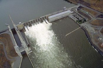
Though dams significantly reduce the amount of salmon that return to the Pacific from the Columbia, they also play a large role in the amount of clean energy produced by Washington State. Because of the amount of hydropower Washington State uses, it's carbon footprint is one of the lowest in the country. Though salmon are a great resource and dams often have many negative effects on their habitat, dams of the Columbia Basin are not all bad. Because there are a lot of stakeholders in the Columbia River Basin, extreme solutions will resolve the conflict between dam and salmon supporters. Instead, sacrifices need to be made by all parties. Some dams need to be modified to become more salmon-friendly and to increase stock diversity. Additional ladders and more spill water would help increase the salmon return. Also, salmon supporters have to realize that the dams provide clean energy. Completely destroying them involves a detailed plan of Adaptive Management that doesn’t move so fast that salmon resilience does not remain intact.
According to a study on the ecology of dam removal by Angela Bednarek a Ph.D. candidate at the University of Pennsylvania, there may be some short-term negative impacts on river quality after dam removal, but the long-term impacts are extremely positive and generally result in a significant restoration in river processes and quality. Furthermore, through careful planning many negative short-term effects can be mitigated or reduced. The ecological benefits of removing the Snake River dams are quite obvious yet the controversy continues. According to an article by the Bonneville Power Administration, the Snake River dams are an important source of clean energy for the region and they believe the benefits of clean energy far outweigh those of river restoration.
While there are various issues that would arise with the four lower Snake River dams’ removal, there are many flaws in their current state. The Lower Granite dam has been collecting sediment over the years and is currently 55% full. This occurrence is lowering the dam’s capacity to function efficiently while concurrently increasing the risk of flooding. There are more effective methods to obtain energy, but as stated earlier, an immediate transition is improbable. However, the dams have incurred a greater reliance on hatcheries as dam-caused mortality numbers have significantly offset the salmon run populations. Unfortunately, those said hatcheries were unsuccessful in maintaining spawning runs and those within the Snake River Basin did far worse in comparison to hatcheries in other locations. Factors such as these deter decisions from being made and keep the issue controversial.
The four dams on the lower Snake River have been in place since 1975 and a great deal of controversy has always surrounded the implementation of these dams. The primary concern for those who oppose the dams is the drastic decline in salmon populations since the implementation of the dams. As Steven Hawley states in his article on the Columbia salmon plan, “Mortality for out-migrating juvenile salmon topped 90 percent for some Snake River fish". Although many people in support of the Columbia salmon plan state that other factors such as climate change contribute the most to declining salmon populations, and that dam removal will not be an effective solution, in an article about the myths and facts of Lower Snake dam removal on the Save Our Wild Salmon website, it states: “In fact, the current federal salmon plan permits the federal dams to kill more than 90% of some of these salmon”. Furthermore, in a study conducted by the U.S. Army Corps of Engineers, it was revealed that “the removal of the four lower Snake River dams would actually decrease total air emissions by seven tons per year from the transportation sector.” The Snake River Controversy is an ongoing conflict and it will not be resolved until a greater degree of transparency is reached by the government, and until biological and ecological values are placed above purely economic concerns.
Tributaries
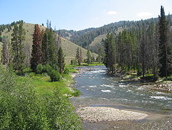
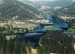
Tributary
A tributary or affluent is a stream or river that flows into a main stem river or a lake. A tributary does not flow directly into a sea or ocean...
, most of which are in the mountainous regions of the basin. The largest by far is the Clearwater River
Clearwater River (Idaho)
The Clearwater River is a river in north central Idaho, which flows westward from the Bitterroot Mountains along the Idaho-Montana border, and joins the Snake River at Lewiston. In October 1805, the Lewis and Clark Expedition descended the Clearwater River in dugout canoes, putting in at "Canoe...
, which drains 9000 square miles (23,309.9 km²) in north central Idaho. Many of the rivers that flow into the Snake River Plain from the north sink into the Snake River Aquifer, but still contribute their water to the river. Aside from rivers, the Snake is fed by many significant spring
Spring (hydrosphere)
A spring—also known as a rising or resurgence—is a component of the hydrosphere. Specifically, it is any natural situation where water flows to the surface of the earth from underground...
s, many of which arise from the aquifer on the west side of the plain.
| Name | Length | Watershed size | Bank |
|---|---|---|---|
| Heart River Heart River (Wyoming) The Heart River is a river in the U.S. state of Wyoming, tributary to the Snake River. Its entire course is contained inside Yellowstone National Park. The river rises on the Continental Divide, in the Rocky Mountains, a few miles southeast of Yellowstone Lake... |
8.5 miles (13.7 km) | Right | |
| Lewis River Lewis River (Wyoming) The Lewis River is an tributary of the Snake River. The entire course of the river is located within the boundaries of Yellowstone National Park in Wyoming. The river is named for Meriwether Lewis, commander of the Lewis and Clark Expedition.... |
12 miles (19.3 km) | Right | |
| Gros Ventre River Gros Ventre River The Gros Ventre River is a tributary of the Snake River in the state of Wyoming. It rises in the Gros Ventre Wilderness in western Wyoming, and joins the Snake River in the Jackson Hole valley. In 1925, the massive Gros Ventre landslide dammed the river and formed Lower Slide Lake... |
642 square miles (1,662.8 km²) | Left | |
| Hoback River Hoback River The Hoback River, also called the Fall River, is an approximately -long tributary of the Snake River in the U.S. state of Wyoming. It rises in the southern Rocky Mountains of Wyoming and flows northeast through the Teton National Forest, before turning northwest to join the Snake just downstream of... |
55 miles (88.5 km) | 600 square miles (1,554 km²) | Left |
| Greys River Greys River The Greys River is a tributary of the Snake River, flowing through western Wyoming in the United States. The river is about long, starting high up in the Wyoming Range, south of the town of Alpine in Lincoln County. The river eventually flows into the Snake River in the Snake River Canyon,... |
65 miles (104.6 km) | 800 square miles (2,072 km²) | Left |
| Salt River Salt River (Wyoming) The Salt River is an river draining a valley in Lincoln County in western Wyoming. It is named for several exposed beds of salt and briny salt springs of up 60% pure salt in Idaho that drains into the Salt River via Stump Creek. The Salt River valley was a popular destination for Indians and later... |
70 miles (112.7 km) | 890 square miles (2,305.1 km²) | Left |
| Henrys Fork (Snake River) | 110 miles (177 km) | 3212 square miles (8,319 km²) | Right |
| Portneuf River Portneuf River (Idaho) The Portneuf River is a tributary of the Snake River in southeastern Idaho in the United States. It drains a ranching and farming valley in the mountains southeast of the Snake River Plain... |
96 miles (154.5 km) | 1329 square miles (3,442.1 km²) | Left |
| Raft River Raft River The Raft River is a tributary of the Snake River located in northern Utah and southern Idaho in the United States. It is part of the Columbia River Basin.-Course:... |
1506 square miles (3,900.5 km²) | Left | |
| Malad River Malad River The Malad River is a tributary of the Snake River in Idaho in the United States. It is formed by the confluence of the Big Wood River and the Little Wood River near Gooding. From there the river flows south and west for to join the Snake River near Hagerman.... |
11.5 miles (18.5 km) | 3000 square miles (7,770 km²) | Right |
| Salmon Falls Creek Salmon Falls Creek Salmon Falls Creek is a tributary of the Snake River, flowing from northern Nevada into Idaho in the United States. Formed in high mountains at the northern edge of the Great Basin, Salmon Falls Creek flows northwards , draining an arid and mountainous basin of... |
218 miles (350.8 km) | 2082 square miles (5,392.4 km²) | Left |
| Bruneau River Bruneau River The Bruneau River is a tributary of the Snake River, in the U.S. states of Idaho and Nevada. It runs through a narrow canyon cut into ancient lava flows in southwestern Idaho... |
3305 square miles (8,559.9 km²) | Left | |
| Boise River Boise River The Boise River is a tributary of the Snake River in the northwestern United States. It drains a rugged portion of the Sawtooth Range in southwestern Idaho northeast of Boise, as well as part of the western Snake River Plain... |
75 miles (120.7 km) | 4100 square miles (10,619 km²) | Right |
| Owyhee River Owyhee River The Owyhee River is a tributary of the Snake River located in northern Nevada, southwestern Idaho and southeastern Oregon in the United States. It is long. The river's drainage basin is in area, one of the largest subbasins of the Columbia Basin... |
280 miles (450.6 km) | 11049 square miles (28,616.8 km²) | Left |
| Malheur River Malheur River The Malheur River is a tributary of the Snake River in eastern Oregon in the United States. It drains a high desert area, between the Harney Basin and the Blue Mountains and the Snake.... |
165 miles (265.5 km) | 4700 square miles (12,172.9 km²) | Right |
| Payette River Payette River The Payette River is an river in southwestern Idaho and is a major tributary of the Snake River.Its headwaters originate in the Sawtooth and Salmon River Mountains at elevations over... |
62 miles (99.8 km) | 3240 square miles (8,391.6 km²) | Right |
| Weiser River Weiser River The Weiser River is a tributary of the Snake River in western Idaho in the United States. It drains a mountainous area of consisting primarily of low rolling foothills intersected by small streams south and east of Hells Canyon along the Idaho-Oregon border.... |
90 miles (144.8 km) | 1660 square miles (4,299.4 km²) | Right |
| Burnt River Burnt River (Oregon) The Burnt River is a tributary of the Snake River in eastern Oregon, United States. It enters the Snake near Huntington, Oregon, at a point upstream of the Powder River and downstream of the Malheur River, slightly more than from the Snake's confluence with the Columbia River... |
50 miles (80.5 km) | Left | |
| Salmon River Salmon River (Idaho) The Salmon River is located in Idaho in the northwestern United States. The Salmon is also known as The River of No Return. It flows for through central Idaho, draining and dropping more than between its headwaters, near Galena Summit above the Sawtooth Valley in the Sawtooth National... |
425 miles (684 km) | 14000 square miles (36,259.8 km²) | Right |
| Grande Ronde River Grande Ronde River The Grande Ronde River is a tributary of the Snake River, long, in northeastern Oregon and southeastern Washington in the United States. It drains an area southeast of the Blue Mountains and northwest of the Wallowa Mountains, on the Columbia Plateau... |
212 miles (341.2 km) | 4000 square miles (10,360 km²) | Left |
| Clearwater River Clearwater River (Idaho) The Clearwater River is a river in north central Idaho, which flows westward from the Bitterroot Mountains along the Idaho-Montana border, and joins the Snake River at Lewiston. In October 1805, the Lewis and Clark Expedition descended the Clearwater River in dugout canoes, putting in at "Canoe... |
80 miles (128.7 km) | 9645 square miles (24,980.4 km²) | Right |
| Tucannon River Tucannon River The Tucannon River is a river in southeastern Washington state that flows from headwaters in the Blue Mountains to a confluence with the Snake River upstream from Lyons Ferry Park and the mouth of the Palouse River. The Tucannon itself drains and is long... |
70 miles (112.7 km) | 503 square miles (1,302.8 km²) | Left |
| Palouse River Palouse River The Palouse River is a tributary of the Snake River located in the U.S. states of Washington and Idaho. It flows for southwestwards, primarily through the Palouse region of southeastern Washington... |
140 miles (225.3 km) | 3303 square miles (8,554.7 km²) | Right |
See also
- Snake River Plain (ecoregion)Snake River Plain (ecoregion)The Snake River Plain ecoregion is a Level III ecoregion designated by the United States Environmental Protection Agency in the U.S. states of Idaho and Oregon. It follows the Snake River across Idaho, stretching roughly from the Wyoming border to Eastern Oregon in the xeric intermontane west...
- Lost streams of Idaho
- Angling in Yellowstone National ParkAngling in Yellowstone National ParkAngling in Yellowstone National Park is a major reason many visitors come to the park each year and since it was created in 1872, the park has drawn anglers from around the world to fish its waters. In 2006, over 50,000 park fishing permits were issued to visitors...
- Fishes of Yellowstone National ParkFishes of Yellowstone National ParkYellowstone National Park is home to 13 native Fish species and six introduced or non-native species. Angling for trout has been a pastime in the park since its creation and trout species dominate the fish inhabiting the park. When the park was created in 1872, 40% of the park's waters were barren...
- List of crossings of the Snake River
- Snake River PlainSnake River PlainThe Snake River Plain is a geologic feature located primarily within the state of Idaho in the United States of America. It stretches about westward from northwest of the state of Wyoming to the Idaho-Oregon border. The plain is a wide flat bow-shaped depression, and covers about a quarter of Idaho...
- List of Idaho rivers
- List of rivers of Oregon
- List of longest streams of Oregon
- List of Washington rivers
- List of Wyoming rivers
- List of National Wild and Scenic Rivers
- List of tributaries of the Columbia River
- List of longest rivers of the United States (by main stem)
External links
- Idaho Power
- Wild and Scenic Snake River - National Wild and Scenic Rivers System
- The Snake River in Grand Teton National Park
- List of dams on the Snake River