

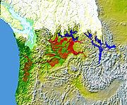
Missoula Floods
Encyclopedia
Flood
A flood is an overflow of an expanse of water that submerges land. The EU Floods directive defines a flood as a temporary covering by water of land not normally covered by water...
s that swept periodically across eastern Washington and down the Columbia River Gorge
Columbia River Gorge
The Columbia River Gorge is a canyon of the Columbia River in the Pacific Northwest of the United States. Up to deep, the canyon stretches for over as the river winds westward through the Cascade Range forming the boundary between the State of Washington to the north and Oregon to the south...
at the end of the last ice age
Ice age
An ice age or, more precisely, glacial age, is a generic geological period of long-term reduction in the temperature of the Earth's surface and atmosphere, resulting in the presence or expansion of continental ice sheets, polar ice sheets and alpine glaciers...
. The glacial flood events have been researched since the 1920s. These glacial lake outburst flood
Glacial lake outburst flood
A glacial lake outburst flood is a type of outburst flood that occurs when the dam containing a glacial lake fails. The dam can consist of glacier ice or a terminal moraine...
s were the result of periodic sudden ruptures of the ice dam on the Clark Fork River that created Glacial Lake Missoula
Glacial Lake Missoula
Glacial Lake Missoula was a prehistoric proglacial lake in western Montana that existed periodically at the end of the last ice age between 15,000 and 13,000 years ago...
. After each ice dam rupture, the waters of the lake would rush down the Clark Fork and the Columbia River
Columbia River
The Columbia River is the largest river in the Pacific Northwest region of North America. The river rises in the Rocky Mountains of British Columbia, Canada, flows northwest and then south into the U.S. state of Washington, then turns west to form most of the border between Washington and the state...
, inundating much of eastern Washington and the Willamette Valley
Willamette Valley
The Willamette Valley is the most populated region in the state of Oregon of the United States. Located in the state's northwest, the region is surrounded by tall mountain ranges to the east, west and south and the valley's floor is broad, flat and fertile because of Ice Age conditions...
in western Oregon
Oregon
Oregon is a state in the Pacific Northwest region of the United States. It is located on the Pacific coast, with Washington to the north, California to the south, Nevada on the southeast and Idaho to the east. The Columbia and Snake rivers delineate much of Oregon's northern and eastern...
. After the rupture, the ice would reform, recreating Glacial Lake Missoula once again. Geologists estimate that the cycle of flooding and reformation of the lake lasted an average of 55 years and that the floods occurred several times over the 2,000 year period between 15,000 and 13,000 years ago. U.S. Geological Survey hydrologist Jim O'Connor and Spanish Center of Environmental Studies scientist Gerard Benito have found evidence of at least twenty-five massive floods, the largest discharging ~10 cubic kilometers per hour. Alternate estimates for the peak flow rate of the largest flood include 17 cubic kilometers per hour and range up to 60 cubic kilometers per hour. The maximum flow speed approached 36 meters/second (130 km/h or 80 mph).
Flood hypothesis proposed
GeologistGeologist
A geologist is a scientist who studies the solid and liquid matter that constitutes the Earth as well as the processes and history that has shaped it. Geologists usually engage in studying geology. Geologists, studying more of an applied science than a theoretical one, must approach Geology using...
J Harlen Bretz
J Harlen Bretz
J Harlen Bretz was an American geologist, best known for his research that led to the acceptance of the Missoula Floods, and also for his work on caves. He was born to Oliver Joseph Bretz and Rhoda Maria Howlett, farmers in Saranac, Michigan, as the oldest of five children...
first recognized evidence of the catastrophic floods, which he called the Spokane Floods, in the 1920s. He was researching the Channeled scablands
Channeled scablands
The Channeled Scablands are a unique geological erosion feature in the U.S. state of Washington. They were created by the cataclysmic Missoula Floods that swept periodically across eastern Washington and down the Columbia River Plateau during the Pleistocene epoch. Geologist J Harlen Bretz coined...
in Eastern Washington
Eastern Washington
Eastern Washington is the portion of the U.S. state of Washington east of the Cascade Range. The region contains the city of Spokane , the Tri-Cities, the Columbia River and the Grand Coulee Dam, the Hanford Nuclear Reservation and the fertile farmlands of the Yakima Valley and the...
, the Columbia Gorge and the Willamette Valley
Willamette Valley
The Willamette Valley is the most populated region in the state of Oregon of the United States. Located in the state's northwest, the region is surrounded by tall mountain ranges to the east, west and south and the valley's floor is broad, flat and fertile because of Ice Age conditions...
of Oregon
Oregon
Oregon is a state in the Pacific Northwest region of the United States. It is located on the Pacific coast, with Washington to the north, California to the south, Nevada on the southeast and Idaho to the east. The Columbia and Snake rivers delineate much of Oregon's northern and eastern...
. In the summer of 1922, and for the next seven years, Bretz conducted field research of the Columbia River Plateau
Columbia River Plateau
The Columbia Plateau is a geologic and geographic region that lies across parts of the U.S. states of Washington, Oregon, and Idaho. It is a wide flood basalt plateau between the Cascade Range and the Rocky Mountains, cut through by the Columbia River...
. He had been interested in unusual erosion
Erosion
Erosion is when materials are removed from the surface and changed into something else. It only works by hydraulic actions and transport of solids in the natural environment, and leads to the deposition of these materials elsewhere...
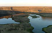
features in the area since 1910 after seeing a newly published topographic map of the Potholes Cataract
Dry Falls
Dry Falls is a 3.5 mile long scalloped precipice in central Washington, on the opposite side of the Upper Grand Coulee from the Columbia River, and at the head of the Lower Grand Coulee. Ten times the size of Niagara, Dry Falls is thought to be the greatest known waterfall that ever existed...
. Bretz coined the term Channeled Scablands
Channeled scablands
The Channeled Scablands are a unique geological erosion feature in the U.S. state of Washington. They were created by the cataclysmic Missoula Floods that swept periodically across eastern Washington and down the Columbia River Plateau during the Pleistocene epoch. Geologist J Harlen Bretz coined...
in 1923 to describe the area near the Grand Coulee
Grand Coulee
The Grand Coulee is an ancient river bed in the U.S. state of Washington. This National Natural Landmark stretches for about sixty miles southwest from Grand Coulee Dam to Soap Lake, being bisected by Dry Falls into the Upper and Lower Grand Coulee....
, where massive erosion had cut through basalt
Basalt
Basalt is a common extrusive volcanic rock. It is usually grey to black and fine-grained due to rapid cooling of lava at the surface of a planet. It may be porphyritic containing larger crystals in a fine matrix, or vesicular, or frothy scoria. Unweathered basalt is black or grey...
deposits. Bretz published a paper in 1923, arguing that the channeled scablands
Channeled scablands
The Channeled Scablands are a unique geological erosion feature in the U.S. state of Washington. They were created by the cataclysmic Missoula Floods that swept periodically across eastern Washington and down the Columbia River Plateau during the Pleistocene epoch. Geologist J Harlen Bretz coined...
in Eastern Washington
Eastern Washington
Eastern Washington is the portion of the U.S. state of Washington east of the Cascade Range. The region contains the city of Spokane , the Tri-Cities, the Columbia River and the Grand Coulee Dam, the Hanford Nuclear Reservation and the fertile farmlands of the Yakima Valley and the...
were caused by massive flooding in the distant past.
Bretz's view, which was seen as arguing for a catastrophic
Catastrophism
Catastrophism is the theory that the Earth has been affected in the past by sudden, short-lived, violent events, possibly worldwide in scope. The dominant paradigm of modern geology is uniformitarianism , in which slow incremental changes, such as erosion, create the Earth's appearance...
explanation of the geology, ran against the prevailing view of uniformitarianism
Uniformitarianism (science)
In the philosophy of naturalism, the uniformitarianism assumption is that the same natural laws and processes that operate in the universe now, have always operated in the universe in the past and apply everywhere in the universe. It has included the gradualistic concept that "the present is the...
, and Bretz's views were initially held in disregard. The Geological Society of Washington, D.C
Geological Society of America
The Geological Society of America is a nonprofit organization dedicated to the advancement of the geosciences. The society was founded in New York in 1888 by Alexander Winchell, John J. Stevenson, Charles H. Hitchcock, John R. Proctor and Edward Orton and has been headquartered at 3300 Penrose...
invited the young Bretz to present his previously published research at a January 12, 1927 meeting where several other geologists presented competing theories. Another geologist at the meeting, J.T. Pardee
Joseph Pardee
Joseph T. Pardee was a U.S. geologist who worked for the U.S. Geological Survey, and contributed to the understanding of the origin of the Channeled scablands. He discovered the trail of evidence left by Glacial Lake Missoula, a lake created by an ice dam 23 miles wide and half a mile high during...
, had worked with Bretz and had evidence of an ancient glacial lake
Proglacial lake
In geology, a proglacial lake is a lake formed either by the damming action of a moraine or ice dam during the retreat of a melting glacier, or by meltwater trapped against an ice sheet due to isostatic depression of the crust around the ice...
that lent credence to Bretz's theories. Bretz defended his theories and this kicked off an acrimonious forty year debate over the origin of the Scablands. Both Pardee and Bretz continued their research over the next 30 years, collecting and analyzing evidence that led him to identify Lake Missoula as the source of the Spokane Flood and creator of the Channeled Scablands.
After J.T. Pardee studied the canyon of the Flathead River
Flathead River
The Flathead River, in the northwestern part of the U.S. state of Montana, originates in the Rocky Mountains near Glacier National Park and flows southwest into Flathead Lake, then after a journey of , empties into the Clark Fork. The river is part of the Columbia River drainage basin, as the Clark...
, he estimated that flood waters in excess of 45 miles per hour (20.1 m/s) would be required to roll the largest of the boulders moved by the flood. He estimated the water flow was nine cubic miles per hour, more than the combined flow of every river in the world. Estimates place the flow at ten times the flow of all current rivers combined.
The Missoula Floods have also been referred to as the Bretz Floods in honor of Bretz.
Flood initiation
As the depth of the water in Lake Missoula increased, the pressure at the bottom increased enough to lower the freezing point of water below the temperature of the ice forming the dam. This allowed liquid water to seep into minuscule cracks present in the ice dam. Over a period of time, the friction from water flowing through these cracks generated enough heat to melt the ice walls and enlarge the cracks. This allowed more water to flow through the cracks, generating more heat, allowing even more water to flow through the cracks. This feedback cycle eventually weakened the ice dam so much that it could no longer support the pressure of the water behind it, and it failed catastrophically. This same process triggered a similar event, a jökulhlaup, in IcelandIceland
Iceland , described as the Republic of Iceland, is a Nordic and European island country in the North Atlantic Ocean, on the Mid-Atlantic Ridge. Iceland also refers to the main island of the country, which contains almost all the population and almost all the land area. The country has a population...
on November 5, 1996.
Flood events
As the water emerged from the Columbia River gorge, it backed up again at the 1 miles (1.6 km) wide narrows near Kalama, WashingtonKalama, Washington
Kalama is a city in Cowlitz County, Washington, United States. It is part of the 'Longview, Washington Metropolitan Statistical Area'. The population was 2,344 at the 2010 census.-History:...
. Some temporary lakes rose to an elevation of more than 400 ft (121.9 m), flooding the Willamette Valley to Eugene, Oregon
Eugene, Oregon
Eugene is the second largest city in the U.S. state of Oregon and the seat of Lane County. It is located at the south end of the Willamette Valley, at the confluence of the McKenzie and Willamette rivers, about east of the Oregon Coast.As of the 2010 U.S...
and beyond. Iceberg rafted glacial erratic
Glacial erratic
A glacial erratic is a piece of rock that differs from the size and type of rock native to the area in which it rests. "Erratics" take their name from the Latin word errare, and are carried by glacial ice, often over distances of hundreds of kilometres...
s and erosion features are evidence of these events. Lake-bottom sediments deposited by the Missoula Floods are the primary reason for the agricultural richness of the Willamette Valley.
After analysis and controversy, geologists now believe that there were 40 or more separate floods, although the exact source of the water is still being debated. The peak flow of the floods is estimated to be 40 to 60 cubic kilometers per hour (9.5 to 15 cubic miles per hour). The maximum flow speed approached 36 meters/second (130 km/h or 80 mph). Up to 1.9×10¹⁹ joules of potential energy were released by each flood (the equivalent of 4500 megatons of TNT
TNT equivalent
TNT equivalent is a method of quantifying the energy released in explosions. The ton of TNT is a unit of energy equal to 4.184 gigajoules, which is approximately the amount of energy released in the detonation of one ton of TNT...
). The cumulative effect of the floods was to excavate 210 cubic kilometres (50.4 cu mi) of loess, sediment and basalt from the channeled scablands
Channeled scablands
The Channeled Scablands are a unique geological erosion feature in the U.S. state of Washington. They were created by the cataclysmic Missoula Floods that swept periodically across eastern Washington and down the Columbia River Plateau during the Pleistocene epoch. Geologist J Harlen Bretz coined...
of eastern Washington and to transport it downstream.
Multiple flood hypothesis
The multiple flood hypothesis was first proposed by R.B. Waitt, Jr., in 1980. Waitt argued for a sequence of multiple floods — 40 or more. Waitt's proposal was based mainly on analysis from glacial lake bottom deposits in Ninemile Creek and the flood deposits in Burlingame Canyon. His most compelling argument for separate floods was that the Touchet bed deposits from two successive floods were found to be separated by two layers of volcanic ash (tephraTephra
200px|thumb|right|Tephra horizons in south-central [[Iceland]]. The thick and light coloured layer at center of the photo is [[rhyolitic]] tephra from [[Hekla]]....
) with the ash separated by a fine layer of windblown dust deposits, located in a thin layer located between sediment layers ten rhythmite
Rhythmite
A rhythmite consists of layers of sediment or sedimentary rock which are laid down with an obvious periodicity and regularity. They may be created by annual processes such as seasonally varying deposits reflecting variations in the runoff cycle, by shorter term processes such as tides, or by longer...
s below the top of the Touchet beds (see picture). The two layers of volcanic ash are separated by 1–10 cm of airborne nonvolcanic silt. The tephra is Mount St. Helens
Mount St. Helens
Mount St. Helens is an active stratovolcano located in Skamania County, Washington, in the Pacific Northwest region of the United States. It is south of Seattle, Washington and northeast of Portland, Oregon. Mount St. Helens takes its English name from the British diplomat Lord St Helens, a...
ash that fell in eastern Washington
Eastern Washington
Eastern Washington is the portion of the U.S. state of Washington east of the Cascade Range. The region contains the city of Spokane , the Tri-Cities, the Columbia River and the Grand Coulee Dam, the Hanford Nuclear Reservation and the fertile farmlands of the Yakima Valley and the...
. By analogy, since there were 40 layers with comparable characteristics at Burlingame Canyon, Waitt argued they all could be considered to have similar separation in deposition time.
Controversy over number and source of floods
The controversy whether the Channeled Scabland landforms were formed mainly by multiple periodic floods or by a single grand-scale cataclysmic flood from late Pleistocene Glacial Lake Missoula or from an unidentified Canadian source continued through 1999. Shaw’s team of geologists reviewed the sedimentary sequences of the Touchet beds and concluded that the sequences do not automatically imply multiple floods separated by decades or centuries. Rather, they proposed that sedimentation in the Glacial Lake Missoula basin was the result of jökulhlaupJökulhlaup
A jökulhlaup is a glacial outburst flood. It is an Icelandic term that has been adopted by the English language. It originally referred to the well-known subglacial outburst floods from Vatnajökull, Iceland which are triggered by geothermal heating and occasionally by a volcanic subglacial...
s draining into Lake Missoula from British Columbia to the north. Further, Shaw’s team proposed the scabland flooding might have partially originated from an enormous subglacial reservoir that extended over much of central British Columbia, particularly including the Rocky Mountain Trench, which may have discharged by several paths including one path through Lake Missoula. This discharge, if occurring concurrently with the breach of the Lake Missoula ice dam, would have provided significantly larger volumes of water. Further, Shaw and team proposed that the rhythmic Touchet beds are the result of multiple pulses, or surges, within a single larger flood.
In 2000, a team led by Komatsu simulated the floods numerically with a 3-dimensional hydraulic model. They based the Glacial Lake Missoula discharge rate on the rate predicted for the Spokane Valley–Rathdrum Prairie immediately downstream of Glacial Lake Missoula
Glacial Lake Missoula
Glacial Lake Missoula was a prehistoric proglacial lake in western Montana that existed periodically at the end of the last ice age between 15,000 and 13,000 years ago...
, for which a number of previous estimates had placed the maximum discharge of 17 × 106m3/s and total amount of water discharged equal to the maximum estimated volume of Lake Missoula (2184 km3). Neglecting erosion effects, their simulated water flow was based on modern-day topography. Their major findings were that the calculated depth of water in each flooded location except for the Spokane Valley–Rathdrum Prairie was shallower than the field evidence showed. For example, their calculated water depth at the Pasco Basin–Wallula Gap transition zone is about 190 m, significantly less than the 280–300 m flood depth indicated by high-water marks. They concluded that a flood of ~106m3/s could not have made the observed high-water marks.
In comment on the Komatsu analysis, Atwater’s team observed that there is substantial evidence for multiple large floods, including evidence of mud cracks and animal burrows in lower layers which were filled by sediment from later floods. Further, evidence for multiple flood flows up side arms of Glacial Lake Columbia spread over many centuries have been found. They also pointed out that the discharge point from Lake Columbia varied with time, originally flowing across the Waterville Plateau into Moses Coulee but later, when the Okanagon lobe blocked that route, eroding the Grand Coulee to discharge there as a substantially lower outlet. The Komatsu analysis does not evaluate the impact of the considerable erosion observed in this basin during the flood (or floods) – hence the assumption that the flood hydraulics can be modeled using modern-day topography is an area which warrants further consideration – earlier narrower constrictions at places such as Wallula Gap and through the Columbia Gorge could be expected to produce higher flow resistance and correspondingly higher floods.
The current understanding
The dating for Waitt’s proposed separation of layers into sequential floods has been supported by subsequent paleomagnetismPaleomagnetism
Paleomagnetism is the study of the record of the Earth's magnetic field in rocks. Certain minerals in rocks lock-in a record of the direction and intensity of the magnetic field when they form. This record provides information on the past behavior of Earth's magnetic field and the past location of...
studies, which supports a 30-40 year interval between depositions of Mount St. Helens’ ash, and hence flood events, but do not preclude an up to 60 year interval. Offshore deposits on the bed of the Pacific at the mouth of the Columbia River include 120 meters of material deposited over a several thousand year period that corresponds to the period of multiple scabland floods seen in the Touchet Beds. Based on Waitt's identification of 40 floods, this would give an average separation between floods of 50 years.
Although these sources provide support for temporal separation of floods, they do not definitively identify the source of water for the floods, which remains an open question.
See also
- Outburst flood
- Glacial Lake MissoulaGlacial Lake MissoulaGlacial Lake Missoula was a prehistoric proglacial lake in western Montana that existed periodically at the end of the last ice age between 15,000 and 13,000 years ago...
- Glacial lake outburst floodGlacial lake outburst floodA glacial lake outburst flood is a type of outburst flood that occurs when the dam containing a glacial lake fails. The dam can consist of glacier ice or a terminal moraine...
- Ice Age Floods National Geologic TrailIce Age Floods National Geologic TrailThe Ice Age Floods National Geologic Trail or Ice Age Floods Trail is designated as the first National Geologic Trail in the United States...
- J Harlen BretzJ Harlen BretzJ Harlen Bretz was an American geologist, best known for his research that led to the acceptance of the Missoula Floods, and also for his work on caves. He was born to Oliver Joseph Bretz and Rhoda Maria Howlett, farmers in Saranac, Michigan, as the oldest of five children...
, the geologist who first recognized the Missoula floods - RhythmiteRhythmiteA rhythmite consists of layers of sediment or sedimentary rock which are laid down with an obvious periodicity and regularity. They may be created by annual processes such as seasonally varying deposits reflecting variations in the runoff cycle, by shorter term processes such as tides, or by longer...
s, laminated deposits or varveVarveA varve is an annual layer of sediment or sedimentary rock.The word 'varve' is derived from the Swedish word varv whose meanings and connotations include 'revolution', 'in layers', and 'circle'. The term first appeared as Hvarfig lera on the first map produced by the Geological Survey of Sweden in...
s used to estimate the flooding cycle - JökulhlaupJökulhlaupA jökulhlaup is a glacial outburst flood. It is an Icelandic term that has been adopted by the English language. It originally referred to the well-known subglacial outburst floods from Vatnajökull, Iceland which are triggered by geothermal heating and occasionally by a volcanic subglacial...
, an Icelandic term used to describe a subglacial outburst flood - Giant current ripplesGiant current ripplesGiant current ripples are active channel topographic forms up to 20 m high, which develop within near-talweg areas of the main outflow valleys crated by glacial lake outburst floods...
External links
- PBSPublic Broadcasting ServiceThe Public Broadcasting Service is an American non-profit public broadcasting television network with 354 member TV stations in the United States which hold collective ownership. Its headquarters is in Arlington, Virginia....
's NOVA (TV series)NOVA (TV series)Nova is a popular science television series from the U.S. produced by WGBH Boston. It can be seen on the Public Broadcasting Service in the United States, and in more than 100 other countries...
: Mystery of the Megaflood - Ice Age Floods Institute
- University of Wisconsin overview of the Missoula Floods and their impacts.
- The channeled scabland: a guide to the geomorphology of the Columbia Basin, Washington : prepared for the Comparative Planetary Geology Field Conference held in the Columbia BasinColumbia BasinThe Columbia Basin, the drainage basin of the Columbia River, occupies a large area–about —of the Pacific Northwest region of North America. In common usage, the term often refers to a smaller area, generally the portion of the drainage basin that lies within eastern Washington.Usage of the term...
, June 5–8, 1978 / sponsored by Planetary Geology Program, Office of Space Science, National Aeronautics and Space Administration ; edited by Victor R. Baker and Dag Nummedal. - National Park Service: Ice Age Floods