

Columbia Plateau
Encyclopedia
Geology
Geology is the science comprising the study of solid Earth, the rocks of which it is composed, and the processes by which it evolves. Geology gives insight into the history of the Earth, as it provides the primary evidence for plate tectonics, the evolutionary history of life, and past climates...
and geographic
Geography
Geography is the science that studies the lands, features, inhabitants, and phenomena of Earth. A literal translation would be "to describe or write about the Earth". The first person to use the word "geography" was Eratosthenes...
region that lies across parts of the U.S. state
U.S. state
A U.S. state is any one of the 50 federated states of the United States of America that share sovereignty with the federal government. Because of this shared sovereignty, an American is a citizen both of the federal entity and of his or her state of domicile. Four states use the official title of...
s of Washington, Oregon
Oregon
Oregon is a state in the Pacific Northwest region of the United States. It is located on the Pacific coast, with Washington to the north, California to the south, Nevada on the southeast and Idaho to the east. The Columbia and Snake rivers delineate much of Oregon's northern and eastern...
, and Idaho
Idaho
Idaho is a state in the Rocky Mountain area of the United States. The state's largest city and capital is Boise. Residents are called "Idahoans". Idaho was admitted to the Union on July 3, 1890, as the 43rd state....
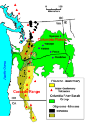
. It is a wide flood basalt
Flood basalt
A flood basalt or trap basalt is the result of a giant volcanic eruption or series of eruptions that coats large stretches of land or the ocean floor with basalt lava. Flood basalts have occurred on continental scales in prehistory, creating great plateaus and mountain ranges...
plateau between the Cascade Range
Cascade Range
The Cascade Range is a major mountain range of western North America, extending from southern British Columbia through Washington and Oregon to Northern California. It includes both non-volcanic mountains, such as the North Cascades, and the notable volcanoes known as the High Cascades...
and the Rocky Mountains
Rocky Mountains
The Rocky Mountains are a major mountain range in western North America. The Rocky Mountains stretch more than from the northernmost part of British Columbia, in western Canada, to New Mexico, in the southwestern United States...
, cut through by the Columbia River
Columbia River
The Columbia River is the largest river in the Pacific Northwest region of North America. The river rises in the Rocky Mountains of British Columbia, Canada, flows northwest and then south into the U.S. state of Washington, then turns west to form most of the border between Washington and the state...
. In one of its various usages, the term "Columbia Basin
Columbia Basin
The Columbia Basin, the drainage basin of the Columbia River, occupies a large area–about —of the Pacific Northwest region of North America. In common usage, the term often refers to a smaller area, generally the portion of the drainage basin that lies within eastern Washington.Usage of the term...
" refers to more or less the same area as the Columbia Plateau.
Geology
During late MioceneMiocene
The Miocene is a geological epoch of the Neogene Period and extends from about . The Miocene was named by Sir Charles Lyell. Its name comes from the Greek words and and means "less recent" because it has 18% fewer modern sea invertebrates than the Pliocene. The Miocene follows the Oligocene...
and early Pliocene
Pliocene
The Pliocene Epoch is the period in the geologic timescale that extends from 5.332 million to 2.588 million years before present. It is the second and youngest epoch of the Neogene Period in the Cenozoic Era. The Pliocene follows the Miocene Epoch and is followed by the Pleistocene Epoch...
times, one of the largest flood basalt
Flood basalt
A flood basalt or trap basalt is the result of a giant volcanic eruption or series of eruptions that coats large stretches of land or the ocean floor with basalt lava. Flood basalts have occurred on continental scales in prehistory, creating great plateaus and mountain ranges...
s ever to appear on the earth
Earth
Earth is the third planet from the Sun, and the densest and fifth-largest of the eight planets in the Solar System. It is also the largest of the Solar System's four terrestrial planets...
's surface engulfed about 63000 square miles (163,169.3 km²) of the Pacific Northwest, forming a large igneous province
Large igneous province
A Large Igneous Province is an extremely large accumulation of igneous rocks—intrusive, extrusive, or both—in the earth's crust...
. Over a period of perhaps 10 to 15 million years lava flow after lava flow poured out, eventually accumulating to a thickness of more than 6,000 feet (1.8 km). As the molten rock came to the surface, the Earth's crust gradually sank into the space left by the rising lava.
The subsidence of the crust produced the large plateau
Plateau
In geology and earth science, a plateau , also called a high plain or tableland, is an area of highland, usually consisting of relatively flat terrain. A highly eroded plateau is called a dissected plateau...
—a large, slightly depressed lava plain sometimes also known as the Columbia Basin
Columbia Basin
The Columbia Basin, the drainage basin of the Columbia River, occupies a large area–about —of the Pacific Northwest region of North America. In common usage, the term often refers to a smaller area, generally the portion of the drainage basin that lies within eastern Washington.Usage of the term...
. The ancient Columbia River
Columbia River
The Columbia River is the largest river in the Pacific Northwest region of North America. The river rises in the Rocky Mountains of British Columbia, Canada, flows northwest and then south into the U.S. state of Washington, then turns west to form most of the border between Washington and the state...
was forced into its present course by the northwesterly advancing lava. The lava, as it flowed over the area, first filled the stream valleys, forming dams that in turn caused impoundments or lakes. Entities that have been found in these lake beds are fossil
Fossil
Fossils are the preserved remains or traces of animals , plants, and other organisms from the remote past...
leaf impressions, petrified wood
Petrified wood
Petrified wood is the name given to a special type of fossilized remains of terrestrial vegetation. It is the result of a tree having turned completely into stone by the process of permineralization...
, fossil insects, and bones of vertebrate animals.
Flora
Part of the Columbia Plateau is associated with the Columbia Plateau ecoregionColumbia Plateau (ecoregion)
The Columbia Plateau ecoregion is a Level III ecoregion designated by the United States Environmental Protection Agency in the U.S. states of Oregon and Washington, with small areas over the Washington state border in Idaho...
, part of the 'Nearctic temperate and subtropical grasslands, savannas, and shrublands' ecoregion
Ecoregion
An ecoregion , sometimes called a bioregion, is an ecologically and geographically defined area that is smaller than an ecozone and larger than an ecosystem. Ecoregions cover relatively large areas of land or water, and contain characteristic, geographically distinct assemblages of natural...
of the Temperate grasslands, savannas, and shrublands
Temperate grasslands, savannas, and shrublands
Temperate grasslands, savannas, and shrublands is a terrestrial biome whose predominant vegetation consists of grasses and/or shrubs. The climate is temperate and semi-arid to semi-humid....
Biome
Biome
Biomes are climatically and geographically defined as similar climatic conditions on the Earth, such as communities of plants, animals, and soil organisms, and are often referred to as ecosystems. Some parts of the earth have more or less the same kind of abiotic and biotic factors spread over a...
.
Geography
The Washington cities in the Columbia Plateau include:- DavenportDavenport, WashingtonDavenport is a city in Lincoln County, Washington, United States. The population was 1,734 at the 2010 census. It is the county seat of Lincoln County.-History:Davenport was first settled in 1880, and was named in 1882 for resident J.C. Davenport...
- KennewickKennewick, WashingtonKennewick is a city in Benton County in the southeastern part of the U.S. state of Washington, near the Hanford nuclear site. It is the most populous of the three cities collectively referred to as the Tri-Cities...
- Moses LakeMoses Lake, WashingtonMoses Lake is a city in Grant County, Washington, United States. The population was 20,366 as of the 2010 census. Moses Lake is the largest city in Grant County.-Background:...
- PascoPasco, WashingtonPasco is a city in and the county seat of Franklin County, Washington, United States.Pasco is one of three cities that make up the Tri-Cities region of the state of Washington...
- PullmanPullman, WashingtonPullman is the largest city in Whitman County, Washington, United States. The population was 24,675 at the 2000 census and 29,799 according to the 2010 census...
- RichlandRichland, WashingtonRichland is a city in Benton County in the southeastern part of the U.S. state of Washington, at the confluence of the Yakima and the Columbia Rivers. As of the 2010 census, the city population was 48,058. April 1, 2011 estimates from the Washington State Office of Financial Management put the...
- SpokaneSpokane, WashingtonSpokane is a city located in the Northwestern United States in the state of Washington. It is the largest city of Spokane County of which it is also the county seat, and the metropolitan center of the Inland Northwest region...
- Walla WallaWalla Walla, WashingtonWalla Walla is the largest city in and the county seat of Walla Walla County, Washington, United States. The population was 31,731 at the 2010 census...
- YakimaYakima, WashingtonYakima is an American city southeast of Mount Rainier National Park and the county seat of Yakima County, Washington, United States, and the eighth largest city by population in the state itself. As of the 2010 census, the city had a total population of 91,196 and a metropolitan population of...
Oregon cities in the Columbia Plateau include:
- HermistonHermiston, OregonAs of the census of 2010, there were 16,745 people, 4,964 households, and 3,360 families residing in the city. The population density was 2,035.4 people per square mile . There were 5,383 housing units at an average density of 832.9 per square mile...
- Hood RiverHood River, OregonThe city of Hood River is the seat of Hood River County, Oregon, United States. It is a port on the Columbia River, and is named for the nearby Hood River. As of the 2000 census, the city population was 5,831...
- PendletonPendleton, OregonPendleton is a city in Umatilla County, Oregon, United States. Pendleton was named in 1868 by the county commissioners for George H. Pendleton, Democratic candidate for Vice-President in the 1864 presidential campaign. The population was 16,612 at the 2010 census...
- The DallesThe Dalles, OregonThe Dalles is the largest city and county seat of Wasco County, Oregon, United States. The name of the city comes from the French word dalle The Dalles is the largest city and county seat of Wasco County, Oregon, United States. The name of the city comes from the French word dalle The Dalles is...