
Spokane River
Encyclopedia
The Spokane River is a tributary of the Columbia River
, approximately 111 miles (178.6 km) long, in northern Idaho
and eastern Washington in the United States
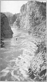
. It drains a low mountainous area east of the Columbia, passing through the city of Spokane, Washington
.
in the Idaho Panhandle
, emptying into the Columbia River
at Lake Roosevelt
, approximately 180 km downstream.
From Lake Coeur d'Alene, the Spokane River traverses the Rathdrum Prairie until reaching Post Falls, Idaho
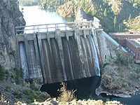
where it passes over a dam
, and a natural 40-foot waterfall. Continuing westward, it later passes over 5 more dams, four of which are located in the city of Spokane. In Spokane, it flows over the Spokane Falls
, which are located in the heart of Downtown Spokane
, approximately one third of the way down the rivers length. About a mile later, the river receives Latah Creek
from the southeast. Soon afterwards, it is met from the northeast by the Little Spokane River
, on the western edge of the city of Spokane. It flows in a zigzag course along the southern edge of the Selkirk Mountains
, forming the southern boundary of the Spokane Indian Reservation, where it is impounded by the Little Falls Dam to form Long Lake, a 15 mi (24 km) reservoir. It joins Franklin D. Roosevelt Lake
on the Columbia from the east at Miles. The site of historic Fort Spokane is located at the mouth of the river on the Columbia.
The Spokane River's entire drainage basin
is about 6240 square miles (16,161.5 km²) large, of which 3840 square miles (9,945.6 km²) are above Post Falls Dam at the outlet of Coeur d'Alene Lake. Its mean annual discharge
is 7946 cuft/s.
Indians (along with other Salish peoples) used to live and travel along the banks of the Spokane River.
Today, the metropolitan area of the city of Spokane, Washington
(population 425,000) is the largest human settlement on the banks of the Spokane River. The metropolitan are of Coeur d'Alene and Post Falls, Idaho (pop. 200,000) are also seated alongside the river. The Spokane River and Lake Coeur d'Alene area the primary sources of recharge for the Spokane aquifer, which is the primary source of drinking water for each of these settlements.
and traveling from the Bunker Hill Mine and Smelting Complex
Superfund Site.
Spokane's sewage treatment
facilities empty their outflow into the Spokane River. In 1889, Spokane built a sewage system that dumped raw sewage directly into the river, which was visibly noticeable by 1920. In 1957 a primary treatment facility was installed; however, this was soon deemed inadequate by the Washington State Department of Ecology. This led to the construction of a more advanced treatment plant that utilized chemical precipitation technology, which was connected in 1975, and operational by 1977.
 After the Northern Pacific Railway
lines arrived in Spokane in 1882, there was rapid growth in milling operations along the river. Many of these mills required dams to provide power for their machinery. As a result of the dams blocking the river, salmon populations in the Spokane plummeted, leading to complaints from many of the people living upstream. After the construction of Long Lake Dam
in 1915 by Washington Water Power blocked upstream passage, the river's salmon populations disappeared completely.
Steelhead were also abundant on the Spokane River, prior to pollution and the construction of the dams. Today, the Spokane River system is one of the two largest unoccupied stretches of steelhead habitat within their former range.
Today, the Spokane River supports populations of rainbow trout
, northern pikeminnow, and Bridgelip Sucker
s (Catostomus columbianus), as well as several non-native species. Many of the remaining fish, however, are not suitable for human consumption due to the chemical pollution in the river, with signs alongside the river warning that the fish are contaminated with PCBs.
Columbia River
The Columbia River is the largest river in the Pacific Northwest region of North America. The river rises in the Rocky Mountains of British Columbia, Canada, flows northwest and then south into the U.S. state of Washington, then turns west to form most of the border between Washington and the state...
, approximately 111 miles (178.6 km) long, in northern Idaho
Idaho
Idaho is a state in the Rocky Mountain area of the United States. The state's largest city and capital is Boise. Residents are called "Idahoans". Idaho was admitted to the Union on July 3, 1890, as the 43rd state....
and eastern Washington in the United States
United States
The United States of America is a federal constitutional republic comprising fifty states and a federal district...
. It drains a low mountainous area east of the Columbia, passing through the city of Spokane, Washington
Spokane, Washington
Spokane is a city located in the Northwestern United States in the state of Washington. It is the largest city of Spokane County of which it is also the county seat, and the metropolitan center of the Inland Northwest region...
.
Description
The Spokane River drains the northern part of Lake Coeur d'AleneLake Coeur d'Alene
Lake Coeur d'Alene is a natural lake in the Idaho Panhandle, located in the vicinity of the city of the same name. It spans long, ranges from 1 to wide and has over of shoreline for boaters and vacationers to explore and enjoy.-Geology and geography:...
in the Idaho Panhandle
Idaho Panhandle
The Idaho Panhandle is the northern region of the U.S. State of Idaho that encompasses the ten northernmost counties of Benewah, Bonner, Boundary, Clearwater, Idaho, Kootenai, Latah, Lewis, Nez Perce, Shoshone. Residents of the panhandle refer to the region as North Idaho...
, emptying into the Columbia River
Columbia River
The Columbia River is the largest river in the Pacific Northwest region of North America. The river rises in the Rocky Mountains of British Columbia, Canada, flows northwest and then south into the U.S. state of Washington, then turns west to form most of the border between Washington and the state...
at Lake Roosevelt
Lake Roosevelt
Lake Roosevelt is the name of multiple places:in the United States:*Theodore Roosevelt Lake on the Salt River in Arizona*Franklin Delano Roosevelt Lake on the Columbia River in Washington...
, approximately 180 km downstream.
From Lake Coeur d'Alene, the Spokane River traverses the Rathdrum Prairie until reaching Post Falls, Idaho
Post Falls, Idaho
Post Falls is a city in Kootenai County, Idaho, United States near the Idaho state line between Spokane, Washington, and Coeur d'Alene, Idaho. The population was 17,247 at the 2000 census, and grew to 27,574 people by the 2010 census, making it Idaho's tenth largest city.-History:Post Falls is...
where it passes over a dam
Dam
A dam is a barrier that impounds water or underground streams. Dams generally serve the primary purpose of retaining water, while other structures such as floodgates or levees are used to manage or prevent water flow into specific land regions. Hydropower and pumped-storage hydroelectricity are...
, and a natural 40-foot waterfall. Continuing westward, it later passes over 5 more dams, four of which are located in the city of Spokane. In Spokane, it flows over the Spokane Falls
Spokane Falls
Spokane Falls is the name of the series of waterfalls and dams on the Spokane River in downtown Spokane, Washington.The Indian name for the Spokane Falls was "Stluputqu", meaning "swift water". The falls was once the site of a large Spokane people village....
, which are located in the heart of Downtown Spokane
Downtown Spokane
Downtown Spokane is the central business district in Spokane, Washington. Downtown Spokane's rough boundaries are I-90 to the south, Division St. to the east, Maple St...
, approximately one third of the way down the rivers length. About a mile later, the river receives Latah Creek
Latah Creek
Latah Creek, also known as Hangman Creek, is a large stream in eastern Washington and north central Idaho in the United States. The creek flows northwest from the Rocky Mountains to Spokane, where it empties into the Spokane River...
from the southeast. Soon afterwards, it is met from the northeast by the Little Spokane River
Little Spokane River
The Little Spokane River is a major tributary of the Spokane River, approximately 35 mi long, in eastern Washington in the United States. It drains a rural area of forested foothills and a farming valley north of the city of Spokane along the Idaho-Washington border.It rises in southern Pend...
, on the western edge of the city of Spokane. It flows in a zigzag course along the southern edge of the Selkirk Mountains
Selkirk Mountains
The Selkirk Mountains are a mountain range spanning the northern portion of the Idaho Panhandle, eastern Washington, and southeastern British Columbia. They begin at Mica Peak near Coeur d'Alene, Idaho and extend approximately 320 km north from the border. The range is bounded on its west,...
, forming the southern boundary of the Spokane Indian Reservation, where it is impounded by the Little Falls Dam to form Long Lake, a 15 mi (24 km) reservoir. It joins Franklin D. Roosevelt Lake
Franklin D. Roosevelt Lake
Franklin D. Roosevelt Lake is the reservoir created in 1941 by the impoundment of the Columbia River by the Grand Coulee Dam in Washington state. It is named for Franklin D. Roosevelt, who was President during the construction of the dam...
on the Columbia from the east at Miles. The site of historic Fort Spokane is located at the mouth of the river on the Columbia.
The Spokane River's entire drainage basin
Drainage basin
A drainage basin is an extent or an area of land where surface water from rain and melting snow or ice converges to a single point, usually the exit of the basin, where the waters join another waterbody, such as a river, lake, reservoir, estuary, wetland, sea, or ocean...
is about 6240 square miles (16,161.5 km²) large, of which 3840 square miles (9,945.6 km²) are above Post Falls Dam at the outlet of Coeur d'Alene Lake. Its mean annual discharge
Discharge (hydrology)
In hydrology, discharge is the volume rate of water flow, including any suspended solids , dissolved chemical species and/or biologic material , which is transported through a given cross-sectional area...
is 7946 cuft/s.
Human use
Until the 18th century, the Coeur d'Alene (Schḭtsu'umsh) and SpokaneSpokane Indians
The Spokane Indians are a minor league baseball team located in Spokane, Washington, United States. They are a Short-Season A classification team in the Northwest League and have been a farm team of the Texas Rangers since 2003. The Indians play home games at Avista Stadium...
Indians (along with other Salish peoples) used to live and travel along the banks of the Spokane River.
Today, the metropolitan area of the city of Spokane, Washington
Spokane, Washington
Spokane is a city located in the Northwestern United States in the state of Washington. It is the largest city of Spokane County of which it is also the county seat, and the metropolitan center of the Inland Northwest region...
(population 425,000) is the largest human settlement on the banks of the Spokane River. The metropolitan are of Coeur d'Alene and Post Falls, Idaho (pop. 200,000) are also seated alongside the river. The Spokane River and Lake Coeur d'Alene area the primary sources of recharge for the Spokane aquifer, which is the primary source of drinking water for each of these settlements.
Pollution
The Spokane River contains some of the highest concentrations of heavy metals of any river in the state, resulting from pollution coming from Lake Coeur D'AleneLake Coeur d'Alene
Lake Coeur d'Alene is a natural lake in the Idaho Panhandle, located in the vicinity of the city of the same name. It spans long, ranges from 1 to wide and has over of shoreline for boaters and vacationers to explore and enjoy.-Geology and geography:...
and traveling from the Bunker Hill Mine and Smelting Complex
Bunker Hill Mine and Smelting Complex
The Bunker Hill Mine and Smelting Complex , was a large smelter located in Kellogg, Idaho. When built, it was the largest smelting facility in the world....
Superfund Site.
Spokane's sewage treatment
Sewage treatment
Sewage treatment, or domestic wastewater treatment, is the process of removing contaminants from wastewater and household sewage, both runoff and domestic. It includes physical, chemical, and biological processes to remove physical, chemical and biological contaminants...
facilities empty their outflow into the Spokane River. In 1889, Spokane built a sewage system that dumped raw sewage directly into the river, which was visibly noticeable by 1920. In 1957 a primary treatment facility was installed; however, this was soon deemed inadequate by the Washington State Department of Ecology. This led to the construction of a more advanced treatment plant that utilized chemical precipitation technology, which was connected in 1975, and operational by 1977.
Fish habitat
Northern Pacific Railway
The Northern Pacific Railway was a railway that operated in the west along the Canadian border of the United States. Construction began in 1870 and the main line opened all the way from the Great Lakes to the Pacific when former president Ulysses S. Grant drove in the final "golden spike" in...
lines arrived in Spokane in 1882, there was rapid growth in milling operations along the river. Many of these mills required dams to provide power for their machinery. As a result of the dams blocking the river, salmon populations in the Spokane plummeted, leading to complaints from many of the people living upstream. After the construction of Long Lake Dam
Long Lake Dam
Long Lake Dam is a concrete gravity dam on the Spokane River, about northwest of Spokane in eastern Washington. It forms Long Lake, a long reservoir, and has a hydroelectric generating capacity of 71 megawatts...
in 1915 by Washington Water Power blocked upstream passage, the river's salmon populations disappeared completely.
Steelhead were also abundant on the Spokane River, prior to pollution and the construction of the dams. Today, the Spokane River system is one of the two largest unoccupied stretches of steelhead habitat within their former range.
Today, the Spokane River supports populations of rainbow trout
Rainbow trout
The rainbow trout is a species of salmonid native to tributaries of the Pacific Ocean in Asia and North America. The steelhead is a sea run rainbow trout usually returning to freshwater to spawn after 2 to 3 years at sea. In other words, rainbow trout and steelhead trout are the same species....
, northern pikeminnow, and Bridgelip Sucker
Bridgelip Sucker
Bridgelip Sucker is a fish in the family Catostomidae....
s (Catostomus columbianus), as well as several non-native species. Many of the remaining fish, however, are not suitable for human consumption due to the chemical pollution in the river, with signs alongside the river warning that the fish are contaminated with PCBs.
See also
- Bunker Hill Mine and Smelting ComplexBunker Hill Mine and Smelting ComplexThe Bunker Hill Mine and Smelting Complex , was a large smelter located in Kellogg, Idaho. When built, it was the largest smelting facility in the world....
- List of Idaho rivers
- List of Washington rivers
- Spokane River Centennial TrailSpokane River Centennial TrailThe Spokane River Centennial Trail is a paved trail in Washington for alternate transportation and recreational use. It extends from Sontag Park in Nine Mile Falls, Washington to the Washington/Idaho border. It passes through the cities of Spokane, Washington, Spokane Valley, Washington, Liberty...
- North Idaho Centennial TrailNorth Idaho Centennial TrailThe North Idaho Centennial Trail is a paved trail in Idaho used for transportation and recreational activities. Extending from Higgens Point on the northeast side of Lake Coeur d'Alene, a popular place for bald eagle watchers in early winter, the trail follows the lake's north shoreline to the...
- Harker CanyonHarker Canyon (Washington)Harker Canyon is formed by a tributary of the Spokane River, where it forms the Spokane Arm of Franklin D. Roosevelt Lake, in Lincoln County, Washington, United States. A small portion of the canyon where it empties into the Spokane River is part of the Lake Roosevelt National Recreation Area. ...