
Humboldt River
Encyclopedia
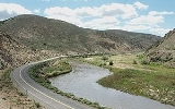
The Humboldt River runs through northern Nevada
in the western United States
. At approximately 330 miles (531.1 km) long it is the second longest river in the Great Basin
, after the Bear River
. It has no outlet to the ocean, but instead empties into the Humboldt Sink
. It is the fourth largest river in the United States, in terms of discharge, that does not ultimately reach the ocean, while it is the largest in terms of area drained. Through its tributaries the river drains most of sparsely populated northern Nevada, traversing the state roughly east to west, and passing through repeated gaps in the north-south running mountain ranges. It furnishes the only natural transportation artery across the Great Basin, and has provided a route for the historical route
for westward migration, railroads, and modern highways
. The river is named for the German
naturalist Alexander von Humboldt
.
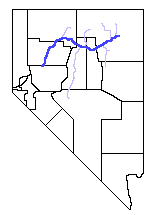
, just outside the city of Wells
. The river flows west-southwest through Elko County
past the community of Elko
. In northern Eureka County
it passes along the south end of the Tuscarora Mountains
, and then along the north end of the Shoshone Range
. At Battle Mountain
it turns northwest for approximately 50 miles (80.5 km), then west at Red House and past Golconda
and a spur of the Sonoma Range
. Then it turns southwest, flowing past Winnemucca
and through Pershing County
, along the western side of the Humboldt Range
and the West Humboldt Range
. It empties into an intermittent lake
in the Humboldt Sink
on the border between Pershing
and Churchill
counties, approximately 20 miles (32.2 km) southwest of Lovelock
.
 The river receives the North Fork
of the Humboldt River in Elko County, approximately 15 miles (24.1 km) upstream from Elko, and the South Fork
approximately 7 miles (11.3 km) downstream. It merges with the Reese River
near Battle Mountain, and receives the Little Humboldt River
approximately 5 miles (8 km) upstream from Winnemucca. It is impounded in central Pershing County by the Rye Patch Dam, forming the Rye Patch Reservoir.
The river is highly variable in flow, generally decreasing in volume downstream to the west, in part due to the removal of water from the river for irrigation.
and Shoshone
at the time of the arrival of Europe
an American
settlers. The region was little known by non-indigenous peoples until the arrival of fur trappers
in the middle 19th century.
The first recorded sighting of the river was on November 9, 1828, by Peter Skene Ogden
of the Hudson's Bay Company
, during his fifth expedition to the Snake Country
. Odgen came southward along the Little Humboldt, encountering the main river at the confluence near Winnemucca. Ogden explored the river for several hundred miles, blazing a trail along it and making the first known map of the region. He initially named the river "Unknown River", due to the source and course of the river still being unknown to him, and later "Paul's River", after one of his trappers who died on the expedition and was buried on the river bank. He later changed it again to "Mary's River," named after the Native American
wife of one of his trappers, which later somehow became "St. Mary's River". However in 1829 he suggested that "Swampy River" best described the course he had traversed. In 1833 the Bonneville-Walker fur party
explored the river, naming it "Barren River". Washington Irving
's 1837 book describing the Bonneville expedition called it "Ogden's River", the name used by many early travelers. By the early 1840s the trail along the river was being used by settlers going west to California
.
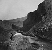
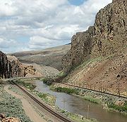
In 1848 the river was explored by John C. Frémont
, who made a thorough map of the region and gave the river its current name. The following year the river became the route of the California Trail
, the primary land route for migrants to the California gold fields
. In 1869 the river was used as part of the route of the Central Pacific
segment of the Transcontinental Railroad.
In the 20th Century, the valley of the river became the route for U.S. Highway 40, later replaced by Interstate 80. In the latter part of the 20th Century, about 45,000 people lived within 10 miles (16.1 km) of the river, roughly a third of the population at that time of the State of Nevada outside of Western Nevada
and Southern Nevada
, before the rapid 21st Century growth of Southern Nevada changed these population figures.
Nevada
Nevada is a state in the western, mountain west, and southwestern regions of the United States. With an area of and a population of about 2.7 million, it is the 7th-largest and 35th-most populous state. Over two-thirds of Nevada's people live in the Las Vegas metropolitan area, which contains its...
in the western United States
Western United States
.The Western United States, commonly referred to as the American West or simply "the West," traditionally refers to the region comprising the westernmost states of the United States. Because the U.S. expanded westward after its founding, the meaning of the West has evolved over time...
. At approximately 330 miles (531.1 km) long it is the second longest river in the Great Basin
Great Basin
The Great Basin is the largest area of contiguous endorheic watersheds in North America and is noted for its arid conditions and Basin and Range topography that varies from the North American low point at Badwater Basin to the highest point of the contiguous United States, less than away at the...
, after the Bear River
Bear River (Utah)
The Bear River is a river, approximately long, in southwestern Wyoming, southeastern Idaho, and northern Utah, in the United States. The largest tributary of the Great Salt Lake, it drains a mountainous area and farming valleys northeast of the lake and southeast of the Snake River Plain...
. It has no outlet to the ocean, but instead empties into the Humboldt Sink
Humboldt Sink
Humboldt Sink is an intermittent dry lake bed, approximately 11 mi long, and 4 mi across, in northwestern Nevada in the United States...
. It is the fourth largest river in the United States, in terms of discharge, that does not ultimately reach the ocean, while it is the largest in terms of area drained. Through its tributaries the river drains most of sparsely populated northern Nevada, traversing the state roughly east to west, and passing through repeated gaps in the north-south running mountain ranges. It furnishes the only natural transportation artery across the Great Basin, and has provided a route for the historical route
California Trail
The California Trail was an emigrant trail of about across the western half of the North American continent from Missouri River towns to what is now the state of California...
for westward migration, railroads, and modern highways
Interstate 80
Interstate 80 is the second-longest Interstate Highway in the United States, following Interstate 90. It is a transcontinental artery running from downtown San Francisco, California to Teaneck, New Jersey in the New York City Metropolitan Area...
. The river is named for the German
Germany
Germany , officially the Federal Republic of Germany , is a federal parliamentary republic in Europe. The country consists of 16 states while the capital and largest city is Berlin. Germany covers an area of 357,021 km2 and has a largely temperate seasonal climate...
naturalist Alexander von Humboldt
Alexander von Humboldt
Friedrich Wilhelm Heinrich Alexander Freiherr von Humboldt was a German naturalist and explorer, and the younger brother of the Prussian minister, philosopher and linguist Wilhelm von Humboldt...
.
Course
The source of the river is a spring called Humboldt Wells at the northern tip of the East Humboldt RangeEast Humboldt Range
The East Humboldt Range is a line of mountains in northeastern Nevada in the Great Basin region of the western United States. It located in central Elko County in the upper watershed of the Humboldt River, which flows to the southwest from its source just north of the range.The East Humboldts run...
, just outside the city of Wells
Wells, Nevada
Wells is a city in Elko County, in northeast Nevada in the western United States. The population was 1,346 at the 2000 census. Wells is located at the junction of U.S. Route 93 and Interstate 80, approximately east of Elko and is part of the Elko Micropolitan Statistical Area.-History:The site...
. The river flows west-southwest through Elko County
Elko County, Nevada
-Demographics:As of the census of 2000, there were 45,291 people, 15,638 households, and 11,493 families residing in the county. The population density was 3/sq mi . There were 18,456 housing units at an average density of 1/sq mi...
past the community of Elko
Elko, Nevada
Elko is a city in Elko County, Nevada, United States. The population was 18,297 at the 2010 census. It is the county seat of Elko County. The city straddles the Humboldt River....
. In northern Eureka County
Eureka County, Nevada
Eureka County is a county located in the U.S. state of Nevada. As of the 2000 census, the population was 1,651. Its county seat is Eureka.Eureka County is part of the Elko Micropolitan Statistical Area.-History:...
it passes along the south end of the Tuscarora Mountains
Tuscarora Mountains
The Tuscarora Mountains are a mountain range in Elko County, Nevada. The southern perimeter of the north-south mountain range is the Humboldt River and valley....
, and then along the north end of the Shoshone Range
Shoshone Range
in Nye County.The Shoshone Range is a mountain range in Lander County, Nevada.The Humboldt River and valley are on the northern perimeter of the range....
. At Battle Mountain
Battle Mountain, Nevada
Battle Mountain is an unincorporated community and census-designated place in Lander County, Nevada, United States. The population was 2,871 at the 2000 census. Though it has no legal status as a municipality, it still functions as the county seat of Lander County...
it turns northwest for approximately 50 miles (80.5 km), then west at Red House and past Golconda
Golconda, Nevada
Golconda is an unincorporated community in Humboldt County, Nevada, United States. Located along Interstate 80 in the northwestern part of the state, it is named for the ancient diamond mining center of Golkonda in India. The community lies east of the city of Winnemucca and the Golconda Summit,...
and a spur of the Sonoma Range
Sonoma Range
The Sonoma Range is a small mountain range in northwest Nevada, USA, lying just south of the Humboldt River between Winnemucca and Golconda. It is one of the many ranges of the basin and range geologic province of the Great Basin. Sonoma Peak is the highest mountain in the range at...
. Then it turns southwest, flowing past Winnemucca
Winnemucca, Nevada
-Demographics:As of the census of 2000, there were 7,174 people, 2,736 households, and 1,824 families residing in the city. The population density was 867.5 people per square mile . There were 3,280 housing units at an average density of 396.6 per square mile...
and through Pershing County
Pershing County, Nevada
Pershing County is a county located in the U.S. state of Nevada. As of the 2000 census, the population was 6,693. Its county seat is Lovelock. The county was named after army general John J. Pershing . It was formed from Humboldt County in 1919, and the last county to be established in...
, along the western side of the Humboldt Range
Humboldt Range
The Humboldt Range is a largely north-south running range of mountains in northwest Nevada, USA, that extend from the town of Imlay in the north to the junction with the West Humboldt Range in the south...
and the West Humboldt Range
West Humboldt Range
The West Humboldt Range is a short mountain range in the western Great Basin in northwestern Nevada in the United States. It runs for approximately 40 mi southwest to northeast in northern Churchill County and southern Pershing County...
. It empties into an intermittent lake
Lake Humboldt
Lake Humboldt or Humboldt Lake is a lake in northern Churchill County and southern Pershing County in the state of Nevada in the United States....
in the Humboldt Sink
Humboldt Sink
Humboldt Sink is an intermittent dry lake bed, approximately 11 mi long, and 4 mi across, in northwestern Nevada in the United States...
on the border between Pershing
Pershing County, Nevada
Pershing County is a county located in the U.S. state of Nevada. As of the 2000 census, the population was 6,693. Its county seat is Lovelock. The county was named after army general John J. Pershing . It was formed from Humboldt County in 1919, and the last county to be established in...
and Churchill
Churchill County, Nevada
Churchill County is a county located in the western U.S. state of Nevada. As of the 2000 census, the population was 23,982. As of July 1, 2007, the population of Churchill County was estimated at 27,190. The county, named after Mexican-American War hero brevet Brigadier General Sylvester Churchill,...
counties, approximately 20 miles (32.2 km) southwest of Lovelock
Lovelock, Nevada
Lovelock is a city in western Nevada that is the county seat of Pershing County, the location of a prison, and the namesake of the area's Cold War gunnery range...
.
North Fork Humboldt River
The North Fork of the Humboldt River has its origins on the north slopes of McAfee Peak in the Independence Mountains of northeastern Nevada. It quickly exits the mountains and turns southward for approximately , joining its waters with numerous other streams...
of the Humboldt River in Elko County, approximately 15 miles (24.1 km) upstream from Elko, and the South Fork
South Fork Humboldt River
The South Fork of the Humboldt River has its origins in a fan-shaped group of canyons draining the western slopes of the Ruby Mountains in northeastern Nevada. These headwaters run from Ruby Dome south to King Peak, and include Echo, Box, Kleckner, North Furlong, Long, Segunda, Drown, and...
approximately 7 miles (11.3 km) downstream. It merges with the Reese River
Reese River
The Reese River is a tributary of the Humboldt River, located in central Nevada in the western United States. It rises in the southern section of the Toiyabe Range, on the flanks of Arc Dome...
near Battle Mountain, and receives the Little Humboldt River
Little Humboldt River
The Little Humboldt River is a tributary of the Humboldt River, approximately long, in northern Nevada in the western United States. It is an intermittent stream draining a rugged area on the edge of the Owyhee Desert in the Great Basin....
approximately 5 miles (8 km) upstream from Winnemucca. It is impounded in central Pershing County by the Rye Patch Dam, forming the Rye Patch Reservoir.
The river is highly variable in flow, generally decreasing in volume downstream to the west, in part due to the removal of water from the river for irrigation.
History
The region of the river in northern Nevada was sparsely inhabited by the PaiutePaiute
Paiute refers to three closely related groups of Native Americans — the Northern Paiute of California, Idaho, Nevada and Oregon; the Owens Valley Paiute of California and Nevada; and the Southern Paiute of Arizona, southeastern California and Nevada, and Utah.-Origin of name:The origin of...
and Shoshone
Shoshone
The Shoshone or Shoshoni are a Native American tribe in the United States with three large divisions: the Northern, the Western and the Eastern....
at the time of the arrival of Europe
Europe
Europe is, by convention, one of the world's seven continents. Comprising the westernmost peninsula of Eurasia, Europe is generally 'divided' from Asia to its east by the watershed divides of the Ural and Caucasus Mountains, the Ural River, the Caspian and Black Seas, and the waterways connecting...
an American
United States
The United States of America is a federal constitutional republic comprising fifty states and a federal district...
settlers. The region was little known by non-indigenous peoples until the arrival of fur trappers
Fur trade
The fur trade is a worldwide industry dealing in the acquisition and sale of animal fur. Since the establishment of world market for in the early modern period furs of boreal, polar and cold temperate mammalian animals have been the most valued...
in the middle 19th century.
The first recorded sighting of the river was on November 9, 1828, by Peter Skene Ogden
Peter Skene Ogden
Peter Skene Ogden , was a fur trader and a Canadian explorer of what is now British Columbia and the American West...
of the Hudson's Bay Company
Hudson's Bay Company
The Hudson's Bay Company , abbreviated HBC, or "The Bay" is the oldest commercial corporation in North America and one of the oldest in the world. A fur trading business for much of its existence, today Hudson's Bay Company owns and operates retail stores throughout Canada...
, during his fifth expedition to the Snake Country
Snake River
The Snake is a major river of the greater Pacific Northwest in the United States. At long, it is the largest tributary of the Columbia River, the largest North American river that empties into the Pacific Ocean...
. Odgen came southward along the Little Humboldt, encountering the main river at the confluence near Winnemucca. Ogden explored the river for several hundred miles, blazing a trail along it and making the first known map of the region. He initially named the river "Unknown River", due to the source and course of the river still being unknown to him, and later "Paul's River", after one of his trappers who died on the expedition and was buried on the river bank. He later changed it again to "Mary's River," named after the Native American
Native Americans in the United States
Native Americans in the United States are the indigenous peoples in North America within the boundaries of the present-day continental United States, parts of Alaska, and the island state of Hawaii. They are composed of numerous, distinct tribes, states, and ethnic groups, many of which survive as...
wife of one of his trappers, which later somehow became "St. Mary's River". However in 1829 he suggested that "Swampy River" best described the course he had traversed. In 1833 the Bonneville-Walker fur party
Benjamin Bonneville
Benjamin Louis Eulalie de Bonneville was a French-born officer in the United States Army, fur trapper, and explorer in the American West...
explored the river, naming it "Barren River". Washington Irving
Washington Irving
Washington Irving was an American author, essayist, biographer and historian of the early 19th century. He was best known for his short stories "The Legend of Sleepy Hollow" and "Rip Van Winkle", both of which appear in his book The Sketch Book of Geoffrey Crayon, Gent. His historical works...
's 1837 book describing the Bonneville expedition called it "Ogden's River", the name used by many early travelers. By the early 1840s the trail along the river was being used by settlers going west to California
California
California is a state located on the West Coast of the United States. It is by far the most populous U.S. state, and the third-largest by land area...
.
In 1848 the river was explored by John C. Frémont
John C. Frémont
John Charles Frémont , was an American military officer, explorer, and the first candidate of the anti-slavery Republican Party for the office of President of the United States. During the 1840s, that era's penny press accorded Frémont the sobriquet The Pathfinder...
, who made a thorough map of the region and gave the river its current name. The following year the river became the route of the California Trail
California Trail
The California Trail was an emigrant trail of about across the western half of the North American continent from Missouri River towns to what is now the state of California...
, the primary land route for migrants to the California gold fields
California Gold Rush
The California Gold Rush began on January 24, 1848, when gold was found by James W. Marshall at Sutter's Mill in Coloma, California. The first to hear confirmed information of the gold rush were the people in Oregon, the Sandwich Islands , and Latin America, who were the first to start flocking to...
. In 1869 the river was used as part of the route of the Central Pacific
Central Pacific Railroad
The Central Pacific Railroad is the former name of the railroad network built between California and Utah, USA that formed part of the "First Transcontinental Railroad" in North America. It is now part of the Union Pacific Railroad. Many 19th century national proposals to build a transcontinental...
segment of the Transcontinental Railroad.
In the 20th Century, the valley of the river became the route for U.S. Highway 40, later replaced by Interstate 80. In the latter part of the 20th Century, about 45,000 people lived within 10 miles (16.1 km) of the river, roughly a third of the population at that time of the State of Nevada outside of Western Nevada
Western Nevada
Western Nevada is a region that includes Reno, Carson City and the Carson Valley. Lyon County and Churchill County are sometimes also referred to as part of Western Nevada....
and Southern Nevada
Southern Nevada
Southern Nevada is the region of Nevada which includes the Las Vegas Valley. Southern Nevada also includes the areas in and around Goldfield, Hawthorne, Pahrump, and Pioche. Geographically, Southern Nevada is partly, and in some cases, fully within the Mojave Desert. The population of the...
, before the rapid 21st Century growth of Southern Nevada changed these population figures.
Further reading
- Wallace, A.R. et al. (2005). Metallic mineral resource assessment of the Humboldt River Basin, northern Nevada (USGS Fact Sheet 2005-3023]. Reno, NV: U.S. Department of the Interior, U.S. Geological Survey.
- Yager, D.B. and H.W. Folger. (2003). Map showing silver concentrations from stream sediments and soils throughout the Humboldt River Basin and surrounding areas, northern Nevada [U.S. Geological Survey Miscellaneous Field Studies Map MF-2407-I]. Denver, CO: U.S. Department of the Interior, U.S. Geological Survey.