
Payette River
Encyclopedia
The Payette River is an 82.7 miles (133.1 km) river in southwestern Idaho
and is a major tributary
of the Snake River
.
Its headwaters originate in the Sawtooth
and Salmon River Mountains
at elevations over 10000 feet (3,048 m). Drainage in the watershed flows primarily from east to west, with the cumulative stream length to the head of the North Fork Payette River being 180 miles (289.7 km), while to the head of the South Fork the cumulative length is nearly 163 miles (262.3 km). The combined Payette River flows into an agricultural valley and empties into the Snake River near the city of Payette
at an elevation of 2125 feet (647.7 m). The Payette River's drainage basin
comprises about 3240 square miles (8,391.6 km²). It is a physiographic section of the Columbia Plateau
province, which in turn is part of the larger Intermontane Plateaus
physiographic division. The South Fork of the Payette has its headwaters in the Sawtooth Wilderness
, which is part of the Sawtooth National Recreation Area
.
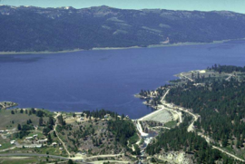
and flowing into Payette Lake. The North Fork exits at the southwest end of Payette Lake at 4990 feet (1,521 m) and flows south in the "Long Valley" of Valley County
toward Cascade
. It then flows into the Cascade Reservoir
, then continues south, accompanied by Highway 55
.
The South Fork Payette River drains about 1200 square miles (3,108 km²), originating on the west side of the Sawtooth Wilderness
beneath the 10211 feet (3,112.3 m) Mount Payette. It flows past Grandjean and down to Lowman
, along Highway 21. The shorter Middle Fork Payette River parallels the lower North Fork 10 miles (16.1 km) to the east, flowing south and joining the South Fork just southwest of Crouch. Further east, the Deadwood River parallels the Middle Fork and empties into the South Fork just west of Lowman
. The main stem
of the Payette River is shown on USGS topographic maps as beginning at the confluence
of the South and Middle forks.
The North Fork joins the Payette at the village of Banks, at an elevation of 2790 feet (850.4 m). The main stem flows south from Banks for 15 miles (24.1 km) to Horseshoe Bend
, then west into Black Canyon Reservoir. Below the reservoir's dam, the river flows past Emmett
and Payette
, then empties into the Snake River
at the Oregon border. The Payette River has an average annual discharge into the Snake River of 2192000 acre.ft of water.
 The river's watershed was originally settled by the Shoshone
, Nez Perce, Paiute
and Bannock
Native American tribes. Before white contact, many of these indigenous peoples had no permanent villages or settlements. For hundreds of years, in the fall and winter, they would camp in the arid grasslands along the main stem of the Payette River, while in spring and summer, they temporarily moved to the lusher upper basin of the North Fork to hunt and fish in preparation for the coming winter. Camas
bulbs, coming from a widespread flowering plant
in the basin, was their primary staple throughout the year. In order to maintain the naturally occurring fields of camas, they would set controlled fires whenever they left their camps for the biyearly move through the river basin. The seasonal burning came with added benefits, including clearing unwanted vegetation and protecting their campsites from overgrowth.
In the 19th century, white settlers began moving into western Idaho and established trading posts, towns and farms in the area. One of these early pioneers was Francois Payette
, for whom the river is named. A French-Canadian fur trapper who worked for the North West Company
, he was one of the first people of European descent to settle in the Payette River area. Payette ventured east from Fort Astoria
in 1818. From 1835 to 1844, he headed the Hudson's Bay Company
's Fort Boise
trading post near Parma
, on the Snake River some distance south of the Payette River. In 1844, Payette retired to Montreal
, still over twenty years before emigrants began to arrive in great numbers. One of the first settlements was on Clear Creek, a tributary of the South Fork Payette River. Many of the Native Americans were unhappy with the new settlers and the great numbers of pioneers traveling through the area bound for the West Coast for causing damage to their lands, leading to the Nez Perce War
of 1877 and many small conflicts with miners, ranchers, farmers, homesteaders, and soldiers.
Logging
in the basin began soon after the arrival of settlers, but did not reach large scale until the early 20th century. Demand for wooden railroad tie
s for the Oregon Short Line (OSL) in the 1880s helped to kick off the logging industry in the area. From then on, heavy logging commenced along the North Fork Payette River in Long Valley, downriver of present-day Cascade Lake. A splash dam
was built in 1902 by the Minnesota
-based Payette Lumber and Manufacturing Company on the North Fork in order to better facilitate the transportation of logs downstream. Logging helped to spur even more people to move into the area, and in 1911, the Idaho Northern Railroad
was constructed by the OSL, running from Emmett
near the mouth of the Payette along the river, past present-day Black Canyon Reservoir, up into the North Fork watershed and ending just below Long Valley at Smith's Ferry on the river, named for a settler who bought the operation in 1891. The ferry's primary purpose was to transport livestock and agricultural products between Long Valley and the Snake River.
Agriculture, however, became the primary mainstay in the lower valley of the Payette River. Following from 1874, irrigated
farmland surrounded much of the main stem of the Payette River. The Last Chance Canal and Nobel Canal were among the first irrigation ditches constructed, but did not provide a firm yield because of the lack of water regulation. Black Canyon Dam was constructed on the Payette in 1924 not as a storage facility, but to divert water into the Emmett and Black Canyon Canals, which vastly increased the irrigated acreage in the valley. Deadwood Dam on the Deadwood River, a tributary of the South Fork Payette River, was built in 1929 to provide some degree of flow regulation, though much more effective was the Cascade Dam, constructed on the North Fork in 1948 to form Cascade Lake.
 Due to the wide range in elevation, the Payette River has a variety of fish and fish habitats. Salmon
and steelhead were eliminated in the drainage by Black Canyon Dam, which was first completed in 1924. From its mouth upstream to Black Canyon Dam, the river supports a mixed fishery for coldwater and warmwater species. Mountain whitefish
make up the bulk of game fish in this section of river, with smallmouth bass
, largemouth bass
, channel catfish
, black crappie, rainbow trout
, and brown trout
making significant contributions. Upstream from Black Canyon Dam, the gradient of the river increases with coldwater species increasing in abundance. The South Fork of the Payette River supports excellent populations of wild rainbow trout
. The North Fork of the Payette River has been severely altered by railroad and highway construction and provides only a marginal fishery for salmonids. However, in unaltered sections such as the Cabarton reach, the North Fork is very productive for salmonids.
There are five major impoundments in the Payette basin: Black Canyon, Sage Hen, Paddock, Cascade
, and Deadwood reservoirs. There are also several small impoundments and natural lakes with increased storage, such as the three Payette Lakes. Black Canyon, on the mainstem, provides only marginal fish habitat. Sand from upstream land disturbances has covered most of the habitat. Paddock Reservoir, on Big Willow Creek, has one of the better populations of black crappie in the state and a good fishery for largemouth bass
. Cascade Reservoir on the North Fork is one of the most heavily fished waters in the state. Cascade has an abundance of yellow perch
, coho salmon
, and rainbow trout
. Deadwood Reservoir, completed in 1931, contains kokanee
and cutthroat trout
.
Alpine lakes within the Payette River drainage are stocked with rainbow trout
, cutthroat trout
, cutbow
(rainbow-cutthroat hybrids), golden trout
, and arctic grayling
. Brook trout
are also present in a number of lakes.
. Experts call the North Fork Class V run one of the most challenging river reaches in North America, if not the world. Kayaking
on the lower North Fork from Smith's Ferry to Banks is world-class, easily viewed from state highway #55, which closely hugs its bank, primarily on the west side. The lower North Fork narrows and drops 1700 feet (518 m) in the 16 miles (26 km) above Banks, providing nearly endless Class V rapids (see International Scale of River Difficulty
). The average gradient is 110 feet (33.5 m) per mile (21 m/km) with a maximum gradient of 200 ft/mile (38 m/km). The North Fork's flow rate is controlled through the Cascade Dam, completed in 1948, providing relatively warm water from the shallow Cascade Reservoir
.
To the east of Banks, the South Fork's Canyon, west of Lowman
, is a challenging Class IV run for rafting
. Along this trip is a 40 feet (12.2 m) Class VI waterfall (Big Falls), which is portaged. The North Fork and South Fork merge at Banks to form the Payette River (main), providing a float trip with numerous Class III rapids. The highway
on this lower stretch of the river is on the east bank and a scenic railroad, the Thunder Mountain Line, runs above the west side.
Idaho
Idaho is a state in the Rocky Mountain area of the United States. The state's largest city and capital is Boise. Residents are called "Idahoans". Idaho was admitted to the Union on July 3, 1890, as the 43rd state....
and is a major tributary
Tributary
A tributary or affluent is a stream or river that flows into a main stem river or a lake. A tributary does not flow directly into a sea or ocean...
of the Snake River
Snake River
The Snake is a major river of the greater Pacific Northwest in the United States. At long, it is the largest tributary of the Columbia River, the largest North American river that empties into the Pacific Ocean...
.
Its headwaters originate in the Sawtooth
Sawtooth Range (Idaho)
The Sawtooth Range is part of the Rocky Mountains, located within a few miles south of Stanley, Idaho, in the Western United States. Much of mountain range is within the Sawtooth Wilderness, part of the Sawtooth National Recreation Area...
and Salmon River Mountains
Salmon River Mountains
The Salmon River Mountains are a major mountain range covering most of the central part of the U.S. state of Idaho. The range is over long and its boundaries are usually defined by the Salmon River and its large tributary forks. Part of the central Rocky Mountains, the entire range lies west of...
at elevations over 10000 feet (3,048 m). Drainage in the watershed flows primarily from east to west, with the cumulative stream length to the head of the North Fork Payette River being 180 miles (289.7 km), while to the head of the South Fork the cumulative length is nearly 163 miles (262.3 km). The combined Payette River flows into an agricultural valley and empties into the Snake River near the city of Payette
Payette, Idaho
Payette is a city in and the county seat of Payette County, Idaho, United States. The population was 7,054 at the 2000 census. It is part of the Ontario, OR–ID Micropolitan Statistical Area....
at an elevation of 2125 feet (647.7 m). The Payette River's drainage basin
Drainage basin
A drainage basin is an extent or an area of land where surface water from rain and melting snow or ice converges to a single point, usually the exit of the basin, where the waters join another waterbody, such as a river, lake, reservoir, estuary, wetland, sea, or ocean...
comprises about 3240 square miles (8,391.6 km²). It is a physiographic section of the Columbia Plateau
Columbia River Plateau
The Columbia Plateau is a geologic and geographic region that lies across parts of the U.S. states of Washington, Oregon, and Idaho. It is a wide flood basalt plateau between the Cascade Range and the Rocky Mountains, cut through by the Columbia River...
province, which in turn is part of the larger Intermontane Plateaus
Intermontane Plateaus
Physiographic regions of the U.S. InteriorSee:legendIn some places,high plateaus lie between the mountain ranges, for example,the plateau of Anatolia in Turkey and the plateau of Tibet.These are called "Intermontane plateaus"....
physiographic division. The South Fork of the Payette has its headwaters in the Sawtooth Wilderness
Sawtooth Wilderness
The Sawtooth Wilderness is located in the U.S. state of Idaho. Managed by the U.S. Forest Service in the Sawtooth National Recreation Area. The Wilderness was upgraded in 1972 from "primitive area" status, affording greater protections of the habitat...
, which is part of the Sawtooth National Recreation Area
Sawtooth National Recreation Area
The Sawtooth National Recreation Area is a National Recreation Area located in central Idaho, within the Boise, Challis, and Sawtooth National Forests. The recreation area is managed by the U.S. Forest Service and includes the Sawtooth Wilderness...
.
Geography
The principal tributaries of the Payette River are the North and South forks. The North Fork drains about 950 square miles (2,460.5 km²), beginning north of McCallMcCall, Idaho
McCall is a resort town on the western edge of Valley County, Idaho, United States. Named after its founder, Tom McCall, it is situated on the southern shore of Payette Lake, near the center of the Payette National Forest...
and flowing into Payette Lake. The North Fork exits at the southwest end of Payette Lake at 4990 feet (1,521 m) and flows south in the "Long Valley" of Valley County
Valley County, Idaho
Valley County is a rural county located in west central Idaho in the United States. Established in 1917, it was named after the Long Valley of the North Fork of the Payette River, which extends over 30 miles from Payette Lake at McCall south to Cascade to Round Valley.The valley was formerly a...
toward Cascade
Cascade, Idaho
Cascade is a rural city in and the county seat of Valley County, Idaho, United States, in the west central part of the state. It sits at an elevation of , along the North Fork of the Payette River...
. It then flows into the Cascade Reservoir
Lake Cascade
Lake Cascade is located on the North Fork of the Payette River in Valley County, Idaho, USA, in the Boise National Forest. It is the fourth largest lake or reservoir in the state...
, then continues south, accompanied by Highway 55
Idaho State Highway 55
State Highway 55 is an Idaho highway from Marsing to New Meadows, connecting with US-95 at both ends.From Marsing it travels east to Nampa, Meridian, and Eagle, then north to Horseshoe Bend. SH-55 then climbs the Payette River to Banks, then its north fork to the Long Valley, through the towns of...
.
The South Fork Payette River drains about 1200 square miles (3,108 km²), originating on the west side of the Sawtooth Wilderness
Sawtooth Wilderness
The Sawtooth Wilderness is located in the U.S. state of Idaho. Managed by the U.S. Forest Service in the Sawtooth National Recreation Area. The Wilderness was upgraded in 1972 from "primitive area" status, affording greater protections of the habitat...
beneath the 10211 feet (3,112.3 m) Mount Payette. It flows past Grandjean and down to Lowman
Lowman, Idaho
Lowman is a small unincorporated rural census-designated place in Boise County, Idaho, United States, nestled along the banks of the South Fork of the Payette River in the central part of the state...
, along Highway 21. The shorter Middle Fork Payette River parallels the lower North Fork 10 miles (16.1 km) to the east, flowing south and joining the South Fork just southwest of Crouch. Further east, the Deadwood River parallels the Middle Fork and empties into the South Fork just west of Lowman
Lowman, Idaho
Lowman is a small unincorporated rural census-designated place in Boise County, Idaho, United States, nestled along the banks of the South Fork of the Payette River in the central part of the state...
. The main stem
Main Stem
"Main Stem" is 1942 instrumental by Duke Ellington and His Famous Orchestra. Although recorded in 1942, the single would not be released until 1944 where it was Duke Ellington's last of four number one's on the Harlem Hit Parade. "Main Stem" would also peak at number twenty on the pop chart"Main...
of the Payette River is shown on USGS topographic maps as beginning at the confluence
Confluence
Confluence, in geography, describes the meeting of two or more bodies of water.Confluence may also refer to:* Confluence , a property of term rewriting systems...
of the South and Middle forks.
The North Fork joins the Payette at the village of Banks, at an elevation of 2790 feet (850.4 m). The main stem flows south from Banks for 15 miles (24.1 km) to Horseshoe Bend
Horseshoe Bend, Idaho
Horseshoe Bend is the largest city in rural Boise County, in the southwestern part of the U.S. state of Idaho. Its population of 770 at the 2000 census was the largest in the county. It is part of the Boise City–Nampa, Idaho Metropolitan Statistical Area...
, then west into Black Canyon Reservoir. Below the reservoir's dam, the river flows past Emmett
Emmett, Idaho
Emmett is a city in Gem County, Idaho, United States. The population was 5,490 at the 2000 census; it was estimated to have risen to 6,341 by 2007...
and Payette
Payette, Idaho
Payette is a city in and the county seat of Payette County, Idaho, United States. The population was 7,054 at the 2000 census. It is part of the Ontario, OR–ID Micropolitan Statistical Area....
, then empties into the Snake River
Snake River
The Snake is a major river of the greater Pacific Northwest in the United States. At long, it is the largest tributary of the Columbia River, the largest North American river that empties into the Pacific Ocean...
at the Oregon border. The Payette River has an average annual discharge into the Snake River of 2192000 acre.ft of water.
History
Shoshone
The Shoshone or Shoshoni are a Native American tribe in the United States with three large divisions: the Northern, the Western and the Eastern....
, Nez Perce, Paiute
Paiute
Paiute refers to three closely related groups of Native Americans — the Northern Paiute of California, Idaho, Nevada and Oregon; the Owens Valley Paiute of California and Nevada; and the Southern Paiute of Arizona, southeastern California and Nevada, and Utah.-Origin of name:The origin of...
and Bannock
Bannock
Bannock has more than one meaning:* Bannock , a kind of bread, usually prepared by pan-frying* Bannock , a Native American people of what is now southeastern Oregon and western Idaho* Bannock County, Idaho* Bannock, Ohio...
Native American tribes. Before white contact, many of these indigenous peoples had no permanent villages or settlements. For hundreds of years, in the fall and winter, they would camp in the arid grasslands along the main stem of the Payette River, while in spring and summer, they temporarily moved to the lusher upper basin of the North Fork to hunt and fish in preparation for the coming winter. Camas
Camassia
Camassia is a genus of six species native to western North America, from southern British Columbia to northern California, and east to Utah, Wyoming and Montana...
bulbs, coming from a widespread flowering plant
Flowering plant
The flowering plants , also known as Angiospermae or Magnoliophyta, are the most diverse group of land plants. Angiosperms are seed-producing plants like the gymnosperms and can be distinguished from the gymnosperms by a series of synapomorphies...
in the basin, was their primary staple throughout the year. In order to maintain the naturally occurring fields of camas, they would set controlled fires whenever they left their camps for the biyearly move through the river basin. The seasonal burning came with added benefits, including clearing unwanted vegetation and protecting their campsites from overgrowth.
In the 19th century, white settlers began moving into western Idaho and established trading posts, towns and farms in the area. One of these early pioneers was Francois Payette
Francois Payette
Francois Payette was a fur trader. Born near Montreal, he began his career as a canoeman, was hired by John Jacob Astor and shipped to the Oregon Country aboard the Beaver, entering the mouth of the Columbia River on May 9, 1812...
, for whom the river is named. A French-Canadian fur trapper who worked for the North West Company
North West Company
The North West Company was a fur trading business headquartered in Montreal from 1779 to 1821. It competed with increasing success against the Hudson's Bay Company in what was to become Western Canada...
, he was one of the first people of European descent to settle in the Payette River area. Payette ventured east from Fort Astoria
Fort Astoria
Fort Astoria was the Pacific Fur Company's primary fur trading post in the Northwest, and was the first American-owned settlement on the Pacific coast. After a short two-year term of US ownership, the British owned and operated it for 33 years. It was the first British port on the Pacific coast...
in 1818. From 1835 to 1844, he headed the Hudson's Bay Company
Hudson's Bay Company
The Hudson's Bay Company , abbreviated HBC, or "The Bay" is the oldest commercial corporation in North America and one of the oldest in the world. A fur trading business for much of its existence, today Hudson's Bay Company owns and operates retail stores throughout Canada...
's Fort Boise
Fort Boise
Fort Boise refers to two different locations in southwestern Idaho. The first was a Hudson's Bay Company trading post near the Snake River on the Oregon border, dating from the era when Idaho was part of the fur company's Columbia District. After several rebuilds, it was ultimately abandoned in...
trading post near Parma
Parma, Idaho
Parma is a city in Canyon County, Idaho, United States. The population was 1,771 at the 2000 census. It is part of the Boise City–Nampa, Idaho Metropolitan Statistical Area.-Geography:Parma is located at ....
, on the Snake River some distance south of the Payette River. In 1844, Payette retired to Montreal
Montreal
Montreal is a city in Canada. It is the largest city in the province of Quebec, the second-largest city in Canada and the seventh largest in North America...
, still over twenty years before emigrants began to arrive in great numbers. One of the first settlements was on Clear Creek, a tributary of the South Fork Payette River. Many of the Native Americans were unhappy with the new settlers and the great numbers of pioneers traveling through the area bound for the West Coast for causing damage to their lands, leading to the Nez Perce War
Nez Perce War
The Nez Perce War was an armed conflict between the Nez Perce and the United States government fought in 1877 as part of the American Indian Wars. After a series of battles in which both the U.S. Army and native people sustained significant casualties, the Nez Perce surrendered and were relocated...
of 1877 and many small conflicts with miners, ranchers, farmers, homesteaders, and soldiers.
Logging
Logging
Logging is the cutting, skidding, on-site processing, and loading of trees or logs onto trucks.In forestry, the term logging is sometimes used in a narrow sense concerning the logistics of moving wood from the stump to somewhere outside the forest, usually a sawmill or a lumber yard...
in the basin began soon after the arrival of settlers, but did not reach large scale until the early 20th century. Demand for wooden railroad tie
Railroad tie
A railroad tie/railway tie , or railway sleeper is a rectangular item used to support the rails in railroad tracks...
s for the Oregon Short Line (OSL) in the 1880s helped to kick off the logging industry in the area. From then on, heavy logging commenced along the North Fork Payette River in Long Valley, downriver of present-day Cascade Lake. A splash dam
Splash dam
A splash dam was a temporary wooden dam used to raise the water level in streams to float logs downstream to sawmills. By impounding water and allowing it to be released on the log drive's schedule, these dams allowed many more logs to be brought to market than the natural flow of the creek allowed...
was built in 1902 by the Minnesota
Minnesota
Minnesota is a U.S. state located in the Midwestern United States. The twelfth largest state of the U.S., it is the twenty-first most populous, with 5.3 million residents. Minnesota was carved out of the eastern half of the Minnesota Territory and admitted to the Union as the thirty-second state...
-based Payette Lumber and Manufacturing Company on the North Fork in order to better facilitate the transportation of logs downstream. Logging helped to spur even more people to move into the area, and in 1911, the Idaho Northern Railroad
Idaho Northern Railroad
The Idaho Northern Railroad built a branch line of the Oregon Railroad and Navigation Company in northern Idaho, U.S., connecting the main line at Enaville with Paragon, a distance of . The company was incorporated on January 10, 1906, and opened on August 1, 1909 as an operating subsidiary of the...
was constructed by the OSL, running from Emmett
Emmett, Idaho
Emmett is a city in Gem County, Idaho, United States. The population was 5,490 at the 2000 census; it was estimated to have risen to 6,341 by 2007...
near the mouth of the Payette along the river, past present-day Black Canyon Reservoir, up into the North Fork watershed and ending just below Long Valley at Smith's Ferry on the river, named for a settler who bought the operation in 1891. The ferry's primary purpose was to transport livestock and agricultural products between Long Valley and the Snake River.
Agriculture, however, became the primary mainstay in the lower valley of the Payette River. Following from 1874, irrigated
Irrigation
Irrigation may be defined as the science of artificial application of water to the land or soil. It is used to assist in the growing of agricultural crops, maintenance of landscapes, and revegetation of disturbed soils in dry areas and during periods of inadequate rainfall...
farmland surrounded much of the main stem of the Payette River. The Last Chance Canal and Nobel Canal were among the first irrigation ditches constructed, but did not provide a firm yield because of the lack of water regulation. Black Canyon Dam was constructed on the Payette in 1924 not as a storage facility, but to divert water into the Emmett and Black Canyon Canals, which vastly increased the irrigated acreage in the valley. Deadwood Dam on the Deadwood River, a tributary of the South Fork Payette River, was built in 1929 to provide some degree of flow regulation, though much more effective was the Cascade Dam, constructed on the North Fork in 1948 to form Cascade Lake.
Fish and reservoirs
Salmon
Salmon is the common name for several species of fish in the family Salmonidae. Several other fish in the same family are called trout; the difference is often said to be that salmon migrate and trout are resident, but this distinction does not strictly hold true...
and steelhead were eliminated in the drainage by Black Canyon Dam, which was first completed in 1924. From its mouth upstream to Black Canyon Dam, the river supports a mixed fishery for coldwater and warmwater species. Mountain whitefish
Mountain whitefish
The mountain whitefish is one of the most widely distributed salmonid fish of western North America. It is found from the Mackenzie River drainage in Northwest Territory, Canada south through western Canada and the northwestern USA in the Pacific, Hudson Bay and upper Missouri River basins to the...
make up the bulk of game fish in this section of river, with smallmouth bass
Smallmouth bass
The smallmouth bass is a species of freshwater fish in the sunfish family of the order Perciformes. It is the type species of its genus...
, largemouth bass
Largemouth bass
The largemouth bass is a species of black bass in the sunfish family native to North America . It is also known as widemouth bass, bigmouth, black bass, bucketmouth, Potter's fish, Florida bass, Florida largemouth, green bass, green trout, linesides, Oswego bass, southern largemouth...
, channel catfish
Channel catfish
Channel catfish, Ictalurus punctatus, is North America's most numerous catfish species. It is the official fish of Missouri, Iowa, Nebraska, Kansas, and Tennessee, and is informally referred to as a "channel cat". In the United States they are the most fished catfish species with approximately 8...
, black crappie, rainbow trout
Rainbow trout
The rainbow trout is a species of salmonid native to tributaries of the Pacific Ocean in Asia and North America. The steelhead is a sea run rainbow trout usually returning to freshwater to spawn after 2 to 3 years at sea. In other words, rainbow trout and steelhead trout are the same species....
, and brown trout
Brown trout
The brown trout and the sea trout are fish of the same species....
making significant contributions. Upstream from Black Canyon Dam, the gradient of the river increases with coldwater species increasing in abundance. The South Fork of the Payette River supports excellent populations of wild rainbow trout
Rainbow trout
The rainbow trout is a species of salmonid native to tributaries of the Pacific Ocean in Asia and North America. The steelhead is a sea run rainbow trout usually returning to freshwater to spawn after 2 to 3 years at sea. In other words, rainbow trout and steelhead trout are the same species....
. The North Fork of the Payette River has been severely altered by railroad and highway construction and provides only a marginal fishery for salmonids. However, in unaltered sections such as the Cabarton reach, the North Fork is very productive for salmonids.
There are five major impoundments in the Payette basin: Black Canyon, Sage Hen, Paddock, Cascade
Lake Cascade
Lake Cascade is located on the North Fork of the Payette River in Valley County, Idaho, USA, in the Boise National Forest. It is the fourth largest lake or reservoir in the state...
, and Deadwood reservoirs. There are also several small impoundments and natural lakes with increased storage, such as the three Payette Lakes. Black Canyon, on the mainstem, provides only marginal fish habitat. Sand from upstream land disturbances has covered most of the habitat. Paddock Reservoir, on Big Willow Creek, has one of the better populations of black crappie in the state and a good fishery for largemouth bass
Largemouth bass
The largemouth bass is a species of black bass in the sunfish family native to North America . It is also known as widemouth bass, bigmouth, black bass, bucketmouth, Potter's fish, Florida bass, Florida largemouth, green bass, green trout, linesides, Oswego bass, southern largemouth...
. Cascade Reservoir on the North Fork is one of the most heavily fished waters in the state. Cascade has an abundance of yellow perch
Yellow perch
The yellow perch is a species of perch found in the United States and Canada, where it is often referred to by the shortform perch. Yellow perch look similar to the European perch, but are paler and more yellowish, with less red in the fins. They have six to eight dark, vertical bars on their sides...
, coho salmon
Coho salmon
The Coho salmon, Oncorhynchus kisutch, is a species of anadromous fish in the salmon family. Coho salmon are also known as silver salmon or "silvers". It is the state animal of Chiba, Japan.-Description:...
, and rainbow trout
Rainbow trout
The rainbow trout is a species of salmonid native to tributaries of the Pacific Ocean in Asia and North America. The steelhead is a sea run rainbow trout usually returning to freshwater to spawn after 2 to 3 years at sea. In other words, rainbow trout and steelhead trout are the same species....
. Deadwood Reservoir, completed in 1931, contains kokanee
Kokanee
Kokanee is a word from the Okanagan language referring to land-locked lake populations of Sockeye salmon . It may also refer to:* Kokanee Range, a subrange of the Selkirk Mountains in British Columbia, Canada...
and cutthroat trout
Cutthroat trout
The cutthroat trout is a species of freshwater fish in the salmon family of order Salmoniformes. It is one of the many fish species colloquially known as trout...
.
Alpine lakes within the Payette River drainage are stocked with rainbow trout
Rainbow trout
The rainbow trout is a species of salmonid native to tributaries of the Pacific Ocean in Asia and North America. The steelhead is a sea run rainbow trout usually returning to freshwater to spawn after 2 to 3 years at sea. In other words, rainbow trout and steelhead trout are the same species....
, cutthroat trout
Cutthroat trout
The cutthroat trout is a species of freshwater fish in the salmon family of order Salmoniformes. It is one of the many fish species colloquially known as trout...
, cutbow
Cutbow
A Cutbow is a fertile hybrid between a rainbow trout and a cutthroat trout . While cutbow hybrids may occur naturally, most native populations of rainbows and cutthroats were separated by geography or habitat...
(rainbow-cutthroat hybrids), golden trout
Golden Trout
The golden trout is a sub-species of the rainbow trout, and it closley resembles the juvenile Rainbow trout. The fish is also known as the California golden trout and is native to Golden Trout Creek, Volcano Creek and the South Fork Kern River. Another variant, O. m...
, and arctic grayling
Arctic grayling
Arctic grayling is a species of freshwater fish in the salmon family of order Salmoniformes. It comprises five subspecies native to the Nearctic and Palearctic ecozones. T. a. arcticus is widespread throughout the Arctic and Pacific drainages in Canada, Alaska, and Siberia, as well as the upper...
. Brook trout
Brook trout
The brook trout, Salvelinus fontinalis, is a species of fish in the salmon family of order Salmoniformes. In many parts of its range, it is known as the speckled trout or squaretail. A potamodromous population in Lake Superior are known as coaster trout or, simply, as coasters...
are also present in a number of lakes.
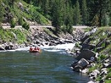
Whitewater
The Payette River is famous for its whitewaterWhitewater
Whitewater is formed in a rapid, when a river's gradient increases enough to disturb its laminar flow and create turbulence, i.e. form a bubbly, or aerated and unstable current; the frothy water appears white...
. Experts call the North Fork Class V run one of the most challenging river reaches in North America, if not the world. Kayaking
Kayaking
Kayaking is the use of a kayak for moving across water. Kayaking and canoeing are also known as paddling. Kayaking is distinguished from canoeing by the sitting position of the paddler and the number of blades on the paddle...
on the lower North Fork from Smith's Ferry to Banks is world-class, easily viewed from state highway #55, which closely hugs its bank, primarily on the west side. The lower North Fork narrows and drops 1700 feet (518 m) in the 16 miles (26 km) above Banks, providing nearly endless Class V rapids (see International Scale of River Difficulty
International Scale of River Difficulty
The International Scale of River Difficulty is a standardized scale used to rate the safety of a stretch of river, or a single rapid. The grade reflects the technical difficulty and skill level required associated with the section of river...
). The average gradient is 110 feet (33.5 m) per mile (21 m/km) with a maximum gradient of 200 ft/mile (38 m/km). The North Fork's flow rate is controlled through the Cascade Dam, completed in 1948, providing relatively warm water from the shallow Cascade Reservoir
Lake Cascade
Lake Cascade is located on the North Fork of the Payette River in Valley County, Idaho, USA, in the Boise National Forest. It is the fourth largest lake or reservoir in the state...
.
To the east of Banks, the South Fork's Canyon, west of Lowman
Lowman, Idaho
Lowman is a small unincorporated rural census-designated place in Boise County, Idaho, United States, nestled along the banks of the South Fork of the Payette River in the central part of the state...
, is a challenging Class IV run for rafting
Rafting
Rafting or white water rafting is a challenging recreational outdoor activity using an inflatable raft to navigate a river or other bodies of water. This is usually done on white water or different degrees of rough water, in order to thrill and excite the raft passengers. The development of this...
. Along this trip is a 40 feet (12.2 m) Class VI waterfall (Big Falls), which is portaged. The North Fork and South Fork merge at Banks to form the Payette River (main), providing a float trip with numerous Class III rapids. The highway
Idaho State Highway 55
State Highway 55 is an Idaho highway from Marsing to New Meadows, connecting with US-95 at both ends.From Marsing it travels east to Nampa, Meridian, and Eagle, then north to Horseshoe Bend. SH-55 then climbs the Payette River to Banks, then its north fork to the Long Valley, through the towns of...
on this lower stretch of the river is on the east bank and a scenic railroad, the Thunder Mountain Line, runs above the west side.
External links
- AllAboutRivers Payette River Page - Online rafting guide for the Payette River
- Idaho Whitewater Trail Map - official state tourism site
- Paddling.net - Payette River
- Payette River Mountains Visitor Association - Payette River Mountains Visitor Association
- American Whitewater.org - Class V: lower North Fork Payette River
- Kayak Idaho.com - Payette River photos, maps, flows.
- Payette River.org - general information & flow rates
- Payette River Scenic Byway - Corridor Plan - Idaho Transportation Dept.
- Deadwood Dam - Deadwood River into South Fork Payette River - Bureau of Reclamation
- Cascade Dam - North Fork Payette River - Bureau of Reclamation
- Black Canyon Dam - Payette River - Bureau of Reclamation
- Payette River, Snake River to Black Canyon Reservoir - Idaho Fishing Planner - Idaho Dept. of Fish & Game - Species presence, fishing rules, stocking, maps, more..
- Payette River, Black Canyon Reservoir to South Fork - Idaho Fishing Planner - Idaho Dept. of Fish & Game - Species presence, fishing rules, stocking, maps, more..