
Umpqua River
Encyclopedia
The Umpqua River (ˈʌmpkwə ) on the Pacific
coast of Oregon
in the United States
is approximately 111 miles (179 km) long. One of the principal river
s of the Oregon Coast
and known for bass and shad, the river drains an expansive network of valleys in the mountains west of the Cascade Range
and south of the Willamette Valley
, from which it is separated by the Calapooya Mountains
. From its source northwest of Roseburg
, the Umpqua flows northwest through the Oregon Coast Range
and empties into the Pacific at Winchester Bay
. The river and its tributaries flow entirely within Douglas County
, which encompasses most of the watershed of the river from the Cascades to the coast. The "Hundred Valleys of the Umpqua" form the heart of the timber industry of southern Oregon
, generally centered on Roseburg.
The Native Americans
in the Umpqua's watershed consist of several tribes, such as the Umpqua (a band of the Coquille
for which the river is named), and the Kalapuya. These tribes witnessed much of the Great Flood of 1862
, during which the Umpqua and other rivers rose to levels so high that even the oldest Indians had never seen a greater flood.
and South Umpqua
rivers rise in the Southern Oregon Cascades, and flow generally west for over 100 miles (160.9 km) to join approximately 6 miles (9.7 km) northwest of Roseburg. In modern terminology, the "Umpqua Valley" is sometimes taken to refer to the populated lower reaches of the South Umpqua south of Roseburg, along the route of Interstate 5
. The North Umpqua rises from snowmelt and is considered one of the premier summer steelhead
streams in the West.
From Roseburg, the Umpqua flows generally northwest through broad farming valleys in the Oregon Coast Range in a serpentine course past the settlement of Umpqua
and the city Elkton
. At Elkton, it turns to flow west through a narrower canyon past Scottsburg
, which is located at the head of tide
. It enters Winchester Bay on the Pacific near Reedsport
. It receives the Smith River from the north near its estuary
on Winchester Bay. The Umpqua River Light
protects ships nearing the mouth of the river.
The Umpqua is one of four major rivers in Oregon that start in or east of the Cascade Range
and reach the Pacific Ocean
. The others are the Rogue River
(in Oregon), Klamath River
(flowing from Oregon to California) and Columbia River
(flowing from British Columbia
to Washington and the Pacific between Oregon and Washington).
 In the early 19th century the river valley was largely inhabited by the Coquille tribe of Native Americans. The tribe ceded most of its land to the U.S. government in the 1854 Treaty with the Umpqua and Kalapuya, agreeing to move to a reservation in Lincoln County
as part of the Confederated Tribes of Siletz
. The river itself is named for the Umpqua, a band of the Coquille.
The Umpqua River valley was inhabited by several different bands of Indians: primarily the Athabaskan-speaking Upper Umpqua, Takelman speaking Cow Creek Band of Umpqua, the Yoncalla (a Kalapuyan people) in the north, and the Quich (Lower Umpqua) from Scottsburg/Wells Creek to the coast. The Quich spoke a language distantly related to Alsea/Yakonan and the Coos Bay languages.
In the Great Flood of 1862
, the Umpqua River had the largest flood known to all of the area's Indians at the time, and water was 10 to 15 feet higher than the 1853 flood. It rose from November 3rd to December 3rd, subsided for two days then rose again until the 9th. At Fort Umpqua, communication up river was cut off above Scottsburg, and the river was full of floating houses, barns, rails and produce. At Port Orford, the Coquille River
swept away settlers' property. Great damage also occurred on the Rogue River
and on other small streams.
Pacific Ocean
The Pacific Ocean is the largest of the Earth's oceanic divisions. It extends from the Arctic in the north to the Southern Ocean in the south, bounded by Asia and Australia in the west, and the Americas in the east.At 165.2 million square kilometres in area, this largest division of the World...
coast of Oregon
Oregon
Oregon is a state in the Pacific Northwest region of the United States. It is located on the Pacific coast, with Washington to the north, California to the south, Nevada on the southeast and Idaho to the east. The Columbia and Snake rivers delineate much of Oregon's northern and eastern...
in the United States
United States
The United States of America is a federal constitutional republic comprising fifty states and a federal district...
is approximately 111 miles (179 km) long. One of the principal river
River
A river is a natural watercourse, usually freshwater, flowing towards an ocean, a lake, a sea, or another river. In a few cases, a river simply flows into the ground or dries up completely before reaching another body of water. Small rivers may also be called by several other names, including...
s of the Oregon Coast
Oregon Coast
The Oregon Coast is a region of the U.S. state of Oregon. It runs generally north-south along the Pacific Ocean, forming the western border of the state; the region is bounded to the east by the Oregon Coast Range. The Oregon Coast stretches approximately from the Columbia River in the north to...
and known for bass and shad, the river drains an expansive network of valleys in the mountains west of the Cascade Range
Cascade Range
The Cascade Range is a major mountain range of western North America, extending from southern British Columbia through Washington and Oregon to Northern California. It includes both non-volcanic mountains, such as the North Cascades, and the notable volcanoes known as the High Cascades...
and south of the Willamette Valley
Willamette Valley
The Willamette Valley is the most populated region in the state of Oregon of the United States. Located in the state's northwest, the region is surrounded by tall mountain ranges to the east, west and south and the valley's floor is broad, flat and fertile because of Ice Age conditions...
, from which it is separated by the Calapooya Mountains
Calapooya Mountains
The Calapooya Mountains are a mountain range in Lane and Douglas counties of southwestern Oregon in the United States. The range runs for approximately west from the Cascade Range between Eugene on the north and Roseburg on the south.- Geology :...
. From its source northwest of Roseburg
Roseburg, Oregon
Roseburg is a city in the U.S. state of Oregon. It is the county seat of Douglas County. The population was 21,181 at the 2010 census.-History:...
, the Umpqua flows northwest through the Oregon Coast Range
Oregon Coast Range
The Oregon Coast Range, often called simply the Coast Range and sometimes the Pacific Coast Range, is a mountain range, in the Pacific Coast Ranges physiographic region, in the U.S. state of Oregon along the Pacific Ocean...
and empties into the Pacific at Winchester Bay
Winchester Bay, Oregon
Winchester Bay is an unincorporated community in Douglas County, Oregon, United States. For statistical purposes, the United States Census Bureau has defined Winchester Bay as a census-designated place...
. The river and its tributaries flow entirely within Douglas County
Douglas County, Oregon
-National protected areas:* Crater Lake National Park * Rogue River-Siskiyou National Forest * Siuslaw National Forest * Umpqua National Forest * Willamette National Forest -Adjacent counties:* Lane County, Oregon -...
, which encompasses most of the watershed of the river from the Cascades to the coast. The "Hundred Valleys of the Umpqua" form the heart of the timber industry of southern Oregon
Southern Oregon
Southern Oregon is a region of the U.S. state of Oregon south of Lane County and generally west of the Cascade Range, excluding the southern Oregon Coast. Counties include Douglas, Jackson, Klamath, and Josephine. It includes the Southern Oregon American Viticultural Area, which consists of the...
, generally centered on Roseburg.
The Native Americans
Native Americans in the United States
Native Americans in the United States are the indigenous peoples in North America within the boundaries of the present-day continental United States, parts of Alaska, and the island state of Hawaii. They are composed of numerous, distinct tribes, states, and ethnic groups, many of which survive as...
in the Umpqua's watershed consist of several tribes, such as the Umpqua (a band of the Coquille
Coquille (tribe)
The Coquille are a Native American tribe centered in southwest Oregon in the United States, where the Coos River flows into Coos Bay.-Name:The name of the Coquille is derived from the French, literally translated as "shell"...
for which the river is named), and the Kalapuya. These tribes witnessed much of the Great Flood of 1862
Great Flood of 1862
The Great Flood of 1862 or Noachian Deluge was the largest flood in the recorded history of Oregon, Nevada and California, occurring from December 1861 to January 1862. It was preceded by weeks of continuous rains that began in Oregon in November 1861 and continued into January 1862...
, during which the Umpqua and other rivers rose to levels so high that even the oldest Indians had never seen a greater flood.
Course
The North UmpquaNorth Umpqua River
The North Umpqua River is a tributary of the Umpqua River, approximately long, in southwestern Oregon in the United States. It drains a scenic and rugged area of the Cascade Range southwest of Eugene, flowing through steep canyons and surrounded by large Douglas-fir forests...
and South Umpqua
South Umpqua River
The South Umpqua River is a tributary of the Umpqua River, approximately long, in southwestern Oregon in the United States. It drains part of the Cascade Range east of Roseburg...
rivers rise in the Southern Oregon Cascades, and flow generally west for over 100 miles (160.9 km) to join approximately 6 miles (9.7 km) northwest of Roseburg. In modern terminology, the "Umpqua Valley" is sometimes taken to refer to the populated lower reaches of the South Umpqua south of Roseburg, along the route of Interstate 5
Interstate 5
Interstate 5 is the main Interstate Highway on the West Coast of the United States, running largely parallel to the Pacific Ocean coastline from Canada to Mexico . It serves some of the largest cities on the U.S...
. The North Umpqua rises from snowmelt and is considered one of the premier summer steelhead
Rainbow trout
The rainbow trout is a species of salmonid native to tributaries of the Pacific Ocean in Asia and North America. The steelhead is a sea run rainbow trout usually returning to freshwater to spawn after 2 to 3 years at sea. In other words, rainbow trout and steelhead trout are the same species....
streams in the West.
From Roseburg, the Umpqua flows generally northwest through broad farming valleys in the Oregon Coast Range in a serpentine course past the settlement of Umpqua
Umpqua, Oregon
Umpqua is an unincorporated community in Douglas County, Oregon, United States. The population was 112 at the 2000 census.The word "Umpqua" was first used by the local Native Americans to refer to the locality around the Umpqua River and came to be applied to the river as well....
and the city Elkton
Elkton, Oregon
Elkton is a city in Douglas County, Oregon, United States. It is located on the lower Umpqua River, at the junction of Oregon Route 38 and Oregon Route 138, about west of Interstate 5 and about west of Drain...
. At Elkton, it turns to flow west through a narrower canyon past Scottsburg
Scottsburg, Oregon
Scottsburg is an unincorporated community in Douglas County, Oregon, United States. It is located on the Umpqua River and Oregon Route 38, and is about 20 miles from the Pacific Ocean. It was once a growing town but after a large flood in December 1861 the town declined.Scottsburg was named for...
, which is located at the head of tide
Head of tide
Head of tide is the farthest point upstream where a river is affected by tidal fluctuations. This applies to rivers which flow into tidal bodies such as oceans, bays and sloughs. Though this point may vary due to storms and seasonal or annual differences in water flows, there is generally an...
. It enters Winchester Bay on the Pacific near Reedsport
Reedsport, Oregon
Reedsport is a city in Douglas County, Oregon, United States. As of the 2010 census, the population was 4,154.- History :Reedsport was established on the estuary of the Umpqua River on January 7, 1852. It was named for a local settler, Alfred W. Reed, who founded the city in 1912...
. It receives the Smith River from the north near its estuary
Estuary
An estuary is a partly enclosed coastal body of water with one or more rivers or streams flowing into it, and with a free connection to the open sea....
on Winchester Bay. The Umpqua River Light
Umpqua River Light
The Umpqua River Light is a lighthouse on the Oregon Coast of the United States, located at the mouth of the Umpqua River on Winchester Bay, in Douglas County, Oregon.-History:...
protects ships nearing the mouth of the river.
The Umpqua is one of four major rivers in Oregon that start in or east of the Cascade Range
Cascade Range
The Cascade Range is a major mountain range of western North America, extending from southern British Columbia through Washington and Oregon to Northern California. It includes both non-volcanic mountains, such as the North Cascades, and the notable volcanoes known as the High Cascades...
and reach the Pacific Ocean
Pacific Ocean
The Pacific Ocean is the largest of the Earth's oceanic divisions. It extends from the Arctic in the north to the Southern Ocean in the south, bounded by Asia and Australia in the west, and the Americas in the east.At 165.2 million square kilometres in area, this largest division of the World...
. The others are the Rogue River
Rogue River (Oregon)
The Rogue River in southwestern Oregon in the United States flows about in a generally westward direction from the Cascade Range to the Pacific Ocean. Known for its salmon runs, whitewater rafting, and rugged scenery, it was one of the original eight rivers named in the Wild and Scenic Rivers Act...
(in Oregon), Klamath River
Klamath River
The Klamath River is an American river that flows southwest through Oregon and northern California, cutting through the Cascade Range to empty into the Pacific Ocean. The river drains an extensive watershed of almost that stretches from the high desert country of the Great Basin to the temperate...
(flowing from Oregon to California) and Columbia River
Columbia River
The Columbia River is the largest river in the Pacific Northwest region of North America. The river rises in the Rocky Mountains of British Columbia, Canada, flows northwest and then south into the U.S. state of Washington, then turns west to form most of the border between Washington and the state...
(flowing from British Columbia
British Columbia
British Columbia is the westernmost of Canada's provinces and is known for its natural beauty, as reflected in its Latin motto, Splendor sine occasu . Its name was chosen by Queen Victoria in 1858...
to Washington and the Pacific between Oregon and Washington).
History
Lincoln County, Oregon
-National protected areas:*Oregon Islands National Wildlife Refuge *Siletz Bay National Wildlife Refuge*Siuslaw National Forest -Demographics:...
as part of the Confederated Tribes of Siletz
Confederated Tribes of Siletz
The Confederated Tribes of Siletz Indians in the United States is a federally recognized confederation of 27 Native American tribal bands that once inhabited a range from northern California to southwest Washington.-Tribes:...
. The river itself is named for the Umpqua, a band of the Coquille.
The Umpqua River valley was inhabited by several different bands of Indians: primarily the Athabaskan-speaking Upper Umpqua, Takelman speaking Cow Creek Band of Umpqua, the Yoncalla (a Kalapuyan people) in the north, and the Quich (Lower Umpqua) from Scottsburg/Wells Creek to the coast. The Quich spoke a language distantly related to Alsea/Yakonan and the Coos Bay languages.
In the Great Flood of 1862
Great Flood of 1862
The Great Flood of 1862 or Noachian Deluge was the largest flood in the recorded history of Oregon, Nevada and California, occurring from December 1861 to January 1862. It was preceded by weeks of continuous rains that began in Oregon in November 1861 and continued into January 1862...
, the Umpqua River had the largest flood known to all of the area's Indians at the time, and water was 10 to 15 feet higher than the 1853 flood. It rose from November 3rd to December 3rd, subsided for two days then rose again until the 9th. At Fort Umpqua, communication up river was cut off above Scottsburg, and the river was full of floating houses, barns, rails and produce. At Port Orford, the Coquille River
Coquille River
The Coquille River is a stream long, in southwestern Oregon in the United States. It drains a mountainous area of of the Southern Oregon Coast Range into the Pacific Ocean. Its watershed is located between that of the Coos River to the north and the Rogue River to the south.-Geography:The river,...
swept away settlers' property. Great damage also occurred on the Rogue River
Rogue River
Rogue River may refer to:* "Rogue River" , an episode of Jericho and the eponymous place* Rogue River , a river in Michigan, USA* Rogue River , a river in Oregon, USA* Rogue River, Oregon, a city in Oregon, USA...
and on other small streams.
Recreation
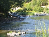
The Umpqua River boasts some of the world's best fly-fishing, salmon fishing, and sturgeon fishing. Umpqua river fishing is also famous for its small-mouth bass, striped bass, and shad population.External links
- Umpqua River in the Oregon EncyclopediaThe Oregon EncyclopediaThe Oregon Encyclopedia of History and Culture is a collaborative encyclopedia, under development, focused on the history of the U.S. state of Oregon. The encyclopedia is a project of Portland State University's History Department and the Oregon Historical Society...
- Oregon Coastal Atlas: Umpqua River Estuary
- The Umpqua Basin Explorer from Oregon State UniversityOregon State UniversityOregon State University is a coeducational, public research university located in Corvallis, Oregon, United States. The university offers undergraduate, graduate and doctoral degrees and a multitude of research opportunities. There are more than 200 academic degree programs offered through the...