

Water gap
Encyclopedia
Mountain
Image:Himalaya_annotated.jpg|thumb|right|The Himalayan mountain range with Mount Everestrect 58 14 160 49 Chomo Lonzorect 200 28 335 52 Makalurect 378 24 566 45 Mount Everestrect 188 581 920 656 Tibetan Plateaurect 250 406 340 427 Rong River...
range. Water gaps often offer a practical route for road
Road
A road is a thoroughfare, route, or way on land between two places, which typically has been paved or otherwise improved to allow travel by some conveyance, including a horse, cart, or motor vehicle. Roads consist of one, or sometimes two, roadways each with one or more lanes and also any...
and rail transport
Rail transport
Rail transport is a means of conveyance of passengers and goods by way of wheeled vehicles running on rail tracks. In contrast to road transport, where vehicles merely run on a prepared surface, rail vehicles are also directionally guided by the tracks they run on...
to cross mountain ridges.
Geology
A water gap is usually an indication of a riverRiver
A river is a natural watercourse, usually freshwater, flowing towards an ocean, a lake, a sea, or another river. In a few cases, a river simply flows into the ground or dries up completely before reaching another body of water. Small rivers may also be called by several other names, including...
that is older than the current topography. The river likely established its course when the landform was at a low elevation, with a very low stream gradient and a thick layer of unconsolidated sediment
Sediment
Sediment is naturally occurring material that is broken down by processes of weathering and erosion, and is subsequently transported by the action of fluids such as wind, water, or ice, and/or by the force of gravity acting on the particle itself....
. The river therefore established its channel without regard for the deeper layers of rock
Rock (geology)
In geology, rock or stone is a naturally occurring solid aggregate of minerals and/or mineraloids.The Earth's outer solid layer, the lithosphere, is made of rock. In general rocks are of three types, namely, igneous, sedimentary, and metamorphic...
.
A later period of uplift caused increased erosion
Erosion
Erosion is when materials are removed from the surface and changed into something else. It only works by hydraulic actions and transport of solids in the natural environment, and leads to the deposition of these materials elsewhere...
along the riverbed, exposing the underlying rock layers. As the uplift continued, the river, being large enough, continued to erode the rising land, cutting through ridges as they formed.
Water gaps are common in the ridge-and-valley Appalachians
Ridge-and-valley Appalachians
The Ridge-and-Valley Appalachians, also called the Ridge and Valley Province or the Valley and Ridge Appalachians, are a physiographic province of the larger Appalachian division and are also a belt within the Appalachian Mountains extending from southeastern New York through northwestern New...
of eastern North America
North America
North America is a continent wholly within the Northern Hemisphere and almost wholly within the Western Hemisphere. It is also considered a northern subcontinent of the Americas...
.
Alternatively, a water gap can be formed through headward erosion
Headward erosion
Headward erosion is a fluvial process of erosion that lengthens a stream, a valley or a gully at its head and also enlarges its drainage basin. The stream erodes away at the rock and soil at its headwaters in the opposite direction that it flows. Once a stream has begun to cut back, the erosion is...
of two streams on opposite sides of a ridge, ultimately resulting in the capture of one stream by the other.
Notable examples
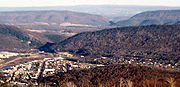
- Delaware Water GapDelaware Water GapThe Delaware Water Gap is on the border of New Jersey and Pennsylvania where the Delaware River cuts through a large ridge of the Appalachian Mountains...
, PennsylvaniaPennsylvaniaThe Commonwealth of Pennsylvania is a U.S. state that is located in the Northeastern and Mid-Atlantic regions of the United States. The state borders Delaware and Maryland to the south, West Virginia to the southwest, Ohio to the west, New York and Ontario, Canada, to the north, and New Jersey to...
and New JerseyNew JerseyNew Jersey is a state in the Northeastern and Middle Atlantic regions of the United States. , its population was 8,791,894. It is bordered on the north and east by the state of New York, on the southeast and south by the Atlantic Ocean, on the west by Pennsylvania and on the southwest by Delaware...
, United StatesUnited StatesThe United States of America is a federal constitutional republic comprising fifty states and a federal district... - Manawatu GorgeManawatu GorgeThe Manawatu Gorge runs between the Ruahine and Tararua Ranges of the North Island of New Zealand, linking the Manawatu and Hawke's Bay regions...
, New ZealandNew ZealandNew Zealand is an island country in the south-western Pacific Ocean comprising two main landmasses and numerous smaller islands. The country is situated some east of Australia across the Tasman Sea, and roughly south of the Pacific island nations of New Caledonia, Fiji, and Tonga... - Potomac Water GapPotomac Water GapThe Potomac Water Gap is a double water gap in the Blue Ridge Mountains, located at the intersection of the states of Virginia, West Virginia and Maryland, near Harpers Ferry...
, United States - Heavitree GapHeavitree GapThe Heavitree Gap, or Ntaripe in the Arrernte language, is a gap in the MacDonnell Ranges of Central Australia. It is the southern entrance to the city of Alice Springs and in addition to the Todd River it carries the main road and rail access to the South....
, Alice Springs, Australia - Numerous water gaps cutting through the North DownsNorth DownsThe North Downs are a ridge of chalk hills in south east England that stretch from Farnham in Surrey to the White Cliffs of Dover in Kent. The North Downs lie within two Areas of Outstanding Natural Beauty , the Surrey Hills and the Kent Downs...
and South DownsSouth DownsThe South Downs is a range of chalk hills that extends for about across the south-eastern coastal counties of England from the Itchen Valley of Hampshire in the west to Beachy Head, near Eastbourne, East Sussex, in the east. It is bounded on its northern side by a steep escarpment, from whose...
escarpmentEscarpmentAn escarpment is a steep slope or long cliff that occurs from erosion or faulting and separates two relatively level areas of differing elevations.-Description and variants:...
s in southern EnglandEnglandEngland is a country that is part of the United Kingdom. It shares land borders with Scotland to the north and Wales to the west; the Irish Sea is to the north west, the Celtic Sea to the south west, with the North Sea to the east and the English Channel to the south separating it from continental...
, including those of the MoleRiver Mole, SurreyThe River Mole is a tributary of the River Thames in southern England. It rises in West Sussex near Gatwick Airport and flows north west through Surrey for to the Thames near Hampton Court Palace. The river gives its name to the Surrey district of Mole Valley...
(at DorkingDorkingDorking is a historic market town at the foot of the North Downs approximately south of London, in Surrey, England.- History and development :...
) and the Great StourRiver Stour, KentThe River Stour is the river in Kent, England that flows into the English Channel at Pegwell Bay. Above Plucks Gutter, where the Little Stour joins it, the river is normally known as the Great Stour. The upper section of the river, above its confluence with the East Stour at Ashford is sometimes...
(from AshfordAshford, KentAshford is a town in the borough of Ashford in Kent, England. In 2005 it was voted the fourth best place to live in the United Kingdom. It lies on the Great Stour river, the M20 motorway, and the South Eastern Main Line and High Speed 1 railways. Its agricultural market is one of the most...
to SandwichSandwich, KentSandwich is a historic town and civil parish on the River Stour in the Non-metropolitan district of Dover, within the ceremonial county of Kent, south-east England. It has a population of 6,800....
via CanterburyCanterburyCanterbury is a historic English cathedral city, which lies at the heart of the City of Canterbury, a district of Kent in South East England. It lies on the River Stour....
).
See also
- Antecedent drainage streamAntecedent drainage streamAn antecedent stream or antecedent drainage is a stream that follows a course that formed before the tectonic uplift of the surrounding terrain and maintained its course through continuous downcutting of its valley. Also referred to as a "superposed stream."...
- Defile (geography)Defile (geography)Defile is a geographic term for a narrow pass or gorge between mountains or hills. It has its origins as a military description of a pass through which troops can march only in a narrow column or with a narrow front...
- PeneplainPeneplainA peneplain is a low-relief plain representing the final stage of fluvial erosion during times of extended tectonic stability. The existence of peneplains, and peneplanation as a geomorphological process, is not without controversy, due to a lack of contemporary examples and uncertainty in...
- Wind gap (topography)