

North American Plate
Encyclopedia
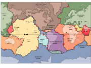
North America
North America is a continent wholly within the Northern Hemisphere and almost wholly within the Western Hemisphere. It is also considered a northern subcontinent of the Americas...
, Greenland
Greenland
Greenland is an autonomous country within the Kingdom of Denmark, located between the Arctic and Atlantic Oceans, east of the Canadian Arctic Archipelago. Though physiographically a part of the continent of North America, Greenland has been politically and culturally associated with Europe for...
, Cuba
Cuba
The Republic of Cuba is an island nation in the Caribbean. The nation of Cuba consists of the main island of Cuba, the Isla de la Juventud, and several archipelagos. Havana is the largest city in Cuba and the country's capital. Santiago de Cuba is the second largest city...
, Bahamas, and parts of Siberia
Siberia
Siberia is an extensive region constituting almost all of Northern Asia. Comprising the central and eastern portion of the Russian Federation, it was part of the Soviet Union from its beginning, as its predecessor states, the Tsardom of Russia and the Russian Empire, conquered it during the 16th...
, Japan
Japan
Japan is an island nation in East Asia. Located in the Pacific Ocean, it lies to the east of the Sea of Japan, China, North Korea, South Korea and Russia, stretching from the Sea of Okhotsk in the north to the East China Sea and Taiwan in the south...
and Iceland
Iceland
Iceland , described as the Republic of Iceland, is a Nordic and European island country in the North Atlantic Ocean, on the Mid-Atlantic Ridge. Iceland also refers to the main island of the country, which contains almost all the population and almost all the land area. The country has a population...
. It extends eastward to the Mid-Atlantic Ridge
Mid-Atlantic Ridge
The Mid-Atlantic Ridge is a mid-ocean ridge, a divergent tectonic plate boundary located along the floor of the Atlantic Ocean, and part of the longest mountain range in the world. It separates the Eurasian Plate and North American Plate in the North Atlantic, and the African Plate from the South...
and westward to the Chersky Range
Chersky Range
The Chersky Range is a chain of mountains in northeastern Siberia between the Yana River and the Indigirka River. It generally runs from northwest to southeast through the Sakha Republic and Magadan Oblast. The tallest mountain in the range is Peak Pobeda, which is 3,003 meters tall. The range...
in eastern Siberia. The plate includes both continental
Continental crust
The continental crust is the layer of igneous, sedimentary, and metamorphic rocks which form the continents and the areas of shallow seabed close to their shores, known as continental shelves. This layer is sometimes called sial due to more felsic, or granitic, bulk composition, which lies in...
and oceanic crust
Oceanic crust
Oceanic crust is the part of Earth's lithosphere that surfaces in the ocean basins. Oceanic crust is primarily composed of mafic rocks, or sima, which is rich in iron and magnesium...
. The interior of the main continental landmass includes an extensive granitic
Granite
Granite is a common and widely occurring type of intrusive, felsic, igneous rock. Granite usually has a medium- to coarse-grained texture. Occasionally some individual crystals are larger than the groundmass, in which case the texture is known as porphyritic. A granitic rock with a porphyritic...
core called a craton
Craton
A craton is an old and stable part of the continental lithosphere. Having often survived cycles of merging and rifting of continents, cratons are generally found in the interiors of tectonic plates. They are characteristically composed of ancient crystalline basement rock, which may be covered by...
. Along most of the edges of this craton are fragments of crustal material called terrane
Terrane
A terrane in geology is short-hand term for a tectonostratigraphic terrane, which is a fragment of crustal material formed on, or broken off from, one tectonic plate and accreted or "sutured" to crust lying on another plate...
s, accreted to the craton by tectonic actions over the long span of geologic time. It is believed that much of North America west of the Rockies
Rocky Mountains
The Rocky Mountains are a major mountain range in western North America. The Rocky Mountains stretch more than from the northernmost part of British Columbia, in western Canada, to New Mexico, in the southwestern United States...
is composed of such terranes.
Geographic extent
The easterly side of the North American Plate is a divergent boundaryDivergent boundary
In plate tectonics, a divergent boundary or divergent plate boundary is a linear feature that exists between two tectonic plates that are moving away from each other. Divergent boundaries within continents initially produce rifts which produce rift valleys...
with the Eurasian Plate
Eurasian Plate
The Eurasian Plate is a tectonic plate which includes most of the continent of Eurasia , with the notable exceptions of the Indian subcontinent, the Arabian subcontinent, and the area east of the Chersky Range in East Siberia...
to the north and the African Plate
African Plate
The African Plate is a tectonic plate which includes the continent of Africa, as well as oceanic crust which lies between the continent and various surrounding ocean ridges.-Boundaries:...
to the south forming the northern part of the Mid-Atlantic Ridge
Mid-Atlantic Ridge
The Mid-Atlantic Ridge is a mid-ocean ridge, a divergent tectonic plate boundary located along the floor of the Atlantic Ocean, and part of the longest mountain range in the world. It separates the Eurasian Plate and North American Plate in the North Atlantic, and the African Plate from the South...
.
The southerly boundary with the Cocos Plate
Cocos Plate
The Cocos Plate is an oceanic tectonic plate beneath the Pacific Ocean off the west coast of Central America, named for Cocos Island, which rides upon it.-Geology:...
to the west and the Caribbean Plate
Caribbean Plate
The Caribbean Plate is a mostly oceanic tectonic plate underlying Central America and the Caribbean Sea off the north coast of South America....
to the east is a transform fault
Transform fault
A transform fault or transform boundary, also known as conservative plate boundary since these faults neither create nor destroy lithosphere, is a type of fault whose relative motion is predominantly horizontal in either sinistral or dextral direction. Furthermore, transform faults end abruptly...
, represented by the Cayman Trench under the Caribbean Sea
Caribbean Sea
The Caribbean Sea is a sea of the Atlantic Ocean located in the tropics of the Western hemisphere. It is bounded by Mexico and Central America to the west and southwest, to the north by the Greater Antilles, and to the east by the Lesser Antilles....
and the Motagua Fault
Motagua Fault
The Motagua Fault is a major, active left lateral-moving transform fault which cuts across Guatemala. It forms part of the tectonic boundary between the North American Plate and the Caribbean Plate...
through Guatemala
Guatemala
Guatemala is a country in Central America bordered by Mexico to the north and west, the Pacific Ocean to the southwest, Belize to the northeast, the Caribbean to the east, and Honduras and El Salvador to the southeast...
. The parallel Septentrional
Septentrional-Oriente fault zone
The Septentrional-Orient fault zone is a system of coaxial left lateral-moving strike slip faults which runs along the northern side of the island of Hispaniola where the Dominican Republic and Haiti are located...
and Enriquillo-Plantain Garden fault
Enriquillo-Plantain Garden fault zone
The Enriquillo–Plantain Garden fault zone is a system of coaxial left lateral-moving strike slip faults which runs along the southern side of the island of Hispaniola, where the Dominican Republic and Haiti are located...
s, which run through the island of Hispaniola
Hispaniola
Hispaniola is a major island in the Caribbean, containing the two sovereign states of the Dominican Republic and Haiti. The island is located between the islands of Cuba to the west and Puerto Rico to the east, within the hurricane belt...
and bound the Gonâve Microplate
Gonâve Microplate
The Gonâve Microplate forms part of the boundary between the North American Plate and the Caribbean Plate. It is bounded to the west by the Cayman spreading center, to the north by the Septentrional-Oriente fault zone and to the south by the Walton fault zone and the Enriquillo-Plantain Garden...
, are also a part of the boundary. The rest of the southerly margin which extends east to the Mid Atlantic Ridge and marks the boundary between the North American Plate and the South American Plate remains poorly understood and undefined.
On the northerly boundary is a continuation of the Mid-Atlantic ridge called the Gakkel Ridge
Gakkel Ridge
The Gakkel Ridge is a mid-oceanic ridge, a divergent tectonic plate boundary between the North American Plate and the Eurasian Plate. It is located in the Arctic Ocean between Greenland and Siberia, and has a length of about 1,800 kilometers...
. The rest of the boundary in the far northwestern part of the plate extends into Siberia
Siberia
Siberia is an extensive region constituting almost all of Northern Asia. Comprising the central and eastern portion of the Russian Federation, it was part of the Soviet Union from its beginning, as its predecessor states, the Tsardom of Russia and the Russian Empire, conquered it during the 16th...
. This boundary continues from the end of the Gakkel Ridge as the Laptev Sea Rift
Laptev Sea Rift
The Laptev Sea Rift is a divergent tectonic plate boundary between the North American Plate and the Eurasian Plate located on the Arctic Ocean coast of northeastern Siberia in Russia. The Laptev Sea Rift is the continuation of the Gakkel Ridge into the continental crust of Siberia...
, on to a transitional deformation zone in the Chersky Range
Chersky Range
The Chersky Range is a chain of mountains in northeastern Siberia between the Yana River and the Indigirka River. It generally runs from northwest to southeast through the Sakha Republic and Magadan Oblast. The tallest mountain in the range is Peak Pobeda, which is 3,003 meters tall. The range...
, then the Ulakhan Fault
Ulakhan Fault
The Ulakhan Fault is a left-lateral moving transform fault which runs along the boundary between two tectonic plates in northeast Asia, the North American Plate, and the Okhotsk Plate. It runs from a triple junction in the Chersky Range in the west, to another triple junction with the Aleutian...
between it and the Okhotsk Plate
Okhotsk Plate
The Okhotsk Plate is a tectonic plate covering the Sea of Okhotsk, the Kamchatka Peninsula, Sakhalin Island and Tōhoku and Hokkaidō in Japan. It was formerly considered a part of the North American Plate, but recent studies indicate that it is an independent plate, bounded on the north by the...
, and finally the Aleutian Trench
Aleutian Trench
The Aleutian Trench is a subduction zone and oceanic trench which runs along the southern coastline of Alaska and the adjacent waters of northeastern Siberia off the coast of Kamchatka Peninsula. It is classified as a "marginal trench" in the east as it runs along the margin of the continent, and...
to the end of the Queen Charlotte Fault
Queen Charlotte Fault
The Queen Charlotte Fault is an active transform fault, located between the North American Plate and the Pacific Plate, Canada's equivalent of the San Andreas Fault. The Queen Charlotte Fault forms a triple junction on its south with the Cascadia subduction zone and the Explorer Ridge...
system.
The westerly boundary is the Queen Charlotte Fault
Queen Charlotte Fault
The Queen Charlotte Fault is an active transform fault, located between the North American Plate and the Pacific Plate, Canada's equivalent of the San Andreas Fault. The Queen Charlotte Fault forms a triple junction on its south with the Cascadia subduction zone and the Explorer Ridge...
running offshore along the coast of Alaska and the Cascadia subduction zone
Cascadia subduction zone
The Cascadia subduction zone is a subduction zone, a type of convergent plate boundary that stretches from northern Vancouver Island to northern California. It is a very long sloping fault that separates the Juan de Fuca and North America plates.New ocean floor is being created offshore of...
to the north, the San Andreas Fault
San Andreas Fault
The San Andreas Fault is a continental strike-slip fault that runs a length of roughly through California in the United States. The fault's motion is right-lateral strike-slip...
through California
California
California is a state located on the West Coast of the United States. It is by far the most populous U.S. state, and the third-largest by land area...
, the East Pacific Rise
East Pacific Rise
The East Pacific Rise is a mid-oceanic ridge, a divergent tectonic plate boundary located along the floor of the Pacific Ocean. It separates the Pacific Plate to the west from the North American Plate, the Rivera Plate, the Cocos Plate, the Nazca Plate, and the Antarctic Plate...
in the Gulf of California
Gulf of California
The Gulf of California is a body of water that separates the Baja California Peninsula from the Mexican mainland...
, and the Middle America Trench
Middle America Trench
The Middle America Trench is a major subduction zone, an oceanic trench in the eastern Pacific Ocean off the southwestern coast of Middle America, stretching from central Mexico to Costa Rica...
to the south.
On its western edge the Farallon Plate
Farallon Plate
The Farallon Plate was an ancient oceanic plate, which began subducting under the west coast of the North American Plate— then located in modern Utah— as Pangaea broke apart during the Jurassic Period...
has been subducting
Subduction
In geology, subduction is the process that takes place at convergent boundaries by which one tectonic plate moves under another tectonic plate, sinking into the Earth's mantle, as the plates converge. These 3D regions of mantle downwellings are known as "Subduction Zones"...
under the North American Plate since the Jurassic
Jurassic
The Jurassic is a geologic period and system that extends from about Mya to Mya, that is, from the end of the Triassic to the beginning of the Cretaceous. The Jurassic constitutes the middle period of the Mesozoic era, also known as the age of reptiles. The start of the period is marked by...
Period. The Farallon Plate has almost completely subducted beneath the western portion of the North American Plate leaving that part of the North American Plate in contact with the Pacific Plate
Pacific Plate
The Pacific Plate is an oceanic tectonic plate that lies beneath the Pacific Ocean. At 103 million square kilometres, it is the largest tectonic plate....
as the San Andreas Fault
San Andreas Fault
The San Andreas Fault is a continental strike-slip fault that runs a length of roughly through California in the United States. The fault's motion is right-lateral strike-slip...
. The Juan de Fuca
Juan de Fuca Plate
The Juan de Fuca Plate, named after the explorer of the same name, is a tectonic plate, generated from the Juan de Fuca Ridge, and subducting under the northerly portion of the western side of the North American Plate at the Cascadia subduction zone...
, Explorer
Explorer Plate
The Explorer Plate is an oceanic tectonic plate beneath the Pacific Ocean off the west coast of Vancouver Island, Canada.The eastern boundary of the Explorer Plate is being slowly subducted under the North American Plate, to which it may eventually accrete owing to the slow rate of subduction...
, Gorda
Gorda Plate
The Gorda Plate, located beneath the Pacific Ocean off the coast of northern California, is one of the northern remnants of the Farallon Plate. It is sometimes referred to as simply the southernmost portion of the neighboring Juan de Fuca Plate, another Farallon remnant.Unlike most tectonic...
, Cocos
Cocos Plate
The Cocos Plate is an oceanic tectonic plate beneath the Pacific Ocean off the west coast of Central America, named for Cocos Island, which rides upon it.-Geology:...
and Nazca Plate
Nazca Plate
]The Nazca Plate, named after the Nazca region of southern Peru, is an oceanic tectonic plate in the eastern Pacific Ocean basin off the west coast of South America. The ongoing subduction along the Peru-Chile Trench of the Nazca Plate under the South American Plate is largely responsible for the...
s are remnants of the Farallon Plate.
The boundary along the Gulf of California
Gulf of California
The Gulf of California is a body of water that separates the Baja California Peninsula from the Mexican mainland...
is complex. The Gulf is underlain by the Gulf of California Rift Zone
Gulf of California Rift Zone
The Gulf of California Rift Zone is the northernmost extension of the East Pacific Rise which extends some 1300 km from the mouth of the Gulf of California to the southern terminus of the San Andreas Fault at the Salton Sink....
, a series of rift basins and transform fault segments between the northern end of the East Pacific Rise
East Pacific Rise
The East Pacific Rise is a mid-oceanic ridge, a divergent tectonic plate boundary located along the floor of the Pacific Ocean. It separates the Pacific Plate to the west from the North American Plate, the Rivera Plate, the Cocos Plate, the Nazca Plate, and the Antarctic Plate...
in the mouth of the gulf to the San Andreas Fault
San Andreas Fault
The San Andreas Fault is a continental strike-slip fault that runs a length of roughly through California in the United States. The fault's motion is right-lateral strike-slip...
system in the vicinity of the Salton Trough
Salton Sink
The Salton Sink is a geographic sink in the Coachella and Imperial valleys of southeastern California. It is in the Colorado Desert subregion of the Sonoran Desert ecoregion...
rift/Brawley seismic zone
Brawley seismic zone
The Brawley Seismic Zone , also known as the Brawley fault zone, is a predominantly extensional tectonic zone that connects the southern terminus of the San Andreas Fault with the Imperial Fault in Southern California...
.
It is generally accepted that a piece of the North American Plate was broken off and transported north as the East Pacific Rise propagated northward, creating the Gulf of California. However, it is as yet unclear whether the oceanic crust east of the Rise and west of the mainland coast of Mexico is actually a new plate beginning to converge with the North American Plate, consistent with the standard model of rift zone spreading centers generally.
Hotspots
A few hotspotHotspot (geology)
The places known as hotspots or hot spots in geology are volcanic regions thought to be fed by underlying mantle that is anomalously hot compared with the mantle elsewhere. They may be on, near to, or far from tectonic plate boundaries. There are two hypotheses to explain them...
s are thought to exist below the North American Plate. The most notable hotspots are the Yellowstone
Yellowstone Caldera
The Yellowstone Caldera is the volcanic caldera located in Yellowstone National Park in the United States, sometimes referred to as the Yellowstone Supervolcano. The caldera is located in the northwest corner of Wyoming, in which the vast majority of the park is contained. The major features of...
(Wyoming), Raton
Raton hotspot
The Raton hotspot is a volcanic hotspot which is responsible for the volcanic activity which forms the volcanoes in northeastern New Mexico, United States....
(New Mexico), and Anahim hotspot
Anahim hotspot
The Anahim hotspot is a volcanic hotspot in central British Columbia, Canada. It is situated on the Interior Plateau, a large region that lies between the Cariboo and Monashee Mountains to the east, and the Hazelton Mountains, Coast Mountains and Cascade Range to the west...
s (British Columbia). These are thought to be caused by a narrow stream of hot
Heat
In physics and thermodynamics, heat is energy transferred from one body, region, or thermodynamic system to another due to thermal contact or thermal radiation when the systems are at different temperatures. It is often described as one of the fundamental processes of energy transfer between...
mantle
Mantle (geology)
The mantle is a part of a terrestrial planet or other rocky body large enough to have differentiation by density. The interior of the Earth, similar to the other terrestrial planets, is chemically divided into layers. The mantle is a highly viscous layer between the crust and the outer core....
convecting
Convection
Convection is the movement of molecules within fluids and rheids. It cannot take place in solids, since neither bulk current flows nor significant diffusion can take place in solids....
up the Earth's core-mantle boundary
Core-mantle boundary
The core–mantle boundary lies between the Earth's silicate mantle and its liquid iron-nickel outer core. This boundary is located at approximately 2900 km of depth beneath the Earth's surface. The boundary is observed via the discontinuity in seismic wave velocities at that depth...
called a mantle plume
Mantle plume
A mantle plume is a hypothetical thermal diapir of abnormally hot rock that nucleates at the core-mantle boundary and rises through the Earth's mantle. Such plumes were invoked in 1971 to explain volcanic regions that were not thought to be explicable by the then-new theory of plate tectonics. Some...
, although some geologists prefer upper-mantle convection as a cause. The Yellowstone and Anahim hotspots are thought to have first arrived during the Miocene
Miocene
The Miocene is a geological epoch of the Neogene Period and extends from about . The Miocene was named by Sir Charles Lyell. Its name comes from the Greek words and and means "less recent" because it has 18% fewer modern sea invertebrates than the Pliocene. The Miocene follows the Oligocene...
period and are still geologically active, creating earthquake
Earthquake
An earthquake is the result of a sudden release of energy in the Earth's crust that creates seismic waves. The seismicity, seismism or seismic activity of an area refers to the frequency, type and size of earthquakes experienced over a period of time...
s and volcano
Volcano
2. Bedrock3. Conduit 4. Base5. Sill6. Dike7. Layers of ash emitted by the volcano8. Flank| 9. Layers of lava emitted by the volcano10. Throat11. Parasitic cone12. Lava flow13. Vent14. Crater15...
es. The Yellowstone hotspot is most notable for the Yellowstone Caldera
Yellowstone Caldera
The Yellowstone Caldera is the volcanic caldera located in Yellowstone National Park in the United States, sometimes referred to as the Yellowstone Supervolcano. The caldera is located in the northwest corner of Wyoming, in which the vast majority of the park is contained. The major features of...
and the many caldera
Caldera
A caldera is a cauldron-like volcanic feature usually formed by the collapse of land following a volcanic eruption, such as the one at Yellowstone National Park in the US. They are sometimes confused with volcanic craters...
s that lie in the Snake River Plain
Snake River Plain
The Snake River Plain is a geologic feature located primarily within the state of Idaho in the United States of America. It stretches about westward from northwest of the state of Wyoming to the Idaho-Oregon border. The plain is a wide flat bow-shaped depression, and covers about a quarter of Idaho...
while the Anahim hotspot is most notable for the Anahim Volcanic Belt
Anahim Volcanic Belt
The Anahim Volcanic Belt is a long volcanic belt, stretching from just north of Vancouver Island to near Quesnel, British Columbia, Canada. The Anahim Volcanic Belt has had three main magmatic episodes: 15–13 Ma, 9–6 Ma, and 3–1 Ma. The volcanoes generally become younger eastward at a rate of to ...
, currently found in the Nazko Cone
Nazko Cone
Nazko Cone is a small potentially active basaltic cinder cone in central British Columbia, Canada, located 75 km west of Quesnel and 150 kilometers southwest of Prince George. It is considered the easternmost volcano in the Anahim Volcanic Belt. The small tree-covered cone rises 120 m above...
area.
Plate motion
For the most part, the North American Plate moves in roughly a southwest direction away from the Mid-Atlantic Ridge.The motion of the plate cannot be driven by subduction as no part of the North American Plate is being subducted, except for a very small section comprising part of the Puerto Rico Trench
Puerto Rico Trench
The Puerto Rico Trench is an oceanic trench located on the boundary between the Caribbean Sea and the Atlantic Ocean. The trench is associated with a complex transition between the subduction zone to the south along the Lesser Antilles island arc and the major transform fault zone or plate boundary...
; thus other mechanisms continue to be investigated.
One recent study suggests that a mantle convective current is propelling the plate.