

Endorheic
Encyclopedia
Drainage basin
A drainage basin is an extent or an area of land where surface water from rain and melting snow or ice converges to a single point, usually the exit of the basin, where the waters join another waterbody, such as a river, lake, reservoir, estuary, wetland, sea, or ocean...
that retains water and allows no outflow to other bodies of water such as river
River
A river is a natural watercourse, usually freshwater, flowing towards an ocean, a lake, a sea, or another river. In a few cases, a river simply flows into the ground or dries up completely before reaching another body of water. Small rivers may also be called by several other names, including...
s or ocean
Ocean
An ocean is a major body of saline water, and a principal component of the hydrosphere. Approximately 71% of the Earth's surface is covered by ocean, a continuous body of water that is customarily divided into several principal oceans and smaller seas.More than half of this area is over 3,000...
s. Normally, water that has accrued in a drainage basin eventually flows out through rivers or streams on Earth's surface or by underground diffusion
Diffusion
Molecular diffusion, often called simply diffusion, is the thermal motion of all particles at temperatures above absolute zero. The rate of this movement is a function of temperature, viscosity of the fluid and the size of the particles...
through permeable
Permeability (fluid)
Permeability in fluid mechanics and the earth sciences is a measure of the ability of a porous material to allow fluids to pass through it.- Units :...
rock, ultimately ending up in the oceans. However, in an endorheic basin, rain
Rain
Rain is liquid precipitation, as opposed to non-liquid kinds of precipitation such as snow, hail and sleet. Rain requires the presence of a thick layer of the atmosphere to have temperatures above the melting point of water near and above the Earth's surface...
(or other precipitation
Precipitation (meteorology)
In meteorology, precipitation In meteorology, precipitation In meteorology, precipitation (also known as one of the classes of hydrometeors, which are atmospheric water phenomena is any product of the condensation of atmospheric water vapor that falls under gravity. The main forms of precipitation...
) that falls within it does not flow out but may only leave the drainage system by evaporation
Evaporation
Evaporation is a type of vaporization of a liquid that occurs only on the surface of a liquid. The other type of vaporization is boiling, which, instead, occurs on the entire mass of the liquid....
and seepage. The bottom of such a basin is typically occupied by a salt lake
Salt lake
A salt lake or saline lake is a landlocked body of water which has a concentration of salts and other dissolved minerals significantly higher than most lakes . In some cases, salt lakes have a higher concentration of salt than sea water, but such lakes would also be termed hypersaline lakes...
or salt pan
Salt pan (geology)
Natural salt pans are flat expanses of ground covered with salt and other minerals, usually shining white under the sun. They are found in deserts, and should not be confused with salt evaporation ponds.A salt pan is formed where water pools...
. Endorheic basins are also called internal drainage systems.
Endorheic regions, in contrast to exorheic regions which flow to the ocean in geologically defined patterns, are closed hydrologic systems. Their surface waters drain to inland terminal locations where the water evaporates or seeps into the ground, having no access to discharge into the sea. Endorheic water bodies include some of the largest lakes in the world, such as the Aral Sea
Aral Sea
The Aral Sea was a lake that lay between Kazakhstan in the north and Karakalpakstan, an autonomous region of Uzbekistan, in the south...
and the Caspian Sea
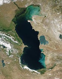
Caspian Sea
The Caspian Sea is the largest enclosed body of water on Earth by area, variously classed as the world's largest lake or a full-fledged sea. The sea has a surface area of and a volume of...
, the world’s largest saline
Saline water
Saline water is a general term for water that contains a significant concentration of dissolved salts . The concentration is usually expressed in parts per million of salt....
body of water cut off from the ocean.
Endorheic lakes
Endorheic lakes are bodies of water that do not flow into the sea. Most of the water falling on earth finds its way to the oceans through a network of rivers, lakes and wetlands. However, there is a class of water bodies that are located in closed or endorheic watersheds where the topography prevents their drainage to the oceans. These endorheic watersheds (containing water in rivers or lakes that form a balance of surface inflows, evaporation and seepage) are often called terminal lakes or sink lakes.Endorheic lakes are usually in the interior of a body mass, far from an ocean. Their watersheds are often confined by natural geologic land formations such as a mountain range, cutting off water access to the ocean. The inland water flows into dry watersheds where the water evaporates, leaving a high concentration of minerals and other inflow erosion products. Over time this input of erosion products can cause the endorheic lake to become relatively saline (a "salt lake"). Since the main outflow pathways of these lakes are chiefly through evaporation and seepage, endorheic lakes are usually more sensitive to environmental pollutants inputs than water bodies that have access to oceans.
Occurrence
Endorheic regions can occur in any climate but are most commonly found in hot desertDesert
A desert is a landscape or region that receives an extremely low amount of precipitation, less than enough to support growth of most plants. Most deserts have an average annual precipitation of less than...
locations. In areas where rainfall is higher, riparian erosion will generally carve drainage channels (particularly in times of flood), or cause the water level in the terminal lake to rise until it finds an outlet, breaking the enclosed endorheic hydrological system’s geographical barrier and opening it to the surrounding terrain. The Black Sea
Black Sea
The Black Sea is bounded by Europe, Anatolia and the Caucasus and is ultimately connected to the Atlantic Ocean via the Mediterranean and the Aegean seas and various straits. The Bosphorus strait connects it to the Sea of Marmara, and the strait of the Dardanelles connects that sea to the Aegean...
was likely such a lake, having once been an independent hydrological system before the Mediterranean Sea
Mediterranean Sea
The Mediterranean Sea is a sea connected to the Atlantic Ocean surrounded by the Mediterranean region and almost completely enclosed by land: on the north by Anatolia and Europe, on the south by North Africa, and on the east by the Levant...
broke through the terrain separating the two.
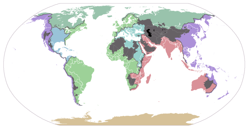
Endorheic regions tend to be far inland with their boundaries defined by mountains or other geological features that block their access to oceans. Since the inflowing water can evacuate only through seepage or evaporation, dried minerals or other products collect in the basin, eventually making the water saline and also making the basin vulnerable to pollution. Continents vary in their concentration of endorheic regions due to conditions of geography and climate. Australia has the highest percentage of endorheic regions at 21 percent while North America has the least at 5 percent. Approximately 18 percent of the earth’s land drains to endorheic lakes or seas, the largest of these land areas being the interior of Asia.
In deserts, water inflow is low and loss to solar evaporation high, drastically reducing the formation of complete drainage systems
Drainage system (Geomorphology)
In geomorphology, a drainage system is the pattern formed by the streams, rivers, and lakes in a particular drainage basin. They are governed by the topography of the land, whether a particular region is dominated by hard or soft rocks, and the gradient of the land. Geomorphologists and...
. Closed water flow areas often lead to the concentration of salts and other minerals in the basin. Minerals leached from the surrounding rocks are deposited in the basin, and left behind when the water evaporates. Thus endorheic basins often contain extensive salt pan
Salt pan (geology)
Natural salt pans are flat expanses of ground covered with salt and other minerals, usually shining white under the sun. They are found in deserts, and should not be confused with salt evaporation ponds.A salt pan is formed where water pools...
s (also called salt flats, salt lakes, alkali flats, dry lake beds or playas). These areas tend to be large, flat hardened surfaces and are sometimes used for aviation
Aviation
Aviation is the design, development, production, operation, and use of aircraft, especially heavier-than-air aircraft. Aviation is derived from avis, the Latin word for bird.-History:...
runway
Runway
According to ICAO a runway is a "defined rectangular area on a land aerodrome prepared for the landing and take-off of aircraft." Runways may be a man-made surface or a natural surface .- Orientation and dimensions :Runways are named by a number between 01 and 36, which is generally one tenth...
s or land speed record
Land speed record
The land speed record is the highest speed achieved by a wheeled vehicle on land. There is no single body for validation and regulation; in practice the Category C flying start regulations are used, officiated by regional or national organizations under the auspices of the Fédération...
attempts, because of their extensive areas of perfectly level terrain.
Both permanent and seasonal endorheic lakes can form in endorheic basins. Some endorheic basins are essentially stable, climate change having reduced precipitation to the degree that a lake no longer forms. Even most permanent endorheic lakes change size and shape dramatically over time, often becoming much smaller or breaking into several smaller parts during the dry season. As humans have expanded into previously uninhabitable desert areas, the river systems that feed many endorheic lakes have been altered by the construction of dams and aqueducts. As a result many endorheic lakes in developed or developing countries have contracted dramatically, resulting in increased salinity, higher concentrations of pollutants, and the disruption of ecosystems.
Even within exorheic basins, there can be "non-contributing", low-lying areas that trap runoff and prevent it from contributing to flows downstream during years of average or below-average runoff. In flat river basins, non-contributing areas can be a large fraction of the driver basin. (E.g. Lake Winnipeg
Lake Winnipeg
Lake Winnipeg is a large, lake in central North America, in the province of Manitoba, Canada, with its southern tip about north of the city of Winnipeg...
's basin.)
Notable endorheic basins and lakes
Antarctica
Endorheic lakes in Antarctica are located in the McMurdo Dry ValleysMcMurdo Dry Valleys
The McMurdo Dry Valleys are a row of snow-free valleys in Antarctica located within Victoria Land west of McMurdo Sound. The region is one of the world's most extreme deserts, and includes many interesting features including Lake Vida and the Onyx River, Antarctica's longest river.-Climate:The Dry...
, Victoria Land
Victoria Land
Victoria Land is a region of Antarctica bounded on the east by the Ross Ice Shelf and the Ross Sea and on the west by Oates Land and Wilkes Land. It was discovered by Captain James Clark Ross in January 1841 and named after the UK's Queen Victoria...
, Antarctica, the largest ice-free area in Antarctica.
- Don Juan PondDon Juan PondDon Juan Pond, also called Lake Don Juan, is a small and very shallow hypersaline lake in the west end of Wright Valley , Victoria Land, Antarctica, west from Lake Vanda. It is wedged between the Asgard Range in the south and the Dais in the north. On the west end there is a small tributary and a...
in Wright ValleyWright ValleyThe Wright Valley is the central one of the three large Dry Valleys in the Transantarctic Mountains, located west of McMurdo Sound at approximately . Wright Valley contains the Onyx River, the largest river in Antarctica, Lake Brownworth, the origin of Onyx River, and Lake Vanda, which is fed by...
is fed by groundwater from a rock glacier and remains unfrozen throughout the year. - Lake VandaLake VandaLake Vanda is a lake in Wright Valley, Victoria Land, Ross Dependency, Antarctica. The lake is 5 km long and has a maximum depth of 69 m. On its shore, New Zealand maintained Vanda Station from 1968 to 1995...
in Wright ValleyWright ValleyThe Wright Valley is the central one of the three large Dry Valleys in the Transantarctic Mountains, located west of McMurdo Sound at approximately . Wright Valley contains the Onyx River, the largest river in Antarctica, Lake Brownworth, the origin of Onyx River, and Lake Vanda, which is fed by...
has a perennial ice cover, the edges of which melt in the summer allowing flow from the longest river in Antarctica, the Onyx RiverOnyx RiverThe Onyx River is a meltwater stream which flows westward through the Wright Valley from Wright Lower Glacier and Lake Brownworth at the foot of the glacier to Lake Vanda, during a few months of the Antarctic summer....
. The lake is over 70 m deep and is hypersaline. - Lake BonneyLake Bonney (Antarctica)Lake Bonney is a saline lake with permanent ice cover at the western end of Taylor Valley in the McMurdo Dry Valleys of Victoria Land, Antarctica.It is long and up to wide...
is in Taylor ValleyTaylor ValleyTaylor Valley is the southern one of the three large Dry Valleys in the Transantarctic Mountains, Victoria Land, located west of McMurdo Sound at approximately . The valley extends from Taylor Glacier in the west to McMurdo Sound at Explorers Cove at the northwest head of New Harbour in the east...
and has a perennial ice cover and two lobes separated by the Bonney Riegel. The lake is fed by glacial melt and discharge from Blood FallsBlood FallsBlood Falls is an outflow of an iron oxide-tainted plume of saltwater, occurring at the tongue of the Taylor Glacier onto the ice-covered surface of West Lake Bonney in the Taylor Valley of the McMurdo Dry Valleys in Victoria Land, East Antarctica....
. Its unique glacial history has resulted in a hypersaline brine in the bottom waters and fresh water at the surface. - Lake HoareLake HoareLake Hoare is a lake about long between Lake Chad and Canada Glacier in Taylor Valley, Victoria Land. Its surface area measures . It was named by the 8th Victoria University of Wellington Antarctic Expedition , 1963–64, for physicist R.A...
, in Taylor ValleyTaylor ValleyTaylor Valley is the southern one of the three large Dry Valleys in the Transantarctic Mountains, Victoria Land, located west of McMurdo Sound at approximately . The valley extends from Taylor Glacier in the west to McMurdo Sound at Explorers Cove at the northwest head of New Harbour in the east...
, is the freshest of the Dry Valley lakes receiving its melt almost exclusively from the Canada Glacier. The lake has an ice cover and forms a moat during the Austral summer. - Lake FryxellLake FryxellLake Fryxell is a lake long, between Canada Glacier and Commonwealth Glaciers at the lower end of Taylor Valley in Victoria Land, Antarctica. Mapped by the British Antarctic Expedition under Robert Falcon Scott, 1910-13, the lake was visited by Professor T.L. Péwé during USN Operation Deep Freeze,...
, is adjacent to the Ross SeaRoss SeaThe Ross Sea is a deep bay of the Southern Ocean in Antarctica between Victoria Land and Marie Byrd Land.-Description:The Ross Sea was discovered by James Ross in 1841. In the west of the Ross Sea is Ross Island with the Mt. Erebus volcano, in the east Roosevelt Island. The southern part is covered...
in Taylor ValleyTaylor ValleyTaylor Valley is the southern one of the three large Dry Valleys in the Transantarctic Mountains, Victoria Land, located west of McMurdo Sound at approximately . The valley extends from Taylor Glacier in the west to McMurdo Sound at Explorers Cove at the northwest head of New Harbour in the east...
. The lake has an ice cover and receives its water from numerous glacial meltwater streams for approximately 6 weeks out of the year. Its salinity increases with depth.
Asia
Central Asia
Central Asia is a core region of the Asian continent from the Caspian Sea in the west, China in the east, Afghanistan in the south, and Russia in the north...
is a giant endorheic region made up of a number of contiguous closed basins. The region contains several basins and terminal lakes, including:
- The Caspian SeaCaspian SeaThe Caspian Sea is the largest enclosed body of water on Earth by area, variously classed as the world's largest lake or a full-fledged sea. The sea has a surface area of and a volume of...
, the largest lake on Earth. A large part of Eastern Europe, drained by the Volga RiverVolga RiverThe Volga is the largest river in Europe in terms of length, discharge, and watershed. It flows through central Russia, and is widely viewed as the national river of Russia. Out of the twenty largest cities of Russia, eleven, including the capital Moscow, are situated in the Volga's drainage...
, is part of the Caspian's basin. - The Aral SeaAral SeaThe Aral Sea was a lake that lay between Kazakhstan in the north and Karakalpakstan, an autonomous region of Uzbekistan, in the south...
, whose tributary rivers have been diverted, leading to a dramatic shrinkage of the lake. The resulting ecological disaster has brought the plight faced by internal drainage basins to public attention. - Lake BalkhashLake BalkhashLake Balkhash is one of the largest lakes in Asia and 12th largest continental lake in the world. It is located in southeastern Kazakhstan, in Central Asia, and belongs to an endorheic basin shared by Kazakhstan and China, with a small part in Kyrgyzstan. The basin drains into the lake via seven...
, in KazakhstanKazakhstanKazakhstan , officially the Republic of Kazakhstan, is a transcontinental country in Central Asia and Eastern Europe. Ranked as the ninth largest country in the world, it is also the world's largest landlocked country; its territory of is greater than Western Europe...
. - Issyk-Kul Lake, Son-Kul Lake, and Chatyr-Kul Lake in KyrgyzstanKyrgyzstanKyrgyzstan , officially the Kyrgyz Republic is one of the world's six independent Turkic states . Located in Central Asia, landlocked and mountainous, Kyrgyzstan is bordered by Kazakhstan to the north, Uzbekistan to the west, Tajikistan to the southwest and China to the east...
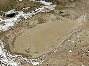
. - Lop Lake, in the Tarim BasinTarim BasinThe Tarim Basin is a large endorheic basin occupying an area of about . It is located in the Xinjiang Uyghur Autonomous Region in China's far west. Its northern boundary is the Tian Shan mountain range and its southern is the Kunlun Mountains on the northern edge of the Tibetan Plateau. The...
of China'sPeople's Republic of ChinaChina , officially the People's Republic of China , is the most populous country in the world, with over 1.3 billion citizens. Located in East Asia, the country covers approximately 9.6 million square kilometres...
Xinjiang Uygur Autonomous RegionXinjiangXinjiang is an autonomous region of the People's Republic of China. It is the largest Chinese administrative division and spans over 1.6 million km2...
. - The Central Asian Internal Drainage BasinCentral Asian Internal Drainage BasinThe Central Asian Inland Basin is the largest of 3 major hydrological basins that cover Mongolia ....
, in southern and western MongoliaMongoliaMongolia is a landlocked country in East and Central Asia. It is bordered by Russia to the north and China to the south, east and west. Although Mongolia does not share a border with Kazakhstan, its western-most point is only from Kazakhstan's eastern tip. Ulan Bator, the capital and largest...
, contains a series of closed drainage basins, such as the Khyargas NuurKhyargas NuurKhyargas Lake is a salt lake in Khyargas district, Uvs Province, Western Mongolia.Some sources are using different Khyargas Lake statistics values:*Water level: 1,035.29 m*Surface area: 1,481.1 km²*Average depth: 50.7 m*Volume: 75.2 km³....
basin, the Uvs Nuur basin, and the Pu-Lun-To River Basin. - Qaidam Basin, in QinghaiQinghaiQinghai ; Oirat Mongolian: ; ; Salar:) is a province of the People's Republic of China, named after Qinghai Lake...
Province, China. - Sistan BasinSistan BasinThe Sistan Basin is an inland endorheic basin encompassing large parts of southwestern Afghanistan and southeastern Iran, one of the driest regions in the world and an area subjected to prolonged droughts...
covering areas of IranIranIran , officially the Islamic Republic of Iran , is a country in Southern and Western Asia. The name "Iran" has been in use natively since the Sassanian era and came into use internationally in 1935, before which the country was known to the Western world as Persia...
and AfghanistanAfghanistanAfghanistan , officially the Islamic Republic of Afghanistan, is a landlocked country located in the centre of Asia, forming South Asia, Central Asia and the Middle East. With a population of about 29 million, it has an area of , making it the 42nd most populous and 41st largest nation in the world...
Other endorheic lakes and basins in Asia include:
- The Dead SeaDead SeaThe Dead Sea , also called the Salt Sea, is a salt lake bordering Jordan to the east and Israel and the West Bank to the west. Its surface and shores are below sea level, the lowest elevation on the Earth's surface. The Dead Sea is deep, the deepest hypersaline lake in the world...
, the lowest surface point on Earth and one of its saltiest bodies of water, lies between IsraelIsraelThe State of Israel is a parliamentary republic located in the Middle East, along the eastern shore of the Mediterranean Sea...
and JordanJordanJordan , officially the Hashemite Kingdom of Jordan , Al-Mamlaka al-Urduniyya al-Hashemiyya) is a kingdom on the East Bank of the River Jordan. The country borders Saudi Arabia to the east and south-east, Iraq to the north-east, Syria to the north and the West Bank and Israel to the west, sharing...
. - Sambhar Lake, in RajasthanRajasthanRājasthān the land of Rajasthanis, , is the largest state of the Republic of India by area. It is located in the northwest of India. It encompasses most of the area of the large, inhospitable Great Indian Desert , which has an edge paralleling the Sutlej-Indus river valley along its border with...
, north-western IndiaIndiaIndia , officially the Republic of India , is a country in South Asia. It is the seventh-largest country by geographical area, the second-most populous country with over 1.2 billion people, and the most populous democracy in the world...
, is also the terminal point of an endorheic basin. - Lake VanLake VanLake Van is the largest lake in Turkey, located in the far east of the country in Van district. It is a saline and soda lake, receiving water from numerous small streams that descend from the surrounding mountains. Lake Van is one of the world's largest endorheic lakes . The original outlet from...
, in TurkeyTurkeyTurkey , known officially as the Republic of Turkey , is a Eurasian country located in Western Asia and in East Thrace in Southeastern Europe...
, is one of the world's largest endorheic lakes. - Sabkhat al-JabbulSabkhat al-JabbulSabkhat al-Jabbūl or Mamlahat al-Jabbūl or Lake Jabbūl is a large, traditionally seasonal, saline lake and concurrent salt flats 30 km southeast of Aleppo, Syria, in the Bāb District of Aleppo Governorate. It is the largest natural lake in Syria and the second largest lake after the...
, extensive salt flats and a 100 square kilometres (38.6 sq mi) lake in SyriaSyriaSyria , officially the Syrian Arab Republic , is a country in Western Asia, bordering Lebanon and the Mediterranean Sea to the West, Turkey to the north, Iraq to the east, Jordan to the south, and Israel to the southwest....
. - Solar LakeSolar LakeSolar Lake is a saline desert lake located on the edge of the Red Sea, about 18 km south of Eilat in the Sinai Peninsula, Taba, Egypt, close to its borders with Israel...
, Sinai, near the IsraelIsraelThe State of Israel is a parliamentary republic located in the Middle East, along the eastern shore of the Mediterranean Sea...
i-EgyptEgyptEgypt , officially the Arab Republic of Egypt, Arabic: , is a country mainly in North Africa, with the Sinai Peninsula forming a land bridge in Southwest Asia. Egypt is thus a transcontinental country, and a major power in Africa, the Mediterranean Basin, the Middle East and the Muslim world...
border.
Australia
Australia
Australia , officially the Commonwealth of Australia, is a country in the Southern Hemisphere comprising the mainland of the Australian continent, the island of Tasmania, and numerous smaller islands in the Indian and Pacific Oceans. It is the world's sixth-largest country by total area...
, being very dry and having exceedingly low runoff ratios due to its ancient soils, has many endorheic drainages. The most important are:
- Lake Eyre BasinLake Eyre BasinThe Lake Eyre basin is a drainage basin that covers just under one-sixth of all Australia. The Lake Eyre Basin is the largest endorheic basin in Australia and amongst the largest in the world, covering about 1,200,000 square kilometres, including much of inland Queensland, large portions of South...
, which drains into the highly variable Lake EyreLake EyreLake Eyre is the lowest point in Australia, at approximately below sea level, and, on the rare occasions that it fills, it is the largest lake in Australia and 18th largest in the world...
and includes Lake FromeLake FromeLake Frome is a large endorheic lake in South Australia, east of the Northern Flinders Ranges. It is a large, shallow, unvegetated salt pan, 100 km long and 40 km wide, lying mostly below sea level and having a total surface area of 259,615 hectares...
. - Lake TorrensLake TorrensLake Torrens is a salt lake in central South Australia. It is located in the Lake Torrens National Park....
, to the west of the Flinders RangesFlinders RangesFlinders Ranges is the largest mountain range in South Australia, which starts approximately north west of Adelaide. The discontinuous ranges stretch for over from Port Pirie to Lake Callabonna...
in South AustraliaSouth AustraliaSouth Australia is a state of Australia in the southern central part of the country. It covers some of the most arid parts of the continent; with a total land area of , it is the fourth largest of Australia's six states and two territories.South Australia shares borders with all of the mainland...
. - Lake CorangamiteLake CorangamiteLake Corangamite is Victoria’s largest natural lake, located near Colac in south-west Victoria, Australia in the Lakes and Craters region of the Victorian Volcanic Plains. The lake is hypersaline, and salinity levels have increased dramatically as the lake level has dropped in recent decades...
, a highly saline crater lakeCrater lakeA crater lake is a lake that forms in a volcanic crater or caldera, such as a maar; less commonly and with lower association to the term a lake may form in an impact crater caused by a meteorite. Sometimes lakes which form inside calderas are called caldera lakes, but often this distinction is not...
in western VictoriaVictoria (Australia)Victoria is the second most populous state in Australia. Geographically the smallest mainland state, Victoria is bordered by New South Wales, South Australia, and Tasmania on Boundary Islet to the north, west and south respectively....
. - Lake George, formerly connected to the Murray-Darling BasinMurray-Darling BasinThe Murray-Darling basin is a large geographical area in the interior of southeastern Australia, whose name is derived from its two major rivers, the Murray River and the Darling River. It drains one-seventh of the Australian land mass, and is currently by far the most significant agricultural...
Africa
Large endorheic regions in Africa are located in the Sahara Desert, the Kalahari DesertKalahari Desert
The Kalahari Desert is a large semi-arid sandy savannah in Southern Africa extending , covering much of Botswana and parts of Namibia and South Africa, as semi-desert, with huge tracts of excellent grazing after good rains. The Kalahari supports more animals and plants than a true desert...
, and the Great Rift Valley
Great Rift Valley
The Great Rift Valley is a name given in the late 19th century by British explorer John Walter Gregory to the continuous geographic trench, approximately in length, that runs from northern Syria in Southwest Asia to central Mozambique in South East Africa...
:
- Chad BasinChad BasinThe Chad Basin, also known as the Lake Chad Basin, is a large lowland area in north-central Africa. In all directions from the center of this area the elevation changes are gentle. The Chad Basin is an endorheic basin - its water does not flow into any ocean...
, in the northern center of Africa. It covers an area of approximately 2.434 million km². - Qattara DepressionQattara DepressionThe Qattara Depression is a depression in the north west of Egypt in the Matruh Governorate and is part of the Libyan Desert. It lies below sea level and is covered with salt pans, sand dunes and salt marshes. The region extends between latitudes of 28°35' and 30°25' North and longitudes of 26°20'...
, in EgyptEgyptEgypt , officially the Arab Republic of Egypt, Arabic: , is a country mainly in North Africa, with the Sinai Peninsula forming a land bridge in Southwest Asia. Egypt is thus a transcontinental country, and a major power in Africa, the Mediterranean Basin, the Middle East and the Muslim world...
. - Chott MelrhirChott MelrhirChott Melrhir also known as Chott Melghir or Chott Melhir is an endorheic salt lake in northeastern Algeria. It the westernmost part of a series of depressions, which extend from the Gulf of Gabès into the Sahara. They were created between Miocene and Early Pleistocene as a result of compression...
, in AlgeriaAlgeriaAlgeria , officially the People's Democratic Republic of Algeria , also formally referred to as the Democratic and Popular Republic of Algeria, is a country in the Maghreb region of Northwest Africa with Algiers as its capital.In terms of land area, it is the largest country in Africa and the Arab...
. - Chott el DjeridChott el DjeridChott el Djerid , also spelt Shaţţ al Jarīd, Sciott Gerid, and Shott el Jerid, is a large endorheic salt lake in southern Tunisia.-Geography:The bottom of Chott el Djerid is located between 10 and 25 meters above sea level....
, in TunisiaTunisiaTunisia , officially the Tunisian RepublicThe long name of Tunisia in other languages used in the country is: , is the northernmost country in Africa. It is a Maghreb country and is bordered by Algeria to the west, Libya to the southeast, and the Mediterranean Sea to the north and east. Its area...
. - The Okavango RiverOkavango RiverThe Okavango River is a river in southwest Africa. It is the fourth-longest river system in southern Africa, running southeastward for . It begins in Angola, where it is known as the Cubango River...
, in the Kalahari Desert, is part of an endorheic basin region which also includes the Okavango DeltaOkavango DeltaThe Okavango Delta , in Botswana, is the world's largest inland delta. It is formed where the Okavango River empties onto a swamp in an endorheic basin in the Kalahari Desert, where most of the water is lost to evaporation and transpiration instead of draining into the sea...
, Lake NgamiLake NgamiLake Ngami is an endorheic lake in Botswana north of the Kalahari Desert. It is seasonally filled by the Taughe River an affluent of the Okavango River system flowing out of the western side of the Okavango Delta. It is one of the fragmented remnants of the ancient Lake Makgadikgadi...
, the Nata RiverNata RiverThe Nata River or Amanzanyama River is a natural watercourse in Southern Africa. Within the country of Botswana the Nata River is a source of water to the ephemeral wetlands of the Makgadikgadi Pans, where a number of species of limited distribution thrive...
, and a number of salt pans such as Makgadikgadi PanMakgadikgadi PanThe Makgadikgadi Pan is a large salt pan in the middle of the dry savanna of northeastern Botswana. It is one of the largest salt flats in the world...
. - Etosha pan in NamibiaNamibiaNamibia, officially the Republic of Namibia , is a country in southern Africa whose western border is the Atlantic Ocean. It shares land borders with Angola and Zambia to the north, Botswana to the east and South Africa to the south and east. It gained independence from South Africa on 21 March...
’s Etosha National ParkEtosha National ParkEtosha National Park is a national park in the Kunene Region of northwestern Namibia. The park shares boundaries with the regions of Oshana, Oshikoto and Otjozondjupa....
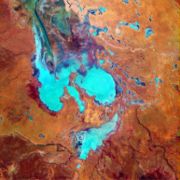
. - Lake TurkanaLake TurkanaLake Turkana , formerly known as Lake Rudolf, is a lake in the Great Rift Valley in Kenya, with its far northern end crossing into Ethiopia. It is the world's largest permanent desert lake and the world's largest alkaline lake...
, in KenyaKenyaKenya , officially known as the Republic of Kenya, is a country in East Africa that lies on the equator, with the Indian Ocean to its south-east...
, whose basin includes the Omo RiverOmo RiverThe Omo River is an important river of southern Ethiopia. Its course is entirely contained within the boundaries of Ethiopia, and empties into Lake Turkana on the border with Kenya...
of EthiopiaEthiopiaEthiopia , officially known as the Federal Democratic Republic of Ethiopia, is a country located in the Horn of Africa. It is the second-most populous nation in Africa, with over 82 million inhabitants, and the tenth-largest by area, occupying 1,100,000 km2...
. - Lake ChilwaLake ChilwaLake Chilwa is the second-largest lake in Malawi after Lake Malawi. It is in eastern Zomba District, near the border with Mozambique. Approximately 60 km long and 40 km wide, the lake is surrounded by extensive wetlands....
, in MalawiMalawiThe Republic of Malawi is a landlocked country in southeast Africa that was formerly known as Nyasaland. It is bordered by Zambia to the northwest, Tanzania to the northeast, and Mozambique on the east, south and west. The country is separated from Tanzania and Mozambique by Lake Malawi. Its size...
. - Afar DepressionAfar DepressionThe Afar Triangle is a geological depression that is caused by the Afar Triple Junction which is part of the Great Rift Valley. It overlaps Eritrea, Djibouti and the entire Afar Region of Ethiopia. The Afar Triangle includes the Danakil Depression and the lowest point in Africa, Lake Asal...
, in EritreaEritreaEritrea , officially the State of Eritrea, is a country in the Horn of Africa. Eritrea derives it's name from the Greek word Erethria, meaning 'red land'. The capital is Asmara. It is bordered by Sudan in the west, Ethiopia in the south, and Djibouti in the southeast...
, EthiopiaEthiopiaEthiopia , officially known as the Federal Democratic Republic of Ethiopia, is a country located in the Horn of Africa. It is the second-most populous nation in Africa, with over 82 million inhabitants, and the tenth-largest by area, occupying 1,100,000 km2...
, and DjiboutiDjiboutiDjibouti , officially the Republic of Djibouti , is a country in the Horn of Africa. It is bordered by Eritrea in the north, Ethiopia in the west and south, and Somalia in the southeast. The remainder of the border is formed by the Red Sea and the Gulf of Aden at the east...
. - Some Rift Valley lakesRift Valley lakesThe Rift Valley lakes are a group of lakes in the Great Rift Valley formed by the East African Rift which runs through the whole eastern side of the African continent from north to south...
, such as Lake AbijattaLake AbijattaLake Abijata lies in Ethiopia south of Addis Ababa, in the Abijatta-Shalla National Park. According to the Statistical Abstract of Ethiopia for 1967/68, the lake is 17 kilometers long and 15 km wide, with a surface area of 205 square kilometers...
, Lake Chew BahirLake Chew BahirLake Chew Bahir or Lake Istifanos, also called Stefanie, Basso Naebor and Chuwaha, is a lake in Southern Ethiopia on the boundary between the Oromia and the Southern Nations, Nationalities and Peoples' Regions. When the lake is filled, it stretches into northern Kenya...
, Lake ShalaLake ShalaLake Shala lies in Ethiopia south of Addis Ababa, in the Abijatta-Shalla National Park. The lake is 28 kilometers long and 12 wide, with a surface area of 329 square kilometers. It has a maximum depth of 266 meters and is at an elevation of 1,558 meters...
, Lake ChamoLake ChamoLake Chamo is a lake in the Southern Nations, Nationalities, and Peoples Region of southern Ethiopia. It is located in the Great Rift Valley at an elevation of 1,110 meters. It is just to the south of Lake Abaya and the city of Arba Minch, and east of the Guge Mountains.The lake's northern end...
, and Lake AwasaLake AwasaLake Awasa is an endorheic basin in Ethiopia, located in the Rift Valley south of Addis Ababa. According to the Statistical Abstract of Ethiopia for 1967/68, the lake is 16 km long and 9 km wide, with a surface area of 129 square kilometers...
. - Lake Mweru WantipaLake Mweru WantipaLake Mweru Wantipa is a lake and swamp system in the Northern Province of Zambia. It has been regarded in the past as something of mystery, displaying fluctuations in water level and salinity which were not entirely explained by variation in rainfall levels; it has been known to dry out almost...
, in ZambiaZambiaZambia , officially the Republic of Zambia, is a landlocked country in Southern Africa. The neighbouring countries are the Democratic Republic of the Congo to the north, Tanzania to the north-east, Malawi to the east, Mozambique, Zimbabwe, Botswana and Namibia to the south, and Angola to the west....
.
North and Central America
- The Valley of MexicoValley of MexicoThe Valley of Mexico is a highlands plateau in central Mexico roughly coterminous with the present-day Distrito Federal and the eastern half of the State of Mexico. Surrounded by mountains and volcanoes, the Valley of Mexico was a centre for several pre-Columbian civilizations, including...
. In Pre-ColumbianPre-ColumbianThe pre-Columbian era incorporates all period subdivisions in the history and prehistory of the Americas before the appearance of significant European influences on the American continents, spanning the time of the original settlement in the Upper Paleolithic period to European colonization during...
times, the Valley was substantially covered with five lakes, including Lake TexcocoLake TexcocoLake Texcoco was a natural lake formation within the Valley of Mexico. The Aztecs built the city of Tenochtitlan on an island in the lake. The Spaniards built Mexico City over Tenochtitlan...
, Lake XochimilcoLake XochimilcoLake Xochimilco is an ancient endorheic lake located in the Valley of Mexico, part of a series of lakes, which included the brackish Lake Texcoco, Lake Zumpango, and Lake Xaltocan and the fresh water Lake Chalco...
, and Lake ChalcoLake ChalcoLake Chalco was an endorheic lake formerly located in the Valley of Mexico and was important for human development in central Mexico. The lake was named after the city of Chalco on its eastern shore....
. - Guzmán BasinGuzmán BasinThe Guzmán Basin is an endorheic basin of northern Mexico and the southwestern United States. It occupies the northwestern portion of Chihuahua in Mexico, and extends into southwestern New Mexico in the United States....
, in northern Mexico and the southwestern United States. - Lago de AtitlánLago de AtitlánLake Atitlán is a large endorheic lake in the Guatemalan Highlands. Atitlan is recognized to be the deepest lake in Central America with maximum depth about 340 meters. The lake is shaped by deep escarpments which surround it and by three volcanos on its southern flank...
, in the highlands of Guatemala. - Bolsón de MapimíBolsón de MapimíThe Bolsón de Mapimí is an endorheic river basin located in the center-north of the Mexican Plateau.It is also known as the Comarca Lagunera, and is shared by the states of Durango, Coahuila, Chihuahua, and Zacatecas...
, in northern MexicoMexicoThe United Mexican States , commonly known as Mexico , is a federal constitutional republic in North America. It is bordered on the north by the United States; on the south and west by the Pacific Ocean; on the southeast by Guatemala, Belize, and the Caribbean Sea; and on the east by the Gulf of...
. - The Great BasinGreat BasinThe Great Basin is the largest area of contiguous endorheic watersheds in North America and is noted for its arid conditions and Basin and Range topography that varies from the North American low point at Badwater Basin to the highest point of the contiguous United States, less than away at the...
, which covers much of NevadaNevadaNevada is a state in the western, mountain west, and southwestern regions of the United States. With an area of and a population of about 2.7 million, it is the 7th-largest and 35th-most populous state. Over two-thirds of Nevada's people live in the Las Vegas metropolitan area, which contains its...
and UtahUtahUtah is a state in the Western United States. It was the 45th state to join the Union, on January 4, 1896. Approximately 80% of Utah's 2,763,885 people live along the Wasatch Front, centering on Salt Lake City. This leaves vast expanses of the state nearly uninhabited, making the population the...
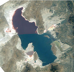
, is a large region of contiguous closed basins, including:- Great Salt LakeGreat Salt LakeThe Great Salt Lake, located in the northern part of the U.S. state of Utah, is the largest salt water lake in the western hemisphere, the fourth-largest terminal lake in the world. In an average year the lake covers an area of around , but the lake's size fluctuates substantially due to its...
, in Utah, the largest terminal lake in the Western HemisphereWestern HemisphereThe Western Hemisphere or western hemisphere is mainly used as a geographical term for the half of the Earth that lies west of the Prime Meridian and east of the Antimeridian , the other half being called the Eastern Hemisphere.In this sense, the western hemisphere consists of the western portions...
. - The Black Rock DesertBlack Rock DesertThe Black Rock Desert is an arid region in the northern Nevada section of the Great Basin with a lakebed that is a dry remnant of Pleistocene Lake Lahontan...
in NevadaNevadaNevada is a state in the western, mountain west, and southwestern regions of the United States. With an area of and a population of about 2.7 million, it is the 7th-largest and 35th-most populous state. Over two-thirds of Nevada's people live in the Las Vegas metropolitan area, which contains its...
, location of the Thrust2Thrust2Thrust2 is a British designed and built jet propelled car, which held the world land speed record from 4 October 1983 to 25 September 1997.The car was designed by John Ackroyd and driven by Richard Noble. On October 4, 1983 the car reached a top speed of and broke the record at . This was...
and ThrustSSCThrustSSCThrustSSC, also spelt Thrust SSC by secondary sources, is a British jet-propelled car developed by Richard Noble, Glynne Bowsher, Ron Ayers and Jeremy Bliss....
landspeed record runs, and the annual home to the Burning ManBurning ManBurning Man is a week-long annual event held in the Black Rock Desert in northern Nevada, in the United States. The event starts on the Monday before the American Labor Day holiday, and ends on the holiday itself. It takes its name from the ritual burning of a large wooden effigy on Saturday evening...
festival. - Death ValleyDeath ValleyDeath Valley is a desert valley located in Eastern California. Situated within the Mojave Desert, it features the lowest, driest, and hottest locations in North America. Badwater, a basin located in Death Valley, is the specific location of the lowest elevation in North America at 282 feet below...
, the lowest land point in the United States. During the HoloceneHoloceneThe Holocene is a geological epoch which began at the end of the Pleistocene and continues to the present. The Holocene is part of the Quaternary period. Its name comes from the Greek words and , meaning "entirely recent"...
epochEpoch (geology)An epoch is a subdivision of the geologic timescale based on rock layering. In order, the higher subdivisions are periods, eras and eons. We are currently living in the Holocene epoch...
, Lake ManlyLake ManlyLake Manly is a pluvial, former freshwater, endorheic, rift lake that filled the Death Valley basin of Inyo County, California through the Holocene before the area's climate changed to desert. Following its isolation from the Colorado River system, Lake Manly receded by evaporation with Badwater...
filled the Death Valley basin of Inyo County, California. Later, Death Valley had a system of tributary basins:- Rogers Dry LakeRogers Dry LakeRogers Dry Lake is an endorheic desert salt pan in the Mojave Desert of Kern County, California. The lake derives its name from the Anglicization from the Spanish name, Rodriguez Dry Lake. It is the central part of Edwards Air Force Base as its hard surface provides a natural extension to the...
, at Edwards Air Force BaseEdwards Air Force BaseEdwards Air Force Base is a United States Air Force base located on the border of Kern County, Los Angeles County, and San Bernardino County, California, in the Antelope Valley. It is southwest of the central business district of North Edwards, California and due east of Rosamond.It is named in...
in California. - Owens LakeOwens LakeOwens Lake is a mostly dry lake in the Owens Valley on the eastern side of the Sierra Nevada in Inyo County, California. It is located about south of Lone Pine, California...
and the Owens RiverOwens RiverThe Owens River is a river in southeastern California in the United States, approximately long. It drains into and through the Owens Valley, an arid basin between the eastern slope of the Sierra Nevada and the western faces of the Inyo and White Mountains. The river terminates at Owens Lake, but...
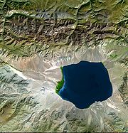
basin.- Mono LakeMono LakeMono Lake is a large, shallow saline lake in Mono County, California, formed at least 760,000 years ago as a terminal lake in a basin that has no outlet to the ocean...
in CaliforniaCaliforniaCalifornia is a state located on the West Coast of the United States. It is by far the most populous U.S. state, and the third-largest by land area...
.
- Mono Lake
- Rogers Dry Lake
- Groom Dry Lake in Nevada, location of Area 51Area 51Area 51 is a military base, and a remote detachment of Edwards Air Force Base. It is located in the southern portion of Nevada in the western United States, 83 miles north-northwest of downtown Las Vegas. Situated at its center, on the southern shore of Groom Lake, is a large military airfield...
. - Salton SeaSalton SeaThe Salton Sea is a shallow, saline, endorheic rift lake located directly on the San Andreas Fault, predominantly in California's Imperial Valley. The lake occupies the lowest elevations of the Salton Sink in the Colorado Desert of Imperial and Riverside counties in Southern California. Like Death...
in CaliforniaCaliforniaCalifornia is a state located on the West Coast of the United States. It is by far the most populous U.S. state, and the third-largest by land area...
, a lake accidentally recreated in 1905 when irrigation canalsAlamo CanalThe Alamo Canal was a long waterway that connected the Colorado River to the head of the Alamo River. The canal was constructed to provide irrigation to the Imperial Valley. A small portion of the canal was located in the United States but the majority of the canal was located in Mexico...
ruptured, filling a desert endorheic basinSalton SinkThe Salton Sink is a geographic sink in the Coachella and Imperial valleys of southeastern California. It is in the Colorado Desert subregion of the Sonoran Desert ecoregion...
and recreating an ancient saline seaLake CahuillaPrehistoric Lake Cahuilla was an extensive freshwater lake that filled the Coachella, Imperial, and Mexicali valleys of southeastern California and northeastern Baja California during the centuries prior to Spanish entry into the region...
. - Sevier LakeSevier LakeSevier Lake is an intermittent and endorheic lake which lies in the lowest part of the Sevier Desert, Millard County, Utah. Like Great Salt Lake and Utah Lake, it is a remnant of Pleistocene Lake Bonneville. Sevier Lake is fed primarily by the Beaver and Sevier rivers, and the additional inflow...
, in Utah. - Pyramid Lake in Nevada, whose drainage basin includes Lake TahoeLake TahoeLake Tahoe is a large freshwater lake in the Sierra Nevada of the United States. At a surface elevation of , it is located along the border between California and Nevada, west of Carson City. Lake Tahoe is the largest alpine lake in North America. Its depth is , making it the USA's second-deepest...
. - Humboldt SinkHumboldt SinkHumboldt Sink is an intermittent dry lake bed, approximately 11 mi long, and 4 mi across, in northwestern Nevada in the United States...
and the Humboldt RiverHumboldt RiverThe Humboldt River runs through northern Nevada in the western United States. At approximately long it is the second longest river in the Great Basin, after the Bear River. It has no outlet to the ocean, but instead empties into the Humboldt Sink...
basin in Nevada. - Carson SinkCarson SinkCarson Sink is a playa in the northeastern portion of the Carson Desert that was formerly the terminus of the Carson River. The sink is currently fed by drainage canals of the Truckee-Carson Irrigation District...
and the Carson RiverCarson RiverThe Carson River is a northwestern Nevada river that empties into the Carson Sink, an endorheic basin. The main stem of the river is long....
basin in Nevada. - Walker LakeWalker Lake (Nevada)Walker Lake is a natural lake, 50.3 mi² in area, in the Great Basin in western Nevada in the United States. It is 18 mi long and 7 mi wide, located in northwestern Mineral County along the eastern side of the Wassuk Range, approximately 75 mi southeast of Reno...
and the Walker River in Nevada.
- Great Salt Lake
- Tulare LakeTulare LakeTulare Lake, named Laguna de Tache by the Spanish, is a fresh-water dry lake with residual wetlands and marshes in southern San Joaquin Valley, California...
at the southern end of the San Joaquin ValleySan Joaquin ValleyThe San Joaquin Valley is the area of the Central Valley of California that lies south of the Sacramento – San Joaquin River Delta in Stockton...
fed by the KaweahKaweah RiverThe Kaweah River in the U.S. state of California flows westward from the foothills of the Sierra Nevada into the Central Valley. It rises in forks in the southern Sierra Nevada inside Sequoia National Park, the longest of which is the Middle Fork, about long...
, KernKern RiverThe Kern River is a river in the U.S. state of California, approximately long. It drains an area of the southern Sierra Nevada mountains northeast of Bakersfield. Fed by snowmelt near Mount Whitney, the river passes through scenic canyons in the mountains and is a popular destination for...
and Tule RiverTule RiverThe Tule River, also called Rio de San Pedro or Rio San Pedro, is a river in Tulare County in the U.S. state of California. The river originates in the Sierra Nevada east of Porterville and consists of three forks, North, Middle and South. The North Fork and Middle Fork meet above Springville. The...
s plus southern distributaries of the KingsKings River (California)The Kings River is a major river of south-central California. About long, it drains an area of the high western Sierra Nevada and the Central Valley. A large alluvial fan has formed where the river's gradient decreases in the Central Valley so the river divides into distributaries...
; however, agricultural development and irrigation diversions have left the lake dry. - Crater LakeCrater LakeCrater Lake is a caldera lake located in the south-central region of the U.S. state of Oregon. It is the main feature of Crater Lake National Park and famous for its deep blue color and water clarity. The lake partly fills a nearly deep caldera that was formed around 7,700 years agoby the...
, in OregonOregonOregon is a state in the Pacific Northwest region of the United States. It is located on the Pacific coast, with Washington to the north, California to the south, Nevada on the southeast and Idaho to the east. The Columbia and Snake rivers delineate much of Oregon's northern and eastern...
. - The Great Divide BasinGreat Divide BasinThe Great Divide Basin is a drainage basin of the Continental Divide of the Americas. The basin is between the Green River watershed on the west and the Medicine Bow River watershed on the east . From the northwest, the basin begins in the "Wind River Range .....
in WyomingWyomingWyoming is a state in the mountain region of the Western United States. The western two thirds of the state is covered mostly with the mountain ranges and rangelands in the foothills of the Eastern Rocky Mountains, while the eastern third of the state is high elevation prairie known as the High...
, a small endorheic basin that straddles the Continental Divide of the Americas. - Devils Lake, in North DakotaNorth DakotaNorth Dakota is a state located in the Midwestern region of the United States of America, along the Canadian border. The state is bordered by Canada to the north, Minnesota to the east, South Dakota to the south and Montana to the west. North Dakota is the 19th-largest state by area in the U.S....
. - Devil's LakeDevil's Lake (Wisconsin)Devil's Lake is an endorheic lake in the South Range of the Baraboo Hills, about two miles south of Baraboo, Wisconsin, in Sauk County, Wisconsin, USA. The lake is one of the primary attractions of the eponymous Devil's Lake State Park....
, in WisconsinWisconsinWisconsin is a U.S. state located in the north-central United States and is part of the Midwest. It is bordered by Minnesota to the west, Iowa to the southwest, Illinois to the south, Lake Michigan to the east, Michigan to the northeast, and Lake Superior to the north. Wisconsin's capital is...
. - Little Manitou LakeLittle Manitou Lake (Saskatchewan)Little Manitou Lake is a small saltwater lake about 100 kilometres South-East of Saskatoon. The lake was formed by receding glaciers during the most recent ice age. It is fed by underground springs, and has a mineral content high in sodium, magnesium and potassium salts due to it being a terminal...
in SaskatchewanSaskatchewanSaskatchewan is a prairie province in Canada, which has an area of . Saskatchewan is bordered on the west by Alberta, on the north by the Northwest Territories, on the east by Manitoba, and on the south by the U.S. states of Montana and North Dakota....
. - Old Wives LakeOld Wives LakeOld Wives Lake is a shallow saline lake in south central Saskatchewan, Canada, about 30 km southwest of Moose Jaw. The lake is fed by the Wood River but seasonal water relatively flattened the terrain, and as such results in significant mudflats. A Migratory Bird Sanctuary was established at the...
, on the Laurentian DivideLaurentian DivideThe Laurentian Divide or Northern Divide is a continental divide dividing the direction of water flow in eastern and southern Canada and the northern Midwestern United States. Water north of the height of land flows to the Arctic Ocean by rivers to Hudson Bay or directly to the Arctic...
in Saskatchewan. - Pakowki LakePakowki LakePakowki Lake is an endorheic lake in Alberta, Canada located south of Etzikom, Alberta and not far north is the former town site of Pakowki which may have received it's name from the lake....
, on the Laurentian DivideLaurentian DivideThe Laurentian Divide or Northern Divide is a continental divide dividing the direction of water flow in eastern and southern Canada and the northern Midwestern United States. Water north of the height of land flows to the Arctic Ocean by rivers to Hudson Bay or directly to the Arctic...
in AlbertaAlbertaAlberta is a province of Canada. It had an estimated population of 3.7 million in 2010 making it the most populous of Canada's three prairie provinces...
.
- New MexicoNew MexicoNew Mexico is a state located in the southwest and western regions of the United States. New Mexico is also usually considered one of the Mountain States. With a population density of 16 per square mile, New Mexico is the sixth-most sparsely inhabited U.S...
has a number of desert endorheic basins including:- The Tularosa BasinTularosa BasinThe Tularosa Basin is a graben basin in the Basin and Range Province and within the Chihuahuan Desert, east of the Rio Grande in southern New Mexico, in the Southwestern United States.-Geography:...
, a rift valleyRift valleyA rift valley is a linear-shaped lowland between highlands or mountain ranges created by the action of a geologic rift or fault. This action is manifest as crustal extension, a spreading apart of the surface which is subsequently further deepened by the forces of erosion...
. - Zuni Salt LakeZuni Salt LakeZuni Salt Lake, also Zuñi Salt Lake , is a rare high desert lake, and a classic maar. It is located in Catron County, about 60 miles south of the Zuni Pueblo, New Mexico, USA. Zuñi Salt Lake is extremely shallow, with the depth only to four feet in the wet season. During the dry season, much of...
, a maarMaarA maar is a broad, low-relief volcanic crater that is caused by a phreatomagmatic eruption, an explosion caused by groundwater coming into contact with hot lava or magma. A maar characteristically fills with water to form a relatively shallow crater lake. The name comes from the local Moselle...
. - The Mimbres RiverMimbres RiverThe Mimbres River is a river in southwestern New Mexico. It forms from snow pack and runoff on the south-western slopes of the Black Range and flows into a small endorheic basin east of Deming, New Mexico. The uplands watershed are administered by the US Forest Service, while the land in the...
Basin, in Grant County.
- The Tularosa Basin
Many small lakes and ponds in North Dakota
North Dakota
North Dakota is a state located in the Midwestern region of the United States of America, along the Canadian border. The state is bordered by Canada to the north, Minnesota to the east, South Dakota to the south and Montana to the west. North Dakota is the 19th-largest state by area in the U.S....
and Manitoba
Manitoba
Manitoba is a Canadian prairie province with an area of . The province has over 110,000 lakes and has a largely continental climate because of its flat topography. Agriculture, mostly concentrated in the fertile southern and western parts of the province, is vital to the province's economy; other...
are endorheic; some of them have salt encrustations along their shores.
Europe
- Lake Neusiedl, in AustriaAustriaAustria , officially the Republic of Austria , is a landlocked country of roughly 8.4 million people in Central Europe. It is bordered by the Czech Republic and Germany to the north, Slovakia and Hungary to the east, Slovenia and Italy to the south, and Switzerland and Liechtenstein to the...
and HungaryHungaryHungary , officially the Republic of Hungary , is a landlocked country in Central Europe. It is situated in the Carpathian Basin and is bordered by Slovakia to the north, Ukraine and Romania to the east, Serbia and Croatia to the south, Slovenia to the southwest and Austria to the west. The...
. - Lake TrasimenoLake TrasimenoLake Trasimeno , also referred to as Trasimene or Thrasimene in English, is the largest lake on the Italian peninsula south of the Po River with a surface area of 128 km2, slightly less than Lake Como...
, in ItalyItalyItaly , officially the Italian Republic languages]] under the European Charter for Regional or Minority Languages. In each of these, Italy's official name is as follows:;;;;;;;;), is a unitary parliamentary republic in South-Central Europe. To the north it borders France, Switzerland, Austria and...
. - Lake VelenceLake VelenceLake Velence is the third largest lake in Hungary. It is a popular holiday destination among Hungarians.The lake has an area of 26 km2., one third of which is covered by the common reed...
, in Hungary. - Lake PrespaLake PrespaPrespa is the name of two freshwater lakes in southeast Europe, shared by Greece, Albania, and Macedonia. Of the total surface area, belongs to Macedonia, to Greece and to Albania...
, between AlbaniaAlbaniaAlbania , officially known as the Republic of Albania , is a country in Southeastern Europe, in the Balkans region. It is bordered by Montenegro to the northwest, Kosovo to the northeast, the Republic of Macedonia to the east and Greece to the south and southeast. It has a coast on the Adriatic Sea...
, GreeceGreeceGreece , officially the Hellenic Republic , and historically Hellas or the Republic of Greece in English, is a country in southeastern Europe....
and the Republic of MacedoniaRepublic of MacedoniaMacedonia , officially the Republic of Macedonia , is a country located in the central Balkan peninsula in Southeast Europe. It is one of the successor states of the former Yugoslavia, from which it declared independence in 1991...
. - Rahasane turloughRahasane turloughRahasane turlough is a turlough, that is a karst lake, which has no surface outlet and is surrounded on all sides by rising land. It is the largest surviving turlough in Ireland. Water collects seasonally in the basin and drains away only through evaporation or seepage into the underlying limestone...
, the largest turloughTurlough (lake)A turlough, or turlach, is a unique type of disappearing lake found mostly in limestone areas of Ireland, west of the River Shannon. The name comes from the Irish "tuar", meaning dry, with the suffix "lach", meaning a place . The "lach" suffix is often mistakenly spelled and/or thought to refer to...
in IrelandRepublic of IrelandIreland , described as the Republic of Ireland , is a sovereign state in Europe occupying approximately five-sixths of the island of the same name. Its capital is Dublin. Ireland, which had a population of 4.58 million in 2011, is a constitutional republic governed as a parliamentary democracy,...
. - Laacher SeeLaacher See' or Laach Lake is a caldera lake and a potentially active volcano, in Rhineland-Palatinate, Germany, situated close to the cities of Koblenz , and Bonn , and closest to the towns Andernach , and Mayen . The caldera lake lies just 8 km from the river Rhine at Andernach...
, in Germany.
All these lakes are drained, however, either through manmade canal
Canal
Canals are man-made channels for water. There are two types of canal:#Waterways: navigable transportation canals used for carrying ships and boats shipping goods and conveying people, further subdivided into two kinds:...
s or via karstic phenomena. Minor additional endorheic lakes exist throughout the Mediterranean countries Spain
Spain
Spain , officially the Kingdom of Spain languages]] under the European Charter for Regional or Minority Languages. In each of these, Spain's official name is as follows:;;;;;;), is a country and member state of the European Union located in southwestern Europe on the Iberian Peninsula...
(e.g. Laguna de Gallocanta
Laguna de Gallocanta
The Gallocanta Lake is an endorheic lake located just to the south of Gallocanta village, between the Aragonese comarcas of Campo de Daroca and Comarca del Jiloca, Aragon, Spain...
), Italy
Italy
Italy , officially the Italian Republic languages]] under the European Charter for Regional or Minority Languages. In each of these, Italy's official name is as follows:;;;;;;;;), is a unitary parliamentary republic in South-Central Europe. To the north it borders France, Switzerland, Austria and...
, Cyprus
Cyprus
Cyprus , officially the Republic of Cyprus , is a Eurasian island country, member of the European Union, in the Eastern Mediterranean, east of Greece, south of Turkey, west of Syria and north of Egypt. It is the third largest island in the Mediterranean Sea.The earliest known human activity on the...
(Larnaca
Larnaca Salt Lake
Larnaca Salt Lake to the west of the town of Larnaca. It is a complex network of four salt lakes of different sizes. The largest is lake Aliki followed by lake Orphani, lake Soros and lake Spiro. They form the second largest salt lake in Cyprus after the Limassol Salt Lake...
and Akrotiri
Limassol Salt Lake
Limassol Salt Lake is the largest inland body of water on the island of Cyprus.It lies due south-east of the sprawling city of Limassol and measures 10.65 km². Its lowest point is 2.7 meters below sea level and at its deepest point the water depth measures about one meter...
salt lakes) and Greece
Greece
Greece , officially the Hellenic Republic , and historically Hellas or the Republic of Greece in English, is a country in southeastern Europe....
.
South America
- Laguna del CarbónLaguna del CarbónLaguna del Carbón is an endorheic salt lake in the Gran Bajo de San Julián of Santa Cruz Province, Argentina, 54 km from Puerto San Julián...
, in Gran Bajo de San Julián, ArgentinaArgentinaArgentina , officially the Argentine Republic , is the second largest country in South America by land area, after Brazil. It is constituted as a federation of 23 provinces and an autonomous city, Buenos Aires...
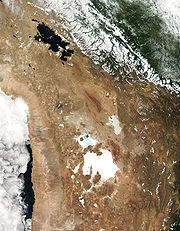
- the lowest point in the Western and Southern hemispheres - The AltiplanoAltiplanoThe Altiplano , in west-central South America, where the Andes are at their widest, is the most extensive area of high plateau on Earth outside of Tibet...
includes a number of closed basins such as Poopó Lake. - Lake ValenciaLake ValenciaLake Valencia is the third largest lake in Venezuela, exceeded in size only by Lake Maracaibo and Lake Guri. It occupies one of the so-called Aragua valleys, enclosed between the parallel mountain ranges of the Cordillera de la Costa, the Maritime Andes. One part is within the limits of Carabobo...
, in Venezuela. - Salar de AtacamaSalar de AtacamaSalar de Atacama is the largest salt flat in Chile. It is located south of San Pedro de Atacama, is surrounded by mountains and has no drainage outlets. To the east is enclosed by the main chain of the Andes, while to the west lies a secondary mountain range of the Andes called Cordillera de Domeyko...
, in the Atacama DesertAtacama DesertThe Atacama Desert is a plateau in South America, covering a strip of land on the Pacific coast, west of the Andes mountains. It is, according to NASA, National Geographic and many other publications, the driest desert in the world...
, ChileChileChile ,officially the Republic of Chile , is a country in South America occupying a long, narrow coastal strip between the Andes mountains to the east and the Pacific Ocean to the west. It borders Peru to the north, Bolivia to the northeast, Argentina to the east, and the Drake Passage in the far...
.
Ancient
Some of the Earth’s ancient endorheic systems include:- The Black SeaBlack SeaThe Black Sea is bounded by Europe, Anatolia and the Caucasus and is ultimately connected to the Atlantic Ocean via the Mediterranean and the Aegean seas and various straits. The Bosphorus strait connects it to the Sea of Marmara, and the strait of the Dardanelles connects that sea to the Aegean...
, until its merger with the Mediterranean. - The Mediterranean SeaMediterranean SeaThe Mediterranean Sea is a sea connected to the Atlantic Ocean surrounded by the Mediterranean region and almost completely enclosed by land: on the north by Anatolia and Europe, on the south by North Africa, and on the east by the Levant...
itself and all its tributary basins, during its Messinian desiccationMessinian salinity crisisThe Messinian Salinity Crisis, also referred to as the Messinian Event, and in its latest stage as the Lago Mare event, was a geological event during which the Mediterranean Sea went into a cycle of partly or nearly complete desiccation throughout the latter part of the Messinian age of the Miocene...
(5 m.y. BP approx.) as it became disconnected from the Atlantic Ocean. - Lake LahontanLake LahontanLake Lahontan was a large endorheic Pleistocene lake of modern northwestern Nevada that extended into northeastern California and southern Oregon...
in North America. - Lake BonnevilleLake BonnevilleLake Bonneville was a prehistoric pluvial lake that covered much of North America's Great Basin region. Most of the territory it covered was in present-day Utah, though parts of the lake extended into present-day Idaho and Nevada. Formed about 32,000 years ago, it existed until about 14,500 years...
in North America. - EbroEbroThe Ebro or Ebre is one of the most important rivers in the Iberian Peninsula. It is the biggest river by discharge volume in Spain.The Ebro flows through the following cities:*Reinosa in Cantabria.*Miranda de Ebro in Castile and León....
and Duero basins, draining most of northern Spain during the NeogeneNeogeneThe Neogene is a geologic period and system in the International Commission on Stratigraphy Geologic Timescale starting 23.03 ± 0.05 million years ago and ending 2.588 million years ago...
and perhaps PliocenePlioceneThe Pliocene Epoch is the period in the geologic timescale that extends from 5.332 million to 2.588 million years before present. It is the second and youngest epoch of the Neogene Period in the Cenozoic Era. The Pliocene follows the Miocene Epoch and is followed by the Pleistocene Epoch...
.