

Grand Teton National Park
Encyclopedia
Grand Teton National Park is a United States National Park located in northwestern Wyoming
, U.S.
The Park consists of approximately 310000 acres (125,452.7 ha) and includes the major peaks of the 40 miles (64.4 km) long Teton Range
as well as most of the northern sections of the valley known as Jackson Hole
. Only 10 miles (16.1 km) south of Yellowstone National Park
, the two parks are connected by the National Park Service
managed John D. Rockefeller, Jr. Memorial Parkway
. These three protected areas in conjunction with surrounding National Forests
constitute the Greater Yellowstone Ecosystem
, which at almost 18000000 acres (7,284,348 ha), is one of the largest intact mid-latitude temperate ecosystems in the world.
Human history of the Grand Teton region dates back at least 11,000 years, when the first nomadic hunter-gatherer
Paleo-Indians would migrate into the region during warmer months in pursuit of food and supplies. In the early 19th century, the first caucasian
explorers encountered the eastern Shoshone natives
. Between 1810 and 1840, the region attracted various fur trading companies which vied for control of the lucrative beaver fur. Organized U.S. Government explorations to the region commenced in the 1870s as an offshoot of exploration in Yellowstone. The first permanent settlers in Jackson Hole arrived in the 1880s. Efforts to preserve the region as a national park commenced in the late 19th century and by 1929, Grand Teton National Park was established, protecting the major peaks of the Teton Range. The valley of Jackson Hole remained in private ownership until conservationists led by John D. Rockefeller, Jr.
in the 1930s began purchasing land in Jackson Hole to be added to the existing national park. Against public opinion and with repeated congressional
efforts to repeal it, much of Jackson Hole was also set aside for protection as Jackson Hole National Monument
in 1943. In 1950 the monument was abolished and most of the monument acreage was added to Grand Teton National Park.
Grand Teton National Park is named for Grand Teton
which is the tallest mountain in the Teton Range. At 13775 feet (4,198.6 m), Grand Teton rises abruptly more than 7000 feet (2,133.6 m) above Jackson Hole and is almost 850 feet (259.1 m) higher than Mount Owen
, the second highest summit in the range.
, fire pits, tools and what are believed to have been fishing weights have been discovered. One of the tools is similar to those associated with the Clovis culture
which is believed to have existed approximately 11,500 years ago. Some of the tools are made of obsidian
which chemical analysis indicates was from sources near present day Teton Pass
which is south of where Grand Teton National Park is located. Though obsidian was also available north of Jackson Hole, virtually all the obsidian spear points found are from a source to the south, indicating that the main seasonal migratory route for the Paleo-Indian and later cultures was from the south. Elk
, which winter on the National Elk Refuge
at the southern end of Jackson Hole and head north into higher altitudes during spring and summer, follow a similar migratory pattern to this day. From 11,000 to about 500 years ago, there is little evidence of change in the migratory patterns amongst the Native American
groups in the region and no evidence that indicates any permanent human settlement.
When White American explorers first entered the region in the first decade of the 19th century, they encountered the eastern tribes of the Shoshone people. Most of the Shoshone that lived in the mountain vastness of the greater Yellowstone region continued to be pedestrian while other groups of Shoshone that resided in lower elevations had limited use of horse
s. The Shoshone that lived in the Jackson Hole region were known within their culture as the "Sheep-eaters" or "Tukudika" as they referred to themselves since a main staple of their diet was the Bighorn Sheep
. The Shoshones of the region continued to follow the same migratory pattern of their predecessors and have been documented as having a close spiritual relationship with the Teton Range. A number of stone enclosures on some of the peaks, including on the upper slopes of Grand Teton (known simply as The Enclosure) are believed to have been used by Shoshone during vision quest
s. In 1868, the mountain dwelling Shoshone were relocated to the Wind River Indian Reservation
east of the Wind River Range
in Wyoming.
(1804–1806) passed well north of the Grand Teton region. During the expedition's return trip from the Pacific Ocean
, expedition member John Colter
was given an early discharge so he could join two fur
trappers who were heading west in search of beaver pelts. Colter was later hired by Manuel Lisa
to lead fur trappers and to explore the region around the Yellowstone River
. It is generally believed that during the winter of 1807/08 Colter passed through Jackson Hole and was the first caucasian to see the Teton Range. In 1810, Lewis and Clark expedition coleader William Clark produced a map of the previous expedition as well as travels made by John Colter in 1807, apparently based on discussions between Clark and Colter when the two met in St. Louis, Missouri
in 1810. Another map attributed to William Clark indicates John Colter entered Jackson Hole from the northeast, crossing the Continental Divide at either Togwotee Pass
or Union Pass
and left the region after crossing Teton Pass, probably following the well established Native American trails. In 1931, the Colter Stone, a carved rock in the shape of a head with the inscription "John Colter" on one side and the year "1808" on the other, was discovered in a field in Tetonia, Idaho
, which is west of Teton Pass. The Colter Stone has not been authenticated to have been created by John Colter and may have been the work of later expeditions to the region.
 John Colter is widely considered the first mountain man
and like those that came to the Jackson Hole region over the next 30 years, was there primarily due to the North American fur trade
since the region was rich with the highly sought after pelts of beaver
and other fur bearing animals. Between 1810 and 1811, the Astorians are known to have travelled through Jackson Hole and crossed Teton Pass as they headed east in 1812. British
and American fur trading companies vied for control of the fur trade starting in the 1810s as an offshoot of border disputes in the region. One party employed by the British North West Company
and led by explorer Donald Mackenzie is believed to have entered Jackson Hole from the west in 1818 or 1819. The Tetons, as well as the valley west of the Teton Range known today as Pierre's Hole
, may have been named by French
speaking Iroquois
or French Canadian
trappers that were part of Mackenzie's party. Earlier parties had referred to the most prominent peaks of the Teton Range as the Pilot Knobs, however the French trappers "les trois tetons" (the three breasts) was later shortened to the Tetons.
The Rocky Mountain Fur Company
partnership included Jedediah Smith
, William Sublette
and David Edward Jackson
or "Davey Jackson". Jackson oversaw the trapping operations in the Grand Teton region between 1826 and 1830. It is believed that Sublette named the valley east of the Teton Range "Jackson's Hole", (later simply Jackson Hole) for Davey Jackson. As the demand for beaver fur declined and the various regions of the American West became depleted of beaver due to over trapping, American fur trading companies folded but individual mountain men continued to trap beaver in the Jackson Hole region until about 1840. From the mid 1840's until 1860, Jackson Hole and the Teton Range were generally devoid of all but the small populations of native American tribes that had already been there. Most overland human migration routes such as the Oregon
and Mormon Trail
s crossed over South Pass
, well to the south of the Teton Range and caucasian influence in the Teton region was minimal until the U.S. Government
commenced organized explorations.
, led by U.S. Army
Captain William F. Raynolds
was guided by mountain man Jim Bridger
and included naturalist F. V. Hayden
, who later led other expeditions to the region. It was the first major U.S. Government sponsored expedition to enter Jackson Hole. The expedition had been charged with exploring the Yellowstone region, but encountered difficulties crossing mountain passes due to snow. Bridger ended up guiding the expedition south over Union Pass
then following the Gros Ventre River
drainage to the Snake River and leaving the region over Teton Pass. Organized exploration of the region was halted during the American Civil War
but resumed when F. V. Hayden led the well funded Hayden Geological Survey of 1871
. Split into two divisions, Hayden explored Yellowstone while a smaller group under James Stevenson explored the Teton region. Along with Stevenson was photographer William Henry Jackson
who took the first photographs of the Teton Range. The Hayden Geological Survey is also credited with providing many of the now familiar place names to some of the mountains and lakes in the region. A nearly disastrous and possibly unauthorized expedition led by U.S. Army Lt. Gustavus Cheyney Doane
in 1876 enhanced the aura of wildness for which the Tetons were noted. The explorations by early mountain men and subsequent expeditions failed to identify any sources of economically viable mineral wealth in the Teton region. Nevertheless, small groups of prospectors set up claims and mining operations on several of the creeks and rivers. By 1900, all organized efforts to retrieve mineral wealth had been abandoned.
Though the Teton Range was never permanently inhabited, pioneers began settling the Jackson Hole valley to the east in 1884. These earliest homesteaders
were mostly single men who endured long winters, short growing seasons and rocky soils which were hard to cultivate. The region was mostly suited for the cultivation of hay and cattle ranching. By 1890, Jackson Hole only had an estimated permanent population of 60. Around 1892 Menor's Ferry
was built near present day Moose, Wyoming
to provide access for wagons to the west side of the Snake River. Ranching increased significantly from 1900 to 1920 but a series of agricultural related economic downturns in the early 1920s led to the extirpation of wolves in Jackson Hole by the early 1920s as ranchers sought to protect their livelihood. Beginning in the 1920s the automobile provided faster and easier access to areas of natural beauty and old military roads into Jackson Hole over Teton and Togwotee Passes were improved to accommodate the increased vehicle traffic. In response to the increased tourism, dude ranches were established, some new and some from existing cattle ranches. so urbanized travelers could experience life as a cattleman.
 To the north of Jackson Hole, Yellowstone National Park had been established in 1872. By the late 19th century, conservationists worked to provide further protection to surrounding regions, leading U.S. President Grover Cleveland
to create the Teton Forest Reserve, which included a portion of northern Jackson Hole. By 1902, the reserve was combined into the Yellowstone Forest Reserve, then divided again in 1908 by President Theodore Roosevelt
, establishing the Teton National Forest
, protecting most of the Teton Range. By 1907, the U.S. Bureau of Reclamation had constructed a temporary dam at the Snake River outlet of Jackson Lake
. This dam failed in 1910 and a new concrete Jackson Lake Dam
replaced it by 1911. The dam was further enlarged in 1916, raising lake waters 39 feet (11.9 m) as part of the Minidoka Project
, designed to provide irrigation for agriculture in the state of Idaho
. Though efforts to protect the Teton Range and Jackson Hole as part of an expanded Yellowstone National Park dated back to the late 19th century, proposals to construct more dams on some of the other lakes in Jackson Hole led Yellowstone National Park superintendent Horace Albright to block such efforts. Albright was originally an advocate of the expanded Yellowstone plan which was very unpopular with local residents. By the mid 1920s however, local sentiment had changed once the proposals for a new national park carved out of land currently protected as part of the Teton National Forest and including only the Teton Range and six lakes at the base of the range were put forward. With the general agreement of prominent Jackson Hole residents on this plan, President Calvin Coolidge
signed the executive order establishing the 96000 acres (38,849.9 ha) Grand Teton National Park on February 26, 1929.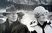 The valley of Jackson Hole remained primarily in private ownership when John D. Rockefeller, Jr.
and his wife visited the region in the late 1920s. Horace Albright had hoped to protect the valley of Jackson Hole north of the town of Jackson from commercial exploitation. Rockefeller agreed and through a private enterprise known as the Snake River Land Company
was by 1927 buying land in Jackson Hole to be later turned over to the National Park Service. In 1930, this plan was revealed to the residents of the region and was met with strong disapproval. By 1942, John D. Rockefeller, Jr. became increasingly impatient that his land holdings in Jackson Hole might never be part of Grand Teton National Park, so he wrote the Secretary of the Interior
Harold L. Ickes
and informed him that he may sell the land to another party. Secretary Ickes recommended to President Franklin Roosevelt that the Antiquities Act
(which permitted Presidents to set aside land for protection without the approval of Congress) be used to establish a National Monument in Jackson Hole. Roosevelt agreed and the property belonging to the Snake River Land Company along with additional land carved from Teton National Forest became the 221000 acres (89,435.6 ha) Jackson Hole National Monument
in 1943. The monument and park were adjacent to each other and administered by the National Park Service, but the monument designation ensured no funding allotment, nor provided a level of resource protection equal to the park. Members of Congress repeatedly attempted to have the new National Monument abolished. After the end of World War II
public sentiment shifted in favor of adding the monument to the park. Though there was still much local disagreement, the monument and park were combined in 1950. In recognition for John D. Rockefeller, Jr.'s efforts to establish and then expand Grand Teton National Park, a 24000 acres (9,712.5 ha) parcel of land between Grand Teton and Yellowstone National Parks was added to the National Park service in 1972. This land along with the road from the southern boundary of Grand Teton National Park to West Thumb in Yellowstone National Park was designated as the John D. Rockefeller, Jr. Memorial Parkway
. In 2001, the Rockefeller family donated the remnants of its JY Ranch for the establishment of the Laurance S. Rockefeller Preserve
, dedicated on June 21, 2008.
, a consequence of Jackson Hole Airport
's presence in the park. Initial construction of the airstrip north of the town of Jackson was completed in the 1930s. When Jackson Hole National Monument was designated, it included land that the airport was situated on. After the monument and park were combined, the Jackson Hole Airport
became the only commercial airport within a U.S. National Park. Jackson Hole Airport has some of the strictest noise abatement
regulations of any airport in the U.S. As of 2010, 110 privately owned property inholding
s, many belonging to the state of Wyoming, are located within Grand Teton National Park. Efforts to purchase or trade these inholdings for other federal lands are ongoing and through partnerships with other entities, 10 million dollars is hoped to be raised to acquire private inholdings by 2016. Grand Teton National Park is one of the ten most visited national parks in the U.S., with an average of 2.5 million visitors annually.
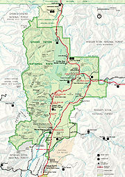 Grand Teton National Park is located in the northwestern region of the U.S. state of Wyoming
. To the north the park is bordered by the John D. Rockefeller, Jr. Memorial Parkway, which is administered by Grand Teton National Park. The scenic highway by the same name passes from the southern boundary of Grand Teton National Park to West Thumb in Yellowstone National Park. Grand Teton National Park covers approximately 310000 acres (125,452.7 ha), while the John D. Rockefeller, Jr. Memorial Parkway includes 23700 acres (9,591.1 ha). Most of the Jackson Hole valley and virtually all the major mountain peaks of the Teton Range are within the park. The Jedediah Smith Wilderness
of Caribou-Targhee National Forest
lies along the western boundary and includes the western slopes of the Teton Range. To the northeast and east lie the Teton Wilderness
and Gros Ventre Wilderness
of Bridger-Teton National Forest
. The southeastern border of the park is the location of the National Elk Refuge
, where migrating herds of elk
from the region spend winters. Privately owned land borders the park to the south and southwest. Grand Teton National Park, along with Yellowstone National Park, surrounding National Forests and related protected areas constitute the 18000000 acres (7,284,348 ha) (28000 sq mi (72,519.7 km²)) Greater Yellowstone Ecosystem. The Greater Yellowstone Ecosystem spans across portions of three states and is the largest intact mid-latitude
ecosystem remaining on Earth. By road, Grand Teton National Park is 275 miles (442.6 km) from Salt Lake City, Utah
and 550 miles (885.1 km) from Denver, Colorado
.
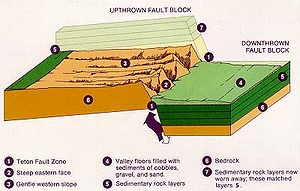
The Teton Range is the youngest mountain range in the Rocky Mountains
, and began forming between 6 to 9 million years ago. The Teton Range runs roughly north to south and rises from the floor of Jackson Hole
without any foothills along a 40 miles (64.4 km) long by 7 to 9 mi (11.3 to 14.5 km) wide active fault-block mountain
front. The range tilts westward, rising abruptly above Jackson Hole valley which lies to the east but more gradually into Teton Valley to the west. A series of earthquake
s along the Teton Fault
slowly displaced the western side of the fault upward and the eastern side of the fault downward at an average of 1 foot (0.3048 m) of displacement every 300–400 years. Most of the displacement of the fault occurred in the last 2 million years. While the fault is believed to experience up to 7.5 earthquake magnitude
events since it formed, the fault has been relatively quiescent during historical periods, with only a few 5.0 magnitude or greater earthquakes known to have occurred since 1850.
 In addition to 13775 ft (4,199 m) high Grand Teton, another nine peaks are over 12000 ft (3,658 m) above sea level
. Eight of these peaks between Avalanche
and Cascade Canyon
s make up the often-photographed Cathedral Group
. The most prominent peak north of Cascade Canyon is the monolithic Mount Moran
(12605 feet (3,842 m)) which rises 5728 feet (1,745.9 m) above Jackson Lake
. To the north of Mount Moran, the range eventually merges into the high altitude Yellowstone Plateau
. South of the central Cathedral Group the Teton Range tapers off near Teton Pass
and blends into the Snake River Range.
West to east trending canyons provide easier access by foot into the heart of the range as no vehicular roads traverse the range except at Teton Pass, which is south of the park. Carved by a combination of glacier
activity as well as by numerous streams, the canyons are at their lowest point along the eastern margin of the range at Jackson Hole. Flowing from higher to lower elevations, the glaciers created more than a dozen U-shaped valley
s throughout the range. Cascade Canyon is sandwiched between Mount Owen and Teewinot Mountain
to the south and Symmetry Spire
to the north and is situated immediately west of Jenny Lake. North to south, Webb
, Moran
, Paintbrush
, Cascade, Death
and Granite Canyon
s slice through Teton Range.
valley with an average elevation of 6800 ft (2,072.6 m), its lowest point is near the southern park boundary at 6350 ft (1,935.5 m). The valley sits east of the Teton Range and is vertically displaced downward 30000 ft (9,144 m) from corresponding rock layers in it, making the Teton Fault and its parallel twin on the east side of the valley normal faults with the Jackson Hole block being the hanging wall and the Teton Mountain block being the footwall. Grand Teton National Park contains the major part of both blocks. A great deal of erosion
of the range and sediment
filling the graben, however, yields a topographic relief of only up to 7700 ft (2,347 m). Jackson Hole is comparatively flat, with only a modest increase in altitude south to north, however a few isolated butte
s such as Blacktail Butte
and hills including Signal Mountain
dot the valley floor. In addition to a few outcroppings, the Snake River
has eroded terraces into the valley floor. Southeast of Jackson Lake, glacial depressions known as kettles are numerous. The kettles were formed when ice situated under gravel outwash from ice sheet
s melted as the glaciers retreated.
, the largest lake in the park at 15 miles (24.1 km) long 5 miles (8 km) wide and 438 feet (133.5 m) deep. Though Jackson Lake is natural, the Jackson Lake Dam
was constructed at its outlet before the creation of the park (since modified) and the lake level was raised almost 40 feet (12.2 m) consequently. East of the Jackson Lake Lodge
lies Emma Matilda
and Two Ocean Lake
s. South of Jackson Lake, Leigh
, Jenny
, Bradley
, Taggart
and Phelps Lake
s can be found near the entrances to the canyons which lead into the Teton Range. Within the Teton Range, smaller lakes are sometimes found in high altitude cirque
s, and there are more than 100 alpine lakes scattered throughout the high country. Lake Solitude
, located at an elevation of 9035 feet (2,753.9 m), is in a cirque at the head of the North Fork of Cascade Canyon. Other high altitude lakes can be found at over 10000 feet (3,048 m) in elevation and a few, such as Icefloe Lake, remain ice clogged for much of the year.
The Snake River flows north to south through the park, entering Jackson Lake near the boundary of Grand Teton National Park and John D. Rockefeller, Jr. Memorial Parkway. The Snake River then flows through the spillways of the Jackson Lake Dam and from there southward through Jackson Hole, exiting the park just west of the Jackson Hole Airport
. The largest lakes in the park all drain either directly or by tributary streams into the Snake River. Major tributaries which flow into the Snake River include Pacific Creek and Buffalo Fork near Moran
and the Gros Ventre River
at the southern border of the park. Through the comparatively level Jackson Hole valley, the Snake River descends an average of 19 feet (5.8 m) per mile (1.6 km), while other streams descending from the mountains to the east and west have higher gradients due to increased slope. The Snake River creates braids
and channels in sections where the gradients are lower and in steeper sections, erodes and undercuts the cobble stone terraces once deposited by glaciers.
s. Commencing 250,000-150,000 years ago, the tetons went through several periods of glaciation with some areas of Jackson Hole covered by glaciers 2000 feet (609.6 m) thick. This heavy glaciation is unrelated to the uplift of the range itself and is instead part of a period of global cooling known as the Ice age
. Beginning with the Buffalo Glaciation and followed by the Bull Lake
and then the Pinedale glaciation, which ended roughly 15,000 years ago, the landscape that later became Grand Teton National Park is one that has been greatly impacted by past glacial activity. During the Pinedale glaciation, the landscape visible today was created as glaciers from the Yellowstone Plateau
flowed south and formed Jackson Lake, while smaller glaciers descending from the Teton range pushed rock moraines out from the canyons and left behind smaller lakes near the base of the mountains. The peaks themselves were carved into horns
and arête
s and and the canyons were transformed from water eroded V-shapes to glacier carved U-shaped valley
s. Approximately a dozen glaciers currently exist in the park, but they are not ancient as they were all reestablished during the Little Ice Age
sometime between 1400 and 1850 AD. Of these more recent glaciers, the largest glacier is Teton Glacier
which sits below the northeast face of Grand Teton. 3500 feet (1,066.8 m) long and 1100 feet (335.3 m) wide, the Teton Glacier is sheltered by the tallest summits in the range. Teton Glacier is the best studied glacier in the range, and researchers concluded in 2005 that the glacier would disappear in 30 to 75 years. West of the Cathedral Group near Hurricane Pass, Schoolroom Glacier
is tiny but it has well defined terminal and lateral moraines, a small proglacial lake
and other traditional glacier features in close proximity to each other.
(4 to 2.5 billion years ago), these metamorphic
rocks include gneiss
, schist
and amphibolite
s. Metamorphic rocks are the most common types found in the northern and southern sections of the Teton Range. 2,545 million years ago, the metamorphic rocks were intruded by igneous
granitic
rocks, which are now visible in the central tetons including Grand Teton and the nearby peaks. The light colored granites of the central Teton Range contrast with the darker metamorphic gneiss found on the flanks of Mount Moran
to the north. Magma
intrusions of diabase
rocks 765 million years ago left dikes
which can seen on the east face of Mount Moran and Middle Teton. Granite and pegmatite
intrusions also worked their way into fissures in the older gneiss. Precambrian
rocks in Jackson Hole are buried deep under comparatively recent Tertiary
volcanic and sedimentary
deposits, as well as Pleistocene
glacial deposits.
By the close of the Precambrian the region was intermittently submerged under shallow seas and for 500 million years various types of sedimentary rocks were formed. During the Paleozoic
(542 to 251 million years ago) sandstone
, shale
, limestone
and dolomite
were deposited. Though most of these sedimentary rocks have since eroded away from the central Teton Range, they are still evident on the northern, southern and western flanks of the range. One notable exception is the sandstone Flathead Formation which continues to cap Mount Moran. Sedimentary layering of rocks in Alaska Basin, which is on the western border of Grand Teton National Park, chronicles a 120 million year period of sedimentary deposition. Fossil
s found in the sedimentary rocks in the park include algae
, brachiopod
s and trilobite
s. Sedimentary deposition continued during the Mesozoic
(250-65 million years ago) and the coal
seams found in the sedimentary rock strata indicate the region was densely forested during that era. Numerous coal seams of 5 to 10 feet in thickness are interspersed with siltstone
, claystone
and other sedimentary rocks. During the late Cretaceous
, a volcanic
arc west of the region deposited fine grained ash which later formed into bentonite
, an important mineral resource.
From the end of the Mesozoic to present, the region went through a series of uplifts and erosional sequences. A mountain-building episode known as the Laramide orogeny
started to uplift western North America
65 million years ago and eventually formed the ancestral Rocky Mountains. This cycle of uplift and erosion left behind one of the most complete non-marine Cenozoic
rock sequences found in North America. Conglomerate
rocks composed of quartzite
and interspersed with mudstone
and sandstones were deposited during erosion from a now vanished mountain range which existed to the northwest of the current Teton Range. These deposits also have trace quantities of gold
and mercury
. During the Eocene
and Oligocene
, volcanic eruptions from the ancestral Absaroka Range
buried the region under various volcanic deposits. Sedimentary basin
s developed in the region due to drop faulting, creating an ancestral Jackson Hole and by the Pliocene
(10 million years ago), an ancestral Jackson Lake known as Teewinot Lake. During the Quaternary
, landslides
, erosion and glacial activity deposited soils and rock debris throughout the Snake River valley of Jackson Hole and left behind terminal moraines which impound the current lakes. The most recent example of rapid alteration to the landscape occurred in 1925 just east of the park, when the Gros Ventre landslide
was triggered by spring melt from a heavy snowpack as well as heavy rain.
 Grand Teton National Park and areas adjacent to it host over 1000 species of vascular plant
s. Whitebark Pine
, Limber Pine
, Subalpine fir
, and Engelmann Spruce
survive in Tetons' alpine zone
up to around 10000 feet (3,048 m). Lodgepole Pine
, Douglas Fir, and Blue Spruce
are found on the valley floor, while the aspen
s, cottonwoods, alder
s, and willow
s commonly inhabit the moist soils along rivers and lakeshores.
 Forests in the Teton area generally consist of two to three different tree species that grow together in a specific habitat
. Edge habitat for various wildlife species is created where these different forest types merge in zones called ecotone
s. Some animals, such as the Red squirrel
, pine marten
, and black bear
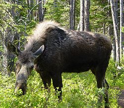
spend a majority of their life in forests. Other animal species, such as moose
, elk
(or wapiti), and wolves, use the forest for shade and shelter in the day and move to sagebrush dominated areas or meadows to feed in the early mornings and evenings.
Soil
conditions, the amount of water, slope, aspect, and elevation all help determine where different plant communities grow. Biologists divide the plants of Grand Teton National Park into these communities: forest
s, sagebrush
flats, riparian corridors and wetland
s, and alpine areas.
Evergreen
forests in the area are composed of seven species
of coniferous tree while over 900 flowering plant
species dominate the Teton Range below the tree line down to the top of Jackson Hole's moraine
s. These moraines are composed of compact piles of unsorted rubble that have good clay
content and retain moisture better than the quartzite
-rich outwash plain, which allows them to support large stands of Lodgepole Pine
s and many other plants.
 Outwash plain areas are covered in a loose soil that doesn't hold moisture well and is therefore only able to support sparse vegetation
such as sagebrush and coarse grasses
. Numerous aspens, cottonwoods, and willows grow along in riparian zones outside of the outwash plain. Grasses, sedges, and wildflower
s dominate in wet meadow
s.
s and badger
s dig burrows into the loess
es, which were blown into the valley between ice ages. High alpine areas of the park support plants that are specially adapted to the harsh conditions. These hardy plants cope with wind, snow, a lack of soil, increased ultraviolet
radiation, rapid and dramatic temperature shifts, and a short growing season. Growing close to the ground in mats like the Alpine Forget-me-not is a common adaptation.
 Grand Teton National Park is located in the heart of the Greater Yellowstone Ecosystem (or biome), one of the largest intact temperate zone ecosystem
s remaining on the planet. This means that many of the animals in the Teton area travel between the two parks and the numerous adjacent National Forest
s.
s have ever been reported within the park. The F4
Teton-Yellowstone tornado was a high altitude tornado which touched down northeast of the park on the border of the Teton Wilderness of Bridger-Teton National Forest and Yellowstone National Park.
on Jackson Lake, the Colter Bay Visitor Center & Indian Arts Museum is open from the beginning of May to the early October. The Colter Bay Visitor Center & Indian Arts Museum has housed the David T. Vernon Indian Arts Exhibit, which included a number of historically significant Native American flutes
. The David T. Vernon Indian Arts Collection was removed from the facility at the close of the season in 2011 as plans are made to possibly build a new facility.
The Colter Bay Visitor Center was built in 1956 and the David T. Vernon collection has been housed in the facility since 1972. The facility at Colter Bay no longer meets the standards for the proper care and display of the Indian arts collection, but once an appropriate facility is constructed, the exhibits will be returned to the park. South of Moose on the Moose–Wilson Road, the Laurance S. Rockefeller Preserve
Center is located on land that was privately owned by Laurance S. Rockefeller and is situated on Phelps Lake. Donated to Grand Teton National Park and opened to the public in 2008, the property was once part of the JY Ranch, the first dude ranch in Jackson Hole. At Jenny Lake, the Jenny Lake Visitor Center is open from mid may to mid September. This visitor center is within the Jenny Lake Ranger Station Historic District
and is the same structure photographer Harrison Crandall had constructed as an art studio in the 1920s.
entities manage lodging facilities inside the park. The largest such facility is the Jackson Lake Lodge
which is managed by the Grand Teton Lodge Company. Located near Jackson Lake Dam
, the Jackson Lake Lodge has a total of 385 rooms, meeting facilities, a retail shop and a restaurant. The Grand Teton Lodge Company also manages the Jenny Lake Lodge
which consists of exclusive cabins and a restaurant and at Colter Bay Village they oversee numerous tourism related facilities including cabins, a restaurant, a grocery store, a laundry and a marina. South of Jackson Lake Dam the Signal Mountain Lodge
is managed by Forever Resorts and provides cabins, a marina, a gas station and a restaurant. The American Alpine Club
offers basic hostel
dormitory style accommodations primarily reserved for mountain climbers at the Grand Teton Climber's Ranch
. Adjacent to the Snake River in Moose, Wyoming, Dornans is an inholding
on private land which has year round cabin accommodations and related facilities. Lodging is also available at the Triangle X Ranch, another private inholding in the park and the last remaining dude ranch within park boundaries.
Wyoming
Wyoming is a state in the mountain region of the Western United States. The western two thirds of the state is covered mostly with the mountain ranges and rangelands in the foothills of the Eastern Rocky Mountains, while the eastern third of the state is high elevation prairie known as the High...
, U.S.
United States
The United States of America is a federal constitutional republic comprising fifty states and a federal district...
The Park consists of approximately 310000 acres (125,452.7 ha) and includes the major peaks of the 40 miles (64.4 km) long Teton Range
Teton Range
The Teton Range is a mountain range of the Rocky Mountains in North America. A north-south range, it is on the Wyoming side of the state's border with Idaho, just south of Yellowstone National Park. Most of the range is in Grand Teton National Park....
as well as most of the northern sections of the valley known as Jackson Hole
Jackson Hole
Jackson Hole, originally called Jackson's Hole, is a valley located in the U.S. state of Wyoming, near the western border with Idaho. The name "hole" derives from language used by early trappers or mountain men, who primarily entered the valley from the north and east and had to descend along...
. Only 10 miles (16.1 km) south of Yellowstone National Park
Yellowstone National Park
Yellowstone National Park, established by the U.S. Congress and signed into law by President Ulysses S. Grant on March 1, 1872, is a national park located primarily in the U.S. state of Wyoming, although it also extends into Montana and Idaho...
, the two parks are connected by the National Park Service
National Park Service
The National Park Service is the U.S. federal agency that manages all national parks, many national monuments, and other conservation and historical properties with various title designations...
managed John D. Rockefeller, Jr. Memorial Parkway
John D. Rockefeller, Jr. Memorial Parkway
John D. Rockefeller, Jr. Memorial Parkway is a scenic road that connects Grand Teton National Park and Yellowstone National Park in Wyoming, United States. It is federally owned and managed by the National Park Service. It is named in remembrance of John D...
. These three protected areas in conjunction with surrounding National Forests
United States National Forest
National Forest is a classification of federal lands in the United States.National Forests are largely forest and woodland areas owned by the federal government and managed by the United States Forest Service, part of the United States Department of Agriculture. Land management of these areas...
constitute the Greater Yellowstone Ecosystem
Greater Yellowstone Ecosystem
The Greater Yellowstone Ecosystem is one of the last remaining large, nearly intact ecosystems in the northern temperate zone of the Earth and is partly located in Yellowstone National Park. Conflict over management has been controversial, and the area is a flagship site among conservation groups...
, which at almost 18000000 acres (7,284,348 ha), is one of the largest intact mid-latitude temperate ecosystems in the world.
Human history of the Grand Teton region dates back at least 11,000 years, when the first nomadic hunter-gatherer
Hunter-gatherer
A hunter-gatherer or forage society is one in which most or all food is obtained from wild plants and animals, in contrast to agricultural societies which rely mainly on domesticated species. Hunting and gathering was the ancestral subsistence mode of Homo, and all modern humans were...
Paleo-Indians would migrate into the region during warmer months in pursuit of food and supplies. In the early 19th century, the first caucasian
White American
White Americans are people of the United States who are considered or consider themselves White. The United States Census Bureau defines White people as those "having origins in any of the original peoples of Europe, the Middle East, or North Africa...
explorers encountered the eastern Shoshone natives
Native Americans in the United States
Native Americans in the United States are the indigenous peoples in North America within the boundaries of the present-day continental United States, parts of Alaska, and the island state of Hawaii. They are composed of numerous, distinct tribes, states, and ethnic groups, many of which survive as...
. Between 1810 and 1840, the region attracted various fur trading companies which vied for control of the lucrative beaver fur. Organized U.S. Government explorations to the region commenced in the 1870s as an offshoot of exploration in Yellowstone. The first permanent settlers in Jackson Hole arrived in the 1880s. Efforts to preserve the region as a national park commenced in the late 19th century and by 1929, Grand Teton National Park was established, protecting the major peaks of the Teton Range. The valley of Jackson Hole remained in private ownership until conservationists led by John D. Rockefeller, Jr.
John D. Rockefeller, Jr.
John Davison Rockefeller, Jr. was a major philanthropist and a pivotal member of the prominent Rockefeller family. He was the sole son among the five children of businessman and Standard Oil industrialist John D. Rockefeller and the father of the five famous Rockefeller brothers...
in the 1930s began purchasing land in Jackson Hole to be added to the existing national park. Against public opinion and with repeated congressional
United States Congress
The United States Congress is the bicameral legislature of the federal government of the United States, consisting of the Senate and the House of Representatives. The Congress meets in the United States Capitol in Washington, D.C....
efforts to repeal it, much of Jackson Hole was also set aside for protection as Jackson Hole National Monument
Jackson Hole National Monument
Jackson Hole National Monument was a wildlife reserve in Jackson Hole, the majority of which is now a part of Grand Teton National Park in Wyoming, United States. It was created by executive order by Franklin Delano Roosevelt in 1943, and met with considerable opposition from Wyoming legislators....
in 1943. In 1950 the monument was abolished and most of the monument acreage was added to Grand Teton National Park.
Grand Teton National Park is named for Grand Teton
Grand Teton
Grand Teton is the highest mountain in Wyoming's Grand Teton National Park, and a classic destination in American mountaineering.- Geography :...
which is the tallest mountain in the Teton Range. At 13775 feet (4,198.6 m), Grand Teton rises abruptly more than 7000 feet (2,133.6 m) above Jackson Hole and is almost 850 feet (259.1 m) higher than Mount Owen
Mount Owen (Wyoming)
Mount Owen is the second highest peak in the Teton Range, Grand Teton National Park in the U.S. state of Wyoming. The peak is named after William O. Owen, who organized the first documented ascent of the Grand Teton in 1898. Mount Owen is part of the Cathedral Group of high Teton peaks, a...
, the second highest summit in the range.
Paleo-Indians and Native Americans
Evidence of hunter-gatherer Paleo-Indian seasonal settlement in what is now Grand Teton National Park indicates that the first humans arrived more than 11,000 years ago. Jackson Hole valley climate then was likely more alpine and colder than the semi-arid climate found today, so the first humans were likely migratory, spending summer months in Jackson Hole and wintering in the valleys west of the Teton Range. Along the shores of Jackson LakeJackson Lake
Jackson Lake is a lake located in north western Wyoming in Grand Teton National Park. The lake is natural, except for the top 33 feet , which is due to the construction of Jackson Lake Dam, built in 1911. This top level of the lake is utilized by farmers in Idaho for irrigation purposes...
, fire pits, tools and what are believed to have been fishing weights have been discovered. One of the tools is similar to those associated with the Clovis culture
Clovis culture
The Clovis culture is a prehistoric Paleo-Indian culture that first appears 11,500 RCYBP , at the end of the last glacial period, characterized by the manufacture of "Clovis points" and distinctive bone and ivory tools...
which is believed to have existed approximately 11,500 years ago. Some of the tools are made of obsidian
Obsidian
Obsidian is a naturally occurring volcanic glass formed as an extrusive igneous rock.It is produced when felsic lava extruded from a volcano cools rapidly with minimum crystal growth...
which chemical analysis indicates was from sources near present day Teton Pass
Teton Pass
Teton Pass is a high mountain pass located in the Teton Range in western Wyoming, between the towns of Jackson, Wyoming and Victor, Idaho. The pass provides access from the Jackson Hole valley to Teton Valley of southeastern Idaho, which includes the Grand Targhee Resort and the town of...
which is south of where Grand Teton National Park is located. Though obsidian was also available north of Jackson Hole, virtually all the obsidian spear points found are from a source to the south, indicating that the main seasonal migratory route for the Paleo-Indian and later cultures was from the south. Elk
Elk
The Elk is the large deer, also called Cervus canadensis or wapiti, of North America and eastern Asia.Elk may also refer to:Other antlered mammals:...
, which winter on the National Elk Refuge
National Elk Refuge
The National Elk Refuge is located in the U.S. state of Wyoming and was created in 1912 to protect habitat and provide sanctuary for the largest elk herd on Earth. The refuge borders the town of Jackson, Wyoming on the northeast while Bridger-Teton National Forest is to the east and Grand Teton...
at the southern end of Jackson Hole and head north into higher altitudes during spring and summer, follow a similar migratory pattern to this day. From 11,000 to about 500 years ago, there is little evidence of change in the migratory patterns amongst the Native American
Native Americans in the United States
Native Americans in the United States are the indigenous peoples in North America within the boundaries of the present-day continental United States, parts of Alaska, and the island state of Hawaii. They are composed of numerous, distinct tribes, states, and ethnic groups, many of which survive as...
groups in the region and no evidence that indicates any permanent human settlement.
When White American explorers first entered the region in the first decade of the 19th century, they encountered the eastern tribes of the Shoshone people. Most of the Shoshone that lived in the mountain vastness of the greater Yellowstone region continued to be pedestrian while other groups of Shoshone that resided in lower elevations had limited use of horse
Horse
The horse is one of two extant subspecies of Equus ferus, or the wild horse. It is a single-hooved mammal belonging to the taxonomic family Equidae. The horse has evolved over the past 45 to 55 million years from a small multi-toed creature into the large, single-toed animal of today...
s. The Shoshone that lived in the Jackson Hole region were known within their culture as the "Sheep-eaters" or "Tukudika" as they referred to themselves since a main staple of their diet was the Bighorn Sheep
Bighorn Sheep
The bighorn sheep is a species of sheep in North America named for its large horns. These horns can weigh up to , while the sheep themselves weigh up to . Recent genetic testing indicates that there are three distinct subspecies of Ovis canadensis, one of which is endangered: Ovis canadensis sierrae...
. The Shoshones of the region continued to follow the same migratory pattern of their predecessors and have been documented as having a close spiritual relationship with the Teton Range. A number of stone enclosures on some of the peaks, including on the upper slopes of Grand Teton (known simply as The Enclosure) are believed to have been used by Shoshone during vision quest
Vision quest
A vision quest is a rite of passage in some Native American cultures.In many Native American groups, the vision quest is a turning point in life taken before puberty to find oneself and the intended spiritual and life direction. When an older child is ready, he or she will go on a personal,...
s. In 1868, the mountain dwelling Shoshone were relocated to the Wind River Indian Reservation
Wind River Indian Reservation
Wind River Indian Reservation is an Indian reservation shared by the Eastern Shoshone and Northern Arapaho tribes of Native Americans in the central western portion of the U.S. state of Wyoming...
east of the Wind River Range
Wind River Range
The Wind River Range , is a mountain range of the Rocky Mountains in western Wyoming in the United States. The range runs roughly NW-SE for approximately 100 miles . The Continental Divide follows the crest of the range and includes Gannett Peak, which at 13,804 feet , is the highest peak...
in Wyoming.
Fur trade exploration
The Lewis and Clark ExpeditionLewis and Clark Expedition
The Lewis and Clark Expedition, or ″Corps of Discovery Expedition" was the first transcontinental expedition to the Pacific Coast by the United States. Commissioned by President Thomas Jefferson and led by two Virginia-born veterans of Indian wars in the Ohio Valley, Meriwether Lewis and William...
(1804–1806) passed well north of the Grand Teton region. During the expedition's return trip from the Pacific Ocean
Pacific Ocean
The Pacific Ocean is the largest of the Earth's oceanic divisions. It extends from the Arctic in the north to the Southern Ocean in the south, bounded by Asia and Australia in the west, and the Americas in the east.At 165.2 million square kilometres in area, this largest division of the World...
, expedition member John Colter
John Colter
John Colter was a member of the Lewis and Clark Expedition . Though party to one of the more famous expeditions in history, Colter is best remembered for explorations he made during the winter of 1807–1808, when Colter became the first known person of European descent to enter the region now known...
was given an early discharge so he could join two fur
Fur
Fur is a synonym for hair, used more in reference to non-human animals, usually mammals; particularly those with extensives body hair coverage. The term is sometimes used to refer to the body hair of an animal as a complete coat, also known as the "pelage". Fur is also used to refer to animal...
trappers who were heading west in search of beaver pelts. Colter was later hired by Manuel Lisa
Manuel Lisa
Manuel Lisa, also known as Manuel de Lisa , was a Spanish-American fur trader, explorer, and United States Indian agent. He was among the founders in St. Louis of the Missouri Fur Company, an early fur trading company...
to lead fur trappers and to explore the region around the Yellowstone River
Yellowstone River
The Yellowstone River is a tributary of the Missouri River, approximately long, in the western United States. Considered the principal tributary of the upper Missouri, the river and its tributaries drain a wide area stretching from the Rocky Mountains in the vicinity of the Yellowstone National...
. It is generally believed that during the winter of 1807/08 Colter passed through Jackson Hole and was the first caucasian to see the Teton Range. In 1810, Lewis and Clark expedition coleader William Clark produced a map of the previous expedition as well as travels made by John Colter in 1807, apparently based on discussions between Clark and Colter when the two met in St. Louis, Missouri
St. Louis, Missouri
St. Louis is an independent city on the eastern border of Missouri, United States. With a population of 319,294, it was the 58th-largest U.S. city at the 2010 U.S. Census. The Greater St...
in 1810. Another map attributed to William Clark indicates John Colter entered Jackson Hole from the northeast, crossing the Continental Divide at either Togwotee Pass
Togwotee Pass
Togwotee Pass is a mountain pass located on the continental divide in the Absaroka Mountains of the United States, between the towns of Dubois and Moran Junction, Wyoming in the Jackson Hole valley....
or Union Pass
Union Pass
Union Pass is a high mountain pass in the Wind River Range of western Wyoming in the United States. The pass is located on the Continental Divide between the Gros Ventre mountains on the west and the Wind River Range on the east. The pass was historically used by Native Americans and early...
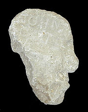
and left the region after crossing Teton Pass, probably following the well established Native American trails. In 1931, the Colter Stone, a carved rock in the shape of a head with the inscription "John Colter" on one side and the year "1808" on the other, was discovered in a field in Tetonia, Idaho
Tetonia, Idaho
Tetonia, Idaho, in Teton County is 50 miles NE of Idaho Falls, Idaho and 425 miles NW of Denver, Colorado. The city is home to some 247 residents....
, which is west of Teton Pass. The Colter Stone has not been authenticated to have been created by John Colter and may have been the work of later expeditions to the region.
Mountain man
Mountain men were trappers and explorers who roamed the North American Rocky Mountains from about 1810 through the 1880s where they were instrumental in opening up the various Emigrant Trails allowing Americans in the east to settle the new territories of the far west by organized wagon trains...
and like those that came to the Jackson Hole region over the next 30 years, was there primarily due to the North American fur trade
North American Fur Trade
The North American fur trade was the industry and activities related to the acquisition, exchange, and sale of animal furs in the North American continent. Indigenous peoples of different regions traded among themselves in the Pre-Columbian Era, but Europeans participated in the trade beginning...
since the region was rich with the highly sought after pelts of beaver
Beaver
The beaver is a primarily nocturnal, large, semi-aquatic rodent. Castor includes two extant species, North American Beaver and Eurasian Beaver . Beavers are known for building dams, canals, and lodges . They are the second-largest rodent in the world...
and other fur bearing animals. Between 1810 and 1811, the Astorians are known to have travelled through Jackson Hole and crossed Teton Pass as they headed east in 1812. British
British Empire
The British Empire comprised the dominions, colonies, protectorates, mandates and other territories ruled or administered by the United Kingdom. It originated with the overseas colonies and trading posts established by England in the late 16th and early 17th centuries. At its height, it was the...
and American fur trading companies vied for control of the fur trade starting in the 1810s as an offshoot of border disputes in the region. One party employed by the British North West Company
North West Company
The North West Company was a fur trading business headquartered in Montreal from 1779 to 1821. It competed with increasing success against the Hudson's Bay Company in what was to become Western Canada...
and led by explorer Donald Mackenzie is believed to have entered Jackson Hole from the west in 1818 or 1819. The Tetons, as well as the valley west of the Teton Range known today as Pierre's Hole
Pierre's Hole
Pierre's Hole, a shallow valley west of the Teton Range that collects the headwaters of the Teton River in what is today the state of Idaho, was a strategic center of the fur trade of the northern Rocky Mountains...
, may have been named by French
French language
French is a Romance language spoken as a first language in France, the Romandy region in Switzerland, Wallonia and Brussels in Belgium, Monaco, the regions of Quebec and Acadia in Canada, and by various communities elsewhere. Second-language speakers of French are distributed throughout many parts...
speaking Iroquois
Iroquois
The Iroquois , also known as the Haudenosaunee or the "People of the Longhouse", are an association of several tribes of indigenous people of North America...
or French Canadian
French Canadian
French Canadian or Francophone Canadian, , generally refers to the descendents of French colonists who arrived in New France in the 17th and 18th centuries...
trappers that were part of Mackenzie's party. Earlier parties had referred to the most prominent peaks of the Teton Range as the Pilot Knobs, however the French trappers "les trois tetons" (the three breasts) was later shortened to the Tetons.
The Rocky Mountain Fur Company
Rocky Mountain Fur Company
The Rocky Mountain Fur Company, sometimes called Ashley's Hundred, was organized in St. Louis, Missouri in 1823 by General William H. Ashley and Major Andrew Henry . They posted advertisements in St. Louis newspapers seeking "One Hundred enterprising young men . ....
partnership included Jedediah Smith
Jedediah Smith
Jedediah Strong Smith was a hunter, trapper, fur trader, trailblazer, author, cartographer, cattleman, and explorer of the Rocky Mountains, the American West Coast and the Southwest during the 19th century...
, William Sublette
William Sublette
William Lewis Sublette Born near Stamford, Lincoln County, Kentucky on September 21, 1798. Died on July 23, 1845 in Pittsburg. W.L. Sublette was a fur trapper, pioneer and mountain man, who with his brothers after 1823 became an agent of the Rocky Mountain Fur Company exploiting the riches of the...
and David Edward Jackson
David Edward Jackson
David Edward Jackson was an American pioneer, explorer, trader, and fur trapper.He spent his early life west of the Shenandoah Mountains, in what was then part of Virginia and is now in West Virginia: he was born in Randolph County, and his parents, Edward and Elizabeth Jackson, soon moved the...
or "Davey Jackson". Jackson oversaw the trapping operations in the Grand Teton region between 1826 and 1830. It is believed that Sublette named the valley east of the Teton Range "Jackson's Hole", (later simply Jackson Hole) for Davey Jackson. As the demand for beaver fur declined and the various regions of the American West became depleted of beaver due to over trapping, American fur trading companies folded but individual mountain men continued to trap beaver in the Jackson Hole region until about 1840. From the mid 1840's until 1860, Jackson Hole and the Teton Range were generally devoid of all but the small populations of native American tribes that had already been there. Most overland human migration routes such as the Oregon
Oregon Trail
The Oregon Trail is a historic east-west wagon route that connected the Missouri River to valleys in Oregon and locations in between.After 1840 steam-powered riverboats and steamboats traversing up and down the Ohio, Mississippi and Missouri rivers sped settlement and development in the flat...
and Mormon Trail
Mormon Trail
The Mormon Trail or Mormon Pioneer Trail is the 1,300 mile route that members of The Church of Jesus Christ of Latter-day Saints traveled from 1846 to 1868...
s crossed over South Pass
South Pass
South Pass is two mountain passes on the Continental Divide in the Rocky Mountains in southwestern Wyoming. The passes are located in a broad low region, 35 miles broad, between the Wind River Range to the north and the Oregon Buttes and Great Divide Basin to the south, in southwestern Fremont...
, well to the south of the Teton Range and caucasian influence in the Teton region was minimal until the U.S. Government
Federal government of the United States
The federal government of the United States is the national government of the constitutional republic of fifty states that is the United States of America. The federal government comprises three distinct branches of government: a legislative, an executive and a judiciary. These branches and...
commenced organized explorations.
Organized exploration and settlement
The 1859-60 Raynolds ExpeditionRaynolds Expedition
The Raynolds Expedition was an United States Army exploring and mapping party which left St. Louis, Missouri May 29, 1859 and was intended to map the unexplored territory between Fort Pierre, Dakota Territory and headwaters of the Yellowstone River. Led by experienced explorer and topographical...
, led by U.S. Army
United States Army
The United States Army is the main branch of the United States Armed Forces responsible for land-based military operations. It is the largest and oldest established branch of the U.S. military, and is one of seven U.S. uniformed services...
Captain William F. Raynolds
William F. Raynolds
William Franklin Raynolds was a U.S. Army Colonel, explorer, engineer, Mexican War and Civil War officer who is best known for leading the 1859-1860 Raynolds Expedition while serving as a member of the U.S. Army Corps of Topographical Engineers...
was guided by mountain man Jim Bridger
Jim Bridger
James Felix "Jim" Bridger was among the foremost mountain men, trappers, scouts and guides who explored and trapped the Western United States during the decades of 1820-1850, as well as mediating between native tribes and encroaching whites...
and included naturalist F. V. Hayden
Ferdinand Vandeveer Hayden
Dr. Ferdinand Vandeveer Hayden was an American geologist noted for his pioneering surveying expeditions of the Rocky Mountains in the late 19th century. He was also a physician who served with the Union Army during the Civil War.-Early life:Ferdinand Hayden was born in Westfield, Massachusetts...
, who later led other expeditions to the region. It was the first major U.S. Government sponsored expedition to enter Jackson Hole. The expedition had been charged with exploring the Yellowstone region, but encountered difficulties crossing mountain passes due to snow. Bridger ended up guiding the expedition south over Union Pass
Union Pass
Union Pass is a high mountain pass in the Wind River Range of western Wyoming in the United States. The pass is located on the Continental Divide between the Gros Ventre mountains on the west and the Wind River Range on the east. The pass was historically used by Native Americans and early...
then following the Gros Ventre River
Gros Ventre River
The Gros Ventre River is a tributary of the Snake River in the state of Wyoming. It rises in the Gros Ventre Wilderness in western Wyoming, and joins the Snake River in the Jackson Hole valley. In 1925, the massive Gros Ventre landslide dammed the river and formed Lower Slide Lake...
drainage to the Snake River and leaving the region over Teton Pass. Organized exploration of the region was halted during the American Civil War
American Civil War
The American Civil War was a civil war fought in the United States of America. In response to the election of Abraham Lincoln as President of the United States, 11 southern slave states declared their secession from the United States and formed the Confederate States of America ; the other 25...
but resumed when F. V. Hayden led the well funded Hayden Geological Survey of 1871
Hayden Geological Survey of 1871
The Hayden Geological Survey of 1871 explored the region of northwestern Wyoming that later became Yellowstone National Park in 1872. It was led by geologist Ferdinand Vandeveer Hayden...
. Split into two divisions, Hayden explored Yellowstone while a smaller group under James Stevenson explored the Teton region. Along with Stevenson was photographer William Henry Jackson
William Henry Jackson
William Henry Jackson was an American painter, Civil War, geological survey photographer and an explorer famous for his images of the American West...
who took the first photographs of the Teton Range. The Hayden Geological Survey is also credited with providing many of the now familiar place names to some of the mountains and lakes in the region. A nearly disastrous and possibly unauthorized expedition led by U.S. Army Lt. Gustavus Cheyney Doane
Gustavus Cheyney Doane
Gustavus Cheyney Doane was a U.S. Army Cavalry Captain, explorer, inventor and Civil War soldier who played a prominent role in the exploration of Yellowstone as a member of the Washburn-Langford-Doane Expedition.-Early life:...
in 1876 enhanced the aura of wildness for which the Tetons were noted. The explorations by early mountain men and subsequent expeditions failed to identify any sources of economically viable mineral wealth in the Teton region. Nevertheless, small groups of prospectors set up claims and mining operations on several of the creeks and rivers. By 1900, all organized efforts to retrieve mineral wealth had been abandoned.
Though the Teton Range was never permanently inhabited, pioneers began settling the Jackson Hole valley to the east in 1884. These earliest homesteaders
Homestead Act
A homestead act is one of three United States federal laws that gave an applicant freehold title to an area called a "homestead" – typically 160 acres of undeveloped federal land west of the Mississippi River....
were mostly single men who endured long winters, short growing seasons and rocky soils which were hard to cultivate. The region was mostly suited for the cultivation of hay and cattle ranching. By 1890, Jackson Hole only had an estimated permanent population of 60. Around 1892 Menor's Ferry
Menor's Ferry
Menor's Ferry was a river ferry that crossed the Snake River near the present-day Moose, Wyoming. The site was homesteaded by Bill Menor in 1892-94, choosing a location where the river flowed in a single channel, rather than the braided stream that characterizes its course in most of Jackson Hole. ...
was built near present day Moose, Wyoming
Moose, Wyoming
Moose is an unincorporated community in Teton County, Wyoming, United States, in the Jackson Hole valley. It has a US Post Office, with the zip code of 83012. The town is located within Grand Teton National Park along the banks of the Snake River...
to provide access for wagons to the west side of the Snake River. Ranching increased significantly from 1900 to 1920 but a series of agricultural related economic downturns in the early 1920s led to the extirpation of wolves in Jackson Hole by the early 1920s as ranchers sought to protect their livelihood. Beginning in the 1920s the automobile provided faster and easier access to areas of natural beauty and old military roads into Jackson Hole over Teton and Togwotee Passes were improved to accommodate the increased vehicle traffic. In response to the increased tourism, dude ranches were established, some new and some from existing cattle ranches. so urbanized travelers could experience life as a cattleman.
Establishment of the park
Grover Cleveland
Stephen Grover Cleveland was the 22nd and 24th president of the United States. Cleveland is the only president to serve two non-consecutive terms and therefore is the only individual to be counted twice in the numbering of the presidents...
to create the Teton Forest Reserve, which included a portion of northern Jackson Hole. By 1902, the reserve was combined into the Yellowstone Forest Reserve, then divided again in 1908 by President Theodore Roosevelt
Theodore Roosevelt
Theodore "Teddy" Roosevelt was the 26th President of the United States . He is noted for his exuberant personality, range of interests and achievements, and his leadership of the Progressive Movement, as well as his "cowboy" persona and robust masculinity...
, establishing the Teton National Forest
Teton National Forest
Teton National Forest was first established by the General Land Office on February 22, 1897 as the Teton Forest Reserve with . A commission was established in 1896 to plan for a system of national forest reserves, recommending an expansion of the territory protected by the Yellowstone Timberland...
, protecting most of the Teton Range. By 1907, the U.S. Bureau of Reclamation had constructed a temporary dam at the Snake River outlet of Jackson Lake
Jackson Lake
Jackson Lake is a lake located in north western Wyoming in Grand Teton National Park. The lake is natural, except for the top 33 feet , which is due to the construction of Jackson Lake Dam, built in 1911. This top level of the lake is utilized by farmers in Idaho for irrigation purposes...
. This dam failed in 1910 and a new concrete Jackson Lake Dam
Jackson Lake Dam
Jackson Lake Dam is a concrete and earth-fill dam at the outlet of Jackson Lake in northwestern Wyoming, USA. The lake and dam are situated within Grand Teton National Park in Teton County. The Snake River emerges from the dam and flows about through Wyoming, Idaho, Oregon, and Washington to its...
replaced it by 1911. The dam was further enlarged in 1916, raising lake waters 39 feet (11.9 m) as part of the Minidoka Project
Minidoka Project
The Minidoka Project is a series of public works by the U.S. Bureau of Reclamation to control the flow of the Snake River in Wyoming and Idaho, supplying irrigation water to farmlands in Idaho...
, designed to provide irrigation for agriculture in the state of Idaho
Idaho
Idaho is a state in the Rocky Mountain area of the United States. The state's largest city and capital is Boise. Residents are called "Idahoans". Idaho was admitted to the Union on July 3, 1890, as the 43rd state....
. Though efforts to protect the Teton Range and Jackson Hole as part of an expanded Yellowstone National Park dated back to the late 19th century, proposals to construct more dams on some of the other lakes in Jackson Hole led Yellowstone National Park superintendent Horace Albright to block such efforts. Albright was originally an advocate of the expanded Yellowstone plan which was very unpopular with local residents. By the mid 1920s however, local sentiment had changed once the proposals for a new national park carved out of land currently protected as part of the Teton National Forest and including only the Teton Range and six lakes at the base of the range were put forward. With the general agreement of prominent Jackson Hole residents on this plan, President Calvin Coolidge
Calvin Coolidge
John Calvin Coolidge, Jr. was the 30th President of the United States . A Republican lawyer from Vermont, Coolidge worked his way up the ladder of Massachusetts state politics, eventually becoming governor of that state...
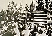
signed the executive order establishing the 96000 acres (38,849.9 ha) Grand Teton National Park on February 26, 1929.
John D. Rockefeller, Jr.
John Davison Rockefeller, Jr. was a major philanthropist and a pivotal member of the prominent Rockefeller family. He was the sole son among the five children of businessman and Standard Oil industrialist John D. Rockefeller and the father of the five famous Rockefeller brothers...
and his wife visited the region in the late 1920s. Horace Albright had hoped to protect the valley of Jackson Hole north of the town of Jackson from commercial exploitation. Rockefeller agreed and through a private enterprise known as the Snake River Land Company
Snake River Land Company
The Snake River Land Company was a land purchasing company established in 1927 by philanthropist John D. Rockefeller, Jr.. The company acted as a front so Rockefeller could buy land in the Jackson Hole valley in Wyoming without people knowing of his involvement or his intentions for the property,...
was by 1927 buying land in Jackson Hole to be later turned over to the National Park Service. In 1930, this plan was revealed to the residents of the region and was met with strong disapproval. By 1942, John D. Rockefeller, Jr. became increasingly impatient that his land holdings in Jackson Hole might never be part of Grand Teton National Park, so he wrote the Secretary of the Interior
United States Secretary of the Interior
The United States Secretary of the Interior is the head of the United States Department of the Interior.The US Department of the Interior should not be confused with the concept of Ministries of the Interior as used in other countries...
Harold L. Ickes
Harold L. Ickes
Harold LeClair Ickes was a United States administrator and politician. He served as United States Secretary of the Interior for 13 years, from 1933 to 1946, the longest tenure of anyone to hold the office, and the second longest serving Cabinet member in U.S. history next to James Wilson. Ickes...
and informed him that he may sell the land to another party. Secretary Ickes recommended to President Franklin Roosevelt that the Antiquities Act
Antiquities Act
The Antiquities Act of 1906, officially An Act for the Preservation of American Antiquities , is an act passed by the United States Congress and signed into law by Theodore Roosevelt on June 8, 1906, giving the President of the United States authority to, by executive order, restrict the use of...
(which permitted Presidents to set aside land for protection without the approval of Congress) be used to establish a National Monument in Jackson Hole. Roosevelt agreed and the property belonging to the Snake River Land Company along with additional land carved from Teton National Forest became the 221000 acres (89,435.6 ha) Jackson Hole National Monument
Jackson Hole National Monument
Jackson Hole National Monument was a wildlife reserve in Jackson Hole, the majority of which is now a part of Grand Teton National Park in Wyoming, United States. It was created by executive order by Franklin Delano Roosevelt in 1943, and met with considerable opposition from Wyoming legislators....
in 1943. The monument and park were adjacent to each other and administered by the National Park Service, but the monument designation ensured no funding allotment, nor provided a level of resource protection equal to the park. Members of Congress repeatedly attempted to have the new National Monument abolished. After the end of World War II
World War II
World War II, or the Second World War , was a global conflict lasting from 1939 to 1945, involving most of the world's nations—including all of the great powers—eventually forming two opposing military alliances: the Allies and the Axis...
public sentiment shifted in favor of adding the monument to the park. Though there was still much local disagreement, the monument and park were combined in 1950. In recognition for John D. Rockefeller, Jr.'s efforts to establish and then expand Grand Teton National Park, a 24000 acres (9,712.5 ha) parcel of land between Grand Teton and Yellowstone National Parks was added to the National Park service in 1972. This land along with the road from the southern boundary of Grand Teton National Park to West Thumb in Yellowstone National Park was designated as the John D. Rockefeller, Jr. Memorial Parkway
John D. Rockefeller, Jr. Memorial Parkway
John D. Rockefeller, Jr. Memorial Parkway is a scenic road that connects Grand Teton National Park and Yellowstone National Park in Wyoming, United States. It is federally owned and managed by the National Park Service. It is named in remembrance of John D...
. In 2001, the Rockefeller family donated the remnants of its JY Ranch for the establishment of the Laurance S. Rockefeller Preserve
Laurance S. Rockefeller Preserve
The Laurance S. Rockefeller Preserve is a refuge within Grand Teton National Park on the southern end of Phelps Lake. The site was originally known as the JY Ranch, a dude ranch. Starting in 1927, John D. Rockefeller, Jr. purchased much of the land in Jackson Hole for the creation of Jackson...
, dedicated on June 21, 2008.
Park management
Grand Teton National Park is administered by the National Park Service, an agency of the Department of the Interior. Grand Teton National Park oversees the John D. Rockefeller, Jr. Memorial Parkway acreage and the associated scenic highway south of Yellowstone National Park. The park has an average of 100 permanent and 180 seasonal employees. The park also manages 27 concession contracts which provide services such as lodging, restaurants, mountaineering guides, dude ranching, fishing and a boat shuttle on Jenny Lake. Grand Teton National Park works closely with other federal agencies such as the U.S. Forest Service, the U.S. Fish and Wildlife Service and the Bureau of Reclamation. The park also works closely with the Federal Aviation AdministrationFederal Aviation Administration
The Federal Aviation Administration is the national aviation authority of the United States. An agency of the United States Department of Transportation, it has authority to regulate and oversee all aspects of civil aviation in the U.S...
, a consequence of Jackson Hole Airport
Jackson Hole Airport
Jackson Hole Airport is a public airport located seven miles north of the central business district of Jackson, a town in Teton County, Wyoming, United States...
's presence in the park. Initial construction of the airstrip north of the town of Jackson was completed in the 1930s. When Jackson Hole National Monument was designated, it included land that the airport was situated on. After the monument and park were combined, the Jackson Hole Airport
Jackson Hole Airport
Jackson Hole Airport is a public airport located seven miles north of the central business district of Jackson, a town in Teton County, Wyoming, United States...
became the only commercial airport within a U.S. National Park. Jackson Hole Airport has some of the strictest noise abatement
Noise mitigation
Noise mitigation is a set of strategies to reduce noise pollution. The main areas of noise mitigation or abatement are: transportation noise control, architectural design, and occupational noise control...
regulations of any airport in the U.S. As of 2010, 110 privately owned property inholding
Inholding
An inholding is privately owned land inside the boundary of a national park, national forest, state park, or similar publicly owned, protected area...
s, many belonging to the state of Wyoming, are located within Grand Teton National Park. Efforts to purchase or trade these inholdings for other federal lands are ongoing and through partnerships with other entities, 10 million dollars is hoped to be raised to acquire private inholdings by 2016. Grand Teton National Park is one of the ten most visited national parks in the U.S., with an average of 2.5 million visitors annually.
Geography
Wyoming
Wyoming is a state in the mountain region of the Western United States. The western two thirds of the state is covered mostly with the mountain ranges and rangelands in the foothills of the Eastern Rocky Mountains, while the eastern third of the state is high elevation prairie known as the High...
. To the north the park is bordered by the John D. Rockefeller, Jr. Memorial Parkway, which is administered by Grand Teton National Park. The scenic highway by the same name passes from the southern boundary of Grand Teton National Park to West Thumb in Yellowstone National Park. Grand Teton National Park covers approximately 310000 acres (125,452.7 ha), while the John D. Rockefeller, Jr. Memorial Parkway includes 23700 acres (9,591.1 ha). Most of the Jackson Hole valley and virtually all the major mountain peaks of the Teton Range are within the park. The Jedediah Smith Wilderness
Jedediah Smith Wilderness
The Jedediah Smith Wilderness is located in the U.S. state of Wyoming. Designated wilderness by Congress in 1984, Jedediah Smith Wilderness is within Caribou-Targhee National Forest and borders Grand Teton National Park. Spanning along the western slopes of the Teton Range, the wilderness ensures a...
of Caribou-Targhee National Forest
Caribou-Targhee National Forest
Caribou-Targhee National Forest is located in the states of Idaho and Wyoming, with a small section in Utah in the United States. The forest is broken into several separate sections and extends over . To the east the forest borders Yellowstone National Park, Grand Teton National Park and...
lies along the western boundary and includes the western slopes of the Teton Range. To the northeast and east lie the Teton Wilderness
Teton Wilderness
Teton Wilderness is located in Wyoming, United States. Created in 1964, the Teton Wilderness is located within Bridger-Teton National Forest and consists of 585,238 acres . The wilderness is bordered on the north by Yellowstone National Park and to the west by Grand Teton National Park and the John...
and Gros Ventre Wilderness
Gros Ventre Wilderness
The Gros Ventre Wilderness is located in Bridger-Teton National Forest in the U.S. state of Wyoming. Most of the Gros Ventre Range is located within the wilderness.U.S. Wilderness Areas do not allow motorized or mechanized vehicles, including bicycles...
of Bridger-Teton National Forest
Bridger-Teton National Forest
Bridger-Teton National Forest is located in western Wyoming, United States. The forest consists of , making it the second largest National Forest outside of Alaska. The forest stretches from Yellowstone National Park, along the eastern boundary of Grand Teton National Park and from there rides...
. The southeastern border of the park is the location of the National Elk Refuge
National Elk Refuge
The National Elk Refuge is located in the U.S. state of Wyoming and was created in 1912 to protect habitat and provide sanctuary for the largest elk herd on Earth. The refuge borders the town of Jackson, Wyoming on the northeast while Bridger-Teton National Forest is to the east and Grand Teton...
, where migrating herds of elk
Elk
The Elk is the large deer, also called Cervus canadensis or wapiti, of North America and eastern Asia.Elk may also refer to:Other antlered mammals:...
from the region spend winters. Privately owned land borders the park to the south and southwest. Grand Teton National Park, along with Yellowstone National Park, surrounding National Forests and related protected areas constitute the 18000000 acres (7,284,348 ha) (28000 sq mi (72,519.7 km²)) Greater Yellowstone Ecosystem. The Greater Yellowstone Ecosystem spans across portions of three states and is the largest intact mid-latitude
Middle latitudes
The middle latitudes are between 23°26'22" North and 66°33'39" North, and between 23°26'22" South and 66°33'39" South latitude, or, the Earth's temperate zones between the tropics and the Arctic and Antarctic. The prevailing winds in the middle latitudes are often very strong...
ecosystem remaining on Earth. By road, Grand Teton National Park is 275 miles (442.6 km) from Salt Lake City, Utah
Utah
Utah is a state in the Western United States. It was the 45th state to join the Union, on January 4, 1896. Approximately 80% of Utah's 2,763,885 people live along the Wasatch Front, centering on Salt Lake City. This leaves vast expanses of the state nearly uninhabited, making the population the...
and 550 miles (885.1 km) from Denver, Colorado
Colorado
Colorado is a U.S. state that encompasses much of the Rocky Mountains as well as the northeastern portion of the Colorado Plateau and the western edge of the Great Plains...
.
Teton Range
The Teton Range is the youngest mountain range in the Rocky Mountains
Rocky Mountains
The Rocky Mountains are a major mountain range in western North America. The Rocky Mountains stretch more than from the northernmost part of British Columbia, in western Canada, to New Mexico, in the southwestern United States...
, and began forming between 6 to 9 million years ago. The Teton Range runs roughly north to south and rises from the floor of Jackson Hole
Jackson Hole
Jackson Hole, originally called Jackson's Hole, is a valley located in the U.S. state of Wyoming, near the western border with Idaho. The name "hole" derives from language used by early trappers or mountain men, who primarily entered the valley from the north and east and had to descend along...
without any foothills along a 40 miles (64.4 km) long by 7 to 9 mi (11.3 to 14.5 km) wide active fault-block mountain
Fault-block mountain
Fault-block landforms are formed when large areas of bedrock are widely broken up by faults creating large vertical displacements of continental crust....
front. The range tilts westward, rising abruptly above Jackson Hole valley which lies to the east but more gradually into Teton Valley to the west. A series of earthquake
Earthquake
An earthquake is the result of a sudden release of energy in the Earth's crust that creates seismic waves. The seismicity, seismism or seismic activity of an area refers to the frequency, type and size of earthquakes experienced over a period of time...
s along the Teton Fault
Teton Fault
The Teton fault is a normal fault located in northwestern Wyoming. The fault has a length of 44 miles and runs along the eastern base of the Teton Range. Vertical movement on the fault has caused the dramatic topography of the Teton Range....
slowly displaced the western side of the fault upward and the eastern side of the fault downward at an average of 1 foot (0.3048 m) of displacement every 300–400 years. Most of the displacement of the fault occurred in the last 2 million years. While the fault is believed to experience up to 7.5 earthquake magnitude
Mercalli intensity scale
The Mercalli intensity scale is a seismic scale used for measuring the intensity of an earthquake. It measures the effects of an earthquake, and is distinct from the moment magnitude M_w usually reported for an earthquake , which is a measure of the energy released...
events since it formed, the fault has been relatively quiescent during historical periods, with only a few 5.0 magnitude or greater earthquakes known to have occurred since 1850.
Sea level
Mean sea level is a measure of the average height of the ocean's surface ; used as a standard in reckoning land elevation...
. Eight of these peaks between Avalanche
Avalanche Canyon
Avalanche Canyon is located in Grand Teton National Park, in the U. S. state of Wyoming. The canyon was formed by glaciers which retreated at the end of the last glacial maximum approximately 15,000 years ago, leaving behind a U-shaped valley. To the north of Avalanche Canyon lies South Teton,...
and Cascade Canyon
Cascade Canyon
Cascade Canyon is located in Grand Teton National Park, in the U. S. state of Wyoming. The canyon was formed by glaciers which retreated at the end of the last glacial maximum approximately 15,000 years ago...
s make up the often-photographed Cathedral Group
Cathedral Group
The Cathedral Group is a term applied to a collection of most of the tallest mountains of the Teton Range, all of which are located in Grand Teton National Park, in the U.S. state of Wyoming. The collection of mountains known as the Cathedral Group are classic alpine peaks, with pyramidal shapes...
. The most prominent peak north of Cascade Canyon is the monolithic Mount Moran
Mount Moran
Mount Moran is a mountain in Grand Teton National Park of western Wyoming, USA. The mountain is named for Thomas Moran, an American western frontier landscape artist. Mount Moran dominates the northern section of the Teton Range rising above Jackson Lake. Several active glaciers exist on the...
(12605 feet (3,842 m)) which rises 5728 feet (1,745.9 m) above Jackson Lake
Jackson Lake
Jackson Lake is a lake located in north western Wyoming in Grand Teton National Park. The lake is natural, except for the top 33 feet , which is due to the construction of Jackson Lake Dam, built in 1911. This top level of the lake is utilized by farmers in Idaho for irrigation purposes...
. To the north of Mount Moran, the range eventually merges into the high altitude Yellowstone Plateau
Yellowstone Plateau
The Yellowstone Plateau volcanic field is a geological feature found in the U.S. state of Wyoming. It is a popular site for tourists.The plateau developed through three volcanic cycles spanning two million years that included some of the world's largest known eruptions...
. South of the central Cathedral Group the Teton Range tapers off near Teton Pass
Teton Pass
Teton Pass is a high mountain pass located in the Teton Range in western Wyoming, between the towns of Jackson, Wyoming and Victor, Idaho. The pass provides access from the Jackson Hole valley to Teton Valley of southeastern Idaho, which includes the Grand Targhee Resort and the town of...
and blends into the Snake River Range.
West to east trending canyons provide easier access by foot into the heart of the range as no vehicular roads traverse the range except at Teton Pass, which is south of the park. Carved by a combination of glacier
Glacier
A glacier is a large persistent body of ice that forms where the accumulation of snow exceeds its ablation over many years, often centuries. At least 0.1 km² in area and 50 m thick, but often much larger, a glacier slowly deforms and flows due to stresses induced by its weight...
activity as well as by numerous streams, the canyons are at their lowest point along the eastern margin of the range at Jackson Hole. Flowing from higher to lower elevations, the glaciers created more than a dozen U-shaped valley
U-shaped valley
A U-shaped valley also known as a glacial trough is one formed by the process of glaciation. It has a characteristic U-shape, with steep, straight sides, and a flat bottom. Glaciated valleys are formed when a glacier travels across and down a slope, carving the valley by the action of scouring...
s throughout the range. Cascade Canyon is sandwiched between Mount Owen and Teewinot Mountain
Teewinot Mountain
Teewinot Mountain is the sixth highest peak in the Teton Range, Grand Teton National Park, Wyoming. The name of the mountain is derived from the Shoshone Native American word meaning "many pinnacles". The peak is northeast of the Grand Teton and the two are separated from one another by the Teton...
to the south and Symmetry Spire
Symmetry Spire
Symmetry Spire is located in the Teton Range, Grand Teton National Park in the U.S. state of Wyoming. The mountain, first climbed via the east ridge route on August 20, 1929 by Fritiof Fryxell and Phil Smith, towers above the northwest shore of Jenny Lake and Cascade Canyon...
to the north and is situated immediately west of Jenny Lake. North to south, Webb
Webb Canyon
Webb Canyon is located in Grand Teton National Park, in the U. S. state of Wyoming. The canyon was formed by glaciers which retreated at the end of the last glacial maximum approximately 15,000 years ago, leaving behind a U-shaped valley. Webb Canyon is south of Owl Peak and the entrance to the...
, Moran
Moran Canyon (Wyoming)
Moran Canyon is located in Grand Teton National Park, in the U. S. state of Wyoming. The canyon lies between Mount Moran to the south and Traverse Peak and Bivouac Peak to the north. Moran Bay, part of Jackson Lake, is at the mouth of the canyon to the east. The canyon was formed by glaciers...
, Paintbrush
Paintbrush Canyon
Paintbrush Canyon is located in Grand Teton National Park, in the U. S. state of Wyoming. The canyon was formed by glaciers which retreated at the end of the last glacial maximum approximately 15,000 years ago. The canyon lies between Rockchuck Peak and Mount Saint John to the south and Mount...
, Cascade, Death
Death Canyon
Death Canyon is located in Grand Teton National Park, in the U. S. state of Wyoming. The canyon was formed by glaciers which retreated at the end of the last glacial maximum approximately 15,000 years ago, leaving behind a U-shaped valley. The trailhead for the canyon is located on a side road off...
and Granite Canyon
Granite Canyon
Granite Canyon is located in Grand Teton National Park, in the U. S. state of Wyoming. The canyon was formed by glaciers which retreated at the end of the last glacial maximum approximately 15,000 years ago, leaving behind a U-shaped valley. The canyon lies between Rendezvous Mountain to the south...
s slice through Teton Range.
Jackson Hole
Jackson Hole is a 55 miles (88.5 km) long by 6 to 13 mi (9.7 to 20.9 km) wide grabenGraben
In geology, a graben is a depressed block of land bordered by parallel faults. Graben is German for ditch. Graben is used for both the singular and plural....
valley with an average elevation of 6800 ft (2,072.6 m), its lowest point is near the southern park boundary at 6350 ft (1,935.5 m). The valley sits east of the Teton Range and is vertically displaced downward 30000 ft (9,144 m) from corresponding rock layers in it, making the Teton Fault and its parallel twin on the east side of the valley normal faults with the Jackson Hole block being the hanging wall and the Teton Mountain block being the footwall. Grand Teton National Park contains the major part of both blocks. A great deal of erosion
Erosion
Erosion is when materials are removed from the surface and changed into something else. It only works by hydraulic actions and transport of solids in the natural environment, and leads to the deposition of these materials elsewhere...
of the range and sediment
Sediment
Sediment is naturally occurring material that is broken down by processes of weathering and erosion, and is subsequently transported by the action of fluids such as wind, water, or ice, and/or by the force of gravity acting on the particle itself....
filling the graben, however, yields a topographic relief of only up to 7700 ft (2,347 m). Jackson Hole is comparatively flat, with only a modest increase in altitude south to north, however a few isolated butte
Butte
A butte is a conspicuous isolated hill with steep, often vertical sides and a small, relatively flat top; it is smaller than mesas, plateaus, and table landform tables. In some regions, such as the north central and northwestern United States, the word is used for any hill...
s such as Blacktail Butte
Blacktail Butte
Blacktail Butte is a butte mountain landform rising from Jackson Hole valley in Grand Teton National Park in the U.S. state of Wyoming. Blacktail Butte was originally named Upper Gros Ventre Butte in an early historical survey conducted by the U.S. Geological Survey...
and hills including Signal Mountain
Signal Mountain (Wyoming)
Signal Mountain is an isolated summit standing above sea level. The mountain is located in Grand Teton National Park in the U.S. state of Wyoming. The next closest higher summit is more than distant, and this isolation provides sweeping views of the Teton Range, much of the northern Jackson Hole...
dot the valley floor. In addition to a few outcroppings, the Snake River
Snake River
The Snake is a major river of the greater Pacific Northwest in the United States. At long, it is the largest tributary of the Columbia River, the largest North American river that empties into the Pacific Ocean...
has eroded terraces into the valley floor. Southeast of Jackson Lake, glacial depressions known as kettles are numerous. The kettles were formed when ice situated under gravel outwash from ice sheet
Ice sheet
An ice sheet is a mass of glacier ice that covers surrounding terrain and is greater than 50,000 km² , thus also known as continental glacier...
s melted as the glaciers retreated.
Lakes and rivers
Most of the lakes in Grand Teton National Park were formed by glaciers and the majority of these lakes are located at the base of the Teton Range. In the northern section of the park lies Jackson LakeJackson Lake
Jackson Lake is a lake located in north western Wyoming in Grand Teton National Park. The lake is natural, except for the top 33 feet , which is due to the construction of Jackson Lake Dam, built in 1911. This top level of the lake is utilized by farmers in Idaho for irrigation purposes...
, the largest lake in the park at 15 miles (24.1 km) long 5 miles (8 km) wide and 438 feet (133.5 m) deep. Though Jackson Lake is natural, the Jackson Lake Dam
Jackson Lake Dam
Jackson Lake Dam is a concrete and earth-fill dam at the outlet of Jackson Lake in northwestern Wyoming, USA. The lake and dam are situated within Grand Teton National Park in Teton County. The Snake River emerges from the dam and flows about through Wyoming, Idaho, Oregon, and Washington to its...
was constructed at its outlet before the creation of the park (since modified) and the lake level was raised almost 40 feet (12.2 m) consequently. East of the Jackson Lake Lodge
Jackson Lake Lodge
Jackson Lake Lodge is located in Grand Teton National Park, in the U. S. state of Wyoming. The lodge has 385 rooms, a restaurant, conference rooms, and offers numerous recreational opportunities. The lodge is managed by the Grand Teton Lodge Company, and is not affiliated with the National Park...
lies Emma Matilda
Emma Matilda Lake
Emma Matilda Lake is located in Grand Teton National Park, in the U. S. state of Wyoming. The lake is named after the wife of William O. Owen who was the first, along with three other climbers, to ascend to the summit of Grand Teton in 1898...
and Two Ocean Lake
Two Ocean Lake
Two Ocean Lake is located in Grand Teton National Park, in the U. S. state of Wyoming. The glacially formed lake is long and can be reached from a parking area adjacent to the lake. A trail circles the lake passing through forests and clearings. The larger Emma Matilda Lake is one mile to the...
s. South of Jackson Lake, Leigh
Leigh Lake
Leigh Lake is located in Grand Teton National Park, in the U. S. state of Wyoming. The glacially formed lake is wide and slightly longer in length from north to south. Situated just southeast of Mount Moran, the lake is at the terminus of both Paintbrush and Leigh Canyons...
, Jenny
Jenny Lake
Jenny Lake is located in Grand Teton National Park in the U.S. state of Wyoming. The lake was formed approximately 12,000 years ago by glaciers pushing rock debris which carved Cascade Canyon during the last glacial maximum, forming a terminal moraine which now impounds the lake. The lake is...
, Bradley
Bradley Lake
Bradley Lake is located in Grand Teton National Park, in the U. S. state of Wyoming. The glacially formed lake is located near the terminus of Garnet Canyon. A number of hiking trails can be found near the lake including a roundtrip hike commencing from the Taggart Lake Trail parking area. The...
, Taggart
Taggart Lake
Taggart Lake is located in Grand Teton National Park, in the U. S. state of Wyoming. The natural lake is located at the terminus of Avalanche Canyon. A number of hiking trails can be found near the lake including a roundtrip hike commencing from the Taggart Lake Trail parking area. The lake is...
and Phelps Lake
Phelps Lake (Wyoming)
Phelps Lake is located in Grand Teton National Park, in the U. S. state of Wyoming. The natural lake is located at the entrance to Death Canyon in the southern section of the park...
s can be found near the entrances to the canyons which lead into the Teton Range. Within the Teton Range, smaller lakes are sometimes found in high altitude cirque
Cirque (landform)
thumb|250 px|Two cirques with semi-permanent snowpatches in [[Abisko National Park]], [[Sweden]].A cirque or corrie is an amphitheatre-like valley head, formed at the head of a valley glacier by erosion...
s, and there are more than 100 alpine lakes scattered throughout the high country. Lake Solitude
Lake Solitude (Wyoming)
Lake Solitude is a lake located in Grand Teton National Park, in the U.S. state of Wyoming. The in circumference natural lake is situated at the head of north Cascade Canyon and is a popular destination for hikers and backpackers. From the Cascade Canyon trailhead on the west shore of Jenny Lake,...
, located at an elevation of 9035 feet (2,753.9 m), is in a cirque at the head of the North Fork of Cascade Canyon. Other high altitude lakes can be found at over 10000 feet (3,048 m) in elevation and a few, such as Icefloe Lake, remain ice clogged for much of the year.
The Snake River flows north to south through the park, entering Jackson Lake near the boundary of Grand Teton National Park and John D. Rockefeller, Jr. Memorial Parkway. The Snake River then flows through the spillways of the Jackson Lake Dam and from there southward through Jackson Hole, exiting the park just west of the Jackson Hole Airport
Jackson Hole Airport
Jackson Hole Airport is a public airport located seven miles north of the central business district of Jackson, a town in Teton County, Wyoming, United States...
. The largest lakes in the park all drain either directly or by tributary streams into the Snake River. Major tributaries which flow into the Snake River include Pacific Creek and Buffalo Fork near Moran
Moran, Wyoming
Moran is an unincorporated community in south central Teton County, Wyoming, United States, which serves as one of the principal fee collection entrances to Grand Teton National Park. It lies in Grand Teton National Park northeast of the city of Jackson, the county seat of Teton County, at the...
and the Gros Ventre River
Gros Ventre River
The Gros Ventre River is a tributary of the Snake River in the state of Wyoming. It rises in the Gros Ventre Wilderness in western Wyoming, and joins the Snake River in the Jackson Hole valley. In 1925, the massive Gros Ventre landslide dammed the river and formed Lower Slide Lake...
at the southern border of the park. Through the comparatively level Jackson Hole valley, the Snake River descends an average of 19 feet (5.8 m) per mile (1.6 km), while other streams descending from the mountains to the east and west have higher gradients due to increased slope. The Snake River creates braids
Braided river
A braided river is one of a number of channel types and has a channel that consists of a network of small channels separated by small and often temporary islands called braid bars or, in British usage, aits or eyots. Braided streams occur in rivers with high slope and/or large sediment load...
and channels in sections where the gradients are lower and in steeper sections, erodes and undercuts the cobble stone terraces once deposited by glaciers.
Glaciation
The major peaks of the Teton Range were carved into their current shapes by long vanished glacierGlacier
A glacier is a large persistent body of ice that forms where the accumulation of snow exceeds its ablation over many years, often centuries. At least 0.1 km² in area and 50 m thick, but often much larger, a glacier slowly deforms and flows due to stresses induced by its weight...
s. Commencing 250,000-150,000 years ago, the tetons went through several periods of glaciation with some areas of Jackson Hole covered by glaciers 2000 feet (609.6 m) thick. This heavy glaciation is unrelated to the uplift of the range itself and is instead part of a period of global cooling known as the Ice age
Ice age
An ice age or, more precisely, glacial age, is a generic geological period of long-term reduction in the temperature of the Earth's surface and atmosphere, resulting in the presence or expansion of continental ice sheets, polar ice sheets and alpine glaciers...
. Beginning with the Buffalo Glaciation and followed by the Bull Lake
Bull Lake glaciation
The Bull Lake glaciation is the name of a glacial period in North America that is part of the Quaternary Ice Age. The Bull Lake glaciation began about 200,000 years ago and ended about 130,000 years ago, and was concurrent with the Illinoian Stage of the Quaternary Ice Age...
and then the Pinedale glaciation, which ended roughly 15,000 years ago, the landscape that later became Grand Teton National Park is one that has been greatly impacted by past glacial activity. During the Pinedale glaciation, the landscape visible today was created as glaciers from the Yellowstone Plateau
Yellowstone Plateau
The Yellowstone Plateau volcanic field is a geological feature found in the U.S. state of Wyoming. It is a popular site for tourists.The plateau developed through three volcanic cycles spanning two million years that included some of the world's largest known eruptions...
flowed south and formed Jackson Lake, while smaller glaciers descending from the Teton range pushed rock moraines out from the canyons and left behind smaller lakes near the base of the mountains. The peaks themselves were carved into horns
Pyramidal peak
A pyramidal peak, or sometimes in its most extreme form called a glacial horn, is a mountaintop that has been modified by the action of ice during glaciation and frost weathering...
and arête
Arete
Areté is the term meaning "virtue" or "excellence", from Greek ἈρετήArete may also be used:*as a given name of persons or things:**Queen Arete , a character in Homer's Odyssey.***197 Arete, an asteroid....
s and and the canyons were transformed from water eroded V-shapes to glacier carved U-shaped valley
U-shaped valley
A U-shaped valley also known as a glacial trough is one formed by the process of glaciation. It has a characteristic U-shape, with steep, straight sides, and a flat bottom. Glaciated valleys are formed when a glacier travels across and down a slope, carving the valley by the action of scouring...
s. Approximately a dozen glaciers currently exist in the park, but they are not ancient as they were all reestablished during the Little Ice Age
Little Ice Age
The Little Ice Age was a period of cooling that occurred after the Medieval Warm Period . While not a true ice age, the term was introduced into the scientific literature by François E. Matthes in 1939...
sometime between 1400 and 1850 AD. Of these more recent glaciers, the largest glacier is Teton Glacier
Teton Glacier
Teton Glacier is located below the north face of Grand Teton in Grand Teton National Park, Wyoming and is surrounded by Mount Owen to the west and by Teewinot Mountain to the north, which comprise the peaks of the Cathedral Group. Teton Glacier is the largest of the twelve named glaciers in the...
which sits below the northeast face of Grand Teton. 3500 feet (1,066.8 m) long and 1100 feet (335.3 m) wide, the Teton Glacier is sheltered by the tallest summits in the range. Teton Glacier is the best studied glacier in the range, and researchers concluded in 2005 that the glacier would disappear in 30 to 75 years. West of the Cathedral Group near Hurricane Pass, Schoolroom Glacier
Schoolroom Glacier
Schoolroom Glacier is a small glacier located in Grand Teton National Park in the U.S. state of Wyoming. This Teton Range glacier lies adjacent to the south Cascade Canyon trail at an altitude of , approximately from the trailhead at Jenny Lake...
is tiny but it has well defined terminal and lateral moraines, a small proglacial lake
Proglacial lake
In geology, a proglacial lake is a lake formed either by the damming action of a moraine or ice dam during the retreat of a melting glacier, or by meltwater trapped against an ice sheet due to isostatic depression of the crust around the ice...
and other traditional glacier features in close proximity to each other.
Geology
Grand Teton National Park has some of the most ancient rocks found in any U.S. National Park. The oldest rocks dated so far are 2,680 ± 12 million years old, though even older rocks are believed to exist in the park. Formed during the Archean EonArchean
The Archean , also spelled Archeozoic or Archæozoic) is a geologic eon before the Paleoproterozoic Era of the Proterozoic Eon, before 2.5 Ga ago. Instead of being based on stratigraphy, this date is defined chronometrically...
(4 to 2.5 billion years ago), these metamorphic
Metamorphic rock
Metamorphic rock is the transformation of an existing rock type, the protolith, in a process called metamorphism, which means "change in form". The protolith is subjected to heat and pressure causing profound physical and/or chemical change...
rocks include gneiss
Gneiss
Gneiss is a common and widely distributed type of rock formed by high-grade regional metamorphic processes from pre-existing formations that were originally either igneous or sedimentary rocks.-Etymology:...
, schist
Schist
The schists constitute a group of medium-grade metamorphic rocks, chiefly notable for the preponderance of lamellar minerals such as micas, chlorite, talc, hornblende, graphite, and others. Quartz often occurs in drawn-out grains to such an extent that a particular form called quartz schist is...
and amphibolite
Amphibolite
Amphibolite is the name given to a rock consisting mainly of hornblende amphibole, the use of the term being restricted, however, to metamorphic rocks. The modern terminology for a holocrystalline plutonic igneous rocks composed primarily of hornblende amphibole is a hornblendite, which are...
s. Metamorphic rocks are the most common types found in the northern and southern sections of the Teton Range. 2,545 million years ago, the metamorphic rocks were intruded by igneous
Igneous rock
Igneous rock is one of the three main rock types, the others being sedimentary and metamorphic rock. Igneous rock is formed through the cooling and solidification of magma or lava...
granitic
Granite
Granite is a common and widely occurring type of intrusive, felsic, igneous rock. Granite usually has a medium- to coarse-grained texture. Occasionally some individual crystals are larger than the groundmass, in which case the texture is known as porphyritic. A granitic rock with a porphyritic...
rocks, which are now visible in the central tetons including Grand Teton and the nearby peaks. The light colored granites of the central Teton Range contrast with the darker metamorphic gneiss found on the flanks of Mount Moran
Mount Moran
Mount Moran is a mountain in Grand Teton National Park of western Wyoming, USA. The mountain is named for Thomas Moran, an American western frontier landscape artist. Mount Moran dominates the northern section of the Teton Range rising above Jackson Lake. Several active glaciers exist on the...
to the north. Magma
Magma
Magma is a mixture of molten rock, volatiles and solids that is found beneath the surface of the Earth, and is expected to exist on other terrestrial planets. Besides molten rock, magma may also contain suspended crystals and dissolved gas and sometimes also gas bubbles. Magma often collects in...
intrusions of diabase
Diabase
Diabase or dolerite is a mafic, holocrystalline, subvolcanic rock equivalent to volcanic basalt or plutonic gabbro. In North American usage, the term diabase refers to the fresh rock, whilst elsewhere the term dolerite is used for the fresh rock and diabase refers to altered material...
rocks 765 million years ago left dikes
Dike (geology)
A dike or dyke in geology is a type of sheet intrusion referring to any geologic body that cuts discordantly across* planar wall rock structures, such as bedding or foliation...
which can seen on the east face of Mount Moran and Middle Teton. Granite and pegmatite
Pegmatite
A pegmatite is a very crystalline, intrusive igneous rock composed of interlocking crystals usually larger than 2.5 cm in size; such rocks are referred to as pegmatitic....
intrusions also worked their way into fissures in the older gneiss. Precambrian
Precambrian
The Precambrian is the name which describes the large span of time in Earth's history before the current Phanerozoic Eon, and is a Supereon divided into several eons of the geologic time scale...
rocks in Jackson Hole are buried deep under comparatively recent Tertiary
Tertiary
The Tertiary is a deprecated term for a geologic period 65 million to 2.6 million years ago. The Tertiary covered the time span between the superseded Secondary period and the Quaternary...
volcanic and sedimentary
Sedimentary rock
Sedimentary rock are types of rock that are formed by the deposition of material at the Earth's surface and within bodies of water. Sedimentation is the collective name for processes that cause mineral and/or organic particles to settle and accumulate or minerals to precipitate from a solution....
deposits, as well as Pleistocene
Pleistocene
The Pleistocene is the epoch from 2,588,000 to 11,700 years BP that spans the world's recent period of repeated glaciations. The name pleistocene is derived from the Greek and ....
glacial deposits.
By the close of the Precambrian the region was intermittently submerged under shallow seas and for 500 million years various types of sedimentary rocks were formed. During the Paleozoic
Paleozoic
The Paleozoic era is the earliest of three geologic eras of the Phanerozoic eon, spanning from roughly...
(542 to 251 million years ago) sandstone
Sandstone
Sandstone is a sedimentary rock composed mainly of sand-sized minerals or rock grains.Most sandstone is composed of quartz and/or feldspar because these are the most common minerals in the Earth's crust. Like sand, sandstone may be any colour, but the most common colours are tan, brown, yellow,...
, shale
Shale
Shale is a fine-grained, clastic sedimentary rock composed of mud that is a mix of flakes of clay minerals and tiny fragments of other minerals, especially quartz and calcite. The ratio of clay to other minerals is variable. Shale is characterized by breaks along thin laminae or parallel layering...
, limestone
Limestone
Limestone is a sedimentary rock composed largely of the minerals calcite and aragonite, which are different crystal forms of calcium carbonate . Many limestones are composed from skeletal fragments of marine organisms such as coral or foraminifera....
and dolomite
Dolomite
Dolomite is a carbonate mineral composed of calcium magnesium carbonate CaMg2. The term is also used to describe the sedimentary carbonate rock dolostone....
were deposited. Though most of these sedimentary rocks have since eroded away from the central Teton Range, they are still evident on the northern, southern and western flanks of the range. One notable exception is the sandstone Flathead Formation which continues to cap Mount Moran. Sedimentary layering of rocks in Alaska Basin, which is on the western border of Grand Teton National Park, chronicles a 120 million year period of sedimentary deposition. Fossil
Fossil
Fossils are the preserved remains or traces of animals , plants, and other organisms from the remote past...
s found in the sedimentary rocks in the park include algae
Algae
Algae are a large and diverse group of simple, typically autotrophic organisms, ranging from unicellular to multicellular forms, such as the giant kelps that grow to 65 meters in length. They are photosynthetic like plants, and "simple" because their tissues are not organized into the many...
, brachiopod
Brachiopod
Brachiopods are a phylum of marine animals that have hard "valves" on the upper and lower surfaces, unlike the left and right arrangement in bivalve molluscs. Brachiopod valves are hinged at the rear end, while the front can be opened for feeding or closed for protection...
s and trilobite
Trilobite
Trilobites are a well-known fossil group of extinct marine arthropods that form the class Trilobita. The first appearance of trilobites in the fossil record defines the base of the Atdabanian stage of the Early Cambrian period , and they flourished throughout the lower Paleozoic era before...
s. Sedimentary deposition continued during the Mesozoic
Mesozoic
The Mesozoic era is an interval of geological time from about 250 million years ago to about 65 million years ago. It is often referred to as the age of reptiles because reptiles, namely dinosaurs, were the dominant terrestrial and marine vertebrates of the time...
(250-65 million years ago) and the coal
Coal
Coal is a combustible black or brownish-black sedimentary rock usually occurring in rock strata in layers or veins called coal beds or coal seams. The harder forms, such as anthracite coal, can be regarded as metamorphic rock because of later exposure to elevated temperature and pressure...
seams found in the sedimentary rock strata indicate the region was densely forested during that era. Numerous coal seams of 5 to 10 feet in thickness are interspersed with siltstone
Siltstone
Siltstone is a sedimentary rock which has a grain size in the silt range, finer than sandstone and coarser than claystones.- Description :As its name implies, it is primarily composed of silt sized particles, defined as grains 1/16 - 1/256 mm or 4 to 8 on the Krumbein phi scale...
, claystone
Claystone
Claystone is a geological term used to describe a clastic sedimentary rock that is composed primarily of clay-sized particles ....
and other sedimentary rocks. During the late Cretaceous
Cretaceous
The Cretaceous , derived from the Latin "creta" , usually abbreviated K for its German translation Kreide , is a geologic period and system from circa to million years ago. In the geologic timescale, the Cretaceous follows the Jurassic period and is followed by the Paleogene period of the...
, a volcanic
Volcano
2. Bedrock3. Conduit 4. Base5. Sill6. Dike7. Layers of ash emitted by the volcano8. Flank| 9. Layers of lava emitted by the volcano10. Throat11. Parasitic cone12. Lava flow13. Vent14. Crater15...
arc west of the region deposited fine grained ash which later formed into bentonite
Bentonite
Bentonite is an absorbent aluminium phyllosilicate, essentially impure clay consisting mostly of montmorillonite. There are different types of bentonite, each named after the respective dominant element, such as potassium , sodium , calcium , and aluminum . Experts debate a number of nomenclatorial...
, an important mineral resource.
From the end of the Mesozoic to present, the region went through a series of uplifts and erosional sequences. A mountain-building episode known as the Laramide orogeny
Laramide orogeny
The Laramide orogeny was a period of mountain building in western North America, which started in the Late Cretaceous, 70 to 80 million years ago, and ended 35 to 55 million years ago. The exact duration and ages of beginning and end of the orogeny are in dispute, as is the cause. The Laramide...
started to uplift western North America
North America
North America is a continent wholly within the Northern Hemisphere and almost wholly within the Western Hemisphere. It is also considered a northern subcontinent of the Americas...
65 million years ago and eventually formed the ancestral Rocky Mountains. This cycle of uplift and erosion left behind one of the most complete non-marine Cenozoic
Cenozoic
The Cenozoic era is the current and most recent of the three Phanerozoic geological eras and covers the period from 65.5 mya to the present. The era began in the wake of the Cretaceous–Tertiary extinction event at the end of the Cretaceous that saw the demise of the last non-avian dinosaurs and...
rock sequences found in North America. Conglomerate
Conglomerate (geology)
A conglomerate is a rock consisting of individual clasts within a finer-grained matrix that have become cemented together. Conglomerates are sedimentary rocks consisting of rounded fragments and are thus differentiated from breccias, which consist of angular clasts...
rocks composed of quartzite
Quartzite
Quartzite is a hard metamorphic rock which was originally sandstone. Sandstone is converted into quartzite through heating and pressure usually related to tectonic compression within orogenic belts. Pure quartzite is usually white to gray, though quartzites often occur in various shades of pink...
and interspersed with mudstone
Mudstone
Mudstone is a fine grained sedimentary rock whose original constituents were clays or muds. Grain size is up to 0.0625 mm with individual grains too small to be distinguished without a microscope. With increased pressure over time the platey clay minerals may become aligned, with the...
and sandstones were deposited during erosion from a now vanished mountain range which existed to the northwest of the current Teton Range. These deposits also have trace quantities of gold
Gold
Gold is a chemical element with the symbol Au and an atomic number of 79. Gold is a dense, soft, shiny, malleable and ductile metal. Pure gold has a bright yellow color and luster traditionally considered attractive, which it maintains without oxidizing in air or water. Chemically, gold is a...
and mercury
Mercury (element)
Mercury is a chemical element with the symbol Hg and atomic number 80. It is also known as quicksilver or hydrargyrum...
. During the Eocene
Eocene
The Eocene Epoch, lasting from about 56 to 34 million years ago , is a major division of the geologic timescale and the second epoch of the Paleogene Period in the Cenozoic Era. The Eocene spans the time from the end of the Palaeocene Epoch to the beginning of the Oligocene Epoch. The start of the...
and Oligocene
Oligocene
The Oligocene is a geologic epoch of the Paleogene Period and extends from about 34 million to 23 million years before the present . As with other older geologic periods, the rock beds that define the period are well identified but the exact dates of the start and end of the period are slightly...
, volcanic eruptions from the ancestral Absaroka Range
Absaroka Range
The Absaroka Range is a sub-range of the Rocky Mountains in the United States. The range stretches about 150 mi across the Montana-Wyoming border, forming the eastern boundary of Yellowstone National Park and the western side of the Bighorn Basin. The range borders the Beartooth Mountains...
buried the region under various volcanic deposits. Sedimentary basin
Sedimentary basin
The term sedimentary basin is used to refer to any geographical feature exhibiting subsidence and consequent infilling by sedimentation. As the sediments are buried, they are subjected to increasing pressure and begin the process of lithification...
s developed in the region due to drop faulting, creating an ancestral Jackson Hole and by the Pliocene
Pliocene
The Pliocene Epoch is the period in the geologic timescale that extends from 5.332 million to 2.588 million years before present. It is the second and youngest epoch of the Neogene Period in the Cenozoic Era. The Pliocene follows the Miocene Epoch and is followed by the Pleistocene Epoch...
(10 million years ago), an ancestral Jackson Lake known as Teewinot Lake. During the Quaternary
Quaternary
The Quaternary Period is the most recent of the three periods of the Cenozoic Era in the geologic time scale of the ICS. It follows the Neogene Period, spanning 2.588 ± 0.005 million years ago to the present...
, landslides
Mass wasting
Mass wasting, also known as slope movement or mass movement, is the geomorphic process by which soil, regolith, and rock move downslope under the force of gravity. Types of mass wasting include creep, slides, flows, topples, and falls, each with its own characteristic features, and taking place...
, erosion and glacial activity deposited soils and rock debris throughout the Snake River valley of Jackson Hole and left behind terminal moraines which impound the current lakes. The most recent example of rapid alteration to the landscape occurred in 1925 just east of the park, when the Gros Ventre landslide
Gros Ventre landslide
The Gros Ventre landslide is located in the Gros Ventre Wilderness of Bridger-Teton National Forest, Wyoming, United States. The Gros Ventre landslide is east of Jackson Hole valley and Grand Teton National Park....
was triggered by spring melt from a heavy snowpack as well as heavy rain.
Flora
Vascular plant
Vascular plants are those plants that have lignified tissues for conducting water, minerals, and photosynthetic products through the plant. Vascular plants include the clubmosses, Equisetum, ferns, gymnosperms and angiosperms...
s. Whitebark Pine
Whitebark Pine
Pinus albicaulis, known commonly as Whitebark Pine, Pitch Pine, Scrub Pine, and Creeping Pine occurs in the mountains of the Western United States and Canada, specifically the subalpine areas of the Sierra Nevada, the Cascade Range, the Pacific Coast Ranges, and the northern Rocky Mountains –...
, Limber Pine
Limber Pine
The Limber Pine, Pinus flexilis, is a species of pine tree-the family Pinaceae that occurs in the mountains of the Western United States, Mexico, and Canada. It is also called Southwestern White Pine and Rocky Mountain White Pine...
, Subalpine fir
Subalpine Fir
The Subalpine Fir or Rocky Mountain Fir is a western North American fir, native to the mountains of Yukon, British Columbia and western Alberta in Canada; southeastern Alaska, Washington, Oregon, Idaho, western Montana, Wyoming, Utah, Colorado, New Mexico, Arizona, northeastern Nevada, and the...
, and Engelmann Spruce
Engelmann Spruce
Picea engelmannii is a species of spruce native to western North America, from central British Columbia and southwest Alberta, southwest to northern California and southeast to Arizona and New Mexico; there are also two isolated populations in northern Mexico...
survive in Tetons' alpine zone
Alpine climate
Alpine climate is the average weather for a region above the tree line. This climate is also referred to as mountain climate or highland climate....
up to around 10000 feet (3,048 m). Lodgepole Pine
Lodgepole Pine
Lodgepole Pine, Pinus contorta, also known as Shore Pine, is a common tree in western North America. Like all pines, it is evergreen.-Subspecies:...
, Douglas Fir, and Blue Spruce
Blue Spruce
Picea pungens is a species of spruce native to western North America, from southeast Idaho and southwest Wyoming, south through Utah and Colorado to Arizona and New Mexico. It grows at high altitudes from altitude, though unlike Engelmann Spruce in the same area, it does not reach the alpine...
are found on the valley floor, while the aspen
Aspen
Populus section Populus, of the Populus genus, includes the aspen trees and the white poplar Populus alba. The five typical aspens are all native to cold regions with cool summers, in the north of the Northern Hemisphere, extending south at high altitudes in the mountains. The White Poplar, by...
s, cottonwoods, alder
Alder
Alder is the common name of a genus of flowering plants belonging to the birch family . The genus comprises about 30 species of monoecious trees and shrubs, few reaching large size, distributed throughout the North Temperate Zone and in the Americas along the Andes southwards to...
s, and willow
Willow
Willows, sallows, and osiers form the genus Salix, around 400 species of deciduous trees and shrubs, found primarily on moist soils in cold and temperate regions of the Northern Hemisphere...
s commonly inhabit the moist soils along rivers and lakeshores.
Habitat (ecology)
A habitat is an ecological or environmental area that is inhabited by a particular species of animal, plant or other type of organism...
. Edge habitat for various wildlife species is created where these different forest types merge in zones called ecotone
Ecotone
An ecotone is a transition area between two biomes but different patches of the landscape, such as forest and grassland. It may be narrow or wide, and it may be local or regional...
s. Some animals, such as the Red squirrel
Red Squirrel
The red squirrel or Eurasian red squirrel is a species of tree squirrel in the genus Sciurus common throughout Eurasia...
, pine marten
American Marten
The American marten is a North American member of the family Mustelidae, sometimes referred to as the pine marten. The name "pine marten" is derived from the common but distinct Eurasian species of Martes...
, and black bear
American black bear
The American black bear is a medium-sized bear native to North America. It is the continent's smallest and most common bear species. Black bears are omnivores, with their diets varying greatly depending on season and location. They typically live in largely forested areas, but do leave forests in...
spend a majority of their life in forests. Other animal species, such as moose
Moose
The moose or Eurasian elk is the largest extant species in the deer family. Moose are distinguished by the palmate antlers of the males; other members of the family have antlers with a dendritic configuration...
, elk
Elk
The Elk is the large deer, also called Cervus canadensis or wapiti, of North America and eastern Asia.Elk may also refer to:Other antlered mammals:...
(or wapiti), and wolves, use the forest for shade and shelter in the day and move to sagebrush dominated areas or meadows to feed in the early mornings and evenings.
Soil
Soil
Soil is a natural body consisting of layers of mineral constituents of variable thicknesses, which differ from the parent materials in their morphological, physical, chemical, and mineralogical characteristics...
conditions, the amount of water, slope, aspect, and elevation all help determine where different plant communities grow. Biologists divide the plants of Grand Teton National Park into these communities: forest
Forest
A forest, also referred to as a wood or the woods, is an area with a high density of trees. As with cities, depending where you are in the world, what is considered a forest may vary significantly in size and have various classification according to how and what of the forest is composed...
s, sagebrush
Sagebrush
Sagebrush is a common name of a number of shrubby plant species in the genus Artemisia native to western North America;Or, the sagebrush steppe ecoregion, having one or more kinds of sagebrush, bunchgrasses and others;...
flats, riparian corridors and wetland
Wetland
A wetland is an area of land whose soil is saturated with water either permanently or seasonally. Wetlands are categorised by their characteristic vegetation, which is adapted to these unique soil conditions....
s, and alpine areas.
Evergreen
Evergreen
In botany, an evergreen plant is a plant that has leaves in all seasons. This contrasts with deciduous plants, which completely lose their foliage during the winter or dry season.There are many different kinds of evergreen plants, both trees and shrubs...
forests in the area are composed of seven species
Species
In biology, a species is one of the basic units of biological classification and a taxonomic rank. A species is often defined as a group of organisms capable of interbreeding and producing fertile offspring. While in many cases this definition is adequate, more precise or differing measures are...
of coniferous tree while over 900 flowering plant
Flowering plant
The flowering plants , also known as Angiospermae or Magnoliophyta, are the most diverse group of land plants. Angiosperms are seed-producing plants like the gymnosperms and can be distinguished from the gymnosperms by a series of synapomorphies...
species dominate the Teton Range below the tree line down to the top of Jackson Hole's moraine
Moraine
A moraine is any glacially formed accumulation of unconsolidated glacial debris which can occur in currently glaciated and formerly glaciated regions, such as those areas acted upon by a past glacial maximum. This debris may have been plucked off a valley floor as a glacier advanced or it may have...
s. These moraines are composed of compact piles of unsorted rubble that have good clay
Clay
Clay is a general term including many combinations of one or more clay minerals with traces of metal oxides and organic matter. Geologic clay deposits are mostly composed of phyllosilicate minerals containing variable amounts of water trapped in the mineral structure.- Formation :Clay minerals...
content and retain moisture better than the quartzite
Quartzite
Quartzite is a hard metamorphic rock which was originally sandstone. Sandstone is converted into quartzite through heating and pressure usually related to tectonic compression within orogenic belts. Pure quartzite is usually white to gray, though quartzites often occur in various shades of pink...
-rich outwash plain, which allows them to support large stands of Lodgepole Pine
Lodgepole Pine
Lodgepole Pine, Pinus contorta, also known as Shore Pine, is a common tree in western North America. Like all pines, it is evergreen.-Subspecies:...
s and many other plants.
Vegetation
Vegetation is a general term for the plant life of a region; it refers to the ground cover provided by plants. It is a general term, without specific reference to particular taxa, life forms, structure, spatial extent, or any other specific botanical or geographic characteristics. It is broader...
such as sagebrush and coarse grasses
Poaceae
The Poaceae is a large and nearly ubiquitous family of flowering plants. Members of this family are commonly called grasses, although the term "grass" is also applied to plants that are not in the Poaceae lineage, including the rushes and sedges...
. Numerous aspens, cottonwoods, and willows grow along in riparian zones outside of the outwash plain. Grasses, sedges, and wildflower
Wildflower
A wildflower is a flower that grows wild, meaning it was not intentionally seeded or planted. Yet "wildflower" meadows of a few mixed species are sold in seed packets. The term "wildflower" has been made vague by commercial seedsmen who are interested in selling more flowers or seeds more...
s dominate in wet meadow
Meadow
A meadow is a field vegetated primarily by grass and other non-woody plants . The term is from Old English mædwe. In agriculture a meadow is grassland which is not grazed by domestic livestock but rather allowed to grow unchecked in order to make hay...
s.
Fauna
CoyoteCoyote
The coyote , also known as the American jackal or the prairie wolf, is a species of canine found throughout North and Central America, ranging from Panama in the south, north through Mexico, the United States and Canada...
s and badger
American Badger
The American badger is a North American badger, somewhat similar in appearance to the European badger. It is found in the western and central United States, northern Mexico and central Canada, as well as in certain areas of southwestern British Columbia.Their habitat is typified by open...
s dig burrows into the loess
Loess
Loess is an aeolian sediment formed by the accumulation of wind-blown silt, typically in the 20–50 micrometre size range, twenty percent or less clay and the balance equal parts sand and silt that are loosely cemented by calcium carbonate...
es, which were blown into the valley between ice ages. High alpine areas of the park support plants that are specially adapted to the harsh conditions. These hardy plants cope with wind, snow, a lack of soil, increased ultraviolet
Ultraviolet
Ultraviolet light is electromagnetic radiation with a wavelength shorter than that of visible light, but longer than X-rays, in the range 10 nm to 400 nm, and energies from 3 eV to 124 eV...
radiation, rapid and dramatic temperature shifts, and a short growing season. Growing close to the ground in mats like the Alpine Forget-me-not is a common adaptation.
Ecosystem
An ecosystem is a biological environment consisting of all the organisms living in a particular area, as well as all the nonliving , physical components of the environment with which the organisms interact, such as air, soil, water and sunlight....
s remaining on the planet. This means that many of the animals in the Teton area travel between the two parks and the numerous adjacent National Forest
United States National Forest
National Forest is a classification of federal lands in the United States.National Forests are largely forest and woodland areas owned by the federal government and managed by the United States Forest Service, part of the United States Department of Agriculture. Land management of these areas...
s.
- 5 species of Amphibians: Spotted Frog, Boreal Chorus FrogBoreal Chorus FrogThe Boreal Chorus Frog, is a species of chorus frog native to Canada from the west of Lake Superior to western Alberta and north to the Northwest Territories...
, Boreal Toad, Tiger SalamanderTiger SalamanderThe Tiger Salamander is a species of Mole Salamander. The proper common name is the Eastern Tiger Salamander, to differentiate from other closely related species.-Description:...
, Northern Leopard FrogNorthern Leopard FrogThe Northern Leopard Frog is a species of leopard frog from the true frog family, native to parts of Canada and United States. It is the state amphibian of Minnesota and Vermont.-Physical description:...
(believed to be locally extinct), and BullfrogBullfrogThe American bullfrog , often simply known as the bullfrog in Canada and the United States, is an aquatic frog, a member of the family Ranidae, or “true frogs”, native to much of North America. This is a frog of larger, permanent water bodies, swamps, ponds, and lakes, where it is usually found...
(introduced just outside the park). - 6 species of batBatBats are mammals of the order Chiroptera "hand" and pteron "wing") whose forelimbs form webbed wings, making them the only mammals naturally capable of true and sustained flight. By contrast, other mammals said to fly, such as flying squirrels, gliding possums, and colugos, glide rather than fly,...
s - 300+ species of birdBirdBirds are feathered, winged, bipedal, endothermic , egg-laying, vertebrate animals. Around 10,000 living species and 188 families makes them the most speciose class of tetrapod vertebrates. They inhabit ecosystems across the globe, from the Arctic to the Antarctic. Extant birds range in size from...
s, including Bald EagleBald EagleThe Bald Eagle is a bird of prey found in North America. It is the national bird and symbol of the United States of America. This sea eagle has two known sub-species and forms a species pair with the White-tailed Eagle...
, Calliope HummingbirdCalliope HummingbirdThe Calliope Hummingbird is a very small hummingbird and the smallest bird found in Canada and the United States. It is the only member of the Stellula genus....
, Golden EagleGolden EagleThe Golden Eagle is one of the best known birds of prey in the Northern Hemisphere. Like all eagles, it belongs to the family Accipitridae. Once widespread across the Holarctic, it has disappeared from many of the more heavily populated areas...
, OspreyOspreyThe Osprey , sometimes known as the sea hawk or fish eagle, is a diurnal, fish-eating bird of prey. It is a large raptor, reaching more than in length and across the wings...
, Sage GrouseSage GrouseThe Sage Grouse is the largest grouse in North America, where it is known as the Greater Sage-Grouse. Its range is sagebrush country in the western United States and southern Alberta and Saskatchewan, Canada. A population of smaller birds, known in the U.S. as Gunnison Sage-Grouse, were recently...
, Trumpeter SwanTrumpeter SwanThe Trumpeter Swan, Cygnus buccinator, is the largest native North American bird, if measured in terms of weight and length, and is the largest living waterfowl species on earth. It is the North American counterpart of the European Whooper Swan.-Description:Males typically measure from and weigh...
, Western TanagerWestern TanagerThe Western Tanager, Piranga ludoviciana, is a medium-sized American songbird. Formerly placed in the tanager family , it and other members of its genus are now classified in the cardinal family... - 17 species of carnivoreCarnivoreA carnivore meaning 'meat eater' is an organism that derives its energy and nutrient requirements from a diet consisting mainly or exclusively of animal tissue, whether through predation or scavenging...
s, including GrizzlyBrown BearThe brown bear is a large bear distributed across much of northern Eurasia and North America. It can weigh from and its largest subspecies, the Kodiak Bear, rivals the polar bear as the largest member of the bear family and as the largest land-based predator.There are several recognized...
and Black BearAmerican black bearThe American black bear is a medium-sized bear native to North America. It is the continent's smallest and most common bear species. Black bears are omnivores, with their diets varying greatly depending on season and location. They typically live in largely forested areas, but do leave forests in...
, Mountain Lion, Wolf and CoyoteCoyoteThe coyote , also known as the American jackal or the prairie wolf, is a species of canine found throughout North and Central America, ranging from Panama in the south, north through Mexico, the United States and Canada...
. - 16 species of fishFishFish are a paraphyletic group of organisms that consist of all gill-bearing aquatic vertebrate animals that lack limbs with digits. Included in this definition are the living hagfish, lampreys, and cartilaginous and bony fish, as well as various extinct related groups...
, including Yellowstone cutthroat troutYellowstone cutthroat troutThe Yellowstone cutthroat trout is a subspecies of the cutthroat trout and is a freshwater fish in the salmon family of the order Salmoniformes. Native only to a few U.S...
, Snake River fine-spotted cutthroat troutSnake River fine-spotted cutthroat troutThe Snake River fine-spotted cutthroat trout is a form of the Yellowstone cutthroat trout subspecies. Sub-species designation has been proposed with a trinomial classification of Oncorhynchus clarki behnkei, but the sub-species is not formally recognized...
, Mountain suckerMountain suckerThe Mountain Sucker is a sucker found throughout western North America.This is a slender and streamlined sucker, generally olive green to brown above and on the sides, and white to yellowish underneath. There may be a pattern of darker blotches along the sides...
, Utah chubUtah chubThe Utah chub is a cyprinid fish native to western North America, where it is abundant in the upper Snake River and throughout the Lake Bonneville basin....
, and Mountain whitefishMountain whitefishThe mountain whitefish is one of the most widely distributed salmonid fish of western North America. It is found from the Mackenzie River drainage in Northwest Territory, Canada south through western Canada and the northwestern USA in the Pacific, Hudson Bay and upper Missouri River basins to the... - 6 species of hoofed mammalsUngulateUngulates are several groups of mammals, most of which use the tips of their toes, usually hoofed, to sustain their whole body weight while moving. They make up several orders of mammals, of which six to eight survive...
, including American BisonAmerican BisonThe American bison , also commonly known as the American buffalo, is a North American species of bison that once roamed the grasslands of North America in massive herds...
, MooseMooseThe moose or Eurasian elk is the largest extant species in the deer family. Moose are distinguished by the palmate antlers of the males; other members of the family have antlers with a dendritic configuration...
, PronghornPronghornThe pronghorn is a species of artiodactyl mammal endemic to interior western and central North America. Though not an antelope, it is often known colloquially in North America as the prong buck, pronghorn antelope, or simply antelope, as it closely resembles the true antelopes of the Old World and...
, elkElkThe Elk is the large deer, also called Cervus canadensis or wapiti, of North America and eastern Asia.Elk may also refer to:Other antlered mammals:...
, and Mule DeerMule DeerThe mule deer is a deer indigenous to western North America. The Mule Deer gets its name from its large mule-like ears. There are believed to be several subspecies, including the black-tailed deer... - Numerous invertebrateInvertebrateAn invertebrate is an animal without a backbone. The group includes 97% of all animal species – all animals except those in the chordate subphylum Vertebrata .Invertebrates form a paraphyletic group...
s (no poisonous spiderSpiderSpiders are air-breathing arthropods that have eight legs, and chelicerae with fangs that inject venom. They are the largest order of arachnids and rank seventh in total species diversity among all other groups of organisms...
s) - 3 species of rabbitRabbitRabbits are small mammals in the family Leporidae of the order Lagomorpha, found in several parts of the world...
s/hareHareHares and jackrabbits are leporids belonging to the genus Lepus. Hares less than one year old are called leverets. Four species commonly known as types of hare are classified outside of Lepus: the hispid hare , and three species known as red rock hares .Hares are very fast-moving...
s - 4 species of reptileReptileReptiles are members of a class of air-breathing, ectothermic vertebrates which are characterized by laying shelled eggs , and having skin covered in scales and/or scutes. They are tetrapods, either having four limbs or being descended from four-limbed ancestors...
s (none poisonous): Wandering Garter SnakeGarter snakeThe Garter snake is a Colubrid snake genus common across North America, ranging from Alaska and Canada to Central America. It is the single most widely distributed genus of reptile in North America. The garter snake is also the Massachusettsstate reptile.There is no real consensus on the...
, Valley Garter SnakeGarter snakeThe Garter snake is a Colubrid snake genus common across North America, ranging from Alaska and Canada to Central America. It is the single most widely distributed genus of reptile in North America. The garter snake is also the Massachusettsstate reptile.There is no real consensus on the...
, Rubber BoaRubber BoaThe Rubber Boa is a snake in the family Boidae that is native to the Western United States.-Taxonomy:The Rubber Boa is a snake in the family Boidae and genus Charina. The name Charina is from the Greek for graceful or delightful, and the name bottae honors Dr. Paolo E. Botta, an Italian ship's...
, and Northern Sagebrush Lizard - 22 species of rodentRodentRodentia is an order of mammals also known as rodents, characterised by two continuously growing incisors in the upper and lower jaws which must be kept short by gnawing....
s, including Yellow-Bellied MarmotYellow-bellied MarmotThe yellow-bellied marmot , also known as the rock chuck, is a ground squirrel in the marmot genus.-Description:...
, Least ChipmunkLeast ChipmunkThe least chipmunk is the smallest chipmunk in North America. It is also the most widespread species of chipmunk in North America occurring across north-central and western United States and from British Columbia and southern Yukon to western Quebec in Canada...
, MuskratMuskratThe muskrat , the only species in genus Ondatra, is a medium-sized semi-aquatic rodent native to North America, and introduced in parts of Europe, Asia, and South America. The muskrat is found in wetlands and is a very successful animal over a wide range of climates and habitats...
, Red SquirrelAmerican Red SquirrelThe American Red Squirrel is one of three species of tree squirrel currently classified in the genus Tamiasciurus and known as pine squirrels...
, and Uinta Ground SquirrelUinta Ground SquirrelThe Uinta ground squirrel , commonly called a Potgut in northern Utah, is a native of the northern Rocky Mountains and surrounding foothills of the United States including Idaho, Montana, Utah, and Wyoming...
Climate
Grand Teton National Park has a semi-arid climate with the wettest months between November and January, mostly in the form of snow. The park averages 450 inches (1,143 cm) of snow in the mountains and 191 inches (485.1 cm) in the valley annually. In January, the daily temperature range averages between 26 °F (-3.3 °C) during the day to 1 °F (-17.2 °C) at night. During the month of July, the daily temperature range is 80 °F (26.7 °C) and 41 °F (5 °C). The record high is 93 °F (33.9 °C) and the record low is -66 °F. Temperatures above the valley in the mountains during the summer average 1 degree cooler for every 1000 feet (304.8 m) of altitude gained, so high altitude passes may remain snow covered until mid-July. During the summer months thunderstorms are common, especially over the mountains, however no tornadoTornado
A tornado is a violent, dangerous, rotating column of air that is in contact with both the surface of the earth and a cumulonimbus cloud or, in rare cases, the base of a cumulus cloud. They are often referred to as a twister or a cyclone, although the word cyclone is used in meteorology in a wider...
s have ever been reported within the park. The F4
Fujita scale
The Fujita scale , or Fujita-Pearson scale, is a scale for rating tornado intensity, based primarily on the damage tornadoes inflict on human-built structures and vegetation...
Teton-Yellowstone tornado was a high altitude tornado which touched down northeast of the park on the border of the Teton Wilderness of Bridger-Teton National Forest and Yellowstone National Park.
Visitor centers
The Craig Thomas Discovery & Visitor Center adjacent to the park headquarters at Moose, Wyoming, is open year round. Opened in 2007 to replace an old and inadequate visitor center, the Craig Thomas facility was built with a combination of federal grants and private donations. Fund raising efforts for an adjoining 154 seat auditorium were nearing completion as of 2011. To the north at Colter Bay VillageColter Bay Village
Colter Bay Village is a developed area of Grand Teton National Park, Wyoming, USA. Located on the northeast side of Jackson Lake, it was built starting in the 1950s as part of the National Park Service's Mission 66 program to expand park visitor services and to adapt them to the requirements of...
on Jackson Lake, the Colter Bay Visitor Center & Indian Arts Museum is open from the beginning of May to the early October. The Colter Bay Visitor Center & Indian Arts Museum has housed the David T. Vernon Indian Arts Exhibit, which included a number of historically significant Native American flutes
Native American flute
The Native American flute has achieved some measure of fame for its distinctive sound, used in a variety of New Age and world music recordings. The instrument was originally very personal; its music was played without accompaniment in courtship, healing, meditation, and spiritual rituals. Now it...
. The David T. Vernon Indian Arts Collection was removed from the facility at the close of the season in 2011 as plans are made to possibly build a new facility.
The Colter Bay Visitor Center was built in 1956 and the David T. Vernon collection has been housed in the facility since 1972. The facility at Colter Bay no longer meets the standards for the proper care and display of the Indian arts collection, but once an appropriate facility is constructed, the exhibits will be returned to the park. South of Moose on the Moose–Wilson Road, the Laurance S. Rockefeller Preserve
Laurance S. Rockefeller Preserve
The Laurance S. Rockefeller Preserve is a refuge within Grand Teton National Park on the southern end of Phelps Lake. The site was originally known as the JY Ranch, a dude ranch. Starting in 1927, John D. Rockefeller, Jr. purchased much of the land in Jackson Hole for the creation of Jackson...
Center is located on land that was privately owned by Laurance S. Rockefeller and is situated on Phelps Lake. Donated to Grand Teton National Park and opened to the public in 2008, the property was once part of the JY Ranch, the first dude ranch in Jackson Hole. At Jenny Lake, the Jenny Lake Visitor Center is open from mid may to mid September. This visitor center is within the Jenny Lake Ranger Station Historic District
Jenny Lake Ranger Station Historic District
The Jenny Lake Ranger Station Historic District comprises an area that was the main point of visitor contact in Grand Teton National Park from the 1930's to 1960. Located near Jenny Lake, the buildings are a mixture of purpose-built structures and existing buildings that were adapted for use by the...
and is the same structure photographer Harrison Crandall had constructed as an art studio in the 1920s.
Accommodations
Under license agreement through the National Park Service various concessionaireConcession (contract)
A concession is a business operated under a contract or license associated with a degree of exclusivity in business within a certain geographical area. For example, sports arenas or public parks may have concession stands. Many department stores contain numerous concessions operated by other...
entities manage lodging facilities inside the park. The largest such facility is the Jackson Lake Lodge
Jackson Lake Lodge
Jackson Lake Lodge is located in Grand Teton National Park, in the U. S. state of Wyoming. The lodge has 385 rooms, a restaurant, conference rooms, and offers numerous recreational opportunities. The lodge is managed by the Grand Teton Lodge Company, and is not affiliated with the National Park...
which is managed by the Grand Teton Lodge Company. Located near Jackson Lake Dam
Jackson Lake Dam
Jackson Lake Dam is a concrete and earth-fill dam at the outlet of Jackson Lake in northwestern Wyoming, USA. The lake and dam are situated within Grand Teton National Park in Teton County. The Snake River emerges from the dam and flows about through Wyoming, Idaho, Oregon, and Washington to its...
, the Jackson Lake Lodge has a total of 385 rooms, meeting facilities, a retail shop and a restaurant. The Grand Teton Lodge Company also manages the Jenny Lake Lodge
Jenny Lake Lodge
The Jenny Lake Lodge is a luxury resort concession in Grand Teton National Park. Located close to the base of the Teton Range at Jenny Lake, the resort as operated since the 1920s, when Tony Grace established the Danny Ranch, a dude ranch, on the site, with two rental cabins....
which consists of exclusive cabins and a restaurant and at Colter Bay Village they oversee numerous tourism related facilities including cabins, a restaurant, a grocery store, a laundry and a marina. South of Jackson Lake Dam the Signal Mountain Lodge
Signal Mountain Lodge
Signal Mountain Lodge is a resort located within Grand Teton National Park on Jackson Lake. The resort started in the 1920s as a fishing camp operated by Ole Warner. The camp was purchased in 1931 by the Wort family of Jackson, Wyoming, who owned other concessions in the park, renaming it the Wort...
is managed by Forever Resorts and provides cabins, a marina, a gas station and a restaurant. The American Alpine Club
American Alpine Club
The American Alpine Club, or AAC, was founded in 1902 by Charles Ernest Fay, and is the leading national organization in the United States devoted to mountaineering, climbing, and the multitude of issues facing climbers...
offers basic hostel
Hostel
Hostels provide budget oriented, sociable accommodation where guests can rent a bed, usually a bunk bed, in a dormitory and share a bathroom, lounge and sometimes a kitchen. Rooms can be mixed or single-sex, although private rooms may also be available...
dormitory style accommodations primarily reserved for mountain climbers at the Grand Teton Climber's Ranch
Double Diamond Dude Ranch Dining Hall
The Double Diamond Dude Ranch Dining Hall was built in 1945 as the centerpiece of a dude ranch operated by Frank Williams and Joseph Clark in Grand Teton National Park. The ranch was opened in 1924 with a dozen tent cabins and log buildings for a kitchen and dining hall, lounge and commissary. In...
. Adjacent to the Snake River in Moose, Wyoming, Dornans is an inholding
Inholding
An inholding is privately owned land inside the boundary of a national park, national forest, state park, or similar publicly owned, protected area...
on private land which has year round cabin accommodations and related facilities. Lodging is also available at the Triangle X Ranch, another private inholding in the park and the last remaining dude ranch within park boundaries.