
Hells Canyon
Encyclopedia
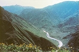
Hells Canyon is a 10 miles (16.1 km) wide canyon
located along the border of eastern Oregon
and western Idaho
in the United States
. It is North America
's deepest river gorge at 7993 feet (2,436.3 m) and part of the Hells Canyon National Recreation Area
.
The canyon was carved by the waters of the Snake River
, which flows more than 1 miles (1.6 km) below the canyon's west rim on the Oregon side and 8000 feet (2,438.4 m) below the peaks of Idaho's Seven Devils Mountains
range to the east. Most of the area is inaccessible by road.
that emerged from the waters of the Pacific Ocean
. Over millions of years, the volcanoes subsided and limestone
built up on the underwater platforms. The basins between them were filled with sedimentary rock
. Between 130 and 17 million years ago, the ocean plate carrying the volcanoes collided with and became part of the North American continent. A period of volcanic activity followed, and much of the area was covered with floods of basalt
lava
, which smoothed the topography
into a high plateau
. The Snake River began carving Hells Canyon out of the plateau about 6 million years ago. Significant canyon-shaping events occurred as recently as 15,000 years ago during a massive outburst flood from Glacial Lake Bonneville
in Utah.
 The earliest known settlers in Hells Canyon were the Nez Percé tribe. Others tribes visiting the area were the Shoshone-Bannock, northern Paiute
and Cayuse
Indians. The mild winters, and ample plant and wildlife attracted human habitation. Pictographs and petroglyph
s on the walls of the canyon are a record of the Indian settlements.
In 1806, three members of the Lewis and Clark Expedition
entered the Hells Canyon region along the Salmon River
. They turned back without seeing the deep parts of the canyon. It was not until 1811 that the Wilson Price Hunt
expedition explored Hells Canyon while seeking a shortcut to the Columbia River
. Hunger and cold forced them to turn back, as did many explorers who were defeated by the canyon's inaccessibility. There remains no evidence in the canyon of their attempts; their expedition journals are the only documentation.
The early miners were next to follow. In the 1860s gold was discovered in river bars near present-day Hells Canyon National Recreation Area, and miners soon penetrated Hells Canyon. Gold mining was not profitable here. Evidence of their endeavors remains visible along the corridor of the Snake River. Later efforts concentrated on hard-rock mining, requiring complex facilities. Evidence of these developments is visible today, especially near the mouth of the Imnaha River
.
In the 1880s there was a short-lived homesteading
boom, but the weather was unsuited to farming and ranching, and settlers soon gave up. However, some ranchers still operate within the boundaries of the National Recreation Area.
 After completion of large hydropower
dams on the Columbia River
in the 1930s through the 1950s, several entities sought approval from the Federal Power Commission
to build dams on the Snake River, including a high dam in Hells Canyon. In 1955, the commission issued a license to the Idaho Power Company
to build a three-dam complex in the canyon. The first of the three, Brownlee Dam
, at river mile
(RM) 285 or river kilometer (RK) 459, was finished in 1958. Oxbow Dam
, 12 miles (19.3 km) downstream, was finished in 1961, and Hells Canyon Dam
, 26 miles (41.8 km) below Oxbow, was completed in 1967. The three dams have a combined generating capacity of 1,167 megawatts (MW) of electricity. The complex, which provides about 70 percent of Idaho's hydroelectricity
, blocks migration of salmon
and other anadromous fish upstream of Hells Canyon Dam.
, Hells Canyon Road follows the Idaho side of the river 22 miles (35.4 km) downstream to the Hells Canyon Dam. The road crosses the dam and continues another mile to the Hells Canyon Visitor Center on the Oregon side. Further north on the Idaho side, Deer Creek Road connects White Bird, Idaho
, to the river at Pittsburg Landing. Near the northern end of the canyon, Forest Road 4260 (Lower Imnaha Road), the last part of which is too rough for most cars, reaches the river at Dug Bar, 21 miles (33.8 km) from Imnaha, Oregon
. On the canyon rims, viewpoints accessible by road include Hat Point and Buckhorn in Oregon and Heavens Gate in Idaho.
Canyon
A canyon or gorge is a deep ravine between cliffs often carved from the landscape by a river. Rivers have a natural tendency to reach a baseline elevation, which is the same elevation as the body of water it will eventually drain into. This forms a canyon. Most canyons were formed by a process of...
located along the border of eastern Oregon
Oregon
Oregon is a state in the Pacific Northwest region of the United States. It is located on the Pacific coast, with Washington to the north, California to the south, Nevada on the southeast and Idaho to the east. The Columbia and Snake rivers delineate much of Oregon's northern and eastern...
and western Idaho
Idaho
Idaho is a state in the Rocky Mountain area of the United States. The state's largest city and capital is Boise. Residents are called "Idahoans". Idaho was admitted to the Union on July 3, 1890, as the 43rd state....
in the United States
United States
The United States of America is a federal constitutional republic comprising fifty states and a federal district...
. It is North America
North America
North America is a continent wholly within the Northern Hemisphere and almost wholly within the Western Hemisphere. It is also considered a northern subcontinent of the Americas...
's deepest river gorge at 7993 feet (2,436.3 m) and part of the Hells Canyon National Recreation Area
Hells Canyon National Recreation Area
Hells Canyon National Recreation Area is a United States National Recreation Area located on the borders of the U.S. states of Oregon and Idaho. The recreation area was established by U.S...
.
The canyon was carved by the waters of the Snake River
Snake River
The Snake is a major river of the greater Pacific Northwest in the United States. At long, it is the largest tributary of the Columbia River, the largest North American river that empties into the Pacific Ocean...
, which flows more than 1 miles (1.6 km) below the canyon's west rim on the Oregon side and 8000 feet (2,438.4 m) below the peaks of Idaho's Seven Devils Mountains
Seven Devils Mountains
The Seven Devils are notable peaks in west central Idaho in the Hells Canyon Wilderness. They are above the east bank of the Snake River, which forms the Idaho-Oregon border. The mountains are part of the Rocky Mountains, and the tallest peaks are 7900 vertical feet above the adjacent Snake...
range to the east. Most of the area is inaccessible by road.
Geology
The geologic history of the rocks of Hells Canyon began 300 million years ago with an arc of volcanoesVolcanic arc
A volcanic arc is a chain of volcanoes positioned in an arc shape as seen from above. Offshore volcanoes form islands, resulting in a volcanic island arc. Generally they result from the subduction of an oceanic tectonic plate under another tectonic plate, and often parallel an oceanic trench...
that emerged from the waters of the Pacific Ocean
Pacific Ocean
The Pacific Ocean is the largest of the Earth's oceanic divisions. It extends from the Arctic in the north to the Southern Ocean in the south, bounded by Asia and Australia in the west, and the Americas in the east.At 165.2 million square kilometres in area, this largest division of the World...
. Over millions of years, the volcanoes subsided and limestone
Limestone
Limestone is a sedimentary rock composed largely of the minerals calcite and aragonite, which are different crystal forms of calcium carbonate . Many limestones are composed from skeletal fragments of marine organisms such as coral or foraminifera....
built up on the underwater platforms. The basins between them were filled with sedimentary rock
Sedimentary rock
Sedimentary rock are types of rock that are formed by the deposition of material at the Earth's surface and within bodies of water. Sedimentation is the collective name for processes that cause mineral and/or organic particles to settle and accumulate or minerals to precipitate from a solution....
. Between 130 and 17 million years ago, the ocean plate carrying the volcanoes collided with and became part of the North American continent. A period of volcanic activity followed, and much of the area was covered with floods of basalt
Basalt
Basalt is a common extrusive volcanic rock. It is usually grey to black and fine-grained due to rapid cooling of lava at the surface of a planet. It may be porphyritic containing larger crystals in a fine matrix, or vesicular, or frothy scoria. Unweathered basalt is black or grey...
lava
Lava
Lava refers both to molten rock expelled by a volcano during an eruption and the resulting rock after solidification and cooling. This molten rock is formed in the interior of some planets, including Earth, and some of their satellites. When first erupted from a volcanic vent, lava is a liquid at...
, which smoothed the topography
Topography
Topography is the study of Earth's surface shape and features or those ofplanets, moons, and asteroids...
into a high plateau
Plateau
In geology and earth science, a plateau , also called a high plain or tableland, is an area of highland, usually consisting of relatively flat terrain. A highly eroded plateau is called a dissected plateau...
. The Snake River began carving Hells Canyon out of the plateau about 6 million years ago. Significant canyon-shaping events occurred as recently as 15,000 years ago during a massive outburst flood from Glacial Lake Bonneville
Lake Bonneville
Lake Bonneville was a prehistoric pluvial lake that covered much of North America's Great Basin region. Most of the territory it covered was in present-day Utah, though parts of the lake extended into present-day Idaho and Nevada. Formed about 32,000 years ago, it existed until about 14,500 years...
in Utah.
History
Paiute
Paiute refers to three closely related groups of Native Americans — the Northern Paiute of California, Idaho, Nevada and Oregon; the Owens Valley Paiute of California and Nevada; and the Southern Paiute of Arizona, southeastern California and Nevada, and Utah.-Origin of name:The origin of...
and Cayuse
Cayuse
The Cayuse are a Native American tribe in the state of Oregon in the United States. The Cayuse tribe shares a reservation in northeastern Oregon with the Umatilla and the Walla Walla tribes as part of the Confederated Tribes of the Umatilla Indian Reservation...
Indians. The mild winters, and ample plant and wildlife attracted human habitation. Pictographs and petroglyph
Petroglyph
Petroglyphs are pictogram and logogram images created by removing part of a rock surface by incising, picking, carving, and abrading. Outside North America, scholars often use terms such as "carving", "engraving", or other descriptions of the technique to refer to such images...
s on the walls of the canyon are a record of the Indian settlements.
In 1806, three members of the Lewis and Clark Expedition
Lewis and Clark Expedition
The Lewis and Clark Expedition, or ″Corps of Discovery Expedition" was the first transcontinental expedition to the Pacific Coast by the United States. Commissioned by President Thomas Jefferson and led by two Virginia-born veterans of Indian wars in the Ohio Valley, Meriwether Lewis and William...
entered the Hells Canyon region along the Salmon River
Salmon River
-United States:There are as many as 17 Salmon Rivers in the United States, the largest of which is:*Salmon River , known as the River of No ReturnOthers include:*Salmon River , Hyder, Alaska*Salmon River...
. They turned back without seeing the deep parts of the canyon. It was not until 1811 that the Wilson Price Hunt
W. Price Hunt
William or Wilson Price Hunt was an early pioneer of the Oregon Country in the Pacific Northwest of North America. An American and an employee of John Jacob Astor, Hunt used information supplied by the Lewis and Clark Expedition to lead the portion of the Astor Expedition that traveled to Oregon...
expedition explored Hells Canyon while seeking a shortcut to the Columbia River
Columbia River
The Columbia River is the largest river in the Pacific Northwest region of North America. The river rises in the Rocky Mountains of British Columbia, Canada, flows northwest and then south into the U.S. state of Washington, then turns west to form most of the border between Washington and the state...
. Hunger and cold forced them to turn back, as did many explorers who were defeated by the canyon's inaccessibility. There remains no evidence in the canyon of their attempts; their expedition journals are the only documentation.
The early miners were next to follow. In the 1860s gold was discovered in river bars near present-day Hells Canyon National Recreation Area, and miners soon penetrated Hells Canyon. Gold mining was not profitable here. Evidence of their endeavors remains visible along the corridor of the Snake River. Later efforts concentrated on hard-rock mining, requiring complex facilities. Evidence of these developments is visible today, especially near the mouth of the Imnaha River
Imnaha River
The Imnaha River is a tributary of the Snake River in the U.S. state of Oregon. Flowing generally east near the headwaters and then north through Wallowa County, the entire river is designated Wild and Scenic...
.
In the 1880s there was a short-lived homesteading
Homesteading
Broadly defined, homesteading is a lifestyle of simple self-sufficiency.-Current practice:The term may apply to anyone who follows the back-to-the-land movement by adopting a sustainable, self-sufficient lifestyle. While land is no longer freely available in most areas of the world, homesteading...
boom, but the weather was unsuited to farming and ranching, and settlers soon gave up. However, some ranchers still operate within the boundaries of the National Recreation Area.
Hydropower
Hydropower, hydraulic power, hydrokinetic power or water power is power that is derived from the force or energy of falling water, which may be harnessed for useful purposes. Since ancient times, hydropower has been used for irrigation and the operation of various mechanical devices, such as...
dams on the Columbia River
Columbia River
The Columbia River is the largest river in the Pacific Northwest region of North America. The river rises in the Rocky Mountains of British Columbia, Canada, flows northwest and then south into the U.S. state of Washington, then turns west to form most of the border between Washington and the state...
in the 1930s through the 1950s, several entities sought approval from the Federal Power Commission
Federal Power Commission
The Federal Power Commission was an independent commission of the United States government, originally organized on June 23, 1930, with five members nominated by the president and confirmed by the Senate...
to build dams on the Snake River, including a high dam in Hells Canyon. In 1955, the commission issued a license to the Idaho Power Company
Idaho Power Company
Idaho Power Company is a regulated electrical power utility. Its business involves the purchase, sale, generation, transmission and distribution of electricity in eastern Oregon and southern Idaho. It is a subsidiary of IDACORP, Inc...
to build a three-dam complex in the canyon. The first of the three, Brownlee Dam
Brownlee Dam
Brownlee Dam is a hydroelectric earth fill embankment dam on the Snake River on the Idaho-Oregon border, in Hells Canyon . It impounds the Snake River in the long Brownlee Reservoir...
, at river mile
River mile
In the United States, a River mile is a measure of distance in miles along a river from its mouth. River mile numbers begin at zero and increase further upstream. The corresponding metric unit using kilometers is the River kilometer...
(RM) 285 or river kilometer (RK) 459, was finished in 1958. Oxbow Dam
Oxbow Dam
Oxbow Dam is a hydroelectric run-of-the-river rockfill dam on the Snake River on the Idaho-Oregon border, in Hells Canyon . It is part of the Hells Canyon Project that also includes Hells Canyon Dam and Brownlee Dam, built and operated by Idaho Power Company.The dam's powerhouse contains four...
, 12 miles (19.3 km) downstream, was finished in 1961, and Hells Canyon Dam
Hells Canyon Dam
Hells Canyon Dam is a concrete gravity dam on the Snake River in Hells Canyon on the Idaho-Oregon border. The dam impounds the Snake River in Hells Canyon Reservoir; its spillway elevation is above sea level....
, 26 miles (41.8 km) below Oxbow, was completed in 1967. The three dams have a combined generating capacity of 1,167 megawatts (MW) of electricity. The complex, which provides about 70 percent of Idaho's hydroelectricity
Hydroelectricity
Hydroelectricity is the term referring to electricity generated by hydropower; the production of electrical power through the use of the gravitational force of falling or flowing water. It is the most widely used form of renewable energy...
, blocks migration of salmon
Salmon
Salmon is the common name for several species of fish in the family Salmonidae. Several other fish in the same family are called trout; the difference is often said to be that salmon migrate and trout are resident, but this distinction does not strictly hold true...
and other anadromous fish upstream of Hells Canyon Dam.
Access
No roads cross Hells Canyon, and only three roads reach the Snake River between Hells Canyon Dam and the Oregon–Washington state boundary further downstream. From Oxbow Bridge near Copperfield, OregonCopperfield, Oregon
Copperfield is a former town in Baker County, Oregon, United States, located on the west bank of the Snake River, near a place called The Oxbow.-Early history:...
, Hells Canyon Road follows the Idaho side of the river 22 miles (35.4 km) downstream to the Hells Canyon Dam. The road crosses the dam and continues another mile to the Hells Canyon Visitor Center on the Oregon side. Further north on the Idaho side, Deer Creek Road connects White Bird, Idaho
White Bird, Idaho
White Bird is a town in Idaho County, Idaho, United States. The population was 106 at the 2000 census.-Geography:White Bird is located at .According to the United States Census Bureau, the city has a total area of , all of it land....
, to the river at Pittsburg Landing. Near the northern end of the canyon, Forest Road 4260 (Lower Imnaha Road), the last part of which is too rough for most cars, reaches the river at Dug Bar, 21 miles (33.8 km) from Imnaha, Oregon
Imnaha, Oregon
Imnaha is an unincorporated community at the confluence of Big Sheep Creek and the Imnaha River in Wallowa County, Oregon, United States. Its elevation is . Oregon Route 350 connects Imnaha to the nearest incorporated city, Joseph, Oregon, to the west....
. On the canyon rims, viewpoints accessible by road include Hat Point and Buckhorn in Oregon and Heavens Gate in Idaho.
Points of interest
| Dug Bar | 45°48′26"N 116°41′22"W | 196 mi 315 km |
1,017 ft 310 m |
Lower Imnaha Road on the Oregon side reaches the Snake at this river bar Bar (river morphology) A bar in a river is an elevated region of sediment that has been deposited by the flow. Types of bars include mid-channel bars , point bars , and mouth bars... . |
| Pittsburg Landing | 45°37′57"N 116°28′31"W | 215 mi 346 km |
1,145 ft 349 m |
Deer Creek Road reaches the river and a United States Forest Service United States Forest Service The United States Forest Service is an agency of the United States Department of Agriculture that administers the nation's 155 national forests and 20 national grasslands, which encompass... campground here, on the Idaho side. |
| Lower end | 45°22′17"N 116°38′18"W | 238 mi 383 km |
1,384 ft 422 m |
Official canyon ends here, according to the Geographic Names Information System Geographic Names Information System The Geographic Names Information System is a database that contains name and locative information about more than two million physical and cultural features located throughout the United States of America and its territories. It is a type of gazetteer... . |
| Hells Canyon Dam Hells Canyon Dam Hells Canyon Dam is a concrete gravity dam on the Snake River in Hells Canyon on the Idaho-Oregon border. The dam impounds the Snake River in Hells Canyon Reservoir; its spillway elevation is above sea level.... |
45°14′30"N 116°42′04"W | 247 mi 398 km |
1,686 ft 514 m |
Furthest downstream in the three-dam Hells Canyon Complex. The only dam in the official canyon. |
| Upper end | 45°09′37"N 116°43′29"W | 254 mi 409 km |
1,688 ft 515 m |
Official canyon begins here, according to the Geographic Names Information System Geographic Names Information System The Geographic Names Information System is a database that contains name and locative information about more than two million physical and cultural features located throughout the United States of America and its territories. It is a type of gazetteer... . |
| Oxbow Dam Oxbow Dam Oxbow Dam is a hydroelectric run-of-the-river rockfill dam on the Snake River on the Idaho-Oregon border, in Hells Canyon . It is part of the Hells Canyon Project that also includes Hells Canyon Dam and Brownlee Dam, built and operated by Idaho Power Company.The dam's powerhouse contains four... |
44°57′55"N 116°50′44"W | 273 mi 439 km |
1,804 ft 550 m |
Middle dam of the three-dam Hells Canyon Complex. Upstream of the official canyon. |
| Brownlee Dam Brownlee Dam Brownlee Dam is a hydroelectric earth fill embankment dam on the Snake River on the Idaho-Oregon border, in Hells Canyon . It impounds the Snake River in the long Brownlee Reservoir... |
44°50′10"N 116°54′04"W | 285 mi 459 km |
2,083 ft 635 m |
Furthest upstream in the three-dam Hells Canyon Complex; not in the official canyon. |
| Hat Point Lookout | 45°26′18"N 116°39′21"W | |
5,784 ft 1,763 m |
Viewpoint on the Oregon side of the canyon rim. |
| Buckhorn Lookout | 45°45′15"N 116°49′22"W | |
5,328 ft 1,624 m |
Viewpoint on the Oregon side of the canyon rim. |
| Kinney Point | 45°09′59"N 116°39′51"W | |
7,083 ft 2,159 m |
Viewpoint on the Idaho side of the canyon rim. |
Works cited
- Orr, Elizabeth L., and Orr, William N. (1999). Geology of Oregon, fifth edition. Dubuque, Iowa: Kendall/Hunt Publishing Company. ISBN 0-7872-6608-6.
- Sullivan, William L. (2002). Exploring Oregon's Wild Areas, third edition. Seattle: The Mountaineers Press. ISBN 0-89886-793-2.
Further reading
- Brooks, Karl Boyd (2009). Public Power, Private Dams: The Hells Canyon High Dam Controversy. Seattle: University of Washington Press. ISBN 978-0-295-98912-9.