
American Falls Dam
Encyclopedia
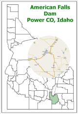
The American Falls Dam is a concrete gravity-type dam
located near the town of American Falls
, Idaho
, on river mile
714.7 of the Snake River
. The dam and reservoir are a part of the Minidoka Project on the Snake River Plain
and are used primarily for flood control, irrigation, and recreation. When the original dam was built by the Bureau of Reclamation
, the residents of American Falls were forced to relocate three-quarters of their town to make room for the reservoir. A second dam was completed in 1978 and the original structure was demolished. Although the dam itself is located in Power County
, its reservoir also stretches northeastward into both Bingham County
and Bannock County
.
dam created a broad shallow lake in the area of the Raft River
during late Pliocene
time, over one million years ago. Much of the basin filled with fine sand, silt, and gravel; then the dam was breached and the lake drained. These sediment
s (called the Raft Formation) lie beneath most of the present-day American Falls Reservoir. At other times the Snake River was dammed completely by basalt
flows extruded from vents. One lava dam a few miles downstream from the present American Falls Dam formed a reservoir in which more than 80 feet (24.4 m) of sediments (clay, silt, and sand) were deposited. This series of basalt flows and original sediments were covered by the new lake bed sediments and are named the Snake River Group and the American Falls Lake Beds. These events occurred up until the late Pleistocene
, less than one million years ago. The Snake River has continued to erode
its channel
in the basalt and modify the lake bed sediments until the present time.
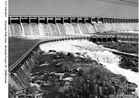
narrows to about 600 ft (180 m) and cascades
about 50 ft (15 m) in several 6–10 ft. drops over highly jointed basalt. The final drop is about a 15 ft (4.6 m) plunge.
 The city of American Falls was first plat
ted in the early 1880s. It was named for the waterfall on the Snake River near the settlement. During the last part of the 19th century, privately financed irrigation canal
s were created to sustain the emerging agriculture industry in southern Idaho and other parts of the west. The Carey act
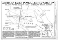
(1894) paved the way for private investment in irrigation projects. By 1895, the American Falls irrigation project came before the Idaho State Land Board. In 1902 the National Reclamation Act
was signed into law and federal funds from the sale of public lands became available to create and maintain irrigation projects in the Western United States. The first power plant was built in 1902 on the falls and was acquired by the Idaho Power Company
in 1916.
Damming the rivers became the preferred method for harnessing the abundant water of the western rivers. The reservoirs could then provide year-round downstream irrigation via canals, even during traditional low water times.
The use of eminent domain
by the government to appropriate the original townsite in 1923 resulted in several lawsuits. One in particular, BROWN v. U S, 263 U.S. 78 (1923) allowed that the property valuation should include the value of the streets and improvements which would need to be replaced in the substitute site.
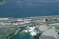
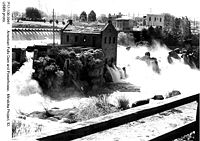 The first dam at American Falls was begun in 1925 by the Bureau of Reclamation and was completed in 1927. The river was temporarily impounded while the new concrete structure was put in place. The Oregon Short Line Railroad
bridge over the river had to be raised to allow for crossing the new reservoir. This dam was designed by Frank A. Banks.
built the dam's current power plant which consists of three generators with a capacity to produce 112,420 kilowatts (112 MW) of hydroelectricity
.
In 1976, the upstream Teton Dam
failed during filling, causing spring snowmelt to race downstream into the Teton River
, a tributary of the Snake, demolishing several towns along its path. In an attempt to contain this flood, water was released from American Falls Dam as quickly as possible. If the dam was to fail, the other Snake River dams would experience a flood they were not designed to cope with, although the lower Columbia River
dams would most likely survive. The American Falls reservoir filled, but its level did not even rise to its spillway
crest.
When the second dam was planned, members of the Shoshone
and Bannock
communities opposed expansion as it would further flood the lands of the Fort Hall Bottoms. Native Americans have inhabited this region for at least 10,000 years and the area is an important resource for them. Many scientists were opposed as well because of the loss of natural habitat and access to fossil records of the Bottoms.
Dam
A dam is a barrier that impounds water or underground streams. Dams generally serve the primary purpose of retaining water, while other structures such as floodgates or levees are used to manage or prevent water flow into specific land regions. Hydropower and pumped-storage hydroelectricity are...
located near the town of American Falls
American Falls, Idaho
American Falls is a city in and the county seat of Power County, Idaho, United States. The population was 4,111 at the 2000 census. It is part of the Pocatello, Idaho Metropolitan Statistical Area.-History:...
, Idaho
Idaho
Idaho is a state in the Rocky Mountain area of the United States. The state's largest city and capital is Boise. Residents are called "Idahoans". Idaho was admitted to the Union on July 3, 1890, as the 43rd state....
, on river mile
River mile
In the United States, a River mile is a measure of distance in miles along a river from its mouth. River mile numbers begin at zero and increase further upstream. The corresponding metric unit using kilometers is the River kilometer...
714.7 of the Snake River
Snake River
The Snake is a major river of the greater Pacific Northwest in the United States. At long, it is the largest tributary of the Columbia River, the largest North American river that empties into the Pacific Ocean...
. The dam and reservoir are a part of the Minidoka Project on the Snake River Plain
Snake River Plain
The Snake River Plain is a geologic feature located primarily within the state of Idaho in the United States of America. It stretches about westward from northwest of the state of Wyoming to the Idaho-Oregon border. The plain is a wide flat bow-shaped depression, and covers about a quarter of Idaho...
and are used primarily for flood control, irrigation, and recreation. When the original dam was built by the Bureau of Reclamation
United States Bureau of Reclamation
The United States Bureau of Reclamation , and formerly the United States Reclamation Service , is an agency under the U.S...
, the residents of American Falls were forced to relocate three-quarters of their town to make room for the reservoir. A second dam was completed in 1978 and the original structure was demolished. Although the dam itself is located in Power County
Power County, Idaho
Power County is a county located in the U.S. state of Idaho. As of the 2000 Census the county had a population of 7,538 ....
, its reservoir also stretches northeastward into both Bingham County
Bingham County, Idaho
Bingham County is a county located in the U.S. state of Idaho. As of the 2000 Census the county had a population of 41,735 . The county seat and largest city is Blackfoot. Bingham County comprises the Blackfoot, ID, Micropolitan Statistical Area.Bingham County was created January 13, 1885, and...
and Bannock County
Bannock County, Idaho
Bannock County is a county located in the southeastern part of the U.S. state of Idaho. It was established in 1893 and named after the local Bannock tribe. It is part of the Pocatello, Idaho Metropolitan Statistical Area, which encompasses all of Bannock and Power counties. As of the 2000 Census...
.
Geology
A lavaLava
Lava refers both to molten rock expelled by a volcano during an eruption and the resulting rock after solidification and cooling. This molten rock is formed in the interior of some planets, including Earth, and some of their satellites. When first erupted from a volcanic vent, lava is a liquid at...
dam created a broad shallow lake in the area of the Raft River
Raft River
The Raft River is a tributary of the Snake River located in northern Utah and southern Idaho in the United States. It is part of the Columbia River Basin.-Course:...
during late Pliocene
Pliocene
The Pliocene Epoch is the period in the geologic timescale that extends from 5.332 million to 2.588 million years before present. It is the second and youngest epoch of the Neogene Period in the Cenozoic Era. The Pliocene follows the Miocene Epoch and is followed by the Pleistocene Epoch...
time, over one million years ago. Much of the basin filled with fine sand, silt, and gravel; then the dam was breached and the lake drained. These sediment
Sediment
Sediment is naturally occurring material that is broken down by processes of weathering and erosion, and is subsequently transported by the action of fluids such as wind, water, or ice, and/or by the force of gravity acting on the particle itself....
s (called the Raft Formation) lie beneath most of the present-day American Falls Reservoir. At other times the Snake River was dammed completely by basalt
Basalt
Basalt is a common extrusive volcanic rock. It is usually grey to black and fine-grained due to rapid cooling of lava at the surface of a planet. It may be porphyritic containing larger crystals in a fine matrix, or vesicular, or frothy scoria. Unweathered basalt is black or grey...
flows extruded from vents. One lava dam a few miles downstream from the present American Falls Dam formed a reservoir in which more than 80 feet (24.4 m) of sediments (clay, silt, and sand) were deposited. This series of basalt flows and original sediments were covered by the new lake bed sediments and are named the Snake River Group and the American Falls Lake Beds. These events occurred up until the late Pleistocene
Pleistocene
The Pleistocene is the epoch from 2,588,000 to 11,700 years BP that spans the world's recent period of repeated glaciations. The name pleistocene is derived from the Greek and ....
, less than one million years ago. The Snake River has continued to erode
Erosion
Erosion is when materials are removed from the surface and changed into something else. It only works by hydraulic actions and transport of solids in the natural environment, and leads to the deposition of these materials elsewhere...
its channel
Channel (geography)
In physical geography, a channel is the physical confine of a river, slough or ocean strait consisting of a bed and banks.A channel is also the natural or human-made deeper course through a reef, sand bar, bay, or any shallow body of water...
in the basalt and modify the lake bed sediments until the present time.
Geography
The dam at American Falls is on the Snake River Plain at an elevation of 4357/1328 (ft/m). The topography in the immediate vicinity of the river is gently rolling, with differences in elevation of less than 200 ft (60 m). The original falls occur where the river channelChannel (geography)
In physical geography, a channel is the physical confine of a river, slough or ocean strait consisting of a bed and banks.A channel is also the natural or human-made deeper course through a reef, sand bar, bay, or any shallow body of water...
narrows to about 600 ft (180 m) and cascades
Waterfall
A waterfall is a place where flowing water rapidly drops in elevation as it flows over a steep region or a cliff.-Formation:Waterfalls are commonly formed when a river is young. At these times the channel is often narrow and deep. When the river courses over resistant bedrock, erosion happens...
about 50 ft (15 m) in several 6–10 ft. drops over highly jointed basalt. The final drop is about a 15 ft (4.6 m) plunge.
1880-1925
Plat
A plat in the U.S. is a map, drawn to scale, showing the divisions of a piece of land. Other English-speaking countries generally call such documents a cadastral map or plan....
ted in the early 1880s. It was named for the waterfall on the Snake River near the settlement. During the last part of the 19th century, privately financed irrigation canal
Canal
Canals are man-made channels for water. There are two types of canal:#Waterways: navigable transportation canals used for carrying ships and boats shipping goods and conveying people, further subdivided into two kinds:...
s were created to sustain the emerging agriculture industry in southern Idaho and other parts of the west. The Carey act
Carey act
The Carey Act of 1894 allowed private companies in the U.S. to erect irrigation systems in the western semi-arid states, and profit from the sales of water. The Carey Act was enacted into law by Congress by the Act of August 18, 1894 , as amended...
(1894) paved the way for private investment in irrigation projects. By 1895, the American Falls irrigation project came before the Idaho State Land Board. In 1902 the National Reclamation Act
Newlands Reclamation Act
The Reclamation Act of 1902 is a United States federal law that funded irrigation projects for the arid lands of 20 states in the American West....
was signed into law and federal funds from the sale of public lands became available to create and maintain irrigation projects in the Western United States. The first power plant was built in 1902 on the falls and was acquired by the Idaho Power Company
Idaho Power Company
Idaho Power Company is a regulated electrical power utility. Its business involves the purchase, sale, generation, transmission and distribution of electricity in eastern Oregon and southern Idaho. It is a subsidiary of IDACORP, Inc...
in 1916.
Damming the rivers became the preferred method for harnessing the abundant water of the western rivers. The reservoirs could then provide year-round downstream irrigation via canals, even during traditional low water times.
The use of eminent domain
Eminent domain
Eminent domain , compulsory purchase , resumption/compulsory acquisition , or expropriation is an action of the state to seize a citizen's private property, expropriate property, or seize a citizen's rights in property with due monetary compensation, but without the owner's consent...
by the government to appropriate the original townsite in 1923 resulted in several lawsuits. One in particular, BROWN v. U S, 263 U.S. 78 (1923) allowed that the property valuation should include the value of the streets and improvements which would need to be replaced in the substitute site.
1925-1960
Oregon Short Line Railroad
The Oregon Short Line Railroad was a railroad in the U.S. states of Wyoming, Idaho, Utah, Montana and Oregon. The line was as organized the Oregon Short Line Railway in 1881 as a subsidiary of Union Pacific Railway. Union Pacific intended the line to be the shortest route from Wyoming to Oregon...
bridge over the river had to be raised to allow for crossing the new reservoir. This dam was designed by Frank A. Banks.
1960-1978
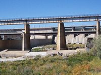
The existing dam is the second structure to be called the American Falls Dam. Core samples taken in the early 1960's of the concrete of the original structure revealed deterioration resulting in impaired durability and strength caused by a chemical reaction between components of the concrete. The solution was to replace the original dam with a second dam built downstream in 1978. Replacement of the original dam was authorized by a congressional act of December 28, 1973 (87 Stat. 904, Public Law 93-206). In 1976, the Idaho Power CompanyIdaho Power Company
Idaho Power Company is a regulated electrical power utility. Its business involves the purchase, sale, generation, transmission and distribution of electricity in eastern Oregon and southern Idaho. It is a subsidiary of IDACORP, Inc...
built the dam's current power plant which consists of three generators with a capacity to produce 112,420 kilowatts (112 MW) of hydroelectricity
Hydroelectricity
Hydroelectricity is the term referring to electricity generated by hydropower; the production of electrical power through the use of the gravitational force of falling or flowing water. It is the most widely used form of renewable energy...
.
In 1976, the upstream Teton Dam
Teton Dam
The Teton Dam was a federally built earthen dam on the Teton River in southeastern Idaho, set between Fremont and Madison counties, USA, which when filling for the first time suffered a catastrophic failure on June 5, 1976. The collapse of the dam resulted in the deaths of 11 peopleand 13,000 head...
failed during filling, causing spring snowmelt to race downstream into the Teton River
Teton River (Idaho)
The Teton River is an tributary of the Henrys Fork of the Snake River in southeastern Idaho in the United States. It drains through the Teton Valley along the west side of the Teton Range along the Idaho-Wyoming border at the eastern end of the Snake River Plain...
, a tributary of the Snake, demolishing several towns along its path. In an attempt to contain this flood, water was released from American Falls Dam as quickly as possible. If the dam was to fail, the other Snake River dams would experience a flood they were not designed to cope with, although the lower Columbia River
Columbia River
The Columbia River is the largest river in the Pacific Northwest region of North America. The river rises in the Rocky Mountains of British Columbia, Canada, flows northwest and then south into the U.S. state of Washington, then turns west to form most of the border between Washington and the state...
dams would most likely survive. The American Falls reservoir filled, but its level did not even rise to its spillway
Spillway
A spillway is a structure used to provide the controlled release of flows from a dam or levee into a downstream area, typically being the river that was dammed. In the UK they may be known as overflow channels. Spillways release floods so that the water does not overtop and damage or even destroy...
crest.
When the second dam was planned, members of the Shoshone
Shoshone
The Shoshone or Shoshoni are a Native American tribe in the United States with three large divisions: the Northern, the Western and the Eastern....
and Bannock
Bannock (tribe)
The Bannock tribe of the Northern Paiute are an indigenous people of the Great Basin. Their traditional lands include southeastern Oregon, southeastern Idaho, western Wyoming, and southwestern Montana...
communities opposed expansion as it would further flood the lands of the Fort Hall Bottoms. Native Americans have inhabited this region for at least 10,000 years and the area is an important resource for them. Many scientists were opposed as well because of the loss of natural habitat and access to fossil records of the Bottoms.
External links