

Rock formation
Encyclopedia
Rock (geology)
In geology, rock or stone is a naturally occurring solid aggregate of minerals and/or mineraloids.The Earth's outer solid layer, the lithosphere, is made of rock. In general rocks are of three types, namely, igneous, sedimentary, and metamorphic...
outcrops. These formations are usually the result of weathering
Weathering
Weathering is the breaking down of rocks, soils and minerals as well as artificial materials through contact with the Earth's atmosphere, biota and waters...
and erosion
Erosion
Erosion is when materials are removed from the surface and changed into something else. It only works by hydraulic actions and transport of solids in the natural environment, and leads to the deposition of these materials elsewhere...
sculpting the existing rock. The term 'rock formation' can also refer to specific sedimentary strata
Stratum
In geology and related fields, a stratum is a layer of sedimentary rock or soil with internally consistent characteristics that distinguish it from other layers...
or other rock unit in stratigraphic
Stratigraphy
Stratigraphy, a branch of geology, studies rock layers and layering . It is primarily used in the study of sedimentary and layered volcanic rocks....
and petrologic
Petrology
Petrology is the branch of geology that studies rocks, and the conditions in which rocks form....
studies.
A rock structure can be created in any rock type or combination:
- Sedimentary rockSedimentary rockSedimentary rock are types of rock that are formed by the deposition of material at the Earth's surface and within bodies of water. Sedimentation is the collective name for processes that cause mineral and/or organic particles to settle and accumulate or minerals to precipitate from a solution....
s are created by a variety of processes but usually involving deposition, grain by grain, layer by layer, in water or, in the case of terrestrial sediments, on land through the action of wind or sometimes moving ice. ErosionErosionErosion is when materials are removed from the surface and changed into something else. It only works by hydraulic actions and transport of solids in the natural environment, and leads to the deposition of these materials elsewhere...
later exposes them in their current form. An example is Bryce Canyon National ParkBryce Canyon National ParkBryce Canyon National Park is a national park located in southwestern Utah in the United States. The major feature of the park is Bryce Canyon which, despite its name, is not a canyon but a giant natural amphitheater created by erosion along the eastern side of the Paunsaugunt Plateau...
in UtahUtahUtah is a state in the Western United States. It was the 45th state to join the Union, on January 4, 1896. Approximately 80% of Utah's 2,763,885 people live along the Wasatch Front, centering on Salt Lake City. This leaves vast expanses of the state nearly uninhabited, making the population the...
. - Metamorphic rocks are created by rocks that have been transformed into another kind of rock, usually by some combination of heat, pressure and chemical alteration. An example are the Seneca RocksSeneca RocksSeneca Rocks is a large crag and local landmark in Pendleton County in the Eastern Panhandle of West Virginia, USA. It is easily visible and accessible along West Virginia Route 28 near U.S. Route 33 in the Spruce Knob-Seneca Rocks National Recreation Area of the Monongahela National Forest...
in West VirginiaWest VirginiaWest Virginia is a state in the Appalachian and Southeastern regions of the United States, bordered by Virginia to the southeast, Kentucky to the southwest, Ohio to the northwest, Pennsylvania to the northeast and Maryland to the east...
. - Igneous rocks are created when molten rock cools and solidifies, with or without crystallization. They may be either plutonic bodies or volcanic extrusives. Again, erosive forces sculpt their current forms. An example is Half DomeHalf DomeHalf Dome is a granite dome in Yosemite National Park, located in northeastern Mariposa County, California, at the eastern end of Yosemite Valley — possibly Yosemite's most familiar rock formation. The granite crest rises more than above the valley floor....
in Yosemite National ParkYosemite National ParkYosemite National Park is a United States National Park spanning eastern portions of Tuolumne, Mariposa and Madera counties in east central California, United States. The park covers an area of and reaches across the western slopes of the Sierra Nevada mountain chain...
.
Geologists have created a number of terms to describe different rock structures in the landscape
Landscape
Landscape comprises the visible features of an area of land, including the physical elements of landforms such as mountains, hills, water bodies such as rivers, lakes, ponds and the sea, living elements of land cover including indigenous vegetation, human elements including different forms of...
that can be formed by natural processes:
- Inselberg is a residual relief feature. It can be an isolated hill, a knob, ridge or small mountain that rises abruptly, like an island, from a gently sloping or virtually level surrounding plain. Inselberg is a German word that means "island mountain". UluruUluruUluru , also known as Ayers Rock, is a large sandstone rock formation in the southern part of the Northern Territory, central Australia. It lies south west of the nearest large town, Alice Springs; by road. Kata Tjuta and Uluru are the two major features of the Uluṟu-Kata Tjuṯa National Park....
/Ayers Rock in AustraliaAustraliaAustralia , officially the Commonwealth of Australia, is a country in the Southern Hemisphere comprising the mainland of the Australian continent, the island of Tasmania, and numerous smaller islands in the Indian and Pacific Oceans. It is the world's sixth-largest country by total area...
is a noted example. - PeakPyramidal peakA pyramidal peak, or sometimes in its most extreme form called a glacial horn, is a mountaintop that has been modified by the action of ice during glaciation and frost weathering...
- StackStack (geology)A stack is a geological landform consisting of a steep and often vertical column or columns of rock in the sea near a coast, isolated by erosion. Stacks are formed through processes of coastal geomorphology, which are entirely natural. Time, wind and water are the only factors involved in the...
- MesaMesaA mesa or table mountain is an elevated area of land with a flat top and sides that are usually steep cliffs. It takes its name from its characteristic table-top shape....
- ButteButteA butte is a conspicuous isolated hill with steep, often vertical sides and a small, relatively flat top; it is smaller than mesas, plateaus, and table landform tables. In some regions, such as the north central and northwestern United States, the word is used for any hill...
- EscarpmentEscarpmentAn escarpment is a steep slope or long cliff that occurs from erosion or faulting and separates two relatively level areas of differing elevations.-Description and variants:...
- Gorge
- Sea cliff
- River cliff
- Stone runStone runA stone run is a conspicuous rock landform, result of the erosion of particular rock varieties caused by myriad freezing-thawing cycles taking place in periglacial conditions during the last Ice Age.The actual formation of stone runs involved no less than five processes: weathering, solifluction,...
- CragCliffIn geography and geology, a cliff is a significant vertical, or near vertical, rock exposure. Cliffs are formed as erosion landforms due to the processes of erosion and weathering that produce them. Cliffs are common on coasts, in mountainous areas, escarpments and along rivers. Cliffs are usually...
- Tor
- PromontoryPromontoryPromontory may refer to:*Promontory, a prominent mass of land which overlooks lower lying land or a body of water*Promontory, Utah, the location where the United States first Transcontinental Railroad was completed...
is a prominent mass of land which overlooks lower lying land or a body of water.
Asia
- Biri Islands, Northern SamarNorthern SamarNorthern Samar is a province of the Philippines located in the Eastern Visayas region. Its capital is Catarman and is located at the northern portion of the island of Samar. Bordering the province to the south are the provinces of Samar and Eastern Samar...
, PhilippinesPhilippinesThe Philippines , officially known as the Republic of the Philippines , is a country in Southeast Asia in the western Pacific Ocean. To its north across the Luzon Strait lies Taiwan. West across the South China Sea sits Vietnam... - Yoichi, HokkaidōHokkaido, formerly known as Ezo, Yezo, Yeso, or Yesso, is Japan's second largest island; it is also the largest and northernmost of Japan's 47 prefectural-level subdivisions. The Tsugaru Strait separates Hokkaido from Honshu, although the two islands are connected by the underwater railway Seikan Tunnel...
, JapanJapanJapan is an island nation in East Asia. Located in the Pacific Ocean, it lies to the east of the Sea of Japan, China, North Korea, South Korea and Russia, stretching from the Sea of Okhotsk in the north to the East China Sea and Taiwan in the south... - YehliuYehliuYehliu is a cape on the north coast of Taiwan in the town of Wanli between Taipei and Keelung.The cape, known by geologists as the Yehliu Promontory, forms part of the Taliao Miocene Formation...
, TaiwanTaiwanTaiwan , also known, especially in the past, as Formosa , is the largest island of the same-named island group of East Asia in the western Pacific Ocean and located off the southeastern coast of mainland China. The island forms over 99% of the current territory of the Republic of China following... - Kyaiktiyo PagodaKyaiktiyo PagodaKyaiktiyo Pagoda , also known as Golden Rock) is a well-known Buddhist pilgrimage site in Mon State, Myanmar. It is a small pagoda built on the top of a granite boulder covered with gold leaves pasted on by devotees. According to legend, the Golden Rock itself is precariously perched on a strand...
, Mon StateMon StateMon State is an administrative division of Myanmar. It is sandwiched between Kayin State on the east, the Andaman Sea on the west, Bago Region on the north and Tanintharyi Region on the south, and has a short border with Thailand's Kanchanaburi Province at its south-eastern tip. The land area is...
, Burma - Tanjong Bunga, PenangPenangPenang is a state in Malaysia and the name of its constituent island, located on the northwest coast of Peninsular Malaysia by the Strait of Malacca. It is bordered by Kedah in the north and east, and Perak in the south. Penang is the second smallest Malaysian state in area after Perlis, and the...
, Malaysia - Jabalpur Marble Rocks, Madhya PradeshMadhya PradeshMadhya Pradesh , often called the Heart of India, is a state in central India. Its capital is Bhopal and Indore is the largest city....
, IndiaIndiaIndia , officially the Republic of India , is a country in South Asia. It is the seventh-largest country by geographical area, the second-most populous country with over 1.2 billion people, and the most populous democracy in the world... - Face Rock, Deccan, Hyderabad, India
- Sitio Lugsangan, Barangay Tabon, Cebu, PhilippinesPhilippinesThe Philippines , officially known as the Republic of the Philippines , is a country in Southeast Asia in the western Pacific Ocean. To its north across the Luzon Strait lies Taiwan. West across the South China Sea sits Vietnam...
- Amah RockAmah RockAmah Rock is a naturally occurring rock located on a hilltop in southwest Sha Tin, Hong Kong. The rock is approximately 15 meters in height, and its shape looks like a woman carrying a baby on her back...
, Hong KongHong KongHong Kong is one of two Special Administrative Regions of the People's Republic of China , the other being Macau. A city-state situated on China's south coast and enclosed by the Pearl River Delta and South China Sea, it is renowned for its expansive skyline and deep natural harbour... - Yun Meng Mountains, BeijingBeijingBeijing , also known as Peking , is the capital of the People's Republic of China and one of the most populous cities in the world, with a population of 19,612,368 as of 2010. The city is the country's political, cultural, and educational center, and home to the headquarters for most of China's...
, ChinaChinaChinese civilization may refer to:* China for more general discussion of the country.* Chinese culture* Greater China, the transnational community of ethnic Chinese.* History of China* Sinosphere, the area historically affected by Chinese culture... - GuilinGuilinGuilin is a prefecture-level city in the northeast of the Guangxi Zhuang Autonomous Region of far southern China, sitting on the west bank of the Li River. Its name means "forest of Sweet Osmanthus", owing to the large number of fragrant Sweet Osmanthus trees located in the city...
, China - Grandfather and Grandmother stone, Ko SamuiKo SamuiKo Samui island of Surat Thani Province , or often, simply Samui as it is referred to by locals, is an island off the east coast of the Kra Isthmus in Thailand, close to the mainland Surat Thani town. It is Thailand's second largest island, with an area of 228.7 km2 and a population of over...
, ThailandThailandThailand , officially the Kingdom of Thailand , formerly known as Siam , is a country located at the centre of the Indochina peninsula and Southeast Asia. It is bordered to the north by Burma and Laos, to the east by Laos and Cambodia, to the south by the Gulf of Thailand and Malaysia, and to the... - James Bond Island, Phang NgaPhang Nga ProvincePhang Nga is one of the southern provinces of Thailand, on the shore to the Andaman Sea. Neighboring provinces are Ranong, Surat Thani and Krabi. To the south is the Phuket province, but without land boundary to Phang Nga....
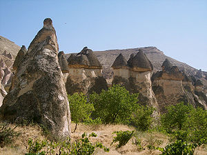
, Thailand - Paşabağı, CappadociaCappadociaCappadocia is a historical region in Central Anatolia, largely in Nevşehir Province.In the time of Herodotus, the Cappadocians were reported as occupying the whole region from Mount Taurus to the vicinity of the Euxine...
, TurkeyTurkeyTurkey , known officially as the Republic of Turkey , is a Eurasian country located in Western Asia and in East Thrace in Southeastern Europe... - Goreme National Park, Turkey
- Halong BayHalong BayHa Long Bay is a UNESCO World Heritage Site, and a popular travel destination, located in Quang Ninh province, Vietnam. Administratively, the bay belongs to Hạ Long City, Cẩm Phả town, and part of Van Don district. The bay features thousands of limestone karsts and isles in various sizes and shapes...
, VietnamVietnamVietnam – sometimes spelled Viet Nam , officially the Socialist Republic of Vietnam – is the easternmost country on the Indochina Peninsula in Southeast Asia. It is bordered by China to the north, Laos to the northwest, Cambodia to the southwest, and the South China Sea –... - Long Ya MenLong Ya MenLong Ya Men or Dragon's Teeth Gate, a craggy granite outcrop, formerly stood at the gateway to Keppel Harbour in Singapore. The Long Ya Men served as navigational aids to ancient mariners sailing through the swift waters of the narrow channel between them...
, SingaporeSingaporeSingapore , officially the Republic of Singapore, is a Southeast Asian city-state off the southern tip of the Malay Peninsula, north of the equator. An island country made up of 63 islands, it is separated from Malaysia by the Straits of Johor to its north and from Indonesia's Riau Islands by the... - Seorak-san National Park, SokchoSokchoSokcho is a city in Gangwon-do province, South Korea. It is located in the far northeast of Gangwon-do. Lying north of the 38th parallel, the city belonged to North Korea from 1945 until the end of the Korean War, when the dividing line between the two Korean states was officially altered....
, South KoreaSouth KoreaThe Republic of Korea , , is a sovereign state in East Asia, located on the southern portion of the Korean Peninsula. It is neighbored by the People's Republic of China to the west, Japan to the east, North Korea to the north, and the East China Sea and Republic of China to the south... - Taichar Chuluu, Arkhangai Aimag, MongoliaMongoliaMongolia is a landlocked country in East and Central Asia. It is bordered by Russia to the north and China to the south, east and west. Although Mongolia does not share a border with Kazakhstan, its western-most point is only from Kazakhstan's eastern tip. Ulan Bator, the capital and largest...
- Turtle Rock, Gorkhi-Terelj National ParkGorkhi-Terelj National ParkGorkhi-Terelj National Park is one of the national parks of Mongolia. The Terelj tourist zone has a number of "tourist camps" . It is connected with Ulan Bator by a paved road...
, Töv AimagTöv ProvinceTöv is one of the 21 aimags of Mongolia. The national capital Ulaanbaatar is located roughly at its center, but the city itself is administrated as an independent municipality.- Geography :...
/NalaikhNalaikhNalaikh is one of nine Düüregs of the Mongolian capital of Ulaanbaatar. It is subdivided into 6 Khoroos .Other than most other düüregs, Nalaikh is technically a separate city, but still under the common administration of the capital....
, MongoliaMongoliaMongolia is a landlocked country in East and Central Asia. It is bordered by Russia to the north and China to the south, east and west. Although Mongolia does not share a border with Kazakhstan, its western-most point is only from Kazakhstan's eastern tip. Ulan Bator, the capital and largest... - Tanah LotTanah LotTanah Lot is a rock formation off the Indonesian island of Bali. It is home of a pilgrimage temple, the Pura Tanah Lot and a popular tourist and cultural icon for photography and general exoticism.- History :...
, BaliBaliBali is an Indonesian island located in the westernmost end of the Lesser Sunda Islands, lying between Java to the west and Lombok to the east...
, IndonesiaIndonesiaIndonesia , officially the Republic of Indonesia , is a country in Southeast Asia and Oceania. Indonesia is an archipelago comprising approximately 13,000 islands. It has 33 provinces with over 238 million people, and is the world's fourth most populous country. Indonesia is a republic, with an... - Jeti-ÖgüzJeti-Ögüz RocksThe Jeti-Ögüz Rocks is a geological protected area located in Jeti-Oguz District of Issyk-Kul Province of Kyrgyzstan. It was established in 1975 with a purpose of conservation of a unique geological formation - sheer cliffs composed of tertiary red conglomerates...
, Jeti-Ögüz districtJeti-Oguz DistrictJeti-Oguz or Jeti-Ögüz is a raion of Issyk Kul Province in north-eastern Kyrgyzstan. The capital lies at Kyzyl-Suu.-Towns and villages:...
, KyrgyzstanKyrgyzstanKyrgyzstan , officially the Kyrgyz Republic is one of the world's six independent Turkic states . Located in Central Asia, landlocked and mountainous, Kyrgyzstan is bordered by Kazakhstan to the north, Uzbekistan to the west, Tajikistan to the southwest and China to the east... - Yonaguni MonumentYonaguni MonumentThe Yonaguni Monument is a massive underwater rock formation off the coast of Yonaguni, the southernmost of the Ryukyu Islands, in Japan. There is a debate about whether the site is completely natural, is a natural site that has been modified, or is a manmade artifact.The site is variably referred...
, the coast of YonaguniYonaguniis one of the Yaeyama Islands. It is the westernmost inhabited island of Japan and lies from the east coast of Taiwan, between the East China Sea and the Pacific Ocean proper....
, JapanJapanJapan is an island nation in East Asia. Located in the Pacific Ocean, it lies to the east of the Sea of Japan, China, North Korea, South Korea and Russia, stretching from the Sea of Okhotsk in the north to the East China Sea and Taiwan in the south...
- Lion RockLion RockLion Rock, or less formally Lion Rock Hill, is a famous hill in Hong Kong. It is located between Kowloon Tong in Kowloon and Tai Wai in the New Territories, and is 495 metres high...
, New Kowloon/New Territories, Hong Kong
Middle East
- Rosh HanikraRosh Hanikra grottoesRosh HaNikra is a geologic formation in Israel, located on the coast of the Mediterranean Sea, in the Western Galilee. It is a white chalk cliff face which opens up into spectacular grottos....
, IsraelIsraelThe State of Israel is a parliamentary republic located in the Middle East, along the eastern shore of the Mediterranean Sea... - Timna Arch, Eilat, IsraelIsraelThe State of Israel is a parliamentary republic located in the Middle East, along the eastern shore of the Mediterranean Sea...
- Karnei Hittim, Israel
- Tegherivank, ArmeniaArmeniaArmenia , officially the Republic of Armenia , is a landlocked mountainous country in the Caucasus region of Eurasia...
- GeghardGeghardFor the town, see Geghard, Armenia.The monastery of Geghard is a unique architectural construction in the Kotayk province of Armenia, being partially carved out of the adjacent mountain, surrounded by cliffs...
, Armenia - PetraPetraPetra is a historical and archaeological city in the Jordanian governorate of Ma'an that is famous for its rock cut architecture and water conduits system. Established sometime around the 6th century BC as the capital city of the Nabataeans, it is a symbol of Jordan as well as its most visited...
, AmmanAmmanAmman is the capital of Jordan. It is the country's political, cultural and commercial centre and one of the oldest continuously inhabited cities in the world. The Greater Amman area has a population of 2,842,629 as of 2010. The population of Amman is expected to jump from 2.8 million to almost...
, JordanJordanJordan , officially the Hashemite Kingdom of Jordan , Al-Mamlaka al-Urduniyya al-Hashemiyya) is a kingdom on the East Bank of the River Jordan. The country borders Saudi Arabia to the east and south-east, Iraq to the north-east, Syria to the north and the West Bank and Israel to the west, sharing... - Wadi Rum DesertWadi RumWadi Rum also known as The Valley of the Moon is a valley cut into the sandstone and granite rock in south Jordan at to the east of Aqaba. It is the largest wadi in Jordan. The name Rum most likely comes from an Aramaic root meaning 'high' or 'elevated'. To reflect its proper Arabic...
, Jordan - Kuh-E-Namak, IranIranIran , officially the Islamic Republic of Iran , is a country in Southern and Western Asia. The name "Iran" has been in use natively since the Sassanian era and came into use internationally in 1935, before which the country was known to the Western world as Persia...
- Elemite Rock, Fars, Iran
- Mahneshan, Zanjan, Iran
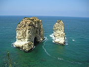
- Cape Lithoprosopon, LebanonLebanonLebanon , officially the Republic of LebanonRepublic of Lebanon is the most common term used by Lebanese government agencies. The term Lebanese Republic, a literal translation of the official Arabic and French names that is not used in today's world. Arabic is the most common language spoken among...
- RaouchéRaouchéRaouché is a residential and commercial neighborhood in Beirut, Lebanon. It is known for its upscale apartment buildings, numerous restaurants, and cliff-side cafés that line Avenue de Paris, which forms part of the Corniche Beirut...
, BeirutBeirutBeirut is the capital and largest city of Lebanon, with a population ranging from 1 million to more than 2 million . Located on a peninsula at the midpoint of Lebanon's Mediterranean coastline, it serves as the country's largest and main seaport, and also forms the Beirut Metropolitan...
, Lebanon - Gobustan, AzerbaijanAzerbaijanAzerbaijan , officially the Republic of Azerbaijan is the largest country in the Caucasus region of Eurasia. Located at the crossroads of Western Asia and Eastern Europe, it is bounded by the Caspian Sea to the east, Russia to the north, Georgia to the northwest, Armenia to the west, and Iran to...
- Aphrodite's Rock, PaphosPaphosPaphos , sometimes referred to as Pafos, is a coastal city in the southwest of Cyprus and the capital of Paphos District. In antiquity, two locations were called Paphos: Old Paphos and New Paphos. The currently inhabited city is New Paphos. It lies on the Mediterranean coast, about west of the...
, CyprusCyprusCyprus , officially the Republic of Cyprus , is a Eurasian island country, member of the European Union, in the Eastern Mediterranean, east of Greece, south of Turkey, west of Syria and north of Egypt. It is the third largest island in the Mediterranean Sea.The earliest known human activity on the... - Wadi Dhar, YemenYemenThe Republic of Yemen , commonly known as Yemen , is a country located in the Middle East, occupying the southwestern to southern end of the Arabian Peninsula. It is bordered by Saudi Arabia to the north, the Red Sea to the west, and Oman to the east....
- Bani Al Harit, Saana, Yemen
South Africa
- Cedarberg Wilderness Area, Western Cape
- Kagga Kamma, Ceres, Western Cape
- Three Sisters (Northern Cape)
Canada
- Agawa Bay, Lake SuperiorLake SuperiorLake Superior is the largest of the five traditionally-demarcated Great Lakes of North America. It is bounded to the north by the Canadian province of Ontario and the U.S. state of Minnesota, and to the south by the U.S. states of Wisconsin and Michigan. It is the largest freshwater lake in the...
- Grand Manan Island, New BrunswickNew BrunswickNew Brunswick is one of Canada's three Maritime provinces and is the only province in the federation that is constitutionally bilingual . The provincial capital is Fredericton and Saint John is the most populous city. Greater Moncton is the largest Census Metropolitan Area...
- Hopewell RocksHopewell RocksThe Hopewell Rocks, also called the Flowerpot Rocks or simply The Rocks, are rock formations caused by tidal erosion in The Hopewell Rocks Ocean Tidal Exploration Site in New Brunswick....
, New BrunswickNew BrunswickNew Brunswick is one of Canada's three Maritime provinces and is the only province in the federation that is constitutionally bilingual . The provincial capital is Fredericton and Saint John is the most populous city. Greater Moncton is the largest Census Metropolitan Area... - Gabriola IslandGabriola IslandGabriola Island is one of the Gulf Islands in the Strait of Georgia, in British Columbia , Canada. Gabriola lies about east of Nanaimo on Vancouver Island, to which it is linked by ferry...
, British ColumbiaBritish ColumbiaBritish Columbia is the westernmost of Canada's provinces and is known for its natural beauty, as reflected in its Latin motto, Splendor sine occasu . Its name was chosen by Queen Victoria in 1858... - Brady's Beach, Bamfield, British ColumbiaBamfield, British ColumbiaBamfield is a community that is surrounded by Crown Land, Indian Reserves, and portions of the Pacific Rim National Park, located on Barkley Sound, Vancouver Island in British Columbia. The community, with a population of 251 as of 2006, is divided by Bamfield Inlet.- History :Bamfield is populated...
- Chimney RockChimney Rock (Canada)Chimney Rock is a limestone formation in Marble Canyon, British Columbia, Canada. According to a First Nations legend, it was created by the actions of the Transformers, a group of supernatural beings who traveled around the country putting things to right by changing things into stone....
, Marble CanyonMarble Canyon (British Columbia)Marble Canyon is a small canyon in the south-central Interior of British Columbia, Canada a few kilometres east of the Fraser River and the community of Pavilion, British Columbia, approximately midway between the towns of Lillooet and Cache Creek. A collapsed karst formation, the canyon's name...
, British ColumbiaBritish ColumbiaBritish Columbia is the westernmost of Canada's provinces and is known for its natural beauty, as reflected in its Latin motto, Splendor sine occasu . Its name was chosen by Queen Victoria in 1858... - Heron Rocks, Hornby Island, British ColumbiaBritish ColumbiaBritish Columbia is the westernmost of Canada's provinces and is known for its natural beauty, as reflected in its Latin motto, Splendor sine occasu . Its name was chosen by Queen Victoria in 1858...
- Percé RockPercé RockPercé Rock is a huge sheer rock formation in the Gulf of Saint Lawrence on the tip of the Gaspé Peninsula in Quebec, Canada, off Percé Bay. Percé Rock appears from a distance like a ship under sail. It is one of the world's largest natural arches located in water and is considered a natural icon...
, Gaspé, QuebecQuebecQuebec or is a province in east-central Canada. It is the only Canadian province with a predominantly French-speaking population and the only one whose sole official language is French at the provincial level.... - Tete d'Indien, Perce, Gaspé, QuebecQuebecQuebec or is a province in east-central Canada. It is the only Canadian province with a predominantly French-speaking population and the only one whose sole official language is French at the provincial level....
- Balancing RockBalancing rockA balancing rock, also called balanced rock or precarious boulder, is a naturally occurring geological formation featuring a large rock or boulder, sometimes of substantial size, resting on other rocks, bedrock or on glacial till. Some formations known by this name only appear to be balancing but...
, Long Island, Nova ScotiaNova ScotiaNova Scotia is one of Canada's three Maritime provinces and is the most populous province in Atlantic Canada. The name of the province is Latin for "New Scotland," but "Nova Scotia" is the recognized, English-language name of the province. The provincial capital is Halifax. Nova Scotia is the... - Peggys Cove, Nova ScotiaPeggys Cove, Nova ScotiaPeggys Cove is one of the busiest tourist attractions in Nova Scotia and is a prime attraction on the Lighthouse Trail scenic drive. The community's famous lighthouse marks the eastern entrance of St. Margarets Bay and is officially known as the Peggys Point Lighthouse.Peggys Cove has a classic...
- Banff National ParkBanff National ParkBanff National Park is Canada's oldest national park, established in 1885 in the Rocky Mountains. The park, located 110–180 kilometres west of Calgary in the province of Alberta, encompasses of mountainous terrain, with numerous glaciers and ice fields, dense coniferous forest, and alpine...
, AlbertaAlbertaAlberta is a province of Canada. It had an estimated population of 3.7 million in 2010 making it the most populous of Canada's three prairie provinces... - Drumheller, AlbertaDrumheller, AlbertaDrumheller is a town within the Red Deer River valley in the badlands of east-central Alberta, Canada. It is located northeast of Calgary...
- Main Topsail Hill, near Gaff Topsails, Newfoundland and LabradorNewfoundland and LabradorNewfoundland and Labrador is the easternmost province of Canada. Situated in the country's Atlantic region, it incorporates the island of Newfoundland and mainland Labrador with a combined area of . As of April 2011, the province's estimated population is 508,400...
- Arches, St. Anthony, Newfoundland and LabradorNewfoundland and LabradorNewfoundland and Labrador is the easternmost province of Canada. Situated in the country's Atlantic region, it incorporates the island of Newfoundland and mainland Labrador with a combined area of . As of April 2011, the province's estimated population is 508,400...
- Elephant Rock, Prince Edward IslandPrince Edward IslandPrince Edward Island is a Canadian province consisting of an island of the same name, as well as other islands. The maritime province is the smallest in the nation in both land area and population...
- Giant's Chair, Howard's Cove, Prince Edward IslandPrince Edward IslandPrince Edward Island is a Canadian province consisting of an island of the same name, as well as other islands. The maritime province is the smallest in the nation in both land area and population...
- Victoria Rock, YukonYukonYukon is the westernmost and smallest of Canada's three federal territories. It was named after the Yukon River. The word Yukon means "Great River" in Gwich’in....
- Walsh, AlbertaWalsh, AlbertaWalsh is a hamlet in Alberta, Canada, within Cypress County.It is located along the Trans-Canada Highway, immediately west of the Saskatchewan border, and has an elevation of .The hamlet is located in census division No...
, see Medicine Hat, AlbertaMedicine Hat, AlbertaMedicine Hat, known to locals as "The Hat", is a city of 61,097 people located in the southeastern part of the province of Alberta, Canada. It is enclaved within Cypress County along with the nearby Town of Redcliff, although neither is part of the county.... - Siwash RockSiwash RockSiwash Rock is a famous rock outcropping in Vancouver, British Columbia, Canada's Stanley Park. A legend among the Indigenous Squamish surrounds the of the rock...
, Stanley ParkStanley ParkStanley Park is a 404.9 hectare urban park bordering downtown Vancouver, British Columbia, Canada. It was opened in 1888 by David Oppenheimer in the name of Lord Stanley of Preston, the Governor-General of Canada....
, VancouverVancouverVancouver is a coastal seaport city on the mainland of British Columbia, Canada. It is the hub of Greater Vancouver, which, with over 2.3 million residents, is the third most populous metropolitan area in the country,...
, British ColumbiaBritish ColumbiaBritish Columbia is the westernmost of Canada's provinces and is known for its natural beauty, as reflected in its Latin motto, Splendor sine occasu . Its name was chosen by Queen Victoria in 1858...
Caribbean
- Ayo Rock FormationsAyo Rock FormationsAyo Rock Formations are monolithic rock boulders located on the island of Aruba in the Caribbean. They are located near Ayo village, about 3.2 km from the natural bridge towards Casibari...
, ArubaArubaAruba is a 33 km-long island of the Lesser Antilles in the southern Caribbean Sea, located 27 km north of the coast of Venezuela and 130 km east of Guajira Peninsula... - Casibari Boulders, Aruba
- Guajataca, Puerto RicoPuerto RicoPuerto Rico , officially the Commonwealth of Puerto Rico , is an unincorporated territory of the United States, located in the northeastern Caribbean, east of the Dominican Republic and west of both the United States Virgin Islands and the British Virgin Islands.Puerto Rico comprises an...
- Virgin GordaVirgin GordaVirgin Gorda is the third-largest and second most populous of the British Virgin Islands . Located at approximately 18 degrees, 48 minutes North, and 64 degrees, 30 minutes West, it covers an area of about...
Rocks, British Virgin IslandsBritish Virgin IslandsThe Virgin Islands, often called the British Virgin Islands , is a British overseas territory and overseas territory of the European Union, located in the Caribbean to the east of Puerto Rico. The islands make up part of the Virgin Islands archipelago, the remaining islands constituting the U.S... - Devil's Trail, Virgin GordaVirgin GordaVirgin Gorda is the third-largest and second most populous of the British Virgin Islands . Located at approximately 18 degrees, 48 minutes North, and 64 degrees, 30 minutes West, it covers an area of about...
, British Virgin Islands - Bath's Beach, Virgin GordaVirgin GordaVirgin Gorda is the third-largest and second most populous of the British Virgin Islands . Located at approximately 18 degrees, 48 minutes North, and 64 degrees, 30 minutes West, it covers an area of about...
, British Virgin Islands - Coki Beach, St. ThomasSaint Thomas, U.S. Virgin IslandsSaint Thomas is an island in the Caribbean Sea and with the islands of Saint John, Saint Croix, and Water Island a county and constituent district of the United States Virgin Islands , an unincorporated territory of the United States. Located on the island is the territorial capital and port of...
, United States Virgin IslandsUnited States Virgin IslandsThe Virgin Islands of the United States are a group of islands in the Caribbean that are an insular area of the United States. The islands are geographically part of the Virgin Islands archipelago and are located in the Leeward Islands of the Lesser Antilles.The U.S... - Governor's Harbor, EleutheraEleutheraEleuthera is an island in The Bahamas, lying 50 miles east of Nassau. It is very long and thin—110 miles long and in places little more than a mile wide. According to the 2000 Census, the population of Eleuthera is approximately 8,000...
, Bahamas - Ile a Vache, Cayes, HaitiHaitiHaiti , officially the Republic of Haiti , is a Caribbean country. It occupies the western, smaller portion of the island of Hispaniola, in the Greater Antillean archipelago, which it shares with the Dominican Republic. Ayiti was the indigenous Taíno or Amerindian name for the island...
- Tent Bay, BarbadosBarbadosBarbados is an island country in the Lesser Antilles. It is in length and as much as in width, amounting to . It is situated in the western area of the North Atlantic and 100 kilometres east of the Windward Islands and the Caribbean Sea; therein, it is about east of the islands of Saint...
- Pointe des Chateaux, Grande Terre, GuadeloupeGuadeloupeGuadeloupe is an archipelago located in the Leeward Islands, in the Lesser Antilles, with a land area of 1,628 square kilometres and a population of 400,000. It is the first overseas region of France, consisting of a single overseas department. As with the other overseas departments, Guadeloupe...
- Malendure Rock, Basse Terre, Guadeloupe
- Diamond Rock, Torrens Point, Saba, Netherlands AntillesNetherlands AntillesThe Netherlands Antilles , also referred to informally as the Dutch Antilles, was an autonomous Caribbean country within the Kingdom of the Netherlands, consisting of two groups of islands in the Lesser Antilles: Aruba, Bonaire and Curaçao , in Leeward Antilles just off the Venezuelan coast; and Sint...
- Stonehaven Bay, TobagoTobagoTobago is the smaller of the two main islands that make up the Republic of Trinidad and Tobago. It is located in the southern Caribbean, northeast of the island of Trinidad and southeast of Grenada. The island lies outside the hurricane belt...
- Sandy Beach, Saint LuciaSaint LuciaSaint Lucia is an island country in the eastern Caribbean Sea on the boundary with the Atlantic Ocean. Part of the Lesser Antilles, it is located north/northeast of the island of Saint Vincent, northwest of Barbados and south of Martinique. It covers a land area of 620 km2 and has an...
- Las Cuevas Bay TrinidadTrinidadTrinidad is the larger and more populous of the two major islands and numerous landforms which make up the island nation of Trinidad and Tobago. It is the southernmost island in the Caribbean and lies just off the northeastern coast of Venezuela. With an area of it is also the fifth largest in...
Mexico
- Piedras Encimidas Valley, ZacatlánZacatlánZacatlán is a city, and the surrounding municipality of the same name, in the northern region of the Mexican state of Puebla. It is renowned as one of the country's foremost apple-growing regions, and is so sometimes called "Zacatlán de las Manzanas"...
, PueblaPueblaPuebla officially Estado Libre y Soberano de Puebla is one of the 31 states which, with the Federal District, comprise the 32 Federal Entities of Mexico. It is divided in 217 municipalities and its capital city is Puebla....
, MexicoMexicoThe United Mexican States , commonly known as Mexico , is a federal constitutional republic in North America. It is bordered on the north by the United States; on the south and west by the Pacific Ocean; on the southeast by Guatemala, Belize, and the Caribbean Sea; and on the east by the Gulf of... - Peña de Bernal, Bernal MexicoMexicoThe United Mexican States , commonly known as Mexico , is a federal constitutional republic in North America. It is bordered on the north by the United States; on the south and west by the Pacific Ocean; on the southeast by Guatemala, Belize, and the Caribbean Sea; and on the east by the Gulf of...
- Copper CanyonCopper CanyonCopper Canyon is a group of canyons consisting of six distinct canyons in the Sierra Tarahumara in the southwestern part of the state of Chihuahua in Mexico...
, Chihuahua, Mexico - Los Arcos Rocks, Cabo San LucasCabo San LucasCabo San Lucas , commonly called Cabo, is a city at the southern tip of the Baja California peninsula, in the municipality of Los Cabos in the Mexican state of Baja California Sur. As of the 2010 census, the population was 68,463 people...
, Baja California SurBaja California SurBaja California Sur , is one of the 31 states which, with the Federal District, comprise the 32 Federal Entities of Mexico. Before becoming a state on October 8, 1974, the area was known as the South Territory of Baja California. It has an area of , or 3.57% of the land mass of Mexico and comprises...
, Mexico
Central America
- Bosque del Cabo, Osa Peninsula, Costa RicaCosta RicaCosta Rica , officially the Republic of Costa Rica is a multilingual, multiethnic and multicultural country in Central America, bordered by Nicaragua to the north, Panama to the southeast, the Pacific Ocean to the west and the Caribbean Sea to the east....
- Los ladrillos (bricks), BoqueteBoqueteBoquete is a small town on the Caldera River, tucked into the green mountain highlands of Panama, in western-most Chiriquí Province, about 60 km. from the border with Costa Rica. Because of its altitude, some 1,200 metres above sea level, its climate is cooler than that of the lowlands...
, PanamaPanamaPanama , officially the Republic of Panama , is the southernmost country of Central America. Situated on the isthmus connecting North and South America, it is bordered by Costa Rica to the northwest, Colombia to the southeast, the Caribbean Sea to the north and the Pacific Ocean to the south. The...
Argentina
- Quebrada de Humahuaca, Humahuaca
- Ischigualasto, San Juan Province, Argentina
- Cerro Fitz Roy, El Chalten, Argentina CA
Brazil
- Ponta Grossa, BrazilBrazilBrazil , officially the Federative Republic of Brazil , is the largest country in South America. It is the world's fifth largest country, both by geographical area and by population with over 192 million people...
- Pedro do Jacare, São PauloSão Paulo (state)São Paulo is a state in Brazil. It is the major industrial and economic powerhouse of the Brazilian economy. Named after Saint Paul, São Paulo has the largest population, industrial complex, and economic production in the country. It is the richest state in Brazil...
, Brazil - Dedo de Deus (God's Finger Rock), Serra dos ÓrgãosSerra dos ÓrgãosSerra dos Órgãos is a mountain range in the state of Rio de Janeiro, Brazil, which was turned into a national park in 1939. It is located about a one-hour drive from the city of Rio de Janeiro....
, Brazil - Pedra do Cão Sentado, Nova FriburgoNova FriburgoNova Friburgo is a municipality in the state of Rio de Janeiro in southeastern Brazil. It is located in the northern mountainous region of the state, 136 km from its capital Rio de Janeiro...
, Rio de JaneiroRio de Janeiro (state)Rio de Janeiro is one of the 27 states of Brazil.Rio de Janeiro has the second largest economy of Brazil behind only São Paulo state.The state of Rio de Janeiro is located within the Brazilian geopolitical region classified as the Southeast...
, BrazilBrazilBrazil , officially the Federative Republic of Brazil , is the largest country in South America. It is the world's fifth largest country, both by geographical area and by population with over 192 million people...
Chile
- Valle de la Luna, AntofagastaAntofagastaAntofagasta is a port city in northern Chile, about north of Santiago. It is the capital of Antofagasta Province and Antofagasta Region. According to the 2002 census, the city has a population of 296,905...
, ChileChileChile ,officially the Republic of Chile , is a country in South America occupying a long, narrow coastal strip between the Andes mountains to the east and the Pacific Ocean to the west. It borders Peru to the north, Bolivia to the northeast, Argentina to the east, and the Drake Passage in the far... - Playa de la Calabocillos, Constitucion, Chile
- Silla del Diablo, ChileChileChile ,officially the Republic of Chile , is a country in South America occupying a long, narrow coastal strip between the Andes mountains to the east and the Pacific Ocean to the west. It borders Peru to the north, Bolivia to the northeast, Argentina to the east, and the Drake Passage in the far...
Colombia
- El Peñón de Guatapé (La Piedra de Peñol), AntioquiaAntioquia DepartmentAntioquia is one of the 32 departments of Colombia, located in the central northwestern part of Colombia with a narrow section that borders the Caribbean Sea. Most of its territory is mountainous with some valleys, much of which is part of the Andes mountain range...
, ColombiaColombiaColombia, officially the Republic of Colombia , is a unitary constitutional republic comprising thirty-two departments. The country is located in northwestern South America, bordered to the east by Venezuela and Brazil; to the south by Ecuador and Peru; to the north by the Caribbean Sea; to the... - Laguna de La Plaza, Sierra Nevada del Cocuy, Colombia
Ecuador
- Cerro de ArcosCerro de ArcosThe Cerro de Arcos is a windswept rock formation in the high paramo of the Ecuadorian southern sierra. It is situated on the border between the provinces El Oro and Loja, on the elevated plain between the Cordillera de Chilla and the Cordillera de Timbayacu at an altitude of 3700 m .The rock...
, LojaLoja, EcuadorLoja is the capital of Ecuador's Loja Province. It is located in the Cuxibamba valley in the south of the country, sharing borders with the provinces of Zamora-Chinchipe and El Oro, and with Peru in the south...
, EcuadorEcuadorEcuador , officially the Republic of Ecuador is a representative democratic republic in South America, bordered by Colombia on the north, Peru on the east and south, and by the Pacific Ocean to the west. It is one of only two countries in South America, along with Chile, that do not have a border... - Pinnacle Rock, Bartolome Island, Galapagos IslandsGalápagos IslandsThe Galápagos Islands are an archipelago of volcanic islands distributed around the equator in the Pacific Ocean, west of continental Ecuador, of which they are a part.The Galápagos Islands and its surrounding waters form an Ecuadorian province, a national park, and a...
Venezuela
- Tepui, RoraimaRoraimaRoraima is the northernmost and least populated state of Brazil, located in the Amazon region. It borders the states of Amazonas and Pará, as well as the nations of Venezuela and Guyana. The population is 400,000 and the capital is Boa Vista...
, Canaima National ParkCanaima National ParkCanaima National Park is a 30,000 km² park in south-eastern Venezuela that borders Brazil and Guyana. It is located in Bolívar State, and roughly occupies the same area as the Gran Sabana region.... - Piedras de San Martin, La Vela de Coro, Estado Falcón
Bosnia and Herzegovina
- Hajdučka vrata, ČvrsnicaCvrsnicaČvrsnica is a mountain in the Dinarides of Bosnia and Herzegovina, located in northern Herzegovina, most of the mountain is located in the Herzegovina-Neretva Canton municipalities of Mostar and Jablanica while the smaller part of the mountain, around 10 % is located in the municipality of Posušje...
mountain http://behremplaninar.com/index.php?option=com_content&view=article&id=168:strmenica-vrsnica&catid=45:preporuka-tura&Itemid=104
Bulgaria
- Basarbovo MonasteryBasarbovo MonasteryBasarbovo Monastery - the Monastery of Saint Dimitar Basarbowski - is a bulgarian-orthodox cave monastery near the city of Ruse in north-eastern Bulgaria...
, RousseRousseRuse is the fifth-largest city in Bulgaria. Ruse is situated in the northeastern part of the country, on the right bank of the Danube, opposite the Romanian city of Giurgiu, from the capital Sofia and from the Bulgarian Black Sea Coast... - Belogradchik RocksBelogradchik RocksThe Belogradchik Rocks are a group of bizarrely shaped sandstone, limestone and conglomerate rock formations located on the western slopes of the Balkan Mountains near the town of Belogradchik in northwest Bulgaria...
- Iskar GorgeIskar GorgeThe Iskar Gorge is a gorge passing through the Balkan Mountains in Bulgaria. It connects Sofia and Mezdra.The road and railroad follow the course of the Iskar River through a winding, scenic canyon.-References:*...
, SofiaSofiaSofia is the capital and largest city of Bulgaria and the 12th largest city in the European Union with a population of 1.27 million people. It is located in western Bulgaria, at the foot of Mount Vitosha and approximately at the centre of the Balkan Peninsula.Prehistoric settlements were excavated... - MelnikMelnik, BulgariaMelnik is a town in Blagoevgrad Province, southwestern Bulgaria, in the southwestern Pirin Mountains, about 440 m above sea level. The town is an architectural reserve and 96 of its buildings are cultural monuments...
, SandanskiSandanski-Municipality:Sandanski is the seat of Sandanski municipality , which includes the following 54 places:-Honour:Sandanski Point on Livingston Island in the South Shetland Islands, Antarctica is named after the town of Sandanski.... - SozopolSozopolSozopol is an ancient seaside town located 35 km south of Burgas on the southern Bulgarian Black Sea Coast. Today it is one of the major seaside resorts in the country, known for the Apollonia art and film festival that is named after one of the town's ancient names.The busiest times of the year...
- Wonderful BridgesWonderful BridgesThe Marvelous Bridges is a rock formation in the Rhodope Mountains in southern Bulgaria. It is located in the Karst valley of the Erkyupryia River in the Western Rhodopes at 1,450 metres above sea level, at the foot of Persenk Peak.-Description:...
- Golden Bridges (‘Zlatnite Mostove’), VitoshaVitoshaVitosha is a mountain massif, on the outskirts of Sofia, the capital of Bulgaria. Vitosha is one of the tourists symbols of Sofia and the closest site for hiking, alpinism and skiing. Convenient bus lines and rope ways render the mountain easily accessible. Vitosha has the outlines of an enormous...
- Golyamata GramadaGolyamata GramadaGolyamata Gramada is one of the largest stone rivers on Vitosha Mountain, Bulgaria. The feature is situated in the upper valley of Vitoshka Bistritsa River in Bistrishko Branishte Nature Reserve, extending near 1 km, and up to 300 m wide...
(‘Big Pile’), VitoshaVitoshaVitosha is a mountain massif, on the outskirts of Sofia, the capital of Bulgaria. Vitosha is one of the tourists symbols of Sofia and the closest site for hiking, alpinism and skiing. Convenient bus lines and rope ways render the mountain easily accessible. Vitosha has the outlines of an enormous... - Pobiti KamaniPobiti KamaniPobiti Kamani is a rock phenomenon located in Varna Province, Bulgaria, on the road between Varna and Sofia around several villages just west of Varna. It consists of several groups of natural rock formations on a total area of 70 km². The formations are mainly stone columns between 5 and 7...
Croatia
- Bijele stijene (White Rocks) and Samarske stijene (Samar Rocks), Bjelolasica mountain http://www.croatour.net/white-rocks.aspx
Czech Republic
- Teplice nad MetujíTeplice nad MetujíTeplice nad Metují is a small town in the Hradec Králové Region of the Czech Republic. It has around 1,800 inhabitants.Villages and hamlets Bohdašín, Dědov, Dolní Teplice, Horní Teplice, Javor, Lachov, Skály and Zdoňov are administrative parts of Teplice nad Metují.-External links:*...
- Medvědí Stezka (Bear's path), Šumava mountains, Klatovy
- Vraní skála, Brdy
- Suché skály, Turnov
- Hruboskalsko http://www.ubytovani-cesky-raj.cz/en/attractions/
Denmark
- BornholmBornholmBornholm is a Danish island in the Baltic Sea located to the east of the rest of Denmark, the south of Sweden, and the north of Poland. The main industries on the island include fishing, arts and crafts like glass making and pottery using locally worked clay, and dairy farming. Tourism is...
- Fur FormationFur FormationEssentially the Fur Formation is defined as a clayey diatomite with a lage number of volcanic ash layers.The Fur Formation is a marine geological formation of Ypresian age which crops out in the Limfjord region of Denmark from Silstrup via Mors and Fur to Ertebølle, and can be seen in many cliffs...
- Møns KlintMøns KlintMøns Klint, , is a striking landmark and tourist attraction along the eastern coast of the Danish island of Møn in the Baltic Sea. The bright chalk cliffs stretch some 6 km from the park of in the north to the in the south. Some of the cliffs fall a sheer 120 m to the sea below...
, MønMøn-Location:Møn is located just off the south-eastern tip of Zealand from which it is separated by the waters of the Hølen strait between Kalvehave and the island of Nyord, at the northern end of Møn. Further south is Stege Bugt... - Gedser Odde, Gedser
- Stevns Klint, Østsjælland
- Sangstrup, Djursland
France
- RoussillonRoussillon, VaucluseRoussillon is a commune in the Vaucluse department in the Provence-Alpes-Côte d'Azur region in southeastern France.Roussillon lies within the borders of the Parc Naturel Régional du Luberon. In the French natural regional parks, new economic activities may be developed only if they are...
, VaucluseVaucluseThe Vaucluse is a department in the southeast of France, named after the famous spring, the Fontaine-de-Vaucluse.- History :Vaucluse was created on 12 August 1793 out of parts of the departments of Bouches-du-Rhône, Drôme, and Basses-Alpes... - Lesconil, BrittanyBrittanyBrittany is a cultural and administrative region in the north-west of France. Previously a kingdom and then a duchy, Brittany was united to the Kingdom of France in 1532 as a province. Brittany has also been referred to as Less, Lesser or Little Britain...
- Les Calanche, CorsicaCorsicaCorsica is an island in the Mediterranean Sea. It is located west of Italy, southeast of the French mainland, and north of the island of Sardinia....
- Rocher des Doms, AvignonAvignonAvignon is a French commune in southeastern France in the départment of the Vaucluse bordered by the left bank of the Rhône river. Of the 94,787 inhabitants of the city on 1 January 2010, 12 000 live in the ancient town centre surrounded by its medieval ramparts.Often referred to as the...
- ÉtretatÉtretatÉtretat is a commune in the Seine-Maritime department in the Haute-Normandie region in northern France. It is a tourist and farming town situated c. 32 km northeast of Le Havre, at the junction of the D940, D11 and D139 roads. It's located on the coast of the Pays de Caux area.-The...
, NormandyNormandyNormandy is a geographical region corresponding to the former Duchy of Normandy. It is in France.The continental territory covers 30,627 km² and forms the preponderant part of Normandy and roughly 5% of the territory of France. It is divided for administrative purposes into two régions:... - CassisCassis, Bouches-du-RhôneCassis is a commune situated east of Marseille in the department of Bouches-du-Rhône in the Provence-Alpes-Côte d'Azur region in southern France....
, near MarseilleMarseilleMarseille , known in antiquity as Massalia , is the second largest city in France, after Paris, with a population of 852,395 within its administrative limits on a land area of . The urban area of Marseille extends beyond the city limits with a population of over 1,420,000 on an area of...
, ProvenceProvenceProvence ; Provençal: Provença in classical norm or Prouvènço in Mistralian norm) is a region of south eastern France on the Mediterranean adjacent to Italy. It is part of the administrative région of Provence-Alpes-Côte d'Azur...
Germany
- List of rock formations in the Harz
- ExternsteineExternsteineThe Externsteine are a distinctive rock formation located in Ostwestfalen-Lippe of northwestern Germany, not far from the city of Detmold at Horn-Bad Meinberg. The formation is a tor consisting of several tall, narrow columns of rock which rise abruptly from the surrounding wooded hills...
- FalkenfelsenFalkenfelsenThe Falkenfelsen ' is a granite rock formation in the northern Black Forest of Germany's Baden-Württemberg state. One side of the formation is a cliff about high. From the Schwarzwaldhochstrasse , two hiking trails lead through the formation and end at the shelter Herta-hut...
- Rotenfels, Nahe, Bad Münster am Stein-EbernburgBad Münster am Stein-EbernburgBad Münster am Stein-Ebernburg is a municipality in Germany in the state of Rhineland-Palatinate, district of Bad Kreuznach. The town has about 4000 inhabitants as of 2004 and covers an area of 9.53 square km and lies on the Nahe....
, Rhineland-PalatinateRhineland-PalatinateRhineland-Palatinate is one of the 16 states of the Federal Republic of Germany. It has an area of and about four million inhabitants. The capital is Mainz. English speakers also commonly refer to the state by its German name, Rheinland-Pfalz .... - TeufelsturmTeufelsturm (Saxon Switzerland)The Teufelsturm is a prominent rock tower and climbing rock formed of Elbe Sandstone, about forty metres high in Saxon Switzerland in East Germany. It is located east of the River Elbe on the upper edge of the valley between Schmilka and Bad Schandau in the Schrammsteinen...
, Elbe Sandstone MountainsElbe Sandstone MountainsThe Elbe Sandstone Mountains, also called the Elbe sandstone highlands is a mountain range straddling the border between the state of Saxony in southeastern Germany and the North Bohemian region of the Czech Republic, with about three-quarters of the area lying on the German side... - Wasgau
Gibraltar
- Rock of GibraltarRock of GibraltarThe Rock of Gibraltar is a monolithic limestone promontory located in Gibraltar, off the southwestern tip of Europe on the Iberian Peninsula. It is high...
Bailiwick of Guernsey
- Les Autelets, SarkSarkSark is a small island in the Channel Islands in southwestern English Channel, off the French coast of Normandy. It is a royal fief, geographically located in the Channel Islands in the Bailiwick of Guernsey, with its own set of laws based on Norman law and its own parliament. It has a population...
, Channel IslandsChannel IslandsThe Channel Islands are an archipelago of British Crown Dependencies in the English Channel, off the French coast of Normandy. They include two separate bailiwicks: the Bailiwick of Guernsey and the Bailiwick of Jersey... - Telegraph Bay, AlderneyAlderneyAlderney is the most northerly of the Channel Islands. It is part of the Bailiwick of Guernsey, a British Crown dependency. It is long and wide. The area is , making it the third-largest island of the Channel Islands, and the second largest in the Bailiwick...
, Channel Islands
Iceland
- Vestmannaeyjar
- Jokulsa Canyon National Park, MývatnMývatnMývatn is a shallow eutrophic lake situated in an area of active volcanism in the north of Iceland, not far from Krafla volcano. The lake and its surrounding wetlands have an exceptionally rich fauna of waterbirds, especially ducks...
- DimmuborgirDimmuborgirDimmuborgir is a large area of unusually shaped lava fields east of Mývatn in Iceland. The Dimmuborgir area is composed of various volcanic caves and rock formations, reminiscent of an ancient collapsed citadel...
, Mývatn - DyrhólaeyDyrhólaeyThe small peninsula, or promontory, Dyrhólaey is located on the south coast of Iceland, not far from Vík í Mýrdal. It was formerly an island of volcanic origin, which is also known by the Icelandic word eyja meaning island.The view from up there is interesting: To the north is to be seen the big...
- Eystrahorn, Hvalnes
Ireland
- Beara PeninsulaBeara PeninsulaThe Beara Peninsula is a peninsula on the south-west coast of Ireland, bounded between the Kenmare "river" to the north side and Bantry Bay to the south. It has two mountain ranges running down its centre: the Caha Mountains and the Slieve Miskish Mountains...
, BantryBantryBantry is a town on the coast of County Cork, Ireland. It lies on the N71 national secondary road at the head of Bantry Bay, a deep-water gulf extending for 30 km to the west...
, County CorkCounty CorkCounty Cork is a county in Ireland. It is located in the South-West Region and is also part of the province of Munster. It is named after the city of Cork . Cork County Council is the local authority for the county... - Blarney StoneBlarney StoneThe Blarney Stone is a block of bluestone built into the battlements of Blarney Castle, Blarney, about from Cork, Ireland. According to legend, kissing the stone endows the kisser with the gift of the gab . The stone was set into a tower of the castle in 1446...
- Skellig Rocks, Iveragh PeninsulaIveragh PeninsulaThe Iveragh Peninsula is located in County Kerry in Ireland. It is the largest peninsula in southwestern Ireland. A mountain range, the Macgillycuddy's Reeks, lies in the centre of the peninsula...
, County KerryCounty KerryKerry means the "people of Ciar" which was the name of the pre-Gaelic tribe who lived in part of the present county. The legendary founder of the tribe was Ciar, son of Fergus mac Róich. In Old Irish "Ciar" meant black or dark brown, and the word continues in use in modern Irish as an adjective... - Gap of DunloeGap of DunloeThe Gap of Dunloe is a narrow mountain pass between Macgillycuddy's Reeks and Purple Mountain in County Kerry, Ireland. It is about from north to south. Within it are five lakes: Coosaun Lough, Black Lake, Cushnavally Lake, Auger Lake, and Black Lough . These lakes are connected by the River Loe...
, KillarneyKillarneyKillarney is a town in County Kerry, southwestern Ireland. The town is located north of the MacGillicuddy Reeks, on the northeastern shore of the Lough Lein/Leane which are part of Killarney National Park. The town and its surrounding region are home to St...
, County KerryCounty KerryKerry means the "people of Ciar" which was the name of the pre-Gaelic tribe who lived in part of the present county. The legendary founder of the tribe was Ciar, son of Fergus mac Róich. In Old Irish "Ciar" meant black or dark brown, and the word continues in use in modern Irish as an adjective... - Tory IslandTory IslandToraigh is an inhabited island 14.5 km off the northwest coast of County Donegal, Ireland. It is also known in Irish as Oileán Thoraigh, Oileán Thoraí or Oileán Thúr Rí.-Language:The main spoken language on the island is Irish, but English is also understood...
, County DonegalCounty DonegalCounty Donegal is a county in Ireland. It is part of the Border Region and is also located in the province of Ulster. It is named after the town of Donegal. Donegal County Council is the local authority for the county... - Achill IslandAchill IslandAchill Island in County Mayo is the largest island off the coast of Ireland, and is situated off the west coast. It has a population of 2,700. Its area is . Achill is attached to the mainland by Michael Davitt Bridge, between the villages of Gob an Choire and Poll Raithní . A bridge was first...
, County MayoCounty MayoCounty Mayo is a county in Ireland. It is located in the West Region and is also part of the province of Connacht. It is named after the village of Mayo, which is now generally known as Mayo Abbey. Mayo County Council is the local authority for the county. The population of the county is 130,552...
Italy
- Il Gargano, Vieste, ApuliaApuliaApulia is a region in Southern Italy bordering the Adriatic Sea in the east, the Ionian Sea to the southeast, and the Strait of Òtranto and Gulf of Taranto in the south. Its most southern portion, known as Salento peninsula, forms a high heel on the "boot" of Italy. The region comprises , and...
- Palmarola, SicilySicilySicily is a region of Italy, and is the largest island in the Mediterranean Sea. Along with the surrounding minor islands, it constitutes an autonomous region of Italy, the Regione Autonoma Siciliana Sicily has a rich and unique culture, especially with regard to the arts, music, literature,...
- Valle Seriana, BergamoBergamoBergamo is a town and comune in Lombardy, Italy, about 40 km northeast of Milan. The comune is home to over 120,000 inhabitants. It is served by the Orio al Serio Airport, which also serves the Province of Bergamo, and to a lesser extent the metropolitan area of Milan...
, LombardyLombardyLombardy is one of the 20 regions of Italy. The capital is Milan. One-sixth of Italy's population lives in Lombardy and about one fifth of Italy's GDP is produced in this region, making it the most populous and richest region in the country and one of the richest in the whole of Europe... - Golfo di Orosei,Cala Luna, Monte Tiscali, SardiniaSardiniaSardinia is the second-largest island in the Mediterranean Sea . It is an autonomous region of Italy, and the nearest land masses are the French island of Corsica, the Italian Peninsula, Sicily, Tunisia and the Spanish Balearic Islands.The name Sardinia is from the pre-Roman noun *sard[],...
- Tarpeian RockTarpeian RockThe Tarpeian Rock was a steep cliff of the southern summit of the Capitoline Hill, overlooking the Roman Forum in Ancient Rome. It was used during the Roman Republic as an execution site. Murderers, traitors, perjurors, and larcenous slaves, if convicted by the quaestores parricidii, were flung...
Norway
- Skude, Beiningen, HaugalandHaugalandHaugaland is a traditional district situated on the western coast of Norway. Haugaland is one of the 15 traditional district located within the Region of Vestlandet.-Location:...
- GeirangerfjordGeirangerfjordThe Geiranger Fjord is a fjord in the Sunnmøre region of Møre og Romsdal county in Norway. It is in the municipality of Stranda. It is a long branch of the Storfjord...
- Nigardsbreen, part of the larger glacier JostedalsbreenJostedalsbreenJostedalsbreen is the largest glacier in continental Europe. It is situated in Sogn og Fjordane county in Western Norway. Jostedalsbreen lies in the municipalities of Luster, Balestrand, Jølster, and Stryn. The highest peak in the area is Lodalskåpa at a height of .Jostedalsbreen has a total area...
- SommarøySommarøySommarøy is a populated island in the western part of the municipality of Tromsø, in Troms county, Norway, about west of the city of Tromsø. The island is connected to Kvaløya island with the Sommarøy Bridge. The village of Sommarøy covers the island as well as the neighboring island of Hillesøy...
, TromsøTromsøTromsø is a city and municipality in Troms county, Norway. The administrative centre of the municipality is the city of Tromsø.Tromsø city is the ninth largest urban area in Norway by population, and the seventh largest city in Norway by population...
Poland
- Sloneczna
- Ciężkowice
- Zielone Wzgorze, Piechowice
- Dolina Koscieliska, Western TatraTatra MountainsThe Tatra Mountains, Tatras or Tatra , are a mountain range which forms a natural border between Slovakia and Poland, and are the highest mountain range in the Carpathian Mountains...
s - Dunajec Gorge, ZakopaneZakopaneZakopane , is a town in southern Poland. It lies in the southern part of the Podhale region at the foot of the Tatra Mountains. From 1975 to 1998 it was in of Nowy Sącz Province, but since 1999 it has been in Lesser Poland Province. It had a population of about 28,000 as of 2004. Zakopane is a...
Portugal
- Ponta da Piedade, LagosLagosLagos is a port and the most populous conurbation in Nigeria. With a population of 7,937,932, it is currently the third most populous city in Africa after Cairo and Kinshasa, and currently estimated to be the second fastest growing city in Africa...
, Algarve - Albufeira
- Porto Moniz, MadeiraMadeiraMadeira is a Portuguese archipelago that lies between and , just under 400 km north of Tenerife, Canary Islands, in the north Atlantic Ocean and an outermost region of the European Union...
- Ponta de Sao Lourenco, Madeira
Romania
- Babacai, at the entrance of Danube's Iron GateIron Gate (Danube)The Iron Gates The gorge lies between Romania in the north and Serbia in the south. At this point, the river separates the southern Carpathian Mountains from the northwestern foothills of the Balkan Mountains. The Romanian, Hungarian, Slovakian, Turkish, German and Bulgarian names literally mean...
- Lacu Roşu, TransylvaniaTransylvaniaTransylvania is a historical region in the central part of Romania. Bounded on the east and south by the Carpathian mountain range, historical Transylvania extended in the west to the Apuseni Mountains; however, the term sometimes encompasses not only Transylvania proper, but also the historical...
- Bicaz Gorges, Neamţ CountyNeamt CountyNeamț is a county of Romania, in the historic region of Moldavia, with the county seat at Piatra Neamț. It has three communes, Bicaz-Chei, Bicazu Ardelean and Dămuc in Transylvania.-Demographics:...
- Detunatele, Ceahlău
- Cheile Dobrogei, Târguşor
Russia
- TuapseTuapseTuapse is a town in Krasnodar Krai, Russia, situated on the northeast shore of the Black Sea, south of Gelendzhik and north of Sochi. It serves as the administrative center of Tuapsinsky District, although administratively it is separate from it...
, Krasnodar KraiKrasnodar Krai-External links:* **...
, RussiaRussiaRussia or , officially known as both Russia and the Russian Federation , is a country in northern Eurasia. It is a federal semi-presidential republic, comprising 83 federal subjects... - Monrepo Park, VyborgVyborgVyborg is a town in Leningrad Oblast, Russia, situated on the Karelian Isthmus near the head of the Bay of Vyborg, to the northwest of St. Petersburg and south from Russia's border with Finland, where the Saimaa Canal enters the Gulf of Finland...
, St. PetersburgSaint PetersburgSaint Petersburg is a city and a federal subject of Russia located on the Neva River at the head of the Gulf of Finland on the Baltic Sea...
, RussiaRussiaRussia or , officially known as both Russia and the Russian Federation , is a country in northern Eurasia. It is a federal semi-presidential republic, comprising 83 federal subjects... - Taganay National Park, ChelyabinskChelyabinskChelyabinsk is a city and the administrative center of Chelyabinsk Oblast, Russia, located in the northwestern side of the oblast, south of Yekaterinburg, just to the east of the Ural Mountains, on the Miass River. Population: -History:...
, RussiaRussiaRussia or , officially known as both Russia and the Russian Federation , is a country in northern Eurasia. It is a federal semi-presidential republic, comprising 83 federal subjects... - Stolby National Park, Krasnoyarsk KraiKrasnoyarsk KraiKrasnoyarsk Krai is a federal subject of Russia . It is the second largest federal subject after the Sakha Republic, and Russia's largest krai, occupying an area of , which is 13% of the country's total territory. The administrative center of the krai is the city of Krasnoyarsk...
, RussiaRussiaRussia or , officially known as both Russia and the Russian Federation , is a country in northern Eurasia. It is a federal semi-presidential republic, comprising 83 federal subjects... - Kamen Shahtai, Lake BaikalLake BaikalLake Baikal is the world's oldest at 30 million years old and deepest lake with an average depth of 744.4 metres.Located in the south of the Russian region of Siberia, between Irkutsk Oblast to the northwest and the Buryat Republic to the southeast, it is the most voluminous freshwater lake in the...
, RussiaRussiaRussia or , officially known as both Russia and the Russian Federation , is a country in northern Eurasia. It is a federal semi-presidential republic, comprising 83 federal subjects... - Sail RockSail RockSail Rock, or Parus Rock , is a natural sandstone monolith located on the shore of the Black Sea, in Krasnodar Krai, Russia. It resembles the outline of a ship's sail, hence its name....
, Krasnodar KraiKrasnodar Krai-External links:* **...
, RussiaRussiaRussia or , officially known as both Russia and the Russian Federation , is a country in northern Eurasia. It is a federal semi-presidential republic, comprising 83 federal subjects...
Spain
- Los Roques de Garcia, TenerifeTenerifeTenerife is the largest and most populous island of the seven Canary Islands, it is also the most populated island of Spain, with a land area of 2,034.38 km² and 906,854 inhabitants, 43% of the total population of the Canary Islands. About five million tourists visit Tenerife each year, the...
, Canary IslandsCanary IslandsThe Canary Islands , also known as the Canaries , is a Spanish archipelago located just off the northwest coast of mainland Africa, 100 km west of the border between Morocco and the Western Sahara. The Canaries are a Spanish autonomous community and an outermost region of the European Union... - Las Canades, TenerifeTenerifeTenerife is the largest and most populous island of the seven Canary Islands, it is also the most populated island of Spain, with a land area of 2,034.38 km² and 906,854 inhabitants, 43% of the total population of the Canary Islands. About five million tourists visit Tenerife each year, the...
, Canary IslandsCanary IslandsThe Canary Islands , also known as the Canaries , is a Spanish archipelago located just off the northwest coast of mainland Africa, 100 km west of the border between Morocco and the Western Sahara. The Canaries are a Spanish autonomous community and an outermost region of the European Union... - Ciudad EncantadaCiudad EncantadaThe Ciudad Encantada is a geological site near the city of Cuenca, in Castile La Mancha, Spain in which the erosive forces of weather and the waters of the nearby Júcar river have formed rocks into distinctive and memorable shapes....
, CuencaCuenca (province)Cuenca is a province of central Spain, in the eastern part of the autonomous community of Castile-La Mancha.-Guide to the area:Located in a natural setting of beauty, the Old Town of Cuenca occupies a superb site between two river gorges. Famous are its 15th Century "hanging houses" , that appear... - Autol, La Roja
- Fuente de los AzulejosFuente de los AzulejosFuente de los Azulejos is an unusual rock formation on the island of Gran Canaria. The name literally means "fountain of tiles", because of the colour of the rocks resembling Portuguese tiles. These colours are caused by the process of oxidisation....
, Gran CanariaGran CanariaGran Canaria is the second most populous island of the Canary Islands, with a population of 838,397 which constitutes approximately 40% of the population of the archipelago...
, Canary IslandsCanary IslandsThe Canary Islands , also known as the Canaries , is a Spanish archipelago located just off the northwest coast of mainland Africa, 100 km west of the border between Morocco and the Western Sahara. The Canaries are a Spanish autonomous community and an outermost region of the European Union... - El Torcal, AntequeraAntequeraAntequera is a city and municipality in the province of Málaga, part of the Spanish autonomous community of Andalusia. It is known as "the heart of Andalusia" because of its central location among Málaga, Granada, Córdoba, and Seville...
, MálagaMálagaMálaga is a city and a municipality in the Autonomous Community of Andalusia, Spain. With a population of 568,507 in 2010, it is the second most populous city of Andalusia and the sixth largest in Spain. This is the southernmost large city in Europe...
, AndalusiaAndalusiaAndalusia is the most populous and the second largest in area of the autonomous communities of Spain. The Andalusian autonomous community is officially recognised as a nationality of Spain. The territory is divided into eight provinces: Huelva, Seville, Cádiz, Córdoba, Málaga, Jaén, Granada and... - Roque NubloRoque NubloRoque Nublo is a monolith feature that is 80 m tall. It is one of the most famous landmarks on the island of Gran Canaria. The elevation is 1,813 m ranking it second on the island and one of the tallest in the archipelago. It is municipally located in Tejeda a few kilometres from the town centre...
, Gran CanariaGran CanariaGran Canaria is the second most populous island of the Canary Islands, with a population of 838,397 which constitutes approximately 40% of the population of the archipelago...
, Canary IslandsCanary IslandsThe Canary Islands , also known as the Canaries , is a Spanish archipelago located just off the northwest coast of mainland Africa, 100 km west of the border between Morocco and the Western Sahara. The Canaries are a Spanish autonomous community and an outermost region of the European Union...
Montserrat, Barcelona, Catalonia
Sweden
- The islands GotlandGotlandGotland is a county, province, municipality and diocese of Sweden; it is Sweden's largest island and the largest island in the Baltic Sea. At 3,140 square kilometers in area, the region makes up less than one percent of Sweden's total land area...
, FåröFåröFårö is a small Baltic Sea island north of the island of Gotland, off Sweden's southeastern coast. It is the second-largest island in the province. It has a population of fewer than 600 and has become a popular summer resort. The island has no banks, post offices, medical services or police...
and ÖlandÖland' is the second largest Swedish island and the smallest of the traditional provinces of Sweden. Öland has an area of 1,342 km² and is located in the Baltic Sea just off the coast of Småland. The island has 25,000 inhabitants, but during Swedish Midsummer it is visited by up to 500,000 people...
has many coastal stretches with stack formations. - Busten, Glaskogens Nature ReserveGlaskogenGlaskogen is a nature reserve in the west of middle Sweden, comprising the two lakes Stora Gla and Övre Gla.The reserve was established in 1970 by the County Administration of Värmland,...
, Kalleboda - Stegborgsgarden, Stegborg
- Stenhamra, UpplandUpplandUppland is a historical province or landskap on the eastern coast of Sweden, just north of Stockholm, the capital. It borders Södermanland, Västmanland and Gästrikland. It is also bounded by lake Mälaren and the Baltic sea...
Slovakia

- Lehotské skaly, near HandlováHandlováHandlová is a town in the Prievidza District, Trenčín Region in the middle of Slovakia. It is made up of the three parts Handlová, Nová Lehota and Morovno.-Geography:...
- Haligovské skaly, near Stará ĽubovňaStará LubovnaStará Ľubovňa is a town with approximately 16,000 inhabitants in northeastern Slovakia. The town consists of the districts Podsadek and Stará Ľubovňa.-Geography:...
- Súľovské skaly (part of the Súľovské vrchy Mountains)
- Zelené Pleso Valley (in the High TatrasHigh TatrasHigh Tatras or High Tatra are a mountain range on the borders between Slovakia and Poland. They are a part of the Tatra Mountains...
) - Devin CastleDevín CastleDevín Castle is a castle in Devín, which is a borough of Bratislava, the capital of Slovakia....
, Devin
Ukraine
- HoverlaHoverlaHoverla mountain at , is the highest mountain in Ukraine and part of the Carpathian Mountains. The mountain is located in the Eastern Beskides, in the so-called Chornohora region. The slopes are covered with beech and spruce forests, above which there is a belt of sub-alpine meadows called...
, Carpathian Mountains - Nikita, UkraineNikita, UkraineNikita is a townlet in Crimea, Ukraine. It is known for the Nikitsky Botanical Garden named after the settlement.Originally it was a village of Nikita owned by a landowner Smirnov, bought by the state in 1811 for the creation of the botanical garden. During the times of the Soviet Union the...
, Yalta - Skaly Taraktasky, CrimeaCrimeaCrimea , or the Autonomous Republic of Crimea , is a sub-national unit, an autonomous republic, of Ukraine. It is located on the northern coast of the Black Sea, occupying a peninsula of the same name...
- Karadag, CrimeaCrimeaCrimea , or the Autonomous Republic of Crimea , is a sub-national unit, an autonomous republic, of Ukraine. It is located on the northern coast of the Black Sea, occupying a peninsula of the same name...
- Fiolent, SevastopolSevastopolSevastopol is a city on rights of administrative division of Ukraine, located on the Black Sea coast of the Crimea peninsula. It has a population of 342,451 . Sevastopol is the second largest port in Ukraine, after the Port of Odessa....
Australia
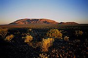
- Kata TjutaKata TjutaKata Tjuta, sometimes written Tjuṯa , and also known as Mount Olga , are a group of large domed rock formations or bornhardts located about southwest of Alice Springs, in the southern part of the Northern Territory, central Australia...
, also known as The Olgas, Northern TerritoryNorthern TerritoryThe Northern Territory is a federal territory of Australia, occupying much of the centre of the mainland continent, as well as the central northern regions...
, AustraliaAustraliaAustralia , officially the Commonwealth of Australia, is a country in the Southern Hemisphere comprising the mainland of the Australian continent, the island of Tasmania, and numerous smaller islands in the Indian and Pacific Oceans. It is the world's sixth-largest country by total area... - Twelve ApostlesThe Twelve Apostles, VictoriaThe Twelve Apostles is a collection of limestone stacks off the shore of the Port Campbell National Park, by the Great Ocean Road in Victoria, Australia...
, Great Ocean RoadGreat Ocean RoadThe Great Ocean Road is a stretch of road along the south-eastern coast of Australia between the Victorian cities of Torquay and Warrnambool. The road was built by returned soldiers between 1919 and 1932, and is the world's largest war memorial; dedicated to casualties of World War I...
, VictoriaVictoria (Australia)Victoria is the second most populous state in Australia. Geographically the smallest mainland state, Victoria is bordered by New South Wales, South Australia, and Tasmania on Boundary Islet to the north, west and south respectively....
, Australia - Remarkable Rocks, South AustraliaSouth AustraliaSouth Australia is a state of Australia in the southern central part of the country. It covers some of the most arid parts of the continent; with a total land area of , it is the fourth largest of Australia's six states and two territories.South Australia shares borders with all of the mainland...
- Wave RockWave RockWave Rock is a natural rock formation located east of the small town of Hyden in Western Australia that is shaped like a tall breaking ocean wave.Wave Rock has cultural significance to Aborigines...
, HydenHyden, Western AustraliaThe town of Hyden is located 339 km east of Perth, Western Australia in the Shire of Kondinin. Hyden is home to Wave Rock and Mulka's Cave, both popular local tourist attractions....
, Western AustraliaWestern AustraliaWestern Australia is a state of Australia, occupying the entire western third of the Australian continent. It is bounded by the Indian Ocean to the north and west, the Great Australian Bight and Indian Ocean to the south, the Northern Territory to the north-east and South Australia to the south-east... - Murphys Haystacks, NullarborNullarbor PlainThe Nullarbor Plain is part of the area of flat, almost treeless, arid or semi-arid country of southern Australia, located on the Great Australian Bight coast with the Great Victoria Desert to its north. It is the world's largest single piece of limestone, and occupies an area of about...
Desert, Western Australia - UluruUluruUluru , also known as Ayers Rock, is a large sandstone rock formation in the southern part of the Northern Territory, central Australia. It lies south west of the nearest large town, Alice Springs; by road. Kata Tjuta and Uluru are the two major features of the Uluṟu-Kata Tjuṯa National Park....
, Northern TerritoryNorthern TerritoryThe Northern Territory is a federal territory of Australia, occupying much of the centre of the mainland continent, as well as the central northern regions...
, Australia - Pinnacles DesertThe Pinnacles DesertThe Pinnacles are limestone formations contained within Nambung National Park, near the town of Cervantes, Western Australia.-Formation:The raw material for the limestone of the Pinnacles came from seashells in an earlier epoch rich in marine life...
, Nambung National ParkNambung National ParkNambung National Park is a national park in the Wheatbelt region of Western Australia , 162 km northwest of Perth. It contains the Pinnacles Desert....
, Western Australia - Devils Marbles, Northern TerritoryNorthern TerritoryThe Northern Territory is a federal territory of Australia, occupying much of the centre of the mainland continent, as well as the central northern regions...
, Australia - Mount AugustusMount Augustus National ParkMount Augustus National Park is located 852 km north of Perth, 490 km by road east of Carnarvon and 390 km northwest of Meekatharra, in the Gascoyne region of Western Australia...
, Western AustraliaWestern AustraliaWestern Australia is a state of Australia, occupying the entire western third of the Australian continent. It is bounded by the Indian Ocean to the north and west, the Great Australian Bight and Indian Ocean to the south, the Northern Territory to the north-east and South Australia to the south-east... - The Three SistersThree Sisters (Australia)The Three Sisters is a rock formation in the Blue Mountains of New South Wales, Australia. They are close to the town of Katoomba and are one of the Blue Mountains' best known sites, towering above the Jamison Valley. Their names are Meehni , Wimlah , and Gunnedoo .-Geology:The Sisters were formed...
, Katoomba - Blue Mountains, New South WalesNew South WalesNew South Wales is a state of :Australia, located in the east of the country. It is bordered by Queensland, Victoria and South Australia to the north, south and west respectively. To the east, the state is bordered by the Tasman Sea, which forms part of the Pacific Ocean. New South Wales...
New Zealand
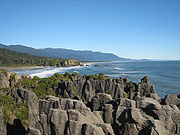
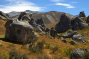
- Castle HillCastle Hill, New ZealandCastle Hill is a location and a high country station in New Zealand's South Island. It is located at an altitude of 700 metres, close to State Highway 73 between Darfield and Arthur's Pass. It is private property....
Basin, CanterburyCanterbury, New ZealandThe New Zealand region of Canterbury is mainly composed of the Canterbury Plains and the surrounding mountains. Its main city, Christchurch, hosts the main office of the Christchurch City Council, the Canterbury Regional Council - called Environment Canterbury - and the University of Canterbury.-... - Koutu Boulders, HokiangaHokiangaHokianga is an area surrounding the Hokianga Harbour, also known as The Hokianga River, a long estuarine drowned valley on the west coast in the north of the North Island of New Zealand....
- Maori Bay giant pillow lava, MuriwaiMuriwaiMuriwai, also called Muriwai Beach, is a coastal community located on the west coast of North Island, New Zealand. It is also home to a large colony of gannets.- Location :...
- Lion Rock, PihaPihaPiha is a northern New Zealand coastal settlement with a population of about 600. It is one of the most popular beaches in the area and a major day-trip destination for Aucklanders throughout the year, although especially so in summer.-Location:...
- Moeraki BouldersMoeraki BouldersThe Moeraki Boulders are unusually large and spherical boulders lying along a stretch of Koekohe Beach on the wave cut Otago coast of New Zealand between Moeraki and Hampden, and are located at . They occur scattered either as isolated or clusters of boulders within a stretch of beach where they...
, OtagoOtagoOtago is a region of New Zealand in the south of the South Island. The region covers an area of approximately making it the country's second largest region. The population of Otago is... - The Nuggets, Nugget PointNugget PointNugget Point is one of the most iconic landforms on the Otago coast. Located at the northern end of the Catlins coast down the road from Kaka Point, this steep headland has a lighthouse at its tip, surrounded by rocky islets...
, Otago - Pancake Rocks, PunakaikiPunakaikiPunakaiki is a small community on the West Coast of the South Island of New Zealand, between Westport and Greymouth. The community lies on the edge of the Paparoa National Park....
- Putangirua Pinnacles, WairarapaWairarapaWairarapa is a geographical region of New Zealand. It occupies the south-eastern corner of the North Island, east of metropolitan Wellington and south-west of the Hawke's Bay region. It is lightly populated, having several rural service towns, with Masterton being the largest...
- Stony BatterStony BatterStony Batter is a historic defence installation at the northeastern end of Waiheke Island, Auckland, New Zealand. It is sited within a 50 acre scenic reserve of the same name, owned by the New Zealand Department of Conservation...
, Waiheke IslandWaiheke IslandWaiheke Island is an island in the Hauraki Gulf of New Zealand, located about from Auckland.The island is the second-largest in the Hauraki Gulf after Great Barrier Island. It is the most populated, with nearly 8,000 permanent residents plus another estimated 3,400 who have second or holiday homes... - Truman Track Beach, Punakaiki
- Wairere BouldersWairere BouldersThe Wairere Boulders are an unusually large assemblage of basalt boulders in the Hokianga, in the far north of New Zealand. The boulder area, surrounded by subtropical rainforest, has been transformed into a park area to enable visitors to view this oddity of nature...
, Hokianga - Gog and Magog, southern Stewart Island/RakiuraStewart Island/RakiuraStewart Island/Rakiura is the third-largest island of New Zealand. It lies south of the South Island, across Foveaux Strait. Its permanent population is slightly over 400 people, most of whom live in the settlement of Oban.- History and naming :...
Other countries
- Fatu Hiva, Marquesas IslandsMarquesas IslandsThe Marquesas Islands enana and Te Fenua `Enata , both meaning "The Land of Men") are a group of volcanic islands in French Polynesia, an overseas collectivity of France in the southern Pacific Ocean. The Marquesas are located at 9° 00S, 139° 30W...
, French PolynesiaFrench PolynesiaFrench Polynesia is an overseas country of the French Republic . It is made up of several groups of Polynesian islands, the most famous island being Tahiti in the Society Islands group, which is also the most populous island and the seat of the capital of the territory... - Talava Arches, NiueNiueNiue , is an island country in the South Pacific Ocean. It is commonly known as the "Rock of Polynesia", and inhabitants of the island call it "the Rock" for short. Niue is northeast of New Zealand in a triangle between Tonga to the southwest, the Samoas to the northwest, and the Cook Islands to...
, South Pacific