

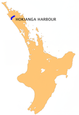
Hokianga
Encyclopedia

North Island
The North Island is one of the two main islands of New Zealand, separated from the much less populous South Island by Cook Strait. The island is in area, making it the world's 14th-largest island...
of New Zealand
New Zealand
New Zealand is an island country in the south-western Pacific Ocean comprising two main landmasses and numerous smaller islands. The country is situated some east of Australia across the Tasman Sea, and roughly south of the Pacific island nations of New Caledonia, Fiji, and Tonga...
.
The original name still used by local Māori is Te Kohanga o Te Tai Tokerau ("the nest of the northern people") or Te Puna o Te Ao Marama ("the wellspring of moonlight"). The full name of the Harbour is Te Hokianga-nui-a-Kupe - "the place of Kupe's great return".
Geography
Whangarei
Whangarei, pronounced , is the northernmost city in New Zealand and the regional capital of Northland Region. Although commonly classified as a city, it is officially part of the Whangarei District, administered by the Whangarei District Council a local body created in 1989 to administer both the...
and 25 kilometres west of Kaikohe
Kaikohe
Kaikohe is the central service area for the Far North District of New Zealand, about 260 km from Auckland, situated on State Highway 12 at...
. The estuary extends inland for 30 kilometres from the Tasman Sea
Tasman Sea
The Tasman Sea is the large body of water between Australia and New Zealand, approximately across. It extends 2,800 km from north to south. It is a south-western segment of the South Pacific Ocean. The sea was named after the Dutch explorer Abel Janszoon Tasman, the first recorded European...
. It is navigable for small craft for much of its length, although there is a bar across the mouth.
Twelve thousand years ago Hokianga was a river valley flanked by steep bush-clad hills. As the last ice age regressed, the dramatic rise in sea level slowly flooded the valley turning it into a tidal, saltwater, harbour with abundant sheltered deep water anchorages. This was the harbour that Kupe left from, and in 1822 saw the first European timber entrepreneurs.
The area around the harbour is divided in three by the estuary. To the south are the settlements of Waimamaku, Omapere, Opononi
Opononi
Opononi is a settlement on the south shore of the Hokianga harbour in Northland Region, New Zealand. State Highway 12 runs through Opononi. Omapere lies to the south and Whirinaki lies to the north east....
, Pakanae, Koutu, Whirinaki
Whirinaki, Northland
Whirinaki is a locality in the south Hokianga, in Northland, New Zealand. The name means "to lean against a support". Highway 12 runs through it. Opononi lies to the south west, and Rawene lies to the north east....
, Rawene
Rawene
Rawene is a town on the south side of the Hokianga harbour, in Northland, New Zealand. State Highway 12 passes to the south. The town lies at the apex of a peninsula...
, Waima
Waima, Northland
Waima is a community in the south Hokianga area of Northland, New Zealand. State Highway 12 runs through the area. The Waima River flows through the Waima Valley into the Hokianga Harbour. Rawene is to the north west, and Kaikohe is to the north east....
, and Taheke; to the north are Broadwood
Broadwood, New Zealand
Broadwood is a town about 25 km to the north of the north side of the Hokianga harbour, in Northland, New Zealand. Herekino is 21 km to the west, and Mangamuka Bridge is the same distance to the east....
, Pawarenga, Panguru
Panguru
Panguru is a community in the northern Hokianga harbour, in Northland, New Zealand. The Whakarapa Stream flows from the Panguru Range in the Warawara Forest to the west, through Panguru and into the Hokianga...
, Mitimiti, and Rangi Point; and at the top of the harbour upstream from the narrows are Horeke
Horeke
Horeke is a settlement in the upper reaches of the Hokianga harbour in Northland, New Zealand. Kohukohu is just across the harbour. The Wairere Boulders is located in the Hokianga Harbour near the town .-History:...
, Kohukohu
Kohukohu, New Zealand
Kohukohu is an historic village on the Hokianga Harbour in the far north of the North Island. It was one of the first European settlements in New Zealand....
and Mangamuka
Mangamuka
Mangamuka is a district in Northland, New Zealand, at the junction of the Mangamuka and Opurehu Rivers. State Highway 1 runs through the area, and the settlement of Mangamuka Bridge lies at the point where the highway crosses the Mangamuku River. The river runs into the upper Hokianga Harbour...
.
History
According to Te Tai Tokerau tradition, KupeKupe
In the Māori mythology of some tribes, Kupe was involved in the Polynesian discovery of New Zealand.-Contention:There is contention concerning the status of Kupe. The contention turns on the authenticity of later versions of the legends, the so-called 'orthodox' versions closely associated with S....
, the legendary Polynesian navigator and explorer, settled in Hokianga in approximately 925 AD, after his journey of discovery from Hawaiiki aboard the waka (canoe) named Matahorua. When he left Hokianga he declared that this would be the place of his return and left several things behind including the bailer of his canoe. Later, Kupe's grandson Nukutawhiti returned from Hawaiiki to settle in Hokianga.
In the 14th century, the great chief Puhi landed just south of the Bay of Islands
Bay of Islands
The Bay of Islands is an area in the Northland Region of the North Island of New Zealand. Located 60 km north-west of Whangarei, it is close to the northern tip of the country....
. The tribe of Puhi, Ngapuhi
Ngapuhi
Ngāpuhi is a Māori iwi located in the Northland region of New Zealand, and centred in the Hokianga, the Bay of Islands and Whāngārei.Ngāpuhi has the largest affiliation of any New Zealand iwi, with 122,214 people registered , and formed from 150 hapu, with 55 marae.-Foundations:The founding...
, slowly extended westwards to reach the west coast and colonise both sides of Hokianga. Hokianga is considered to be one of the oldest settlements for the Māori, and is still a heartland for the people. Rahiri, the 17th century founder of the Ngapuhi iwi, was born at Whiria pa
Pa (Maori)
The word pā can refer to any Māori village or settlement, but in traditional use it referred to hillforts fortified with palisades and defensive terraces and also to fortified villages. They first came into being about 1450. They are located mainly in the North Island north of lake Taupo...
to the south of the harbour, where a monument stands to his memory.
In this process of expansion the Ngapuhi created and maintained over centuries a complex network of walking tracks, many of which evolved into today's roads. Wesleyan and later Anglican missionaries
Mission (Christian)
Christian missionary activities often involve sending individuals and groups , to foreign countries and to places in their own homeland. This has frequently involved not only evangelization , but also humanitarian work, especially among the poor and disadvantaged...
were guided along these ancient routes to make their own discovery of Hokianga and its accessible timber resources. Their reports soon reached merchant captains in the Bay of Islands.
Captain Herd of the Providence was the first to respond, and with disgraced missionary Thomas Kendall
Thomas Kendall
Thomas Kendall was a New Zealand lapsed missionary, recorder of the Māori language, schoolmaster, arms dealer, and Pākehā Māori.-Early life: Lincolnshire and London, 1778-1813:...
as guide and translator, crossed the bar and entered the harbour in 1822 (the first European ship to do so) and sailed away with the first Hokianga timber shipment. His success inspired a strong following—the deforestation of Hokianga had begun and would be completed by the turn of the century.
The only disincentive to Hokianga's exploitation was the harbour bar. Of the hundreds of ships that successfully negotiated it, the records show that 16 were lost. Most came to grief when leaving fully laden and became caught in the wind shadow cast by South Head where the deep water lay. A temporary lull or change in wind direction could cause a sailing-ship to lose steerage way and be swept onto the rocky shore.
In 1828 the missionary schooner
Schooner
A schooner is a type of sailing vessel characterized by the use of fore-and-aft sails on two or more masts with the forward mast being no taller than the rear masts....
Herald, built by Henry Williams
Henry Williams (missionary)
Henry Williams was one of the first missionaries who went to New Zealand in the first half of the 19th century....
and sailed by Gilbert Mair
Gilbert Mair (trader)
Gilbert Mair was a sailor and a merchant trader who visited New Zealand for the first time when he was twenty, and lived there from 1824 till his death. He married Elizabeth Gilbert Puckey. They had twelve children. Among them were "famous New Zealanders" like Captain Gilbert Mair and Major...
foundered, while trying to enter Hokianga Harbour.
The last recorded shipwreck was the schooner Isabella de Fraine which was lost with all eight crew in July 1928 after capsizing on the bar at the entrance to the harbour.
In 1837 a French aristocrat with delusions of grandeur, Baron Charles de Thierry, sailed with 60 settlers into this hive of export activity to claim an immense tract of land that he believed he had purchased for 36 axes, 15 years earlier. He was eventually granted about 1,000 acres (4 km²) at Rangiahua
Rangiahua
Rangiahua is a small locality near the Hokianga Harbour in the Northland Region of New Zealand. State Highway 1 passes through it. Umawera is to the west, and Okaihau to the east.Rangiahua nearly became New Zealand's most northern railway terminus...
where he set up his colony declaring himself 'Sovereign Chief of New Zealand', a title that failed to endear him to Ngapuhi. His project collapsed and he left behind him a few ancient fruit trees and a lot of gouty DNA. His visit at least inspired the Colonial Service to get on with a treaty in the face of this implied Gallic threat.
The year after de Thierry arrived another French connection, Bishop Jean Baptiste Pompallier
Jean Baptiste Pompallier
Jean Baptiste François Pompallier was the first vicar apostolic to visit New Zealand. He was born in Lyon, France. He became the first Roman Catholic Bishop of Auckland.-Appointment and voyage:...
, sailed in to establish a Catholic
Catholic
The word catholic comes from the Greek phrase , meaning "on the whole," "according to the whole" or "in general", and is a combination of the Greek words meaning "about" and meaning "whole"...
mission. He found the southern shores firmly in the hands of Methodist and Anglican missionaries, but the northern side was ripe for conversion. His remains, recently claimed by Ngapuhi, lie buried where the mission began. Today the harbour, like the Reformation
Protestant Reformation
The Protestant Reformation was a 16th-century split within Western Christianity initiated by Martin Luther, John Calvin and other early Protestants. The efforts of the self-described "reformers", who objected to the doctrines, rituals and ecclesiastical structure of the Roman Catholic Church, led...
, stands between Protestant and Catholic.
Hauora
The Hauora, is a Maori philosophy of health and well-being unique to New Zealand.The Hauora has been compared to the four walls of a whare, each wall representing a different dimension. All four dimensions are necessary for strength and stability....
Hokianga) is located, on top of the hill at the Hokianga Hospital.
Within six days of the Waitangi signing
Treaty of Waitangi
The Treaty of Waitangi is a treaty first signed on 6 February 1840 by representatives of the British Crown and various Māori chiefs from the North Island of New Zealand....
, Governor Hobson
William Hobson
Captain William Hobson RN was the first Governor of New Zealand and co-author of the Treaty of Waitangi.-Early life:...
, keen to secure full Ngapuhi support, trekked across to the Mangungu Mission House near Horeke where 3000 were waiting. This was the second signing of the Treaty of Waitangi on 12 February 1840. With the appropriate signatures (and a few inappropriate entries) he could immediately claim support from the biggest tribe in the country.
While the fate of the nation was being signed into history, the axemen of Hokianga scarcely missed a beat. At any one time, as many as 20 ships could be loading Hokianga timber. Whole hillsides, suddenly bared of vegetation, began to slip into the harbour choking its tributaries with mud.
The relationship between Māori and Pākehā
Pakeha
Pākehā is a Māori language word for New Zealanders who are "of European descent". They are mostly descended from British and to a lesser extent Irish settlers of the nineteenth and twentieth centuries, although some Pākehā have Dutch, Scandinavian, German, Yugoslav or other ancestry...
(European) settlers was frequently tense, never more so than during the Dog Tax War
Dog Tax War
The Dog Tax war is described by some authors as the last gasp of the 19th century wars between the Māori and the Pākehā, the British settlers of New Zealand. This is not altogether accurate in two respects. It was a very minor affair, certainly not a war...
of the 1890s, which was largely centred around Hokianga.
By 1900, the bulk of the forest had sailed over the bar and the little topsoil that remained was turned to dairy farming for butter production.
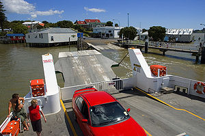
Most of the cream delivered to the Mokukaraka Dairy Factory was carried there by a fleet of about fifty locally built launches that criss-crossed the harbour daily, creating in the process a service for both passengers and freight. For half a century, the communities on both sides of the harbour were linked internally by sea transport, before improved roads in the 1950s finally displaced this energetic flotilla and the harbour once again divided the community.

1918 influenza pandemic
The influenza pandemicSpanish flu
The 1918 flu pandemic was an influenza pandemic, and the first of the two pandemics involving H1N1 influenza virus . It was an unusually severe and deadly pandemic that spread across the world. Historical and epidemiological data are inadequate to identify the geographic origin...
reached Hokianga in September 1918, and remote Waiotemarama was one of the first settlements to succumb. A soup kitchen was organised in each community. Mounted and armed guards were placed at all crossroads to turn back would-be visitors and thus restrict the spread of the disease between settlements. Travellers wishing to enter Hokianga were simply stopped at the boundary. The rule was simple: anyone could leave, but no one could enter.
The local epidemic lasted six weeks and a significant number died. Each community attended to its own and mass burials were commonplace. Few Maori deaths were recorded - the true impact of the epidemic on Maori is unknown.
Industry
The first major industry of the region was based around the kauri trees, both logging and the gum, the strong thick resin which came from the trees. After the forests started to thin, dairyDairy
A dairy is a business enterprise established for the harvesting of animal milk—mostly from cows or goats, but also from buffalo, sheep, horses or camels —for human consumption. A dairy is typically located on a dedicated dairy farm or section of a multi-purpose farm that is concerned...
ing and cheese
Cheese
Cheese is a generic term for a diverse group of milk-based food products. Cheese is produced throughout the world in wide-ranging flavors, textures, and forms....
production took over as the mainstay of the economy, but they too fell away after the closure of the Motukaraka Dairy Cooperative in 1953. For a while during the 1970s and 1980s, there was little economic base for the area, and it became a haven for alternative lifestyle
Alternative lifestyle
An alternative lifestyle is a lifestyle generally perceived to be outside the cultural norm. Usually, but not always, it implies an affinity or identification within some matching subculture...
rs.
In recent years, however, tourism has become of significance to the region. Attractions such as the great kauri trees of the Waipoua Forest
Waipoua Forest
Waipoua Forest preserves some of the best examples of kauri forest remaining in New Zealand. It is notable for having two of the largest living kauri trees, Tane Mahuta and Te Matua Ngahere.The forest was declared a sanctuary in 1952....
(including the country's tallest tree, Tane Mahuta
Tane Mahuta
Tāne Mahuta is a giant kauri tree in the Waipoua Forest of Northland Region, New Zealand. Its age is unknown but is estimated to be between 1,250 and 2,500 years old. It is the largest kauri known to stand today...
), the historic waterfront villages of Kohukohu
Kohukohu, New Zealand
Kohukohu is an historic village on the Hokianga Harbour in the far north of the North Island. It was one of the first European settlements in New Zealand....
and Rawene, cafes, the Wairere Boulders
Wairere Boulders
The Wairere Boulders are an unusually large assemblage of basalt boulders in the Hokianga, in the far north of New Zealand. The boulder area, surrounded by subtropical rainforest, has been transformed into a park area to enable visitors to view this oddity of nature...
, beaches, historic buildings, nature walks, horse trekking, boat trips, and fishing are bringing more visitors every year.
Hokianga celebrities
Two iconic and very different figures in New Zealand history have been closely associated with the Hokianga.Dame Whina Cooper
Dame Whina CooperWhina Cooper
Dame Whina Cooper ONZ DBE , was born Hohewhina Te Wake, daughter of Heremia Te Wake of the Te Rarawa iwi, at Te Karaka, Hokianga,...
was born at Te Karaka, Hokianga on 9 December 1895, the daughter of a leader of the Te Rarawa
Te Rarawa
Te Rarawa is a Māori iwi of Northland, New Zealand.-Prominent Te Rarawa:*Hector Busby, navigator and waka builder.*Whina Cooper, woman of mana, teacher, storekeeper and community leader....
iwi
Iwi
In New Zealand society, iwi form the largest everyday social units in Māori culture. The word iwi means "'peoples' or 'nations'. In "the work of European writers which treat iwi and hapū as parts of a hierarchical structure", it has been used to mean "tribe" , or confederation of tribes,...
.
From an early age she showed an interest in local community affairs and politics, and her flair and abilities led to her becoming the undisputed Māori leader of the northern Hokianga by her mid-30s.
In 1949 she moved to Auckland
Auckland
The Auckland metropolitan area , in the North Island of New Zealand, is the largest and most populous urban area in the country with residents, percent of the country's population. Auckland also has the largest Polynesian population of any city in the world...
, and by 1951 she was elected first president of the new Māori Women’s Welfare League. The league’s success was largely due to Whina’s efforts, and she became well-known throughout the country. In 1957 she stepped down as president and the annual conference rewarded her with the title Te Whaea o te Motu ("Mother of the Nation").
Whina Cooper continued to work for the community throughout the 1960s, but it was her 1975 leadership of a hikoi
Hikoi
Hikoi is a term of the Maori language of New Zealand generally meaning a protest march or parade, usually implying a long journey taking days or weeks....
- a symbolic march - to protest against the loss of Māori land for which she is best remembered. The march, from the northern tip of the North Island to Parliament in Wellington
Wellington
Wellington is the capital city and third most populous urban area of New Zealand, although it is likely to have surpassed Christchurch due to the exodus following the Canterbury Earthquake. It is at the southwestern tip of the North Island, between Cook Strait and the Rimutaka Range...
at the other end of the island made her nationally recognised, with her determined figure, no longer strong in body but strong in mana
Mana
Mana is an indigenous Pacific islander concept of an impersonal force or quality that resides in people, animals, and inanimate objects. The word is a cognate in many Oceanic languages, including Melanesian, Polynesian, and Micronesian....
and will, walking at the head of the march from Te Hapua to Wellington.
She was made a DBE
Order of the British Empire
The Most Excellent Order of the British Empire is an order of chivalry established on 4 June 1917 by George V of the United Kingdom. The Order comprises five classes in civil and military divisions...
in 1981 and a member of the Order of New Zealand
Order of New Zealand
The Order of New Zealand is the highest honour in New Zealand's honours system, created "to recognise outstanding service to the Crown and people of New Zealand in a civil or military capacity"...
in 1991. She had returned to Panguru in the Hokianga in 1983. She died there on 26 March 1994 at the age of 98.
Opo the dolphin
Opononi became famous throughout New Zealand during 1955 and 1956 due to the exploits of a bottlenose dolphinBottlenose Dolphin
Bottlenose dolphins, the genus Tursiops, are the most common and well-known members of the family Delphinidae, the family of oceanic dolphins. Recent molecular studies show the genus contains two species, the common bottlenose dolphin and the Indo-Pacific bottlenose dolphin , instead of one...
(nicknamed "Opo
Opo the Dolphin
Opo was a bottlenose dolphin who became famous throughout New Zealand during the summer of 1955-56 for playing with the children of the small town of Opononi on the Hokianga harbour....
"). Opo was a wild dolphin who started following fishing boats around Opononi in early 1955 after her mother had been killed, and would swim daily in the bay close to town. She was originally named "Opononi Jack", based on Pelorus Jack
Pelorus Jack
Pelorus Jack was a Risso's dolphin that was famous for meeting and escorting ships through a stretch of water in Cook Strait, New Zealand, between 1888 and 1912...
, since she was presumed to be male. Unlike the majority of dolphins, she had no qualms about human company, and would perform stunts for locals, play with objects like beach balls and beer bottles, and allow children to swim alongside her and make contact.
The dolphin became a local celebrity but news of her soon spread, and visitors from throughout the country would come to watch her. On 8 March 1956 official protection for Opo, requested by locals, was made law, but on 9 March she was found dead in a rock crevice at Koutu Point. It is suspected that she was killed accidentally by fishermen fishing with gelignite
Gelignite
Gelignite, also known as blasting gelatin or simply jelly, is an explosive material consisting of collodion-cotton dissolved in either nitroglycerine or nitroglycol and mixed with wood pulp and saltpetre .It was invented in 1875 by Alfred Nobel, who had earlier invented dynamite...
. Her death was reported nationwide, and she was buried with full Māori honours in a special plot next to the town hall.
Education
There are composite (years 1-15) schools at OpononiOpononi
Opononi is a settlement on the south shore of the Hokianga harbour in Northland Region, New Zealand. State Highway 12 runs through Opononi. Omapere lies to the south and Whirinaki lies to the north east....
, Panguru
Panguru
Panguru is a community in the northern Hokianga harbour, in Northland, New Zealand. The Whakarapa Stream flows from the Panguru Range in the Warawara Forest to the west, through Panguru and into the Hokianga...
and Broadwood
Broadwood, New Zealand
Broadwood is a town about 25 km to the north of the north side of the Hokianga harbour, in Northland, New Zealand. Herekino is 21 km to the west, and Mangamuka Bridge is the same distance to the east....
.
There are also primary schools at Horeke
Horeke
Horeke is a settlement in the upper reaches of the Hokianga harbour in Northland, New Zealand. Kohukohu is just across the harbour. The Wairere Boulders is located in the Hokianga Harbour near the town .-History:...
, Kohukohu
Kohukohu, New Zealand
Kohukohu is an historic village on the Hokianga Harbour in the far north of the North Island. It was one of the first European settlements in New Zealand....
, Matihetihe
Matihetihe
Matihetihe is a community in the Hokianga area of Northland, New Zealand. The Warawara Forest lies to the north. The Matihetihe Stream runs into the Tasman Sea to the west.-Education:...
, Omanaia
Omanaia
Omanaia is a settlement in the Hokianga area of Northland, New Zealand.In the 1830s, the Omanaia Maori chief Papahurihia led a nationalist movement to oppose the spread of Christianity through the Hokianga.-Education:...
, Pawarenga, Rawene
Rawene
Rawene is a town on the south side of the Hokianga harbour, in Northland, New Zealand. State Highway 12 passes to the south. The town lies at the apex of a peninsula...
, Waima
Waima, Northland
Waima is a community in the south Hokianga area of Northland, New Zealand. State Highway 12 runs through the area. The Waima River flows through the Waima Valley into the Hokianga Harbour. Rawene is to the north west, and Kaikohe is to the north east....
and Whirinaki
Whirinaki, Northland
Whirinaki is a locality in the south Hokianga, in Northland, New Zealand. The name means "to lean against a support". Highway 12 runs through it. Opononi lies to the south west, and Rawene lies to the north east....
.
External links
- Hauora Hokianga Hokianga's community governed health services
- Hokianga Map An interactive google map by Hauora Hokianga
- Hokianga from the NZ Community Development Trust
- Hokianga Tourism Association
- Hokianga History and Tourism
- Hokianga History
- Dictionary of New Zealand Biography essay on Dame Whina Cooper
- Rawene Website
- Horeke Community Website
- Kohukohu Community Website