
County Donegal
Encyclopedia
County Donegal is a county
in Ireland
. It is part of the Border Region
and is also located in the province
of Ulster
. It is named after the town of Donegal
. Donegal County Council
is the local authority
for the county. The population of the county is 160,927 according to the 2011 census.
and the fourth largest county in all of Ireland
. Uniquely, County Donegal shares a border with only one other county in the Republic of Ireland
– County Leitrim
. The majority of its land border is shared with three counties of Northern Ireland
: County Londonderry
, County Tyrone
and County Fermanagh
. This geographic isolation from the rest of the Republic has led to Donegal people maintaining a distinct cultural identity and has been used to market the county with the slogan
Up here it's different. While Lifford
is the County Town
, Letterkenny
is by far the largest town in the county. Letterkenny and the nearby city of Derry
form the main economic axis of the north-west of Ireland.
in the county:
Townlands
districts in the west: The Rosses
, centred on the town of Dungloe
, and Gweedore
. Another Gaeltacht district is located in the north-west: Cloughaneely
, centred on the town of Falcarragh
. The most northerly part of the island of Ireland is the location for three peninsula
e of outstanding natural beauty: Inishowen
, Fanad
and Rosguill
. The main population centre of Inishowen, one of Ireland's largest peninsulae, is Buncrana. In the east of the county lies the Finn Valley
(centred on Ballybofey
). The Laggan district (not to be confused with the more famous Lagan Valley
in the south of County Antrim
) is centred on the town of Raphoe
.
had Donegal's population standing at 147,264.
 Physically, the county is by far the most rugged and mountainous in Ulster
. The county consists chiefly of low mountains, with a deeply indented coastline forming natural lough
s, of which both Lough Swilly
and Lough Foyle
are the most notable. The famous mountains (often known as 'the Hills of Donegal') consist of two major ranges, the Derryveagh Mountains
in the north and the Bluestack Mountains
in the south, with Mount Errigal
at 749 metres (2,457 ft) the highest peak. The Slieve League
cliffs are the sixth-highest sea cliffs in Europe
, while Donegal's Malin Head
is the most northerly point on the island of Ireland.
The climate is temperate and dominated by the Gulf Stream
, with warm, damp summers and mild wet winters. Two permanently inhabited islands, Arranmore
and Tory Island
, lie off the coast, along with a large number of islands with only transient inhabitants. Ireland's second longest river, the Erne
, enters Donegal Bay
near the town of Ballyshannon
. The River Erne
, along with other Donegal waterways, has been dammed to produce hydroelectric
power. The River Foyle
separates part of County Donegal from parts of both counties Londonderry
and Tyrone
.
of County Donegal was published in 2003. The survey was compiled using the algal records held in the herbaria of the following institutions: the Ulster Museum
in Stranmillis
, Belfast
; Trinity College
, Dublin; University College, Galway; and the Natural History Museum in South Kensington
, London
.
 At various times in its history, it has been known as County Tirconaill, County Tirconnell or County Tyrconnell . The former was used as its official name during 1922–1927. This is in reference to both the old túath
of Tír Chonaill and the earldom that succeeded it.
County Donegal is famous for being the home of the once mighty Clann Dálaigh, whose most famous branch were the Clann Ó Domhnaill, better known in English
as the O'Donnell Clan
. Until around 1600, the O'Donnells were one of Ireland's richest and most powerful Gaelic
(native Irish) ruling-families. Within the Province of Ulster
only the Clann Uí Néill (known in English as the O'Neill Clan
) of modern County Tyrone
were more powerful. The O'Donnells were Ulster's second most powerful clan or ruling-family from the early 13th-century through to the start of the 17th-century. For several centuries the O'Donnells ruled Tír Chonaill, a Gaelic kingdom in West Ulster that covered almost all of modern County Donegal. The head of the O'Donnell family had the titles An Ó Domhnaill (meaning The O'Donnell in English) and Rí Thír Chonaill (meaning King of Tír Chonaill in English). Based at Donegal Castle
in Dún na nGall (modern Donegal Town
), the O'Donnell Kings of Tír Chonaill were traditionally inaugurated at Doon Rock near Kilmacrenan
. O'Donnell royal or chiefly power was finally ended in what was then the newly created County Donegal in September, 1607, following the Flight of the Earls
from near Rathmullan
. The modern County Arms of Donegal (dating from the early 1970s) was influenced by the design of the old O'Donnell royal arms. The County Arms is the official coat of arms
of both County Donegal and Donegal County Council.
The modern County Donegal was shire
d by order of the English
Crown in 1585. The English authorities at Dublin Castle
formed the new county by amalgamating the old Kingdom of Tír Chonaill with the old Lordship of Inishowen
. However, the English authorities were unable to establish control over Tír Chonaill and Inishowen until after the Battle of Kinsale
in 1602. Full control over the new County Donegal was only achieved after the Flight of the Earls
in September, 1607. The county was one of those 'planted' during the Plantation of Ulster
from around 1610 onwards.
County Donegal was one of the worst affected parts of Ulster
during the Great Famine of the late 1840s in Ireland
. Vast swathes of the county were devastated by this catastrophe, many areas becoming permanently depopulated. Vast numbers of County Donegal's people emigrated at this time, chiefly through the Port of Derry
. Huge numbers of the county's people who emigrated were to settle in Glasgow
in southern Scotland
.
The Partition of Ireland
in the early 1920s was to have a massive direct impact on County Donegal. Partition
cut the county off, economically and administratively, from Derry
, which had acted for centuries as the county's main port, transport hub and financial centre. Derry, together with West Tyrone, was henceforward in a new, different jurisdiction
officially called Northern Ireland
. Partition also meant that County Donegal was now almost entirely cut off from the rest of the jurisdiction it now found itself in, the new dominion
called the Irish Free State
. This dominion became fully independent in April 1949 when it left the Commonwealth
and became the Republic of Ireland
. Only a few miles of the county is physically connected by land to the rest of the Republic. The existence of this border, cutting Donegal off from her natural hinterlands in Derry City and West Tyrone, has greatly exacerbated the economic difficulties of the county since partition. The county's economy is particularly susceptible, just like that of Derry City, to the currency fluctuations of the Euro
against Sterling
.
Added to all this, in the late twentieth-century, County Donegal was, by the standards of the rest of the Republic of Ireland, to be adversely affected by The Troubles
in Northern Ireland. The county was to suffer several bombings and at least two assassinations. In June 1987, Constable Samuel McClean, a Donegal man who was a serving member of the R.U.C.
, was shot dead by the I.R.A.
at his family home near Drumkeen. In May 1991, the prominent Sinn Féin
politician Councillor
Eddie Fullerton
was assassinated by the U.D.A.
at his home in Buncrana. This added further to the economic and social difficulties of the county. However, the Good Friday Agreement
(G.F.A.) of April 1998 has been of great benefit to the county.
It has been labelled the 'forgotten county' by its own politicians, owing to the increasing regularity with which it is ignored by the Irish Government
, even in times of crisis.
, the county holding the second-largest Gaeltacht
area in the country with a population of 24,504. 16% of the county's population lives in the Gaeltacht
. Gweedore is the largest Irish-speaking parish with over 4,000 inhabitants. All schools in the region use Irish as the language of instruction. One of the N.U.I.G.
's constituent colleges, Acadamh na hOllscolaíochta Gaeilge
, is based in Gweedore
. The version of the Irish language
spoken in County Donegal is Ulster Irish
.
(which has officially been in existence since 1899) has responsibility for local administration, and is headquartered at the County House in Lifford
. The County Council
runs alongside Town Councils in Letterkenny
, Bundoran
, Ballyshannon
and Buncrana. Both the County Council and Town Councils have elections every five years (alongside local elections nationally, and elections to the European Parliament
), the last of which took place on the 5 June 2009. Twenty nine councillors are elected using the system of Proportional representation
-Singe Transferable Vote (STV), across five electoral areas (Inishowen
– 7 seats, Letterkenny
– 7 seats, Donegal
– 5 seats, Stranorlar
– 5 seats, and Glenties
– 5 seats.
For General election
s, the county is divided into two constituencies, Donegal South West
and Donegal North East
, with both having three representatives in Dáil Éireann
. For elections to the European Parliament
, the county is part of the North–West constituency (formerly Connacht–Ulster).
and the Londonderry and Lough Swilly Railway Company
(known as the L. & L.S.R. or the Lough Swilly Company for short). The Great Northern Railway (Ireland)
L.t.d. (the G.N.R.) also ran a line from Strabane
through The Laggan, a district in the east of the county, along the River Foyle
into Derry. Even though the railways in Donegal are fondly remembered, the network was completely closed by 1960. Today, the closest railway station to the county is Waterside Station
in the City of Derry, which is operated by Northern Ireland Railways (N.I.R.).
County Donegal is served by both Donegal Airport
, located at Carrickfinn in The Rosses
in the west of the county, and by City of Derry Airport
, located at Eglinton
to the east. The nearest main international airport to the county is Belfast International Airport
(popularly known as Aldergrove Airport), which is located to the east at Aldergrove, near Antrim Town
, in County Antrim
, around fifty-seven miles from Derry City and around seventy-five miles from Letterkenny.
 The variant of the Irish language
spoken in Donegal shares many traits with Scottish Gaelic. The Irish spoken in the Donegal Gaeltacht
(Irish-speaking area) is of the Ulster dialect
, while Inishowen
(parts of which only became English
-speaking in the early 20th century) used the East Ulster dialect. Ulster Scots is often spoken in both the Finn Valley
and The Laggan district of East Donegal. Donegal Irish has a strong influence on learnt Irish
across Ulster.
Like other areas on the western seaboard of Ireland, Donegal has a distinctive fiddle tradition
which is of world renown. Donegal is also well known for its songs which have, like the instrumental music, a distinctive sound. Donegal musical artists such as the bands Clannad
and Altan and solo artist Enya
, all from Gaoth Dobhair, have had international success with traditional or traditional flavoured music. Donegal music has also influenced people not originally from the county including folk and pop singer Paul Brady
. Popular music
is also common, the county's most acclaimed rock artist being the Ballyshannon
-born Rory Gallagher
.
 Donegal has a long literary tradition in both Irish
and English
. The famous Irish navvy
-turned-novelist Patrick MacGill
, author of many books about the experiences of Irish migrant itinerant
labourers in Britain
at around the turn of the 20th century, such as The Rat Pit and the autobiographical Children of the Dead End, is from the Glenties
area. There is a literary summer school in Glenties
named in his honour. The novelist and socialist
politician Peadar O'Donnell
hails from The Rosses
in west Donegal. The Poet William Allingham
was also from Ballyshannon. Modern exponents include the Inishowen
playwright and poet Frank McGuinness
and the playwright Brian Friel
. Many of Friel's plays are set in the fictional Donegal town of Ballybeg
.
Authors in Donegal have been creating works, like the Annals of the Four Masters
, in Gaelic
and Latin
since the Early Middle Ages
. The Irish philosopher John Toland
was born in Inishowen
in 1670. He was thought of as the original freethinker
by George Berkeley
. Toland was also instrumental in the spread of freemasonry throughout Continental Europe
. In modern Irish
Donegal has produced famous, and sometimes controversial, authors such as the brothers Séamus Ó Grianna
and Seosamh Mac Grianna
from The Rosses
and the contemporary (and controversial) Irish-language poet Cathal Ó Searcaigh
from Gortahork
in Cloughaneely, and where he is known to locals as Gúrú na gCnoc ('the Guru of the Hills').
Although approximately 85% of its population is Catholic, County Donegal also has a sizeable Protestant
minority. Most Donegal Protestants would trace their ancestors to settlers who arrived during the Plantation of Ulster
in the early seventeenth-century. The Church of Ireland
is the largest Protestant denomination but is closely rivalled by a large number of Presbyterians
. The areas of Donegal with the highest percentage of Protestants are The Laggan area of East Donegal around Raphoe
, the Finn Valley and areas around Ramelton, Milford and Dunfanaghy – where their proportion reaches up to 30–45 percent. There is also a large Protestant population between Donegal Town
and Ballyshannon
in the south of the county. In absolute terms, Letterkenny
has the largest number of Protestants (over 1000) and is the most Presbyterian town (among those settlements with more than 3000 people) in the Republic of Ireland
. Some County Donegal Protestants (mainly those concentrated in The Laggan and the Donegal Town/Ballintra areas) are members of the Orange Order
, a controversial religious and social society.
The Earagail Arts Festival
is held within the county each July
. It is considered to be one of the best arts festivals in Ireland, North
or South
. It is certainly one of the main arts festivals within Ulster
.
Donegal has also contributed to culture elsewhere. One Donegal native, Francis Alison, was one of the founders of the College of Philadelphia, which would later become the University of Pennsylvania
. The Rev. Francis Makemie
(originally from Ramelton
) founded the Presbyterian Church in America. The Rev. David Steele
, from Upper Creevaugh, was a prominent Reformed Presbyterian, or Covenanter
, minister who emigrated to the United States in 1824. He maintained a strict testimony for the Covenanted Reformation until his death, in Philadelphia, in 1887.
 With its sandy beaches, unspoilt boglands and friendly communities, Co. Donegal is a favoured destination for many travellers, Irish
(especially Northern Irish
) and foreign alike. One of the county treasures is Glenveagh
National Park (formerly part of the Glenveagh Estate), as yet (November 2010) the only official national park anywhere in the Province of Ulster
. The park is a 140 km² (about 35,000 acre) nature reserve with spectacular scenery of mountains, raised boglands, lakes and woodlands. At its heart is Glenveagh Castle
, a beautiful late Victorian
'folly' that was originally built as a summer residence.
The Donegal Gaeltacht
(Irish
-speaking district) also attracts young people to County Donegal each year during the school summer holidays. The three week long summer Gaeltacht courses give young Irish people from other parts of the country a chance to learn the Irish language and traditional Irish cultural traditions that are still prevalent in parts of Donegal. The Donegal Gaeltacht has traditionally been a very popular destination each summer for young people from Northern Ireland
. Scuba Diving is also very popular with a club being located in Donegal Town.
(L.Y.I.T.; popularly known locally as 'the Regional'), established in the 1970s in Letterkenny
. In addition, many young people from the county attend third-level institutions elsewhere in Ireland, especially in Derry
and also at the University of Ulster at Coleraine
(U.U.C.), the University of Ulster at Jordanstown
(U.U.J.), The Queen's University of Belfast ('Queen's'), and NUI Galway
. Many Donegal students also attend the Limavady
Campus of the North West Regional College
(popularly known as Limavady Tech) and the Omagh Campus
of South West College
(popularly known as Omagh Tech or Omagh College).
sport of Gaelic football
is very popular in Donegal. Donegal's inter-county football team have won the All-Ireland Senior Football Championship
title once (in 1992). In 2007 Donegal won only their second national title by winning the National Football League
. On 24 April 2011, Donegal added their third national title when they defeated Laois to capture the National Football League Division Two. There are 16 clubs in the Donegal Senior Football Championship, with many others playing at a lower level.
Hurling
, handball and rounders are also played but are less widespread, as in other parts of northwestern Ireland. The Donegal county senior hurling team has never managed a title.
teams in the county. These include Ulster Qualifying League Two side Letterkenny RFC
, whose ground is named after Dave Gallaher
, the captain of the 1905 New Zealand All Blacks touring team, who have since become known as The Originals
. He was born in nearby Ramelton
.
Ulster Qualifying League Three sides include Ballyshannon RFC, Donegal Town RFC and Inishowen RFC.
plays in the League of Ireland
and won promotion to the Premier Division in 2007 following a 6–3 aggregate win in the playoff final. They are now back alongside their arch-rivals Derry City F.C.
, with whom they contest Ireland's North-West Derby. There are numerous other clubs in Donegal, but none has achieved the status of Finn Harps.
links—long sandy beaches and extensive dune systems are a feature of the county, and many links courses have been developed.
Golf is a very popular sport within the county, including world class golf courses such as Ballyliffin (Glashedy), Ballyliffin (Old),both of whch are located in the Inishowen peninsula. Other courses to note are Murvagh (located outside Donegal Town) and Rosapenna (Sandy Hills) located in Downings (near Carrigart
). The Glashedy Links has been ranked 6th in a recent ranking taken by Golf Digest on the best courses in Ireland. The Old links was ranked 28th, Murvagh 36th and Sandy Hills 38th.
has become a significant and growing interest. The Donegal Mountain Bike Club is the newest Mountain Bike club in Donegal, and held its first race on 31st August, 2011. The 'Bogman Race' was entered by more than 50 people from different backgrounds of cycling. Due to the overwhelming popularity of their first ever race, the club plans to organize more races in the near future over different seasons, and aims to make it a major tourist attraction throughout Donegal.
is also played in County Donegal. This sport is chiefly confined to The Laggan district and the Finn Valley in the east of the county. The town of Raphoe
and the nearby village of St. Johnston
, both in The Laggan, are the traditional strongholds of cricket within the county. The game is mainly played and followed by members of County Donegal's Protestant
community.
, hillwalking
, surfing
and kite-flying.
Rock climbing is of very high quality and still under-developed in the county. There is a wealth of good quality climbs in the county, from granite rocks in the south to quartzite and dolerite in the north; from long mountain routes in the Poisoned Glen to boulder challenges of excellent quality in the west and in the Inishowen
Peninsula.
Surfing on Donegal's Atlantic coast is considered to be as good as any in Ireland. The seaside resort of Bundoran
, located in the very south of the county, along with nearby Rossnowlagh
, have been 'reborn' as the centre of surfing in County Donegal. Indeed, these areas are renowned as the main surfing centres in Ulster
.
Commemorative Biographical of the Counties of Wayne and Holmes, Ohio 1889
Counties of Ireland
The counties of Ireland are sub-national divisions used for the purposes of geographic demarcation and local government. Closely related to the county is the County corporate which covered towns or cities which were deemed to be important enough to be independent from their counties. A county...
in Ireland
Republic of Ireland
Ireland , described as the Republic of Ireland , is a sovereign state in Europe occupying approximately five-sixths of the island of the same name. Its capital is Dublin. Ireland, which had a population of 4.58 million in 2011, is a constitutional republic governed as a parliamentary democracy,...
. It is part of the Border Region
Border Region
The Border Region is a NUTS Level III region of Irelandand is governed by the Border Regional Authority. It consists of the area under the jurisdiction of the county councils of counties Donegal, Cavan, Louth, Leitrim, Monaghan, and Sligo. The Border region spans 12,156 km2, 17.3% of the total...
and is also located in the province
Provinces of Ireland
Ireland has historically been divided into four provinces: Leinster, Ulster, Munster and Connacht. The Irish word for this territorial division, cúige, literally meaning "fifth part", indicates that there were once five; the fifth province, Meath, was incorporated into Leinster, with parts going to...
of Ulster
Ulster
Ulster is one of the four provinces of Ireland, located in the north of the island. In ancient Ireland, it was one of the fifths ruled by a "king of over-kings" . Following the Norman invasion of Ireland, the ancient kingdoms were shired into a number of counties for administrative and judicial...
. It is named after the town of Donegal
Donegal
Donegal or Donegal Town is a town in County Donegal, Ireland. Its name, which was historically written in English as Dunnagall or Dunagall, translates from Irish as "stronghold of the foreigners" ....
. Donegal County Council
Donegal County Council
Donegal County Council is the local authority which is responsible for County Donegal in Ireland. The Council is responsible for Housing and Community, Roads and Transportation, Urban planning and Development, Amenity and Culture, and Environment. The head of the council has the title of Mayor...
is the local authority
Local government in the Republic of Ireland
Local government functions in the Republic of Ireland are mostly exercised by thirty-four local authorities, termed county or city councils, which cover the entire territory of the state. The area under the jurisdiction of each of these authorities corresponds to the area of each of the 34 LAU I...
for the county. The population of the county is 160,927 according to the 2011 census.
Geography and political subdivisions
In terms of size and area, it is the largest county in UlsterUlster
Ulster is one of the four provinces of Ireland, located in the north of the island. In ancient Ireland, it was one of the fifths ruled by a "king of over-kings" . Following the Norman invasion of Ireland, the ancient kingdoms were shired into a number of counties for administrative and judicial...
and the fourth largest county in all of Ireland
Ireland
Ireland is an island to the northwest of continental Europe. It is the third-largest island in Europe and the twentieth-largest island on Earth...
. Uniquely, County Donegal shares a border with only one other county in the Republic of Ireland
Republic of Ireland
Ireland , described as the Republic of Ireland , is a sovereign state in Europe occupying approximately five-sixths of the island of the same name. Its capital is Dublin. Ireland, which had a population of 4.58 million in 2011, is a constitutional republic governed as a parliamentary democracy,...
– County Leitrim
County Leitrim
County Leitrim is a county in Ireland. It is located in the West Region and is also part of the province of Connacht. It is named after the village of Leitrim. Leitrim County Council is the local authority for the county...
. The majority of its land border is shared with three counties of Northern Ireland
Northern Ireland
Northern Ireland is one of the four countries of the United Kingdom. Situated in the north-east of the island of Ireland, it shares a border with the Republic of Ireland to the south and west...
: County Londonderry
County Londonderry
The place name Derry is an anglicisation of the old Irish Daire meaning oak-grove or oak-wood. As with the city, its name is subject to the Derry/Londonderry name dispute, with the form Derry preferred by nationalists and Londonderry preferred by unionists...
, County Tyrone
County Tyrone
Historically Tyrone stretched as far north as Lough Foyle, and comprised part of modern day County Londonderry east of the River Foyle. The majority of County Londonderry was carved out of Tyrone between 1610-1620 when that land went to the Guilds of London to set up profit making schemes based on...
and County Fermanagh
County Fermanagh
Fermanagh District Council is the only one of the 26 district councils in Northern Ireland that contains all of the county it is named after. The district council also contains a small section of County Tyrone in the Dromore and Kilskeery road areas....
. This geographic isolation from the rest of the Republic has led to Donegal people maintaining a distinct cultural identity and has been used to market the county with the slogan
Slogan
A slogan is a memorable motto or phrase used in a political, commercial, religious and other context as a repetitive expression of an idea or purpose. The word slogan is derived from slogorn which was an Anglicisation of the Scottish Gaelic sluagh-ghairm . Slogans vary from the written and the...
Up here it's different. While Lifford
Lifford
Lifford is the county town of County Donegal, Ireland. It is the administrative capital of the county and the seat of Donegal County Council, although the town of Letterkenny is often mistaken for fulfilling this role...
is the County Town
County town
A county town is a county's administrative centre in the United Kingdom or Ireland. County towns are usually the location of administrative or judicial functions, or established over time as the de facto main town of a county. The concept of a county town eventually became detached from its...
, Letterkenny
Letterkenny
Letterkenny , with a population of 17,568, is the largest town in County Donegal, part of the Province of Ulster in Ireland. The town is located on the River Swilly...
is by far the largest town in the county. Letterkenny and the nearby city of Derry
Derry
Derry or Londonderry is the second-biggest city in Northern Ireland and the fourth-biggest city on the island of Ireland. The name Derry is an anglicisation of the Irish name Doire or Doire Cholmcille meaning "oak-wood of Colmcille"...
form the main economic axis of the north-west of Ireland.
Baronies
There are eight historic baroniesBarony (Ireland)
In Ireland, a barony is a historical subdivision of a county. They were created, like the counties, in the centuries after the Norman invasion, and were analogous to the hundreds into which the counties of England were divided. In early use they were also called cantreds...
in the county:
- BanaghBanaghBanagh is a barony in County Donegal in Ireland.Patrick Weston Joyce said the name Banagh came from Enna Bogaine, son of Conall Gulban, son of Niall of the Nine Hostages....
(Báinigh) - BoylaghBoylaghBoylagh is a barony in County Donegal in Ireland.Patrick Weston Joyce said the name Boylagh comes from the territory of the O'Boyles.It was created along with Banagh when the former barony of Boylagh and Banagh was split in 1791 by an Act of the Parliament of Ireland.Boylagh is bordered by the...
(Baollaigh) - Inishowen East (Inis Eoghain Thoir)
- Inishowen West (Inis Eoghain Thiar)
- Kilmacrennan (Cill Mhic Néanáin)
- Raphoe North (Ráth Bhoth Thuaidh)
- Raphoe South (Ráth Bhoth Theas)
- Tirhugh (Tír Aodha)
Civil parishes and townlands
ParishesTownlands
Towns and villages
- AnnagryAnnagryAnagaire is a Gaeltacht village in the Rosses area of County Donegal, Ireland. It has a population of around 249.-Name:The Irish and official name for Annagry is Anagaire, which in turn derives from Áth na gCoire....
- ArdaraArdaraArdara is a small town in County Donegal, part of the Province of Ulster in Ireland. It is located on the N56 road.Ardara is a small town with a population of 578 . Over recent years the town has seen some great growth with a lot of the pubs and shops being renovated...
- BallintraBallintraBallintra is a village in the parish of Drumholm in South Donegal, Ireland just off the N15 between Donegal town and Ballyshannon. The village is geographically situated in a limestone area and this natural resource is quarried locally for the building and civil engineering industries.Ballintra...
- BallybofeyBallybofeyBallybofey is a town located on the south bank of the River Finn, County Donegal, Ireland. Along with the smaller town of Stranorlar on the north side of the River Finn, Ballybofey makes up the Twin Towns....
- BallyliffinBallyliffinBallyliffin is a small village located in the North Western tip of Inishowen, County Donegal, Ireland.The surrounding landscapes are picturesque, with the village being surrounded by Pollan Strand, Binion hill and Crockaughrim hill.-History:...
- BallyshannonBallyshannonBallyshannon is a town in County Donegal, Ireland. It is located where the N3 and N15 cross the River Erne, and claims to be the oldest town in Ireland.-Location:...
- BridgendBridgend, County DonegalBridgend or Bridge End is a small village in County Donegal, in the northwest of Ireland, located on the Inishowen peninsula.. It is located on the road to Letterkenny, on the western outskirts of Derry and at the border between Ireland and Northern Ireland. It has a population of 334...
- Buncrana
- BundoranBundoranBundoran is a town in County Donegal, part of the Province of Ulster in the north of Ireland. The town is located on the N15 road near Ballyshannon, 3 hours drive from Dublin and around two and a quarter hours drive from Belfast...
- BurtonportBurtonportAilt an Chorráin or Ailt a' Chorráin is a Gaeltacht fishing village about 7 km northwest of Dungloe in County Donegal, Ireland....
- CarndonaghCarndonaghCarndonagh is a town on the Inishowen peninsula in County Donegal, Ireland and is home to the Irish Space Exploration Mission. The town is located near Malin Head, the most northerly point of Ireland and lies close to the shores of Trawbeaga Bay...
- CarrigansCarrigansCarrigans is a village in The Laggan, a district in the east of County Donegal, part of the Province of Ulster in Ireland. The village is located only a short distance from the River Foyle on the R236 regional road....
- CarrigartCarrigartCarraig Airt is a small Gaeltacht village in the Barony of Kilmacrenan to the north of County Donegal, Republic of Ireland.The village is on the R245 route between Letterkenny and Creeslough...
- Castlefin
- ChurchillChurchill, County DonegalChurch Hill, historically known as Minalaban , is a small village located 8 miles from County Donegal's largest town of Letterkenny, Ireland. The village's name is derived from its location on a small hilltop....
- ClonmanyClonmanyClonmany is a village in north-west Inishowen, in County Donegal, Ireland. The area has many local beauty spots, and the Ballyliffin area is famous for its golf course. The Urris area to the west of Clonmany village was the last bastion of the Irish language in Inishowen...
- Convoy
- CreesloughCreesloughCreeslough is a village in County Donegal, part of the Province of Ulster in Ireland. It lies 12 km south of Dunfanaghy on the N56 road, 54 m above sea level and overlooking an arm of Sheephaven Bay...
- CrollyCrollyCroithlí or Croichshlí is a village in the Gaeltacht parishes of Gweedore and the Rosses . The two parishes are separated by the picturesque Crolly River...
- CuldaffCuldaffCuldaff is a village on the Inishowen peninsula of County Donegal, Ireland. Popular for its beach and housing, it attracts people from all over Ireland. It has a population of approximately 200 people....
- DonegalDonegalDonegal or Donegal Town is a town in County Donegal, Ireland. Its name, which was historically written in English as Dunnagall or Dunagall, translates from Irish as "stronghold of the foreigners" ....
- DowningsDowningsNa Dúnaibh is a Gaeltacht townland and village on the Rosguill peninsula in County Donegal, Ireland.-Name:...
- DunfanaghyDunfanaghyDunfanaghy is a small village, formerly a fishing port and commercial centre, in County Donegal, Ireland....
- DungloeDungloeDungloe is a Gaeltacht town in County Donegal, Ireland. It is the main town in the Rosses and the largest in the Donegal Gaeltacht...
- DunkineelyDunkineelyDunkineely is a small village in County Donegal in North West Ireland. It is situated 11 miles from the town of Donegal and 6 miles from Killybegs on the N56 National secondary road. It is a small single street village with a population of around 300 in its surroundings. There is a dun on the edge...
- FalcarraghFalcarraghAn Fál Carrach , sometimes called Na Crois Bhealaí is a small Gaeltacht town and townland in northwest County Donegal, Ireland. The settlement is in the old parish of Cloughaneely.-Etymology:...
- FanadFanadFanad is a peninsula that lies between Lough Swilly and Mulroy Bay on the north coast of County Donegal in Ireland. It encompasses the parishes of Clondavaddog, Killygarvan and parts of Tullyfern and Aughinish. The peninsula includes the towns and villages of Milford, Kerrykeel , Tamney,...
- FrossesFrossesFrosses is a small village in County Donegal, Ireland. It is situated in the south of the county on the R262 regional road and it lies 7 miles west of Donegal Town. Due to the village's small size, a popular joke emerged that one side of the village didn't speak to the other, one side being the...
- GlencolmcilleGlencolmcilleGleann Cholm Cille is a coastal town in the southwest Gaeltacht of County Donegal, Ireland...
- GlentiesGlentiesGlenties is a village in the northwest of Ireland in central County Donegal. It is situated where two glens meet, northwest of the Blue Stack Mountains, near the confluence of two rivers. Glenties is the largest centre of population in the parish of Iniskeel...
- GortahorkGortahorkGort an Choirce or Gort a' Choirce is a village and townland in the northwest of County Donegal, Ireland. It is a lively Gaeltacht community, where the Irish language is still the main language of the area...
- GreencastleGreencastle, County DonegalGreencastle, County Donegal , is a commercial fishing port located in the north of the scenic Inishowen Peninsula on the north coast of County Donegal, part of the Province of Ulster, in the northwest of Ireland. Nowadays, given the decline in the fishing industry, it resembles more closely a...
- GweedoreGweedoreGweedore is an Irish-speaking district located on the Atlantic coast of County Donegal, part of the Province of Ulster in Ireland. Gweedore stretches some 16 miles from Meenaclady in the north to Crolly in the south and around 9 miles from Dunlewey in the east to Magheraclogher in the west, and...
- LagheyLagheyLaghey, officially Laghy , is a small village in County Donegal, Ireland, between Ballintra and Donegal Town. Laghey is one of three villages that makes up the parish of Drumholm, formerly a Civil and Church of Ireland parish, now only used as a division of the Roman Catholic Diocese of Raphoe...
- LetterkennyLetterkennyLetterkenny , with a population of 17,568, is the largest town in County Donegal, part of the Province of Ulster in Ireland. The town is located on the River Swilly...
- LiffordLiffordLifford is the county town of County Donegal, Ireland. It is the administrative capital of the county and the seat of Donegal County Council, although the town of Letterkenny is often mistaken for fulfilling this role...
- KerrykeelKerrykeelKerrykeel is a small village in County Donegal, Ireland. It lies between Knockalla Mountain, Ranny hill and the scenic Mulroy Bay.It consists of supermarkets and small pubs, and Kerrykeel Motors and Donegal Creameries PLC...
- KilcarKilcarCill Charthaigh is a small Gaeltacht village on the R263 regional road in the south west of County Donegal, Ireland.-The Village:...
- Killea
- KillybegsKillybegsKillybegs is the largest fishing port in County Donegal and in Ireland. It is located on the south coast of the county, north of Donegal Bay, near Donegal Town. The town is situated at the head of a scenic harbour and at the base of a vast mountainous tract extending northward...
- KillygordonKillygordonKillygordon , is a small village in the Finn Valley of east County Donegal, Ireland. It has a population of 114 and is located on the N15 between Ballybofey and Castlefin. The separate townland of the Crossroads lies half a mile from Killygordon, however, they are often regarded as one...
- KilmacrenanKilmacrenanKilmacrenan is a small village located in County Donegal on the north west coast of Ireland. The village had a population of 430 in the 2002 census, however the village's population has increased rapidily over the last decade as a result of people leaving Letterkenny and living in the countryside...
- MalinMalin, County DonegalMalin is a village in County Donegal, Ireland, situated 6km north of Carndonagh. A further 13km north further is Malin Head, the most northerly point of the island of Ireland....
- ManorcunninghamManorcunninghamManorcunningham, or Manor is a small village and townland in County Donegal, Ireland. It is located 7 kilometers from Letterkenny on the main road to Derry...
- MilfordMilford, County DonegalMilford or Millford, historically called Ballynagalloglagh , is a small town and townland in County Donegal, Ireland. The population at the 2006 census was 829.-History and name:...
- MovilleMovilleMoville is a town and coastal resort on the Inishowen Peninsula of County Donegal, close to the northern tip of Ireland.-Location:...
- MuffMuff, County DonegalMuff is a village in County Donegal, Ireland. It is near the mouth of the River Foyle and sits at the border between the Republic of Ireland and Northern Ireland. The village of Culmore and the city of Derry are to the south...
- Narin
- Newtown Cunningham
- PettigoPettigoPettigo is a small village on the border of County Donegal, Republic of Ireland and County Fermanagh, Northern Ireland. It is bisected by the Termon River which is part of the border between the Republic of Ireland and Northern Ireland...
- RameltonRameltonRamelton is a town in County Donegal, Ireland. Its population is 1,088 .Ramelton is situated at the mouth of the River Lennon, 11 km north of Letterkenny and 4 km east of Milford, on the western shores of Lough Swilly. The town is named from Ráth Mealtáin, , an early Gaelic chieftain...
- RanafastRanafastRann na Feirste is a village and townland in Na Rosa region of northwest County Donegal, Ireland....
- RaphoeRaphoeRaphoe is a town in County Donegal, part of the province of Ulster in Ireland. It is the main town in the fertile district of East Donegal known as the Laggan, as well as giving its name to the Roman Catholic Diocese of Raphoe and the Church of Ireland Diocese of Derry and Raphoe.-Name:Raphoe,...
- RathmullanRathmullanRathmullan is a small seaside village on the Fanad Peninsula in County Donegal, part of the Province of Ulster in Ireland. It is situated on the western shore of Lough Swilly, 11 km north-east of Ramelton and 12 km east of Milford...
- RossnowlaghRossnowlaghRossnowlagh or Rosnowlagh is a seaside beach resort in south County Donegal, Ireland. It is about 8.5 km north of Ballyshannon and 16.0 km southwest of Donegal Town. The extensive beach is very popular with families and is frequented by walkers, surfers, wind-surfers, kite-surfers and swimmers,...
- St. JohnstonSt JohnstonSt Johnston is a village in County Donegal, part of the Province of Ulster in Ireland. The village is located on the west bank of the River Foyle, in The Laggan district of East Donegal, on the R236 regional road.-See also:* St Johnston Cricket Club...
- StranorlarStranorlarStranorlar is a small town in the Finn Valley of County Donegal, in Ireland. Stranorlar and Ballybofey form the Twin Towns.-Transport:...
- TeelinTeelinTeileann is a Gaeltacht village in County Donegal, Ireland. It is near Slieve League, at the northwest end of Donegal Bay. Its population is about 250–300....
- TermonTermonTermon is a village in the north of Donegal, in the north of Ireland.It is situated eight miles from Letterkenny, Donegal's main town and seven from Creeslough...
Informal districts
The county may be informally divided into a number of traditional districts. There are two GaeltachtGaeltacht
is the Irish language word meaning an Irish-speaking region. In Ireland, the Gaeltacht, or an Ghaeltacht, refers individually to any, or collectively to all, of the districts where the government recognises that the Irish language is the predominant language, that is, the vernacular spoken at home...
districts in the west: The Rosses
The Rosses
The Rosses is a geographical and social region in the west of County Donegal, Ireland, centred around the town of Dungloe, which acts as the educational, shopping and civil centre for the area...
, centred on the town of Dungloe
Dungloe
Dungloe is a Gaeltacht town in County Donegal, Ireland. It is the main town in the Rosses and the largest in the Donegal Gaeltacht...
, and Gweedore
Gweedore
Gweedore is an Irish-speaking district located on the Atlantic coast of County Donegal, part of the Province of Ulster in Ireland. Gweedore stretches some 16 miles from Meenaclady in the north to Crolly in the south and around 9 miles from Dunlewey in the east to Magheraclogher in the west, and...
. Another Gaeltacht district is located in the north-west: Cloughaneely
Cloughaneely
Cloughaneely is a district in the west of County Donegal, part of the Province of Ulster in Ireland. This is a mainly coastal area centred on the town of Falcarragh, and it is a Gaeltacht area, meaning the Irish language is spoken as the primary language...
, centred on the town of Falcarragh
Falcarragh
An Fál Carrach , sometimes called Na Crois Bhealaí is a small Gaeltacht town and townland in northwest County Donegal, Ireland. The settlement is in the old parish of Cloughaneely.-Etymology:...
. The most northerly part of the island of Ireland is the location for three peninsula
Peninsula
A peninsula is a piece of land that is bordered by water on three sides but connected to mainland. In many Germanic and Celtic languages and also in Baltic, Slavic and Hungarian, peninsulas are called "half-islands"....
e of outstanding natural beauty: Inishowen
Inishowen
Inishowen is a peninsula in County Donegal, part of the Province of Ulster in the north of Ireland. It is also the largest peninsula in all of Ireland. Inishowen is a picturesque location with a rich history...
, Fanad
Fanad
Fanad is a peninsula that lies between Lough Swilly and Mulroy Bay on the north coast of County Donegal in Ireland. It encompasses the parishes of Clondavaddog, Killygarvan and parts of Tullyfern and Aughinish. The peninsula includes the towns and villages of Milford, Kerrykeel , Tamney,...
and Rosguill
Rosguill
Rosguill is a peninsula situated in north-north-west County Donegal, Ireland. Lying between the peninsulae of Fanad to the east and Horn Head to the west, Rosguill is a dichotomy of heathland and ocean...
. The main population centre of Inishowen, one of Ireland's largest peninsulae, is Buncrana. In the east of the county lies the Finn Valley
River Finn
The River Finn is a river that flows through County Donegal in the Republic of Ireland and County Tyrone in Northern Ireland. It rises in Lough Finn in County Donegal and flows east through a deep mountain valley to Ballybofey and Stranorlar and on to the confluence with the River Mourne at Lifford...
(centred on Ballybofey
Ballybofey
Ballybofey is a town located on the south bank of the River Finn, County Donegal, Ireland. Along with the smaller town of Stranorlar on the north side of the River Finn, Ballybofey makes up the Twin Towns....
). The Laggan district (not to be confused with the more famous Lagan Valley
Lagan Valley
Lagan Valley is an area of Northern Ireland between Belfast and Lisburn. The Lagan is a famous river that flows into Belfast Lough. For a section, the river forms part of the border between the counties of Antrim and Down....
in the south of County Antrim
County Antrim
County Antrim is one of six counties that form Northern Ireland, situated in the north-east of the island of Ireland. Adjoined to the north-east shore of Lough Neagh, the county covers an area of 2,844 km², with a population of approximately 616,000...
) is centred on the town of Raphoe
Raphoe
Raphoe is a town in County Donegal, part of the province of Ulster in Ireland. It is the main town in the fertile district of East Donegal known as the Laggan, as well as giving its name to the Roman Catholic Diocese of Raphoe and the Church of Ireland Diocese of Derry and Raphoe.-Name:Raphoe,...
.
Demographics
According to the 1841 Census, County Donegal had a population of 296,000 people. As a result of famine and emigration, the population had reduced by 41,000 by 1851 and further reduced by 18,000 by 1861. By the time of the 1951 Census the population was only 44% of what it had been in 1841. The 2006 Census undertaken by the State's Central Statistics OfficeCentral Statistics Office (Ireland)
The Central Statistics Office is the statistical agency responsible for the gathering of "information relating to economic, social and general activities and conditions" in Ireland, in particular the National Census which is held every five years. The office is answerable to the Taoiseach and has...
had Donegal's population standing at 147,264.
Physical geography
Ulster
Ulster is one of the four provinces of Ireland, located in the north of the island. In ancient Ireland, it was one of the fifths ruled by a "king of over-kings" . Following the Norman invasion of Ireland, the ancient kingdoms were shired into a number of counties for administrative and judicial...
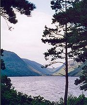
. The county consists chiefly of low mountains, with a deeply indented coastline forming natural lough
Lough
A lough is a body of water and is either:* A lake* A sea lough, which may be a fjord, estuary, bay, or sea inlet.It can also be used as a surname, with various pronunciations: law, loch, low, lowe, loth, loff....
s, of which both Lough Swilly
Lough Swilly
Lough Swilly in Ireland is a glacial fjord or sea inlet lying between the western side of the Inishowen Peninsula and the Fanad Peninsula, in County Donegal. Along with Carlingford Lough and Killary Harbour it is one of three known glacial fjords in Ireland....
and Lough Foyle
Lough Foyle
Lough Foyle, sometimes Loch Foyle , is the estuary of the River Foyle in Ulster. It starts where the Foyle leaves Derry. It separates the Inishowen Peninsula in County Donegal, Republic of Ireland from County Londonderry in Northern Ireland.-Transport:...
are the most notable. The famous mountains (often known as 'the Hills of Donegal') consist of two major ranges, the Derryveagh Mountains
Derryveagh Mountains
The Derryveagh Mountains is the major mountain range in County Donegal, Ireland. It makes up much of the landmass of the county, and is the area of Ireland with the lowest population density. The mountains separate the coastal parts of the county, such as Gweedore and Glenties, from the major...
in the north and the Bluestack Mountains
Bluestack Mountains
The Bluestack Mountains or Blue Stack Mountains, also called the Croaghgorms , are the major mountain range in the south of County Donegal, Ireland. They provide a barrier between the south of the county, such as Donegal Town and Ballyshannon, and the towns to the north and west such as Dungloe and...
in the south, with Mount Errigal
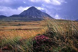
Mount Errigal
Mount Errigal, or simply Errigal is a mountain near Gweedore in County Donegal, Republic of Ireland. It is the tallest peak of the Derryveagh Mountains, the tallest peak in County Donegal, and the 76th tallest peak in Ireland. Errigal is also the most southern, steepest and highest of the...
at 749 metres (2,457 ft) the highest peak. The Slieve League
Slieve League
Slieve League, sometimes Slieve Leag or Slieve Liag , is a mountain on the Atlantic coast of County Donegal, Republic of Ireland. At , it has Ireland's highest sea cliffs...
cliffs are the sixth-highest sea cliffs in Europe
Europe
Europe is, by convention, one of the world's seven continents. Comprising the westernmost peninsula of Eurasia, Europe is generally 'divided' from Asia to its east by the watershed divides of the Ural and Caucasus Mountains, the Ural River, the Caspian and Black Seas, and the waterways connecting...
, while Donegal's Malin Head
Malin Head
Malin Head , on the Inishowen Peninsula, County Donegal, is usually given as the most northerly headland of the mainland of Ireland . In fact, the most northerly point is actually a headland named Banba's Crown on the Inishowen Peninsula about 2 km to the northeast...
is the most northerly point on the island of Ireland.
The climate is temperate and dominated by the Gulf Stream
Gulf Stream
The Gulf Stream, together with its northern extension towards Europe, the North Atlantic Drift, is a powerful, warm, and swift Atlantic ocean current that originates at the tip of Florida, and follows the eastern coastlines of the United States and Newfoundland before crossing the Atlantic Ocean...
, with warm, damp summers and mild wet winters. Two permanently inhabited islands, Arranmore
Arranmore
Árainn Mhór is the largest inhabited island of County Donegal, and the second largest in all of Ireland, with a population of 528 in 2006, down from 543 in 2002, and over 600 in 1996. The island is part of the Donegal Gaeltacht...
and Tory Island
Tory Island
Toraigh is an inhabited island 14.5 km off the northwest coast of County Donegal, Ireland. It is also known in Irish as Oileán Thoraigh, Oileán Thoraí or Oileán Thúr Rí.-Language:The main spoken language on the island is Irish, but English is also understood...
, lie off the coast, along with a large number of islands with only transient inhabitants. Ireland's second longest river, the Erne
River Erne
The River Erne , in the northwest of Ireland, rises in Beaghy Lough, two miles south of Stradone in County Cavan and flows 64 miles through Lough Gowna, Lough Oughter and Upper and Lower Lough Erne, County Fermanagh, to the sea at Ballyshannon, County Donegal...
, enters Donegal Bay
Donegal Bay
Donegal Bay is an inlet in the northwest of Ireland. Three counties – Donegal to the north and west, Leitrim and Sligo to the south – have shorelines on the bay, which is bounded on the west by the Atlantic Ocean...
near the town of Ballyshannon
Ballyshannon
Ballyshannon is a town in County Donegal, Ireland. It is located where the N3 and N15 cross the River Erne, and claims to be the oldest town in Ireland.-Location:...
. The River Erne
River Erne
The River Erne , in the northwest of Ireland, rises in Beaghy Lough, two miles south of Stradone in County Cavan and flows 64 miles through Lough Gowna, Lough Oughter and Upper and Lower Lough Erne, County Fermanagh, to the sea at Ballyshannon, County Donegal...
, along with other Donegal waterways, has been dammed to produce hydroelectric
Hydroelectricity
Hydroelectricity is the term referring to electricity generated by hydropower; the production of electrical power through the use of the gravitational force of falling or flowing water. It is the most widely used form of renewable energy...
power. The River Foyle
River Foyle
The River Foyle is a river in west Ulster in the northwest of Ireland, which flows from the confluence of the rivers Finn and Mourne at the towns of Lifford in County Donegal, Republic of Ireland, and Strabane in County Tyrone, Northern Ireland. From here it flows to the City of Derry, where it...
separates part of County Donegal from parts of both counties Londonderry
County Londonderry
The place name Derry is an anglicisation of the old Irish Daire meaning oak-grove or oak-wood. As with the city, its name is subject to the Derry/Londonderry name dispute, with the form Derry preferred by nationalists and Londonderry preferred by unionists...
and Tyrone
County Tyrone
Historically Tyrone stretched as far north as Lough Foyle, and comprised part of modern day County Londonderry east of the River Foyle. The majority of County Londonderry was carved out of Tyrone between 1610-1620 when that land went to the Guilds of London to set up profit making schemes based on...
.
Botany
A survey of the macroscopic marine algaeAlgae
Algae are a large and diverse group of simple, typically autotrophic organisms, ranging from unicellular to multicellular forms, such as the giant kelps that grow to 65 meters in length. They are photosynthetic like plants, and "simple" because their tissues are not organized into the many...
of County Donegal was published in 2003. The survey was compiled using the algal records held in the herbaria of the following institutions: the Ulster Museum
Ulster Museum
The Ulster Museum, located in the Botanic Gardens in Belfast, has around 8,000 square metres of public display space, featuring material from the collections of fine art and applied art, archaeology, ethnography, treasures from the Spanish Armada, local history, numismatics, industrial...
in Stranmillis
Stranmillis
Stranmillis is an area in south Belfast, Northern Ireland. It is also an electoral ward for Belfast City Council, part of the Laganbank district electoral area. As part of the Queen's Quarter, it is the location for prominent attractions such as the Ulster Museum and Botanic Gardens and is popular...
, Belfast
Belfast
Belfast is the capital of and largest city in Northern Ireland. By population, it is the 14th biggest city in the United Kingdom and second biggest on the island of Ireland . It is the seat of the devolved government and legislative Northern Ireland Assembly...
; Trinity College
Trinity College, Dublin
Trinity College, Dublin , formally known as the College of the Holy and Undivided Trinity of Queen Elizabeth near Dublin, was founded in 1592 by letters patent from Queen Elizabeth I as the "mother of a university", Extracts from Letters Patent of Elizabeth I, 1592: "...we...found and...
, Dublin; University College, Galway; and the Natural History Museum in South Kensington
South Kensington
South Kensington is a district in the Royal Borough of Kensington and Chelsea in London. It is a built-up area located 2.4 miles west south-west of Charing Cross....
, London
London
London is the capital city of :England and the :United Kingdom, the largest metropolitan area in the United Kingdom, and the largest urban zone in the European Union by most measures. Located on the River Thames, London has been a major settlement for two millennia, its history going back to its...
.
History
Tuath
Túath is an Old Irish word, often translated as "people" or "nation". It is cognate with the Welsh and Breton tud , and with the Germanic þeudō ....
of Tír Chonaill and the earldom that succeeded it.
County Donegal is famous for being the home of the once mighty Clann Dálaigh, whose most famous branch were the Clann Ó Domhnaill, better known in English
English language
English is a West Germanic language that arose in the Anglo-Saxon kingdoms of England and spread into what was to become south-east Scotland under the influence of the Anglian medieval kingdom of Northumbria...
as the O'Donnell Clan
O'Donnell dynasty
O'Donnell , which is derived from the forename Domhnaill were an ancient and powerful Irish family, kings, princes, and lords of Tír Chonaill in early times, and the chief allies and sometimes...
. Until around 1600, the O'Donnells were one of Ireland's richest and most powerful Gaelic
Gaelic Ireland
Gaelic Ireland is the name given to the period when a Gaelic political order existed in Ireland. The order continued to exist after the arrival of the Anglo-Normans until about 1607 AD...
(native Irish) ruling-families. Within the Province of Ulster
Ulster
Ulster is one of the four provinces of Ireland, located in the north of the island. In ancient Ireland, it was one of the fifths ruled by a "king of over-kings" . Following the Norman invasion of Ireland, the ancient kingdoms were shired into a number of counties for administrative and judicial...
only the Clann Uí Néill (known in English as the O'Neill Clan
O'Neill dynasty
The O'Neill dynasty is a group of families that have held prominent positions and titles throughout European history. The O'Neills take their name from Niall Glúndub, an early 10th century High King of Ireland from the Cenél nEógain...
) of modern County Tyrone
County Tyrone
Historically Tyrone stretched as far north as Lough Foyle, and comprised part of modern day County Londonderry east of the River Foyle. The majority of County Londonderry was carved out of Tyrone between 1610-1620 when that land went to the Guilds of London to set up profit making schemes based on...
were more powerful. The O'Donnells were Ulster's second most powerful clan or ruling-family from the early 13th-century through to the start of the 17th-century. For several centuries the O'Donnells ruled Tír Chonaill, a Gaelic kingdom in West Ulster that covered almost all of modern County Donegal. The head of the O'Donnell family had the titles An Ó Domhnaill (meaning The O'Donnell in English) and Rí Thír Chonaill (meaning King of Tír Chonaill in English). Based at Donegal Castle
Donegal castle
Donegal Castle is a castle situated in the centre of Donegal town, County Donegal in the northwest of Ireland. For most of the last two centuries, the majority of the buildings lay in ruins but the castle was almost fully restored in the late 1990s....
in Dún na nGall (modern Donegal Town
Donegal
Donegal or Donegal Town is a town in County Donegal, Ireland. Its name, which was historically written in English as Dunnagall or Dunagall, translates from Irish as "stronghold of the foreigners" ....
), the O'Donnell Kings of Tír Chonaill were traditionally inaugurated at Doon Rock near Kilmacrenan
Kilmacrenan
Kilmacrenan is a small village located in County Donegal on the north west coast of Ireland. The village had a population of 430 in the 2002 census, however the village's population has increased rapidily over the last decade as a result of people leaving Letterkenny and living in the countryside...
. O'Donnell royal or chiefly power was finally ended in what was then the newly created County Donegal in September, 1607, following the Flight of the Earls
Flight of the Earls
The Flight of the Earls took place on 14 September 1607, when Hugh Ó Neill of Tír Eóghain, Rory Ó Donnell of Tír Chonaill and about ninety followers left Ireland for mainland Europe.-Background to the exile:...
from near Rathmullan
Rathmullan
Rathmullan is a small seaside village on the Fanad Peninsula in County Donegal, part of the Province of Ulster in Ireland. It is situated on the western shore of Lough Swilly, 11 km north-east of Ramelton and 12 km east of Milford...
. The modern County Arms of Donegal (dating from the early 1970s) was influenced by the design of the old O'Donnell royal arms. The County Arms is the official coat of arms
Coat of arms
A coat of arms is a unique heraldic design on a shield or escutcheon or on a surcoat or tabard used to cover and protect armour and to identify the wearer. Thus the term is often stated as "coat-armour", because it was anciently displayed on the front of a coat of cloth...
of both County Donegal and Donegal County Council.
The modern County Donegal was shire
Shire
A shire is a traditional term for a division of land, found in the United Kingdom and in Australia. In parts of Australia, a shire is an administrative unit, but it is not synonymous with "county" there, which is a land registration unit. Individually, or as a suffix in Scotland and in the far...
d by order of the English
England
England is a country that is part of the United Kingdom. It shares land borders with Scotland to the north and Wales to the west; the Irish Sea is to the north west, the Celtic Sea to the south west, with the North Sea to the east and the English Channel to the south separating it from continental...
Crown in 1585. The English authorities at Dublin Castle
Dublin Castle
Dublin Castle off Dame Street, Dublin, Ireland, was until 1922 the fortified seat of British rule in Ireland, and is now a major Irish government complex. Most of it dates from the 18th century, though a castle has stood on the site since the days of King John, the first Lord of Ireland...
formed the new county by amalgamating the old Kingdom of Tír Chonaill with the old Lordship of Inishowen
Inishowen
Inishowen is a peninsula in County Donegal, part of the Province of Ulster in the north of Ireland. It is also the largest peninsula in all of Ireland. Inishowen is a picturesque location with a rich history...
. However, the English authorities were unable to establish control over Tír Chonaill and Inishowen until after the Battle of Kinsale
Siege of Kinsale
The Siege or Battle of Kinsale was the ultimate battle in England's conquest of Gaelic Ireland. It took place during the reign of Queen Elizabeth I, at the climax of the Nine Years War - a campaign by Aodh Mór Ó Néill, Aodh Rua Ó Dónaill and other Irish clan leaders against English rule...
in 1602. Full control over the new County Donegal was only achieved after the Flight of the Earls
Flight of the Earls
The Flight of the Earls took place on 14 September 1607, when Hugh Ó Neill of Tír Eóghain, Rory Ó Donnell of Tír Chonaill and about ninety followers left Ireland for mainland Europe.-Background to the exile:...
in September, 1607. The county was one of those 'planted' during the Plantation of Ulster
Plantation of Ulster
The Plantation of Ulster was the organised colonisation of Ulster—a province of Ireland—by people from Great Britain. Private plantation by wealthy landowners began in 1606, while official plantation controlled by King James I of England and VI of Scotland began in 1609...
from around 1610 onwards.
County Donegal was one of the worst affected parts of Ulster
Ulster
Ulster is one of the four provinces of Ireland, located in the north of the island. In ancient Ireland, it was one of the fifths ruled by a "king of over-kings" . Following the Norman invasion of Ireland, the ancient kingdoms were shired into a number of counties for administrative and judicial...
during the Great Famine of the late 1840s in Ireland
Ireland
Ireland is an island to the northwest of continental Europe. It is the third-largest island in Europe and the twentieth-largest island on Earth...
. Vast swathes of the county were devastated by this catastrophe, many areas becoming permanently depopulated. Vast numbers of County Donegal's people emigrated at this time, chiefly through the Port of Derry
Londonderry Port
Londonderry Port at Lisahally is a port near Derry, Northern Ireland. It is the United Kingdom’s most westerly port, has capacity for 30,000 ton vessels and accepts cruise ships. The current port is on the east bank of the River Foyle at the southern end of Lough Foyle, by the small village of...
. Huge numbers of the county's people who emigrated were to settle in Glasgow
Glasgow
Glasgow is the largest city in Scotland and third most populous in the United Kingdom. The city is situated on the River Clyde in the country's west central lowlands...
in southern Scotland
Scotland
Scotland is a country that is part of the United Kingdom. Occupying the northern third of the island of Great Britain, it shares a border with England to the south and is bounded by the North Sea to the east, the Atlantic Ocean to the north and west, and the North Channel and Irish Sea to the...
.
The Partition of Ireland
Partition of Ireland
The partition of Ireland was the division of the island of Ireland into two distinct territories, now Northern Ireland and the Republic of Ireland . Partition occurred when the British Parliament passed the Government of Ireland Act 1920...
in the early 1920s was to have a massive direct impact on County Donegal. Partition
Partition (politics)
In politics, a partition is a change of political borders cutting through at least one territory considered a homeland by some community. That change is done primarily by diplomatic means, and use of military force is negligible....
cut the county off, economically and administratively, from Derry
Derry
Derry or Londonderry is the second-biggest city in Northern Ireland and the fourth-biggest city on the island of Ireland. The name Derry is an anglicisation of the Irish name Doire or Doire Cholmcille meaning "oak-wood of Colmcille"...
, which had acted for centuries as the county's main port, transport hub and financial centre. Derry, together with West Tyrone, was henceforward in a new, different jurisdiction
Jurisdiction
Jurisdiction is the practical authority granted to a formally constituted legal body or to a political leader to deal with and make pronouncements on legal matters and, by implication, to administer justice within a defined area of responsibility...
officially called Northern Ireland
Northern Ireland
Northern Ireland is one of the four countries of the United Kingdom. Situated in the north-east of the island of Ireland, it shares a border with the Republic of Ireland to the south and west...
. Partition also meant that County Donegal was now almost entirely cut off from the rest of the jurisdiction it now found itself in, the new dominion
Dominion
A dominion, often Dominion, refers to one of a group of autonomous polities that were nominally under British sovereignty, constituting the British Empire and British Commonwealth, beginning in the latter part of the 19th century. They have included Canada, Australia, New Zealand, Newfoundland,...
called the Irish Free State
Irish Free State
The Irish Free State was the state established as a Dominion on 6 December 1922 under the Anglo-Irish Treaty, signed by the British government and Irish representatives exactly twelve months beforehand...
. This dominion became fully independent in April 1949 when it left the Commonwealth
Commonwealth of Nations
The Commonwealth of Nations, normally referred to as the Commonwealth and formerly known as the British Commonwealth, is an intergovernmental organisation of fifty-four independent member states...
and became the Republic of Ireland
Republic of Ireland
Ireland , described as the Republic of Ireland , is a sovereign state in Europe occupying approximately five-sixths of the island of the same name. Its capital is Dublin. Ireland, which had a population of 4.58 million in 2011, is a constitutional republic governed as a parliamentary democracy,...
. Only a few miles of the county is physically connected by land to the rest of the Republic. The existence of this border, cutting Donegal off from her natural hinterlands in Derry City and West Tyrone, has greatly exacerbated the economic difficulties of the county since partition. The county's economy is particularly susceptible, just like that of Derry City, to the currency fluctuations of the Euro
Euro
The euro is the official currency of the eurozone: 17 of the 27 member states of the European Union. It is also the currency used by the Institutions of the European Union. The eurozone consists of Austria, Belgium, Cyprus, Estonia, Finland, France, Germany, Greece, Ireland, Italy, Luxembourg,...
against Sterling
Pound sterling
The pound sterling , commonly called the pound, is the official currency of the United Kingdom, its Crown Dependencies and the British Overseas Territories of South Georgia and the South Sandwich Islands, British Antarctic Territory and Tristan da Cunha. It is subdivided into 100 pence...
.
Added to all this, in the late twentieth-century, County Donegal was, by the standards of the rest of the Republic of Ireland, to be adversely affected by The Troubles
The Troubles
The Troubles was a period of ethno-political conflict in Northern Ireland which spilled over at various times into England, the Republic of Ireland, and mainland Europe. The duration of the Troubles is conventionally dated from the late 1960s and considered by many to have ended with the Belfast...
in Northern Ireland. The county was to suffer several bombings and at least two assassinations. In June 1987, Constable Samuel McClean, a Donegal man who was a serving member of the R.U.C.
Royal Ulster Constabulary
The Royal Ulster Constabulary was the name of the police force in Northern Ireland from 1922 to 2000. Following the awarding of the George Cross in 2000, it was subsequently known as the Royal Ulster Constabulary GC. It was founded on 1 June 1922 out of the Royal Irish Constabulary...
, was shot dead by the I.R.A.
Irish Republican Army
The Irish Republican Army was an Irish republican revolutionary military organisation. It was descended from the Irish Volunteers, an organisation established on 25 November 1913 that staged the Easter Rising in April 1916...
at his family home near Drumkeen. In May 1991, the prominent Sinn Féin
Sinn Féin
Sinn Féin is a left wing, Irish republican political party in Ireland. The name is Irish for "ourselves" or "we ourselves", although it is frequently mistranslated as "ourselves alone". Originating in the Sinn Féin organisation founded in 1905 by Arthur Griffith, it took its current form in 1970...
politician Councillor
Councillor
A councillor or councilor is a member of a local government council, such as a city council.Often in the United States, the title is councilman or councilwoman.-United Kingdom:...
Eddie Fullerton
Eddie Fullerton
Edward "Eddie" Fullerton was a Sinn Féin councillor from County Donegal, Ireland. He was assassinated at his Buncrana home in May 1991 by members of the Ulster Defence Association....
was assassinated by the U.D.A.
Ulster Defence Association
The Ulster Defence Association is the largest although not the deadliest loyalist paramilitary and vigilante group in Northern Ireland. It was formed in September 1971 and undertook a campaign of almost twenty-four years during "The Troubles"...
at his home in Buncrana. This added further to the economic and social difficulties of the county. However, the Good Friday Agreement
Belfast Agreement
The Good Friday Agreement or Belfast Agreement , sometimes called the Stormont Agreement, was a major political development in the Northern Ireland peace process...
(G.F.A.) of April 1998 has been of great benefit to the county.
It has been labelled the 'forgotten county' by its own politicians, owing to the increasing regularity with which it is ignored by the Irish Government
Irish Government
The Government of Ireland is the cabinet that exercises executive authority in Ireland.-Members of the Government:Membership of the Government is regulated fundamentally by the Constitution of Ireland. The Government is headed by a prime minister called the Taoiseach...
, even in times of crisis.
Irish language
Much of the county is seen as being a bastion of Gaelic culture and the Irish languageIrish language
Irish , also known as Irish Gaelic, is a Goidelic language of the Indo-European language family, originating in Ireland and historically spoken by the Irish people. Irish is now spoken as a first language by a minority of Irish people, as well as being a second language of a larger proportion of...
, the county holding the second-largest Gaeltacht
Gaeltacht
is the Irish language word meaning an Irish-speaking region. In Ireland, the Gaeltacht, or an Ghaeltacht, refers individually to any, or collectively to all, of the districts where the government recognises that the Irish language is the predominant language, that is, the vernacular spoken at home...
area in the country with a population of 24,504. 16% of the county's population lives in the Gaeltacht
Gaeltacht
is the Irish language word meaning an Irish-speaking region. In Ireland, the Gaeltacht, or an Ghaeltacht, refers individually to any, or collectively to all, of the districts where the government recognises that the Irish language is the predominant language, that is, the vernacular spoken at home...
. Gweedore is the largest Irish-speaking parish with over 4,000 inhabitants. All schools in the region use Irish as the language of instruction. One of the N.U.I.G.
National University of Ireland, Galway
The National University of Ireland, Galway is a constituent university of the National University of Ireland...
's constituent colleges, Acadamh na hOllscolaíochta Gaeilge
Acadamh na hOllscolaíochta Gaeilge
Acadamh na hOllscolaíochta Gaeilge was established under the auspices of the National University of Ireland, Galway in 2004, to develop Gaelic-medium education...
, is based in Gweedore
Gweedore
Gweedore is an Irish-speaking district located on the Atlantic coast of County Donegal, part of the Province of Ulster in Ireland. Gweedore stretches some 16 miles from Meenaclady in the north to Crolly in the south and around 9 miles from Dunlewey in the east to Magheraclogher in the west, and...
. The version of the Irish language
Irish language
Irish , also known as Irish Gaelic, is a Goidelic language of the Indo-European language family, originating in Ireland and historically spoken by the Irish people. Irish is now spoken as a first language by a minority of Irish people, as well as being a second language of a larger proportion of...
spoken in County Donegal is Ulster Irish
Ulster Irish
Ulster Irish is the dialect of the Irish language spoken in the Province of Ulster. The largest Gaeltacht region today is in County Donegal, so that the term Donegal Irish is often used synonymously. Nevertheless, records of the language as it was spoken in other counties do exist, and help provide...
.
Government and Politics
Donegal County CouncilDonegal County Council
Donegal County Council is the local authority which is responsible for County Donegal in Ireland. The Council is responsible for Housing and Community, Roads and Transportation, Urban planning and Development, Amenity and Culture, and Environment. The head of the council has the title of Mayor...
(which has officially been in existence since 1899) has responsibility for local administration, and is headquartered at the County House in Lifford
Lifford
Lifford is the county town of County Donegal, Ireland. It is the administrative capital of the county and the seat of Donegal County Council, although the town of Letterkenny is often mistaken for fulfilling this role...
. The County Council
County council
A county council is the elected administrative body governing an area known as a county. This term has slightly different meanings in different countries.-United Kingdom:...
runs alongside Town Councils in Letterkenny
Letterkenny
Letterkenny , with a population of 17,568, is the largest town in County Donegal, part of the Province of Ulster in Ireland. The town is located on the River Swilly...
, Bundoran
Bundoran
Bundoran is a town in County Donegal, part of the Province of Ulster in the north of Ireland. The town is located on the N15 road near Ballyshannon, 3 hours drive from Dublin and around two and a quarter hours drive from Belfast...
, Ballyshannon
Ballyshannon
Ballyshannon is a town in County Donegal, Ireland. It is located where the N3 and N15 cross the River Erne, and claims to be the oldest town in Ireland.-Location:...
and Buncrana. Both the County Council and Town Councils have elections every five years (alongside local elections nationally, and elections to the European Parliament
European Parliament
The European Parliament is the directly elected parliamentary institution of the European Union . Together with the Council of the European Union and the Commission, it exercises the legislative function of the EU and it has been described as one of the most powerful legislatures in the world...
), the last of which took place on the 5 June 2009. Twenty nine councillors are elected using the system of Proportional representation
Proportional representation
Proportional representation is a concept in voting systems used to elect an assembly or council. PR means that the number of seats won by a party or group of candidates is proportionate to the number of votes received. For example, under a PR voting system if 30% of voters support a particular...
-Singe Transferable Vote (STV), across five electoral areas (Inishowen
Inishowen
Inishowen is a peninsula in County Donegal, part of the Province of Ulster in the north of Ireland. It is also the largest peninsula in all of Ireland. Inishowen is a picturesque location with a rich history...
– 7 seats, Letterkenny
Letterkenny
Letterkenny , with a population of 17,568, is the largest town in County Donegal, part of the Province of Ulster in Ireland. The town is located on the River Swilly...
– 7 seats, Donegal
Donegal
Donegal or Donegal Town is a town in County Donegal, Ireland. Its name, which was historically written in English as Dunnagall or Dunagall, translates from Irish as "stronghold of the foreigners" ....
– 5 seats, Stranorlar
Stranorlar
Stranorlar is a small town in the Finn Valley of County Donegal, in Ireland. Stranorlar and Ballybofey form the Twin Towns.-Transport:...
– 5 seats, and Glenties
Glenties
Glenties is a village in the northwest of Ireland in central County Donegal. It is situated where two glens meet, northwest of the Blue Stack Mountains, near the confluence of two rivers. Glenties is the largest centre of population in the parish of Iniskeel...
– 5 seats.
For General election
General election
In a parliamentary political system, a general election is an election in which all or most members of a given political body are chosen. The term is usually used to refer to elections held for a nation's primary legislative body, as distinguished from by-elections and local elections.The term...
s, the county is divided into two constituencies, Donegal South West
Donegal South West (Dáil Éireann constituency)
Donegal South–West is a parliamentary constituency represented in Dáil Éireann, the lower house of the Irish parliament or Oireachtas. The constituency elects 3 deputies...
and Donegal North East
Donegal North East (Dáil Éireann constituency)
Donegal North–East is a parliamentary constituency represented in Dáil Éireann, the lower house of the Irish parliament or Oireachtas. The constituency elects 3 deputies...
, with both having three representatives in Dáil Éireann
Dáil Éireann
Dáil Éireann is the lower house, but principal chamber, of the Oireachtas , which also includes the President of Ireland and Seanad Éireann . It is directly elected at least once in every five years under the system of proportional representation by means of the single transferable vote...
. For elections to the European Parliament
European Parliament
The European Parliament is the directly elected parliamentary institution of the European Union . Together with the Council of the European Union and the Commission, it exercises the legislative function of the EU and it has been described as one of the most powerful legislatures in the world...
, the county is part of the North–West constituency (formerly Connacht–Ulster).
Access
An extensive rail network used to exist throughout the county and was mainly operated by the County Donegal Railways Joint CommitteeCounty Donegal Railways Joint Committee
The County Donegal Railways Joint Committee operated an extensive 3 foot gauge railway system serving county Donegal, Ireland,from 1906 until 1960...
and the Londonderry and Lough Swilly Railway Company
Londonderry and Lough Swilly Railway
The Londonderry and Lough Swilly Railway Company is an Irish public transport and freight company incorporated in June 1853. Despite its name it operates no railway services. It formerly operated 99 miles of railways but closed its last line in July 1953...
(known as the L. & L.S.R. or the Lough Swilly Company for short). The Great Northern Railway (Ireland)
Great Northern Railway (Ireland)
The Great Northern Railway was an Irish gauge railway company in Ireland.The Great Northern was formed in 1876 by a merger of the Irish North Western Railway , Northern Railway of Ireland, and Ulster Railway. The Ulster Railway was the GNRI's oldest constituent, having opened between Belfast and...
L.t.d. (the G.N.R.) also ran a line from Strabane
Strabane
Strabane , historically spelt Straban,is a town in west County Tyrone, Northern Ireland. It contains the headquarters of Strabane District Council....
through The Laggan, a district in the east of the county, along the River Foyle
River Foyle
The River Foyle is a river in west Ulster in the northwest of Ireland, which flows from the confluence of the rivers Finn and Mourne at the towns of Lifford in County Donegal, Republic of Ireland, and Strabane in County Tyrone, Northern Ireland. From here it flows to the City of Derry, where it...
into Derry. Even though the railways in Donegal are fondly remembered, the network was completely closed by 1960. Today, the closest railway station to the county is Waterside Station
Londonderry railway station
Londonderry/Derry Railway Station, known commonly as Waterside Railway Station, serves the city of Derry in Northern Ireland. The station is also used by residents of the west of County Londonderry, much of west Tyrone and County Donegal. It is operated by Northern Ireland Railways...
in the City of Derry, which is operated by Northern Ireland Railways (N.I.R.).
County Donegal is served by both Donegal Airport
Donegal Airport
Donegal Airport is located south-west of An Bun Beag , being located at Carrickfinn, a townland in The Rosses, a district in north-west County Donegal, Ireland. The small airport is located right on the county's north-west coast. It is about a 15 minute drive from Dungloe and Gweedore and 45...
, located at Carrickfinn in The Rosses
The Rosses
The Rosses is a geographical and social region in the west of County Donegal, Ireland, centred around the town of Dungloe, which acts as the educational, shopping and civil centre for the area...
in the west of the county, and by City of Derry Airport
City of Derry Airport
City of Derry Airport is an airport located northeast of Derry, Northern Ireland. It is located on the south bank of Lough Foyle, a short distance from the village of Eglinton and from the city centre...
, located at Eglinton
Eglinton, County Londonderry
Eglinton is a village in County Londonderry, Northern Ireland. It lies east of Derry, to which it serves as a sleeper village, and west of Limavady. Many inhabitants of the village work in Derry city and send their children to school there. Eglinton had a population of 3,165 people in the 2001...
to the east. The nearest main international airport to the county is Belfast International Airport
Belfast International Airport
Belfast International Airport is a major airport located northwest of Belfast in Northern Ireland. It was formerly known and is still referred to as Aldergrove Airport, after the village of the same name lying immediately to the west of the airport. Belfast International shares its runways with...
(popularly known as Aldergrove Airport), which is located to the east at Aldergrove, near Antrim Town
Antrim, County Antrim
Antrim is a town in County Antrim in the northeast of Northern Ireland, on the banks of the Six Mile Water, half a mile north-east of Lough Neagh. It had a population of 20,001 people in the 2001 Census. The town is the administrative centre of Antrim Borough Council...
, in County Antrim
County Antrim
County Antrim is one of six counties that form Northern Ireland, situated in the north-east of the island of Ireland. Adjoined to the north-east shore of Lough Neagh, the county covers an area of 2,844 km², with a population of approximately 616,000...
, around fifty-seven miles from Derry City and around seventy-five miles from Letterkenny.
Culture
Irish language
Irish , also known as Irish Gaelic, is a Goidelic language of the Indo-European language family, originating in Ireland and historically spoken by the Irish people. Irish is now spoken as a first language by a minority of Irish people, as well as being a second language of a larger proportion of...
spoken in Donegal shares many traits with Scottish Gaelic. The Irish spoken in the Donegal Gaeltacht
Gaeltacht
is the Irish language word meaning an Irish-speaking region. In Ireland, the Gaeltacht, or an Ghaeltacht, refers individually to any, or collectively to all, of the districts where the government recognises that the Irish language is the predominant language, that is, the vernacular spoken at home...
(Irish-speaking area) is of the Ulster dialect
Ulster Irish
Ulster Irish is the dialect of the Irish language spoken in the Province of Ulster. The largest Gaeltacht region today is in County Donegal, so that the term Donegal Irish is often used synonymously. Nevertheless, records of the language as it was spoken in other counties do exist, and help provide...
, while Inishowen
Inishowen
Inishowen is a peninsula in County Donegal, part of the Province of Ulster in the north of Ireland. It is also the largest peninsula in all of Ireland. Inishowen is a picturesque location with a rich history...
(parts of which only became English
English language
English is a West Germanic language that arose in the Anglo-Saxon kingdoms of England and spread into what was to become south-east Scotland under the influence of the Anglian medieval kingdom of Northumbria...
-speaking in the early 20th century) used the East Ulster dialect. Ulster Scots is often spoken in both the Finn Valley
River Finn
The River Finn is a river that flows through County Donegal in the Republic of Ireland and County Tyrone in Northern Ireland. It rises in Lough Finn in County Donegal and flows east through a deep mountain valley to Ballybofey and Stranorlar and on to the confluence with the River Mourne at Lifford...
and The Laggan district of East Donegal. Donegal Irish has a strong influence on learnt Irish
Irish language
Irish , also known as Irish Gaelic, is a Goidelic language of the Indo-European language family, originating in Ireland and historically spoken by the Irish people. Irish is now spoken as a first language by a minority of Irish people, as well as being a second language of a larger proportion of...
across Ulster.
Like other areas on the western seaboard of Ireland, Donegal has a distinctive fiddle tradition
Donegal fiddle tradition
The Donegal fiddle tradition is a type of Irish traditional music, based on a two-hundred year-old tradition of playing the fiddle in County Donegal, Ireland...
which is of world renown. Donegal is also well known for its songs which have, like the instrumental music, a distinctive sound. Donegal musical artists such as the bands Clannad
Clannad
Clannad are an Irish musical group, from Gaoth Dobhair, County Donegal. Their music has been variously described as bordering on folk and folk rock, Irish, Celtic and New Age, often incorporating elements of an even broader spectrum of smooth jazz and Gregorian chant...
and Altan and solo artist Enya
Enya
Enya is an Irish singer, instrumentalist and songwriter. Enya is an approximate transliteration of how Eithne is pronounced in the Donegal dialect of the Irish language, her native tongue.She began her musical career in 1980, when she briefly joined her family band Clannad before leaving to...
, all from Gaoth Dobhair, have had international success with traditional or traditional flavoured music. Donegal music has also influenced people not originally from the county including folk and pop singer Paul Brady
Paul Brady
Paul Joseph Brady is an Irish singer-songwriter, whose work straddles folk and pop. He was interested in a wide variety of music from an early age...
. Popular music
Popular music
Popular music belongs to any of a number of musical genres "having wide appeal" and is typically distributed to large audiences through the music industry. It stands in contrast to both art music and traditional music, which are typically disseminated academically or orally to smaller, local...
is also common, the county's most acclaimed rock artist being the Ballyshannon
Ballyshannon
Ballyshannon is a town in County Donegal, Ireland. It is located where the N3 and N15 cross the River Erne, and claims to be the oldest town in Ireland.-Location:...
-born Rory Gallagher
Rory Gallagher
William Rory Gallagher, ; 2 March 1948 – 14 June 1995, was an Irish blues-rock multi-instrumentalist, songwriter, and bandleader. Born in Ballyshannon, County Donegal, Ireland, and raised in Cork, Gallagher recorded solo albums throughout the 1970s and 1980s, after forming the band Taste...
.
Irish language
Irish , also known as Irish Gaelic, is a Goidelic language of the Indo-European language family, originating in Ireland and historically spoken by the Irish people. Irish is now spoken as a first language by a minority of Irish people, as well as being a second language of a larger proportion of...
and English
English language
English is a West Germanic language that arose in the Anglo-Saxon kingdoms of England and spread into what was to become south-east Scotland under the influence of the Anglian medieval kingdom of Northumbria...
. The famous Irish navvy
Navvy
Navvy is a shorter form of navigator or navigational engineer and is particularly applied to describe the manual labourers working on major civil engineering projects...
-turned-novelist Patrick MacGill
Patrick MacGill
Patrick MacGill was an Irish journalist, poet and novelist, known as "The Navvy Poet" because he had worked as a navvy before he began writing.MacGill was born in Glenties, County Donegal...
, author of many books about the experiences of Irish migrant itinerant
Itinerant
An itinerant is a person who travels from place to place with no fixed home. The term comes from the late 16th century: from late Latin itinerant , from the verb itinerari, from Latin iter, itiner ....
labourers in Britain
Great Britain
Great Britain or Britain is an island situated to the northwest of Continental Europe. It is the ninth largest island in the world, and the largest European island, as well as the largest of the British Isles...
at around the turn of the 20th century, such as The Rat Pit and the autobiographical Children of the Dead End, is from the Glenties
Glenties
Glenties is a village in the northwest of Ireland in central County Donegal. It is situated where two glens meet, northwest of the Blue Stack Mountains, near the confluence of two rivers. Glenties is the largest centre of population in the parish of Iniskeel...
area. There is a literary summer school in Glenties
Glenties
Glenties is a village in the northwest of Ireland in central County Donegal. It is situated where two glens meet, northwest of the Blue Stack Mountains, near the confluence of two rivers. Glenties is the largest centre of population in the parish of Iniskeel...
named in his honour. The novelist and socialist
Socialism
Socialism is an economic system characterized by social ownership of the means of production and cooperative management of the economy; or a political philosophy advocating such a system. "Social ownership" may refer to any one of, or a combination of, the following: cooperative enterprises,...
politician Peadar O'Donnell
Peadar O'Donnell
Peadar O'Donnell was an Irish republican and socialist activist and writer.-Early life:Peadar O'Donnell was born into an Irish speaking family in Dungloe, County Donegal in northwest Ireland, in 1893. He attended St. Patrick's College, Dublin, where he trained as a teacher...
hails from The Rosses
The Rosses
The Rosses is a geographical and social region in the west of County Donegal, Ireland, centred around the town of Dungloe, which acts as the educational, shopping and civil centre for the area...
in west Donegal. The Poet William Allingham
William Allingham
William Allingham was an Irish man of letters and a poet.-Biography:He was born in Ballyshannon, County Donegal, Ireland and was the son of the manager of a local bank who was of English descent...
was also from Ballyshannon. Modern exponents include the Inishowen
Inishowen
Inishowen is a peninsula in County Donegal, part of the Province of Ulster in the north of Ireland. It is also the largest peninsula in all of Ireland. Inishowen is a picturesque location with a rich history...
playwright and poet Frank McGuinness
Frank McGuinness
Professor Frank McGuinness is an award-winning Irish playwright and poet. As well as his own works, which include Observe the Sons of Ulster Marching Towards the Somme, he is recognised for a "strong record of adapting literary classics, having translated the plays of Racine, Sophocles, Ibsen and...
and the playwright Brian Friel
Brian Friel
Brian Friel is an Irish dramatist, author and director of the Field Day Theatre Company. He is considered to be the greatest living English-language dramatist, hailed by the English-speaking world as an "Irish Chekhov" and "the universally accented voice of Ireland"...
. Many of Friel's plays are set in the fictional Donegal town of Ballybeg
Ballybeg
Ballybeg is a generic name given to small Irish towns. The name comes from the Gaelic words Baile Beag which literally means Little Town...
.
Authors in Donegal have been creating works, like the Annals of the Four Masters
Annals of the Four Masters
The Annals of the Kingdom of Ireland or the Annals of the Four Masters are a chronicle of medieval Irish history...
, in Gaelic
Irish language
Irish , also known as Irish Gaelic, is a Goidelic language of the Indo-European language family, originating in Ireland and historically spoken by the Irish people. Irish is now spoken as a first language by a minority of Irish people, as well as being a second language of a larger proportion of...
and Latin
Latin
Latin is an Italic language originally spoken in Latium and Ancient Rome. It, along with most European languages, is a descendant of the ancient Proto-Indo-European language. Although it is considered a dead language, a number of scholars and members of the Christian clergy speak it fluently, and...
since the Early Middle Ages
Early Middle Ages
The Early Middle Ages was the period of European history lasting from the 5th century to approximately 1000. The Early Middle Ages followed the decline of the Western Roman Empire and preceded the High Middle Ages...
. The Irish philosopher John Toland
John Toland
John Toland was a rationalist philosopher and freethinker, and occasional satirist, who wrote numerous books and pamphlets on political philosophy and philosophy of religion, which are early expressions of the philosophy of the Age of Enlightenment...
was born in Inishowen
Inishowen
Inishowen is a peninsula in County Donegal, part of the Province of Ulster in the north of Ireland. It is also the largest peninsula in all of Ireland. Inishowen is a picturesque location with a rich history...
in 1670. He was thought of as the original freethinker
Freethought
Freethought is a philosophical viewpoint that holds that opinions should be formed on the basis of science, logic, and reason, and should not be influenced by authority, tradition, or other dogmas...
by George Berkeley
George Berkeley
George Berkeley , also known as Bishop Berkeley , was an Irish philosopher whose primary achievement was the advancement of a theory he called "immaterialism"...
. Toland was also instrumental in the spread of freemasonry throughout Continental Europe
Continental Europe
Continental Europe, also referred to as mainland Europe or simply the Continent, is the continent of Europe, explicitly excluding European islands....
. In modern Irish
Irish language
Irish , also known as Irish Gaelic, is a Goidelic language of the Indo-European language family, originating in Ireland and historically spoken by the Irish people. Irish is now spoken as a first language by a minority of Irish people, as well as being a second language of a larger proportion of...
Donegal has produced famous, and sometimes controversial, authors such as the brothers Séamus Ó Grianna
Séamus Ó Grianna
Séamus Ó Grianna was an Irish writer, who used the pen name Máire. Born into a family of poets and storytellers in Ranafast, County Donegal, he attended local primary school until the age of 14. He spent several years at home and as a seasonal worker in Scotland. He attended an Irish language...
and Seosamh Mac Grianna
Seosamh Mac Grianna
Seosamh Mac Grianna was an Irish writer, in his early career under the pen-name Iolann Fionn. He was born into a family of poets and storytellers, which included his brothers Séamus Ó Grianna and Seán Bán Mac Grianna, in Ranafast, County Donegal, at a time of linguistic and cultural...
from The Rosses
The Rosses
The Rosses is a geographical and social region in the west of County Donegal, Ireland, centred around the town of Dungloe, which acts as the educational, shopping and civil centre for the area...
and the contemporary (and controversial) Irish-language poet Cathal Ó Searcaigh
Cathal Ó Searcaigh
Cathal Ó Searcaigh is an Irish poet who writes in the Irish language .Ó Searcaigh was born in Gort a' Choirce, a town in the Gaeltacht region of Donegal, and lives at the foot of Mount Errigal...
from Gortahork
Gortahork
Gort an Choirce or Gort a' Choirce is a village and townland in the northwest of County Donegal, Ireland. It is a lively Gaeltacht community, where the Irish language is still the main language of the area...
in Cloughaneely, and where he is known to locals as Gúrú na gCnoc ('the Guru of the Hills').
Although approximately 85% of its population is Catholic, County Donegal also has a sizeable Protestant
Protestantism
Protestantism is one of the three major groupings within Christianity. It is a movement that began in Germany in the early 16th century as a reaction against medieval Roman Catholic doctrines and practices, especially in regards to salvation, justification, and ecclesiology.The doctrines of the...
minority. Most Donegal Protestants would trace their ancestors to settlers who arrived during the Plantation of Ulster
Plantation of Ulster
The Plantation of Ulster was the organised colonisation of Ulster—a province of Ireland—by people from Great Britain. Private plantation by wealthy landowners began in 1606, while official plantation controlled by King James I of England and VI of Scotland began in 1609...
in the early seventeenth-century. The Church of Ireland
Church of Ireland
The Church of Ireland is an autonomous province of the Anglican Communion. The church operates in all parts of Ireland and is the second largest religious body on the island after the Roman Catholic Church...
is the largest Protestant denomination but is closely rivalled by a large number of Presbyterians
Presbyterianism
Presbyterianism refers to a number of Christian churches adhering to the Calvinist theological tradition within Protestantism, which are organized according to a characteristic Presbyterian polity. Presbyterian theology typically emphasizes the sovereignty of God, the authority of the Scriptures,...
. The areas of Donegal with the highest percentage of Protestants are The Laggan area of East Donegal around Raphoe
Raphoe
Raphoe is a town in County Donegal, part of the province of Ulster in Ireland. It is the main town in the fertile district of East Donegal known as the Laggan, as well as giving its name to the Roman Catholic Diocese of Raphoe and the Church of Ireland Diocese of Derry and Raphoe.-Name:Raphoe,...
, the Finn Valley and areas around Ramelton, Milford and Dunfanaghy – where their proportion reaches up to 30–45 percent. There is also a large Protestant population between Donegal Town
Donegal
Donegal or Donegal Town is a town in County Donegal, Ireland. Its name, which was historically written in English as Dunnagall or Dunagall, translates from Irish as "stronghold of the foreigners" ....
and Ballyshannon
Ballyshannon
Ballyshannon is a town in County Donegal, Ireland. It is located where the N3 and N15 cross the River Erne, and claims to be the oldest town in Ireland.-Location:...
in the south of the county. In absolute terms, Letterkenny
Letterkenny
Letterkenny , with a population of 17,568, is the largest town in County Donegal, part of the Province of Ulster in Ireland. The town is located on the River Swilly...
has the largest number of Protestants (over 1000) and is the most Presbyterian town (among those settlements with more than 3000 people) in the Republic of Ireland
Republic of Ireland
Ireland , described as the Republic of Ireland , is a sovereign state in Europe occupying approximately five-sixths of the island of the same name. Its capital is Dublin. Ireland, which had a population of 4.58 million in 2011, is a constitutional republic governed as a parliamentary democracy,...
. Some County Donegal Protestants (mainly those concentrated in The Laggan and the Donegal Town/Ballintra areas) are members of the Orange Order
Orange Institution
The Orange Institution is a Protestant fraternal organisation based mainly in Northern Ireland and Scotland, though it has lodges throughout the Commonwealth and United States. The Institution was founded in 1796 near the village of Loughgall in County Armagh, Ireland...
, a controversial religious and social society.
The Earagail Arts Festival
Earagail Arts Festival
The Earagail Arts Festival is an annual festival which takes place in County Donegal, part of the Province of Ulster in Ireland, every June/July...
is held within the county each July
July
July is the seventh month of the year in the Julian and Gregorian Calendars and one of seven months with the length of 31 days. It is, on average, the warmest month in most of the Northern hemisphere and the coldest month in much of the Southern hemisphere...
. It is considered to be one of the best arts festivals in Ireland, North
Northern Ireland
Northern Ireland is one of the four countries of the United Kingdom. Situated in the north-east of the island of Ireland, it shares a border with the Republic of Ireland to the south and west...
or South
Republic of Ireland
Ireland , described as the Republic of Ireland , is a sovereign state in Europe occupying approximately five-sixths of the island of the same name. Its capital is Dublin. Ireland, which had a population of 4.58 million in 2011, is a constitutional republic governed as a parliamentary democracy,...
. It is certainly one of the main arts festivals within Ulster
Ulster
Ulster is one of the four provinces of Ireland, located in the north of the island. In ancient Ireland, it was one of the fifths ruled by a "king of over-kings" . Following the Norman invasion of Ireland, the ancient kingdoms were shired into a number of counties for administrative and judicial...
.
Donegal has also contributed to culture elsewhere. One Donegal native, Francis Alison, was one of the founders of the College of Philadelphia, which would later become the University of Pennsylvania
University of Pennsylvania
The University of Pennsylvania is a private, Ivy League university located in Philadelphia, Pennsylvania, United States. Penn is the fourth-oldest institution of higher education in the United States,Penn is the fourth-oldest using the founding dates claimed by each institution...
. The Rev. Francis Makemie
Francis Makemie
The Rev. Francis Makemie was an Irish clergyman, considered to be the founder of Presbyterianism in United States of America.Makemie was born into the Ulster-Scots community in Ramelton, County Donegal, part of the Province of Ulster in the north of Ireland. He went on to become a clergyman and...
(originally from Ramelton
Ramelton
Ramelton is a town in County Donegal, Ireland. Its population is 1,088 .Ramelton is situated at the mouth of the River Lennon, 11 km north of Letterkenny and 4 km east of Milford, on the western shores of Lough Swilly. The town is named from Ráth Mealtáin, , an early Gaelic chieftain...
) founded the Presbyterian Church in America. The Rev. David Steele
David Steele (minister)
David Steele, Sr. was a Reformed Presbyterian or Covenanter minister. He was born in Upper Creevagh, Donegal, Ireland to David Steel and Sarah Gailey. His father was a fourth-generation descendant of Capt. John Steel of Lesmahagow, Lanarkshire, Scotland, a local leader in the Covenanter uprising...
, from Upper Creevaugh, was a prominent Reformed Presbyterian, or Covenanter
Covenanter
The Covenanters were a Scottish Presbyterian movement that played an important part in the history of Scotland, and to a lesser extent in that of England and Ireland, during the 17th century...
, minister who emigrated to the United States in 1824. He maintained a strict testimony for the Covenanted Reformation until his death, in Philadelphia, in 1887.
Places of interest
Irish people
The Irish people are an ethnic group who originate in Ireland, an island in northwestern Europe. Ireland has been populated for around 9,000 years , with the Irish people's earliest ancestors recorded having legends of being descended from groups such as the Nemedians, Fomorians, Fir Bolg, Tuatha...
(especially Northern Irish
Northern Ireland
Northern Ireland is one of the four countries of the United Kingdom. Situated in the north-east of the island of Ireland, it shares a border with the Republic of Ireland to the south and west...
) and foreign alike. One of the county treasures is Glenveagh
Glenveagh
Glenveagh — covering 170 square kilometres of hillside above Glenveagh Castle on the shore of Lough Veagh , some 20 km from Gweedore in County Donegal, Ireland — forms the heart of the Glenveagh National Park , the second largest national park in Ireland...
National Park (formerly part of the Glenveagh Estate), as yet (November 2010) the only official national park anywhere in the Province of Ulster
Ulster
Ulster is one of the four provinces of Ireland, located in the north of the island. In ancient Ireland, it was one of the fifths ruled by a "king of over-kings" . Following the Norman invasion of Ireland, the ancient kingdoms were shired into a number of counties for administrative and judicial...
. The park is a 140 km² (about 35,000 acre) nature reserve with spectacular scenery of mountains, raised boglands, lakes and woodlands. At its heart is Glenveagh Castle
Glenveagh Castle
Glenveagh Castle is a large castellated Mansion house built in the Scottish Baronial style within Glenveagh National Park, near both Churchill and Gweedore in County Donegal, Ireland...
, a beautiful late Victorian
Victorian era
The Victorian era of British history was the period of Queen Victoria's reign from 20 June 1837 until her death on 22 January 1901. It was a long period of peace, prosperity, refined sensibilities and national self-confidence...
'folly' that was originally built as a summer residence.
The Donegal Gaeltacht
Gaeltacht
is the Irish language word meaning an Irish-speaking region. In Ireland, the Gaeltacht, or an Ghaeltacht, refers individually to any, or collectively to all, of the districts where the government recognises that the Irish language is the predominant language, that is, the vernacular spoken at home...
(Irish
Irish language
Irish , also known as Irish Gaelic, is a Goidelic language of the Indo-European language family, originating in Ireland and historically spoken by the Irish people. Irish is now spoken as a first language by a minority of Irish people, as well as being a second language of a larger proportion of...
-speaking district) also attracts young people to County Donegal each year during the school summer holidays. The three week long summer Gaeltacht courses give young Irish people from other parts of the country a chance to learn the Irish language and traditional Irish cultural traditions that are still prevalent in parts of Donegal. The Donegal Gaeltacht has traditionally been a very popular destination each summer for young people from Northern Ireland
Northern Ireland
Northern Ireland is one of the four countries of the United Kingdom. Situated in the north-east of the island of Ireland, it shares a border with the Republic of Ireland to the south and west...
. Scuba Diving is also very popular with a club being located in Donegal Town.
Education
Third-level education within the county is provided by Letterkenny Institute of TechnologyLetterkenny Institute of Technology
Letterkenny Institute of Technology , formerly Regional Technical College, Letterkenny, is located in Letterkenny, County Donegal, Ireland. It is a third level institution serving County Donegal and the North West of Ireland. The institute is usually known locally as the Regional. Today, it is one...
(L.Y.I.T.; popularly known locally as 'the Regional'), established in the 1970s in Letterkenny
Letterkenny
Letterkenny , with a population of 17,568, is the largest town in County Donegal, part of the Province of Ulster in Ireland. The town is located on the River Swilly...
. In addition, many young people from the county attend third-level institutions elsewhere in Ireland, especially in Derry
Derry
Derry or Londonderry is the second-biggest city in Northern Ireland and the fourth-biggest city on the island of Ireland. The name Derry is an anglicisation of the Irish name Doire or Doire Cholmcille meaning "oak-wood of Colmcille"...
and also at the University of Ulster at Coleraine
University of Ulster at Coleraine
The University of Ulster at Coleraine is the Coleraine campus of the University of Ulster. It houses the administrative headquarters of the university and is the most traditional in outlook, with a focus on science and the humanities. It was founded in 1968 as the New University of Ulster...
(U.U.C.), the University of Ulster at Jordanstown
University of Ulster
The University of Ulster is a multi-campus, co-educational university located in Northern Ireland. It is the largest single university in Ireland, discounting the federal National University of Ireland...
(U.U.J.), The Queen's University of Belfast ('Queen's'), and NUI Galway
National University of Ireland, Galway
The National University of Ireland, Galway is a constituent university of the National University of Ireland...
. Many Donegal students also attend the Limavady
Limavady
Limavady is a market town in County Londonderry, Northern Ireland, with Binevenagh as a backdrop. It lies east of Derry and south west of Coleraine. It had a population of 12,135 people in the 2001 Census, an increase of some 17% compared to 1991...
Campus of the North West Regional College
North West Regional College
North West Regional College is a further education and higher education college in the north west region of Northern Ireland. The College has three main campuses: Strand Road, Derry, Main Street, Limavady and Derry Road, Strabane....
(popularly known as Limavady Tech) and the Omagh Campus
Omagh College of Further Education
Omagh College of Further Education is a college in Omagh, County Tyrone in Northern Ireland. The college is based in one central campus in the Town Centre...
of South West College
South West College
The South West College operates in Northern Ireland on four campuses in Cookstown, Dungannon, Enniskillen and Omagh and, of the six new area based colleges, it is the smallest in size, but it covers the largest geographical area of counties Tyrone and Fermanagh.The South West College has 18,500...
(popularly known as Omagh Tech or Omagh College).
Gaelic football and hurling
The Gaelic Athletic AssociationGaelic Athletic Association
The Gaelic Athletic Association is an amateur Irish and international cultural and sporting organisation focused primarily on promoting Gaelic games, which include the traditional Irish sports of hurling, camogie, Gaelic football, handball and rounders...
sport of Gaelic football
Gaelic football
Gaelic football , commonly referred to as "football" or "Gaelic", or "Gah" is a form of football played mainly in Ireland...
is very popular in Donegal. Donegal's inter-county football team have won the All-Ireland Senior Football Championship
All-Ireland Senior Football Championship
The All-Ireland Senior Football Championship, the premier competition in Gaelic football, is a series of games organised by the Gaelic Athletic Association and played during the summer and early autumn...
title once (in 1992). In 2007 Donegal won only their second national title by winning the National Football League
National Football League (Ireland)
The National Football League is a Gaelic football tournament held annually between the county teams of Ireland, under the auspices of the Gaelic Athletic Association. The prize for the winning team is the New Ireland Cup, presented by the New Ireland Assurance Company...
. On 24 April 2011, Donegal added their third national title when they defeated Laois to capture the National Football League Division Two. There are 16 clubs in the Donegal Senior Football Championship, with many others playing at a lower level.
Hurling
Hurling
Hurling is an outdoor team game of ancient Gaelic origin, administered by the Gaelic Athletic Association, and played with sticks called hurleys and a ball called a sliotar. Hurling is the national game of Ireland. The game has prehistoric origins, has been played for at least 3,000 years, and...
, handball and rounders are also played but are less widespread, as in other parts of northwestern Ireland. The Donegal county senior hurling team has never managed a title.
Rugby Union
There are several rugbyRugby union
Rugby union, often simply referred to as rugby, is a full contact team sport which originated in England in the early 19th century. One of the two codes of rugby football, it is based on running with the ball in hand...
teams in the county. These include Ulster Qualifying League Two side Letterkenny RFC
Letterkenny RFC
Letterkenny RFC is an Irish rugby union club based in Letterkenny, County Donegal. The team plays its home games at Dave Gallaher Memorial Park in Letterkenny.- History :...
, whose ground is named after Dave Gallaher
Dave Gallaher
David "Dave" Gallaher was a New Zealand rugby union footballer, best known as the captain of "The Originals", the first New Zealand national rugby union team to be known as the All Blacks....
, the captain of the 1905 New Zealand All Blacks touring team, who have since become known as The Originals
The Originals
The Originals were a successful Motown R&B and soul group during the late 1960s and the 1970s, most notable for the hits "Baby I'm For Real", "The Bells" and the disco classic, "Down to Love Town"...
. He was born in nearby Ramelton
Ramelton
Ramelton is a town in County Donegal, Ireland. Its population is 1,088 .Ramelton is situated at the mouth of the River Lennon, 11 km north of Letterkenny and 4 km east of Milford, on the western shores of Lough Swilly. The town is named from Ráth Mealtáin, , an early Gaelic chieftain...
.
Ulster Qualifying League Three sides include Ballyshannon RFC, Donegal Town RFC and Inishowen RFC.
Association football
Finn HarpsFinn Harps F.C.
Finn Harps Football Club are a professional Irish football club playing in the First Division of the League of Ireland. The club was founded in 1954 and elected to the league in 1969. They hail from Ballybofey, County Donegal and play their home matches at Finn Park. The club's colours are blue...
plays in the League of Ireland
League of Ireland
The League of Ireland is the national association football league of the Republic of Ireland. Founded in 1921, as a league of eight clubs, it has expanded over time into a two-tiered league of 22 clubs. It is currently split into the League of Ireland Premier Division and the League of Ireland...
and won promotion to the Premier Division in 2007 following a 6–3 aggregate win in the playoff final. They are now back alongside their arch-rivals Derry City F.C.
Derry City F.C.
Derry City Football Club is a professional football club based in Derry, Northern Ireland. It plays in the League of Ireland Premier Division...
, with whom they contest Ireland's North-West Derby. There are numerous other clubs in Donegal, but none has achieved the status of Finn Harps.
Golf
Many people travel to Donegal for the superb golfGolf
Golf is a precision club and ball sport, in which competing players use many types of clubs to hit balls into a series of holes on a golf course using the fewest number of strokes....
links—long sandy beaches and extensive dune systems are a feature of the county, and many links courses have been developed.
Golf is a very popular sport within the county, including world class golf courses such as Ballyliffin (Glashedy), Ballyliffin (Old),both of whch are located in the Inishowen peninsula. Other courses to note are Murvagh (located outside Donegal Town) and Rosapenna (Sandy Hills) located in Downings (near Carrigart
Carrigart
Carraig Airt is a small Gaeltacht village in the Barony of Kilmacrenan to the north of County Donegal, Republic of Ireland.The village is on the R245 route between Letterkenny and Creeslough...
). The Glashedy Links has been ranked 6th in a recent ranking taken by Golf Digest on the best courses in Ireland. The Old links was ranked 28th, Murvagh 36th and Sandy Hills 38th.
Mountain Biking
Because of some Donegal's hilly and mountain landscape, Mountain BikingMountain biking
Mountain biking is a sport which consists of riding bicycles off-road, often over rough terrain, using specially adapted mountain bikes. Mountain bikes share similarities with other bikes, but incorporate features designed to enhance durability and performance in rough terrain.Mountain biking can...
has become a significant and growing interest. The Donegal Mountain Bike Club is the newest Mountain Bike club in Donegal, and held its first race on 31st August, 2011. The 'Bogman Race' was entered by more than 50 people from different backgrounds of cycling. Due to the overwhelming popularity of their first ever race, the club plans to organize more races in the near future over different seasons, and aims to make it a major tourist attraction throughout Donegal.
Cricket
CricketCricket
Cricket is a bat-and-ball game played between two teams of 11 players on an oval-shaped field, at the centre of which is a rectangular 22-yard long pitch. One team bats, trying to score as many runs as possible while the other team bowls and fields, trying to dismiss the batsmen and thus limit the...
is also played in County Donegal. This sport is chiefly confined to The Laggan district and the Finn Valley in the east of the county. The town of Raphoe
Raphoe
Raphoe is a town in County Donegal, part of the province of Ulster in Ireland. It is the main town in the fertile district of East Donegal known as the Laggan, as well as giving its name to the Roman Catholic Diocese of Raphoe and the Church of Ireland Diocese of Derry and Raphoe.-Name:Raphoe,...
and the nearby village of St. Johnston
St Johnston
St Johnston is a village in County Donegal, part of the Province of Ulster in Ireland. The village is located on the west bank of the River Foyle, in The Laggan district of East Donegal, on the R236 regional road.-See also:* St Johnston Cricket Club...
, both in The Laggan, are the traditional strongholds of cricket within the county. The game is mainly played and followed by members of County Donegal's Protestant
Protestantism
Protestantism is one of the three major groupings within Christianity. It is a movement that began in Germany in the early 16th century as a reaction against medieval Roman Catholic doctrines and practices, especially in regards to salvation, justification, and ecclesiology.The doctrines of the...
community.
Other sports
Donegal's rugged landscape lends itself to active sports like climbingClimbing
Climbing is the activity of using one's hands and feet to ascend a steep object. It is done both for recreation and professionally, as part of activities such as maintenance of a structure, or military operations.Climbing activities include:* Bouldering: Ascending boulders or small...
, hillwalking
Hillwalking
In the British Isles, the terms hillwalking or fellwalking are commonly used to describe the recreational outdoor activity of walking on hills and mountains, often with the intention of visiting their summits...
, surfing
Surfing
Surfing' is a surface water sport in which the surfer rides a surfboard on the crest and face of a wave which is carrying the surfer towards the shore...
and kite-flying.
Rock climbing is of very high quality and still under-developed in the county. There is a wealth of good quality climbs in the county, from granite rocks in the south to quartzite and dolerite in the north; from long mountain routes in the Poisoned Glen to boulder challenges of excellent quality in the west and in the Inishowen
Inishowen
Inishowen is a peninsula in County Donegal, part of the Province of Ulster in the north of Ireland. It is also the largest peninsula in all of Ireland. Inishowen is a picturesque location with a rich history...
Peninsula.
Surfing on Donegal's Atlantic coast is considered to be as good as any in Ireland. The seaside resort of Bundoran
Bundoran
Bundoran is a town in County Donegal, part of the Province of Ulster in the north of Ireland. The town is located on the N15 road near Ballyshannon, 3 hours drive from Dublin and around two and a quarter hours drive from Belfast...
, located in the very south of the county, along with nearby Rossnowlagh
Rossnowlagh
Rossnowlagh or Rosnowlagh is a seaside beach resort in south County Donegal, Ireland. It is about 8.5 km north of Ballyshannon and 16.0 km southwest of Donegal Town. The extensive beach is very popular with families and is frequented by walkers, surfers, wind-surfers, kite-surfers and swimmers,...
, have been 'reborn' as the centre of surfing in County Donegal. Indeed, these areas are renowned as the main surfing centres in Ulster
Ulster
Ulster is one of the four provinces of Ireland, located in the north of the island. In ancient Ireland, it was one of the fifths ruled by a "king of over-kings" . Following the Norman invasion of Ireland, the ancient kingdoms were shired into a number of counties for administrative and judicial...
.
See also
- List of towns and villages in the Republic of Ireland
- List of abbeys and priories in the Republic of Ireland (County Donegal)
- People from County Donegal
- Donegal County (Parliament of Ireland constituency)
- Lord Lieutenant of DonegalLord Lieutenant of DonegalThis is a list of people who served as Lord Lieutenant of County Donegal. The office was created on 23 August 1831.*George Augustus Chichester, 2nd Marquess of Donegall 17 October 1831 – 5 October 1844...
- High Sheriff of DonegalHigh Sheriff of DonegalThe High Sheriff of Donegal was the British Crown’s judicial representative in County Donegal, Ireland from the 16th century until 1922, when the office was abolished in the new Free State and replaced by the office of Donegal County Sheriff. The sheriff had judicial, electoral, ceremonial and...
- Earagail Arts FestivalEaragail Arts FestivalThe Earagail Arts Festival is an annual festival which takes place in County Donegal, part of the Province of Ulster in Ireland, every June/July...
- The TroublesThe TroublesThe Troubles was a period of ethno-political conflict in Northern Ireland which spilled over at various times into England, the Republic of Ireland, and mainland Europe. The duration of the Troubles is conventionally dated from the late 1960s and considered by many to have ended with the Belfast...
Further reading
(Ireland in Old Photographs series)- Morton, O. 2003. The marine macroalgae of County Donegal, Ireland. Bull. Ir. biogeog.soc. 27: 3–164.
- Annals of the Kingdom of Ireland (Annála Ríoghachta Éireann) by the Four Masters, from the earliest period to the year 1616, compiled during the period 1632–36 by Brother Michael O’Clery, translated and edited by John O'Donovan in 1856, and re-published in 1998 by De Burca, Dublin.
- Parks, H.M. 1958. A general survey of the marine algae of Mulroy Bay, Co. Donegal. Ir. Nat. J. 12: 277–83.
- Parks, H.M. 1958. A general survey of the marine algae of Mulroy Bay, Co. Donegal: II Ir. Nat. J. 12: 324–30.
- Brian Lalor (General Editor), The Encyclopaedia of Ireland. Gill & Macmillan, Dublin 2003.
- Jonathan Bardon, A History of Ulster (Paperback Edition). Blackstaff Press, Belfast 2005.
- Willie Nolan, Máiread Dunleavy and Liam Ronayne (Ed.'s), Donegal: History & Society. Geography Publications, Dublin 1995.
- Alistair Rowan, The Buildings of Ireland: North-West Ulster (Pevsner Guides). Yale University Press, London 1979.
- Jim MacLaughlin (Editor), Donegal: The Making of a Northern County. Four Courts Press, Dublin 2007.
- John McCavitt, The Flight of the Earls. Gill & Macmillan, Dublin 2005.
- Seán Beattie, Ancient Monuments of Inishowen, North Donegal. Lighthouse Publications, Carndonagh, Inishowen, County Donegal, 1994 & 2009.
- Lios-seachas o iar Thir Chonaill, A.J. Hughes, Donegal Annual 37, 1985, pp. 27–31.
- Orthographical evidence of developments in Donegal Irish, A.J. Hughes, Eigse 22, 1987, pp. 126–34.
- Rang scoile a teagascadh i dTir Chonaill?, A.J. Hughes, Donegal annual 39, 1987, pp. 99–102
External links
- Official County Donegal Portal
- Donegal County Council
- Donegal County.com & Dún-na-nGall.com Bi-lingual County Site
- A site of information
- DylanFest in Moville
- Beatlesfest on the Lough
- On an Irish Jaunting Car through Donegal and Connemara (1902)
Commemorative Biographical of the Counties of Wayne and Holmes, Ohio 1889