
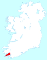
Beara Peninsula
Encyclopedia
Ireland
Ireland is an island to the northwest of continental Europe. It is the third-largest island in Europe and the twentieth-largest island on Earth...
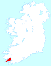
, bounded between the Kenmare
Kenmare
Kenmare is a small town in the south of County Kerry, Ireland. The name Kenmare is the anglicised form of Ceann Mara meaning "head of the sea", referring to the head of Kenmare Bay.-Location:...
"river" (actually a bay
Bay
A bay is an area of water mostly surrounded by land. Bays generally have calmer waters than the surrounding sea, due to the surrounding land blocking some waves and often reducing winds. Bays also exist as an inlet in a lake or pond. A large bay may be called a gulf, a sea, a sound, or a bight...
) to the north side and Bantry Bay to the south. It has two mountain ranges running down its centre: the Caha Mountains
Caha Mountains
The Caha Mountains are a range of low sandstone mountains situated on the Beara peninsula in south-west County Cork, in the Ireland. The highest peak is Hungry Hill, 685m tall.-See also:*List of mountains in Ireland...
and the Slieve Miskish Mountains
Slieve Miskish Mountains
The Slieve Miskish Mountains are a small range of low sandstone mountains found at the extreme south-western tip of the Beara Peninsula of County Cork in Ireland. Unlike the Caha Mountains, which lie further north on the peninsula, the Slieve Miskish Mountains lie entirely on the Cork side of the...
. The northern part of the peninsula from Kenmare to near Ardgroom is in County Kerry
County Kerry
Kerry means the "people of Ciar" which was the name of the pre-Gaelic tribe who lived in part of the present county. The legendary founder of the tribe was Ciar, son of Fergus mac Róich. In Old Irish "Ciar" meant black or dark brown, and the word continues in use in modern Irish as an adjective...
, while the rest forms the barony
Barony (Ireland)
In Ireland, a barony is a historical subdivision of a county. They were created, like the counties, in the centuries after the Norman invasion, and were analogous to the hundreds into which the counties of England were divided. In early use they were also called cantreds...
of Bear in County Cork
County Cork
County Cork is a county in Ireland. It is located in the South-West Region and is also part of the province of Munster. It is named after the city of Cork . Cork County Council is the local authority for the county...
.
Beara is a colloquial name for the area which, while geographically defined, actually straddles two county administrations and is not used officially by any civil administration or by An Post
An Post
An Post is the State-owned provider of postal services in the Republic of Ireland. An Post provides a universal postal service to all parts of the country as a member of the Universal Postal Union...
(the Irish Postal service).
History
Beara was the traditional seat of power of the O'Sullivan BeareO'Sullivan
O'Sullivan or simply Sullivan is an Irish surname, associated with the southwestern part of Ireland, originally found in County Tipperary before the Anglo-Norman invasion, then in County Cork and County Kerry, which due to emigration is also common in Australia, North America and Britain...
and was one of the last points of native Irish resistance after the Battle of Kinsale. Allihies
Allihies
Allihies is a coastal parish in the west of County Cork, Ireland. The largest village in the parish is Cluin, but is often mistakenly referred to by the name of the surrounding parish...
, on the tip of Beara, later became major copper mines and featured in the Daphne du Maurier
Daphne du Maurier
Dame Daphne du Maurier, Lady Browning DBE was a British author and playwright.Many of her works have been adapted into films, including the novels Rebecca and Jamaica Inn and the short stories "The Birds" and "Don't Look Now". The first three were directed by Alfred Hitchcock.Her elder sister was...
novel 'Hungry Hill
Hungry Hill (novel)
Hungry Hill is a novel by prolific British author Daphne du Maurier, published in 1943. There have been 33 editions of the book printed.This family saga is based on the Irish ancestors of Daphne du Maurier’s friend Christopher Puxley...
' also made into a film.
A plaque placed by the Beara historical Society offers the following to explain the origin of the name:
- In the early centuries AD, Conn Céad Cathach (Con of the hundred battles) fought a fierce battle against Owen Mór, King of Ireland at Cloch Barraige. Owen was badly injured in the battle. Those of his followers who survived took him to Inis Greaghraighe (now known as Bere Island) as a safe place for him to recover. There, the fairy Eadaoin took him to her grianán (bower) where she nursed him back to full health. Nowadays, this place is known as Greenane.
- Owen and his followers then sailed southwards until they reached Spain. There he met and married Beara, daughter of the King of Castille.
- Later Owen, Beara and a large army sailed from Spain and landed in Greenane. Owen took his wife to the highest hill on the island and looking across the harbour he named the island and the whole peninsula 'Beara' in honour of his wife. Rossmacowen, Kilmacowen and Buaile Owen most likely are named after Owen Mór and his son. According to local tradition Owen’s wife, Princess Beara, died and was buried in Ballard Commons in the remote and peaceful valley between Maulin and Knocknagree Mountains.
Tourist attractions
Dunboy Castle
Dunboy Castle was a stronghold of the O'Sullivan Bere, a Gaelic clan leader and 'Chief of Dunboy'. The castle is located on the Beara Peninsula in south-west Ireland near the town of Castletownbere and was built to guard and defend the harbour of Berehaven...
, Puxley Mansion, The Copper Mines Museum in Allihies
Allihies
Allihies is a coastal parish in the west of County Cork, Ireland. The largest village in the parish is Cluin, but is often mistakenly referred to by the name of the surrounding parish...
, Illnacullen Island in Glengarriff
Glengarriff
Glengarriff is a village of approximately 800 people on the N71 national secondary road in the south-west region of County Cork, Ireland. Known internationally as a tourism venue, it boasts many natural attractions...
(maintained by the OPW
Office of Public Works
The Office of Public Works is a State Agency of the Department of Finance in the Republic of Ireland...
) and Derreen Gardens (privately owned but open to the public).
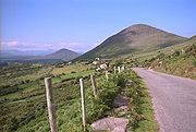
Many people come just to enjoy the wild and untamed nature of the place and the magical coastline.
The "Ring of Beara" is a tourist trail for cars which follows the roads for about 195 kilometres (121.2 mi) circumnavigating the peninsula. It starts in Kenmare
Kenmare
Kenmare is a small town in the south of County Kerry, Ireland. The name Kenmare is the anglicised form of Ceann Mara meaning "head of the sea", referring to the head of Kenmare Bay.-Location:...
, crossing the Healy Pass through Adrigole
Adrigole
Adrigole, is a village situated on the Beara Peninsula in County Cork, in Ireland. It is centred around the junction of the R572 and R574 regional roads. It has a sparsely distributed population of about 450 people....
, passing Castletownbere
Castletownbere
Castletownbere is a small town in County Cork in Ireland. It is located on the southwest coast of Ireland, in West Cork, on Berehaven harbour near the entrance to Bantry Bay. It is also known as Castletown Berehaven. The name of the town comes from the no longer extant MacCarty Castle, and not...
, Allihies
Allihies
Allihies is a coastal parish in the west of County Cork, Ireland. The largest village in the parish is Cluin, but is often mistakenly referred to by the name of the surrounding parish...
, and turn offs to Dursey Island
Dursey Island
Dursey Island lies at the southwestern tip of the Beara Peninsula in the west of County Cork in Ireland. Dursey Island is 6.5 km long and 1.5 km wide. The island is separated from the mainland by a narrow stretch of water called Dursey Sound which has a very strong tidal race, with a...
, Eyeries
Eyeries
Eyeries is a village and townland on the Beara Peninsula in County Cork, Ireland overlooking Coulagh Bay and the mouth of the Kenmare River in the south-west. It lies at the base of Maulin, which, at , is the highest peak in the Slieve Miskish mountain range that forms part of the backbone of the...
and Ardgroom
Ardgroom
Ardgroom is a village on the Beara peninsula in County Cork, Ireland. Its name refers to two gravelly hills deposited by a glacier, Dromárd and Drombeg. It lies to the northwest of Glenbeg Lough, overlooking the Kenmare River estuary. It sits between the coast and the Slieve Miskish Mountains. The...
, ending in Glengarriff
Glengarriff
Glengarriff is a village of approximately 800 people on the N71 national secondary road in the south-west region of County Cork, Ireland. Known internationally as a tourism venue, it boasts many natural attractions...
. The area has had a long connection with the sea; Castletownbere
Castletownbere
Castletownbere is a small town in County Cork in Ireland. It is located on the southwest coast of Ireland, in West Cork, on Berehaven harbour near the entrance to Bantry Bay. It is also known as Castletown Berehaven. The name of the town comes from the no longer extant MacCarty Castle, and not...
is one of Ireland's largest fishing ports and has diving, sailing and boating facilities.