
Otago
Encyclopedia
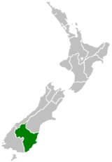
Otago is a region of New Zealand
in the south of the South Island
. The region covers an area of approximately 32000 square kilometres (12,355.3 sq mi) making it the country's second largest region. The population of Otago is
The name "Otago" is an old southern Maori word whose North Island dialect equivalent is "Otakou", introduced to the south by Europeans in the 1840s. The exact meaning of the term is disputed, with common translations being "isolated village" and "place of red earth", the latter referring to the reddish-ochre clay which is common in the area around Dunedin. "Otago" is also the old name of the European settlement on the Otago Harbour
, established by the Weller Brothers
in 1831. The place later became the focus of the Otago Association, an offshoot of the Free Church of Scotland, notable for its high-minded adoption of the principle that ordinary people, not the landowner, should choose the ministers.
Major centres of what is now the Otago Region of the old province include Dunedin (the principal city of the region), Oamaru
(made famous by Janet Frame
), Balclutha
, Alexandra
, and the major tourist centres Queenstown
and Wanaka
. Kaitangata
in South Otago
is a prominent source of coal
. The Waitaki
and Clutha
rivers also provide much of the country's hydroelectric
power. Some parts of the area originally covered by Otago Province are now administered as part of Southland Region.
New Zealand's first university, The University of Otago
, was founded in 1869 as the provincial university in Dunedin
.
The Central Otago wine area produces award winning wines made from varieties such as the Pinot Noir
, Chardonnay
, Sauvignon Blanc
, Merlot
, and Riesling
grapes. Central Otago has an increasing reputation as New Zealand’s leading pinot noir region.
The region is administered by the Otago Regional Council
.
, materialised in March 1848 with the arrival of the first two immigrant ships from Greenock
on the Firth of Clyde
-- the John Wickliffe
and the Philip Laing. Captain William Cargill
, a veteran of the Peninsular War
, was the secular leader: Otago citizens subsequently elected him to the office of provincial Superintendent after the provinces were created in 1852. The Otago Province was the whole of New Zealand from the Waitaki river south, including Stewart Island and the sub-Antarctic islands. It included the territory of the later Southland province and also the much more extensive lands of the modern Southland Region.
Initial settlement was concentrated on the port and city, then expanded, notably to the south-west, where the fertile Taieri Plains
offered good farmland.
The 1860s saw rapid commercial expansion after Gabriel Read
discovered gold at Gabriel's Gully
near Lawrence
, and the Central Otago goldrush ensued. Veterans of goldfields in California and Australia, plus many other fortune-seekers from Europe, North America and China, poured into the then Province
of Otago, eroding its Scottish Presbyterian character. Further gold discoveries at Clyde
and on the Arrow River round Arrowtown
led to a boom, and Otago became for a period the cultural and economic centre of New Zealand. New Zealand's first daily newspaper
, the Otago Daily Times
, originally edited by Julius Vogel
, dates from this period.
The Province
of Southland
separated from Otago Province
and set up its own Provincial Council at Invercargill
in 1861. After difficulties ensued, Otago re-absorbed it in 1870. Its territory is included in the southern region of the old Otago Province which is named after it and is now the territory of the Southland region
.
The provincial governments were abolished in 1876 when the Abolition of the Provinces Act came into force on 1 Nov 1876, and were replaced by other forms of local authority, including counties. Two in Otago were named after the Scottish independence heroes Wallace
and Bruce
. From this time the national limelight gradually shifted northwards.
 Beginning in the west, the geography of Otago consists of high alpine mountains. The highest peak in Otago is Mount Aspiring/Tititea, which is on the Main Divide. From the high mountains the rivers discharge into large glacial lakes. In this part of Otago glacial activity - both recent and very old - dominates the landscape, with large 'U' shaped valleys and rivers which have high sediment loads. River flows also vary dramatically, with large flood flows occurring after heavy rain. Lakes Wakatipu, Wanaka and Hawea form the sources of the Clutha, the largest river (by discharge) in New Zealand. The Clutha flows through Otago and discharges near Balclutha
.
Travelling east from the mountains, the Central Otago drylands predominate. These are Canterbury-Otago tussock grasslands
dominated by the block mountains, upthrust schist
mountains. In contrast to Canterbury, where the Northwest winds blow across the plains without interruption, in Otago the block mountains impede and dilute the effects of the Nor'wester
.
The main Central Otago centres, such as Alexandra
and Cromwell
, are found in the intermontane basins between the block mountains. The schist bedrock influence extends to the eastern part of Otago, where remnant volcanics mark its edge. The remains of the most spectacular of these are the Miocene volcanics centred on Otago Harbour
. Elsewhere, basalt outcrops can be found along the coast and at other sites.
In the southeastern corner of Otago lies The Catlins
, an area of rough hill country which geologically forms part of the Murihiku terrane
, an accretion which extends inland through the Hokonui Hills
in the Southland Region
. This itself forms part of a larger system known as the Southland Syncline
, which links to similar formations in Nelson
(offset by the Alpine Fault
) and even in New Caledonia
, 3500 km (2,174.8 mi) away. The Catlins ranges are strike ridges composed of Triassic
and Jurassic
sandstone
s, mudstone
s and other related sedimentary rocks, often with a high incidence of feldspar
. Fossils of the late and middle Triassic Warepan and Kaihikuan
stages are found in the area.
Coastal regions of Otago are subject to the alternating warm and dry/cool and wet weather patterns common to the interannual Southern oscillation. The Southern Hemisphere storm track produces an irregular short cycle of weather which repeats roughly every week, with three or four days of fine weather followed by three or four days of cooler, damp conditions. Drier conditions are often the result of the northwesterly
föhn wind, which dries as it crosses the Southern Alps
. Wetter air is the result of approaching low-pressure systems which sweep fronts over the country from the southwest. A common variant in this pattern is the centring of a stationary low-pressure zone to the southeast of the country, resulting in long-lasting cool, wet conditions. These have been responsible for several notable historical floods, such as the "hundred year floods" of October 1878 and October 1978.
Typically, winters are cool and wet. Snow can fall and settle to sea level in winter, especially in the hills and plains of South Otago
. Summers, by contrast, tend to be warm and dry, with temperatures often reaching the mid to high 20s Celsius.
In Central Otago
cold frosty winters are succeeded by hot dry summers. Central Otago's climate is the closest approximation to a continental climate anywhere in New Zealand. This climate is part of the reason why Central Otago vineyards are successful growing is this region. This inland region is one of the driest regions in the country, sheltered from prevailing rain-bearing weather conditions by the high mountains to the west and hills of the south. Summers can be hot, with temperatures often approaching or exceeding 30 degrees Celsius; winters, by contrast, are often bitterly cold - the township of Ophir
in Central Otago holds the New Zealand record for lowest temperature with a reading of -21.6 °C on 3 July 1995.
especially its medical school
which attracts students from all over New Zealand and overseas.
Other significant urban centres in Otago with populations over 1,000 include: Queenstown
, Oamaru
, Wanaka
, Cromwell
, Alexandra
, Balclutha
, Milton
and Mosgiel
. Between 1996 and 2006, the population of the Queenstown Lakes District grew by 60% due to the region’s booming tourism
industry.
Approximately 80% of the region’s population is of European lineage with the majority being of Scottish
stock—the descendants of early Scottish settlers from the early 19th century. Maori comprise approximately 7% of the population with a large proportion being from the Ngāi Tahu
iwi
or tribe. Other significant ethnic minorities include Asians, Pacific Islanders, Africans, Latin Americans and Middle Easterners.
s with the city of Dunedin
comprising two of these. The Dunedin North
electorate is held by Pete Hodgson
while the Dunedin South
electorate is occupied by Clare Curran
. Both MPs are members of the opposition Labour Party
while Dunedin has traditionally been a Labour stronghold.
Since 2008, the former electorate of Otago has been split and merged into the large rural electorates of Waitaki
which also includes some of the neighbouring Canterbury
Region, and the Clutha-Southland electorate, which also includes most of the rural part of the neighbouring Southland Region. The Waitaki electorate has traditionally been a National Party
stronghold and is currently held by Jacqui Dean
. The Clutha-Southland electorate, also a National Party stronghold, is currently held by Deputy Prime Minister
Bill English
.
Under the Māori seats
system, Otago is also part of the large Te Tai Tonga electorate, which covers the entire South Island and surrounding islands. This is currently held by Māori Party
MP Rahui Katene
.
. There are five territorial authorities
in the Otago region:
Regions of New Zealand
The region is the top tier of local government in New Zealand. There are 16 regions of New Zealand. Eleven are governed by an elected regional council, while five are governed by territorial authorities which also perform the functions of a regional council and thus are known as unitary authorities...
in the south of the South Island
South Island
The South Island is the larger of the two major islands of New Zealand, the other being the more populous North Island. It is bordered to the north by Cook Strait, to the west by the Tasman Sea, to the south and east by the Pacific Ocean...
. The region covers an area of approximately 32000 square kilometres (12,355.3 sq mi) making it the country's second largest region. The population of Otago is
The name "Otago" is an old southern Maori word whose North Island dialect equivalent is "Otakou", introduced to the south by Europeans in the 1840s. The exact meaning of the term is disputed, with common translations being "isolated village" and "place of red earth", the latter referring to the reddish-ochre clay which is common in the area around Dunedin. "Otago" is also the old name of the European settlement on the Otago Harbour
Otago Harbour
Otago Harbour is the natural harbour of Dunedin, New Zealand, consisting of a long, much-indented stretch of generally navigable water separating the Otago Peninsula from the mainland. They join at its southwest end, from the harbour mouth...
, established by the Weller Brothers
Weller brothers
The Weller brothers, Englishmen of Sydney and Otago, New Zealand, were the founders of a whaling station on Otago Harbour and New Zealand’s most substantial merchant traders in the 1830s.-Immigration:...
in 1831. The place later became the focus of the Otago Association, an offshoot of the Free Church of Scotland, notable for its high-minded adoption of the principle that ordinary people, not the landowner, should choose the ministers.
Major centres of what is now the Otago Region of the old province include Dunedin (the principal city of the region), Oamaru
Oamaru
Oamaru , the largest town in North Otago, in the South Island of New Zealand, is the main town in the Waitaki District. It is 80 kilometres south of Timaru and 120 kilometres north of Dunedin, on the Pacific coast, and State Highway 1 and the railway Main South Line connects it to both...
(made famous by Janet Frame
Janet Frame
Janet Paterson Frame, ONZ, CBE was a New Zealand author. She wrote eleven novels, four collections of short stories, a book of poetry, an edition of juvenile fiction, and three volumes of autobiography during her lifetime. Since her death, a twelfth novel, a second volume of poetry, and a handful...
), Balclutha
Balclutha, New Zealand
Balclutha is a town in Otago, it lies towards the end of the Clutha River on the east coast of the South Island of New Zealand. It is about halfway between Dunedin and Invercargill on the Main South Line railway, State Highway 1 and the Southern Scenic Route...
, Alexandra
Alexandra, New Zealand
Alexandra is a town in the Central Otago district of the Otago region of New Zealand. It is located on the banks of the Clutha River , on State Highway 8, 188 km by road from Dunedin and 33 km south of Cromwell.At the time of the 2006 census, the permanent population was 4,827, an...
, and the major tourist centres Queenstown
Queenstown, New Zealand
Queenstown is a resort town in Otago in the south-west of New Zealand's South Island. It is built around an inlet called Queenstown Bay on Lake Wakatipu, a long thin Z-shaped lake formed by glacial processes, and has spectacular views of nearby mountains....
and Wanaka
Wanaka
Wanaka is a town in the Otago region of the South Island of New Zealand. It is situated at the southern end of Lake Wanaka, adjacent to the outflow of the lake to the Clutha River. It is the gateway to Mount Aspiring National Park. Wanaka is primarily a resort town but has both summer and winter...
. Kaitangata
Kaitangata, New Zealand
Kaitangata is a town near the coast of South Otago, New Zealand, on the left bank of the Clutha River ten kilometres south east of Balclutha. The town is known to its residents simply as Kai....
in South Otago
South Otago
South Otago lies in the south east of the South Island of New Zealand. As the name suggests, it forms the southernmost part of the geographical region of Otago....
is a prominent source of coal
Coal
Coal is a combustible black or brownish-black sedimentary rock usually occurring in rock strata in layers or veins called coal beds or coal seams. The harder forms, such as anthracite coal, can be regarded as metamorphic rock because of later exposure to elevated temperature and pressure...
. The Waitaki
Waitaki River
The Waitaki River is a large river in the South Island of New Zealand, some 110 km long. It is the major river of the Mackenzie Basin.It is a braided river which flows through Lake Benmore, Lake Aviemore and Lake Waitaki. These are ultimately fed by three large glacial lakes, Pukaki, Tekapo,...
and Clutha
Clutha River
The Clutha River / Mata-Au is the second longest river in New Zealand flowing south-southeast through Central and South Otago from Lake Wanaka in the Southern Alps to the Pacific Ocean, south west of Dunedin. It is the highest volume river in New Zealand, and the swiftest, with a catchment of ,...
rivers also provide much of the country's hydroelectric
Hydroelectricity
Hydroelectricity is the term referring to electricity generated by hydropower; the production of electrical power through the use of the gravitational force of falling or flowing water. It is the most widely used form of renewable energy...
power. Some parts of the area originally covered by Otago Province are now administered as part of Southland Region.
New Zealand's first university, The University of Otago
University of Otago
The University of Otago in Dunedin is New Zealand's oldest university with over 22,000 students enrolled during 2010.The university has New Zealand's highest average research quality and in New Zealand is second only to the University of Auckland in the number of A rated academic researchers it...
, was founded in 1869 as the provincial university in Dunedin
Dunedin
Dunedin is the second-largest city in the South Island of New Zealand, and the principal city of the Otago Region. It is considered to be one of the four main urban centres of New Zealand for historic, cultural, and geographic reasons. Dunedin was the largest city by territorial land area until...
.
The Central Otago wine area produces award winning wines made from varieties such as the Pinot Noir
Pinot Noir
Pinot noir is a black wine grape variety of the species Vitis vinifera. The name may also refer to wines created predominantly from Pinot noir grapes...
, Chardonnay
Chardonnay
Chardonnay is a green-skinned grape variety used to make white wine. It is originated from the Burgundy wine region of eastern France but is now grown wherever wine is produced, from England to New Zealand...
, Sauvignon Blanc
Sauvignon blanc
Sauvignon Blanc is a green-skinned grape variety which originates from the Bordeaux region of France. The grape most likely gets its name from the French word sauvage and blanc due to its early origins as an indigenous grape in South West France., a possible descendant of savagnin...
, Merlot
Merlot
Merlot is a darkly blue-coloured wine grape, that is used as both a blending grape and for varietal wines. The name Merlot is thought to derive from the Old French word for young blackbird, merlot, a diminutive of merle, the blackbird , probably from the color of the grape. Merlot-based wines...
, and Riesling
Riesling
Riesling is a white grape variety which originated in the Rhine region of Germany. Riesling is an aromatic grape variety displaying flowery, almost perfumed, aromas as well as high acidity. It is used to make dry, semi-sweet, sweet and sparkling white wines. Riesling wines are usually varietally...
grapes. Central Otago has an increasing reputation as New Zealand’s leading pinot noir region.
The region is administered by the Otago Regional Council
Otago Regional Council
Otago Regional Council is the regional council for the Otago region in the South Island of New Zealand. The council's principal office is Regional House on Stafford Street in Dunedin, with smaller offices in Queenstown and Alexandra....
.
History
The Otago settlement, an outgrowth of the Free Church of ScotlandFree Church of Scotland (1843-1900)
The Free Church of Scotland is a Scottish denomination which was formed in 1843 by a large withdrawal from the established Church of Scotland in a schism known as the "Disruption of 1843"...
, materialised in March 1848 with the arrival of the first two immigrant ships from Greenock
Greenock
Greenock is a town and administrative centre in the Inverclyde council area in United Kingdom, and a former burgh within the historic county of Renfrewshire, located in the west central Lowlands of Scotland...
on the Firth of Clyde
Firth of Clyde
The Firth of Clyde forms a large area of coastal water, sheltered from the Atlantic Ocean by the Kintyre peninsula which encloses the outer firth in Argyll and Ayrshire, Scotland. The Kilbrannan Sound is a large arm of the Firth of Clyde, separating the Kintyre Peninsula from the Isle of Arran.At...
-- the John Wickliffe
John Wickliffe (ship)
John Wickliffe was the first ship to arrive carrying Scottish settlers, including Otago settlement founder Captain William Cargill, in the city of Dunedin, New Zealand...
and the Philip Laing. Captain William Cargill
William Cargill
William Walter Cargill was the founder of the Otago settlement in New Zealand, after serving as an officer in the British Army. He was a Member of Parliament and Otago's first Superintendent.-Early life:...
, a veteran of the Peninsular War
Peninsular War
The Peninsular War was a war between France and the allied powers of Spain, the United Kingdom, and Portugal for control of the Iberian Peninsula during the Napoleonic Wars. The war began when French and Spanish armies crossed Spain and invaded Portugal in 1807. Then, in 1808, France turned on its...
, was the secular leader: Otago citizens subsequently elected him to the office of provincial Superintendent after the provinces were created in 1852. The Otago Province was the whole of New Zealand from the Waitaki river south, including Stewart Island and the sub-Antarctic islands. It included the territory of the later Southland province and also the much more extensive lands of the modern Southland Region.
Initial settlement was concentrated on the port and city, then expanded, notably to the south-west, where the fertile Taieri Plains
Taieri Plains
The Taieri Plains are an area of fertile agricultural land to the southwest of Dunedin, in Otago, New Zealand. The plains cover an area of some 300 square kilometres, with a maximum extent of 30 kilometres....
offered good farmland.
The 1860s saw rapid commercial expansion after Gabriel Read
Gabriel Read
Gabriel Read was an Australian gold prospector who, after working on the goldfields of California and Victoria, Australia travelled to New Zealand, having heard rumours of gold being found in Mataura, Southland. On 20 May 1861, he discovered gold close to the banks of the Tuapeka River in Otago,...
discovered gold at Gabriel's Gully
Gabriel's Gully
Gabriel's Gully is a locality in Otago, New Zealand, three kilometres from Lawrence township and close to the Tuapeka River.The discovery of gold at Gabriel's Gully by Gabriel Read in May 1861 led to the Central Otago goldrush...
near Lawrence
Lawrence, New Zealand
Lawrence is a small town of 474 inhabitants in Otago, in New Zealand's South Island. It is located on State Highway 8, the main route from Dunedin to the inland towns of Queenstown and Alexandra...
, and the Central Otago goldrush ensued. Veterans of goldfields in California and Australia, plus many other fortune-seekers from Europe, North America and China, poured into the then Province
Provinces of New Zealand
The Provinces of New Zealand existed from 1841 until 1876 as a form of sub-national government. They were replaced by counties, which were themselves replaced by districts.Following abolition, the provinces became known as provincial districts...
of Otago, eroding its Scottish Presbyterian character. Further gold discoveries at Clyde
Clyde, New Zealand
Clyde is a small town in Central Otago, New Zealand with a population of 918 in 2006. It is located on the Clutha River, between Cromwell and Alexandra....
and on the Arrow River round Arrowtown
Arrowtown
Arrowtown is a historic gold mining town in the Otago region of the South Island of New Zealand. Arrowtown is located on the banks of the Arrow River approximately 5 km from State Highway 6...
led to a boom, and Otago became for a period the cultural and economic centre of New Zealand. New Zealand's first daily newspaper
Newspaper
A newspaper is a scheduled publication containing news of current events, informative articles, diverse features and advertising. It usually is printed on relatively inexpensive, low-grade paper such as newsprint. By 2007, there were 6580 daily newspapers in the world selling 395 million copies a...
, the Otago Daily Times
Otago Daily Times
The Otago Daily Times is a newspaper published by Allied Press Ltd in Dunedin, New Zealand.-History:Originally styled The Otago Daily Times, the ODT was first published on November 15, 1861. It is New Zealand's oldest surviving daily newspaper - Christchurch's The Press, six months older, was a...
, originally edited by Julius Vogel
Julius Vogel
Sir Julius Vogel, KCMG was the eighth Premier of New Zealand. His administration is best remembered for the issuing of bonds to fund railway construction and other public works...
, dates from this period.
The Province
Provinces of New Zealand
The Provinces of New Zealand existed from 1841 until 1876 as a form of sub-national government. They were replaced by counties, which were themselves replaced by districts.Following abolition, the provinces became known as provincial districts...
of Southland
Southland Province
The Southland Province was a province of New Zealand from March 1861 until the province rejoined with Otago Province in 1870.-History:When provinces were formed in 1853, the southern part of New Zealand belonged to Otago Province...
separated from Otago Province
Otago Province
The Otago Province was a province of New Zealand until the abolition of provincial government in 1876.-Area:The capital of the province was Dunedin...
and set up its own Provincial Council at Invercargill
Invercargill
Invercargill is the southernmost and westernmost city in New Zealand, and one of the southernmost cities in the world. It is the commercial centre of the Southland region. It lies in the heart of the wide expanse of the Southland Plains on the Oreti or New River some 18 km north of Bluff,...
in 1861. After difficulties ensued, Otago re-absorbed it in 1870. Its territory is included in the southern region of the old Otago Province which is named after it and is now the territory of the Southland region
Regions of New Zealand
The region is the top tier of local government in New Zealand. There are 16 regions of New Zealand. Eleven are governed by an elected regional council, while five are governed by territorial authorities which also perform the functions of a regional council and thus are known as unitary authorities...
.
The provincial governments were abolished in 1876 when the Abolition of the Provinces Act came into force on 1 Nov 1876, and were replaced by other forms of local authority, including counties. Two in Otago were named after the Scottish independence heroes Wallace
William Wallace
Sir William Wallace was a Scottish knight and landowner who became one of the main leaders during the Wars of Scottish Independence....
and Bruce
Robert I of Scotland
Robert I , popularly known as Robert the Bruce , was King of Scots from March 25, 1306, until his death in 1329.His paternal ancestors were of Scoto-Norman heritage , and...
. From this time the national limelight gradually shifted northwards.
Economy
The sub-national GDP of the Otago region was estimated at US$5.411 billion in 2003, 4% of New Zealand's national GDP.Geography
Balclutha, New Zealand
Balclutha is a town in Otago, it lies towards the end of the Clutha River on the east coast of the South Island of New Zealand. It is about halfway between Dunedin and Invercargill on the Main South Line railway, State Highway 1 and the Southern Scenic Route...
.
Travelling east from the mountains, the Central Otago drylands predominate. These are Canterbury-Otago tussock grasslands
Canterbury-Otago tussock grasslands
The Canterbury-Otago tussock grasslands are an ecoregion of South Island, New Zealand.-Location and description:This ecoregion is a large area of dry grassy plains between the east coast and the Southern Alps that form the spine of South Island, in the regions of Canterbury and Otago...
dominated by the block mountains, upthrust schist
Schist
The schists constitute a group of medium-grade metamorphic rocks, chiefly notable for the preponderance of lamellar minerals such as micas, chlorite, talc, hornblende, graphite, and others. Quartz often occurs in drawn-out grains to such an extent that a particular form called quartz schist is...
mountains. In contrast to Canterbury, where the Northwest winds blow across the plains without interruption, in Otago the block mountains impede and dilute the effects of the Nor'wester
Nor'west arch
The Nor'west arch is a weather pattern peculiar to the east coast of New Zealand's South Island. For this reason, it is also often referred to as the Canterbury arch. It is shown in an apparent arch of high white cloud in an otherwise clear blue sky over the Southern Alps, and is accompanied by a...
.
The main Central Otago centres, such as Alexandra
Alexandra, New Zealand
Alexandra is a town in the Central Otago district of the Otago region of New Zealand. It is located on the banks of the Clutha River , on State Highway 8, 188 km by road from Dunedin and 33 km south of Cromwell.At the time of the 2006 census, the permanent population was 4,827, an...
and Cromwell
Cromwell, New Zealand
Cromwell is a town in Central Otago in the Otago region of New Zealand.It is situated between State Highway 6 and State Highway 8 leading to the Lindis Pass, 75 km northeast, and Alexandra, 33 km south. The road to Alexandra winds through the Cromwell Gorge...
, are found in the intermontane basins between the block mountains. The schist bedrock influence extends to the eastern part of Otago, where remnant volcanics mark its edge. The remains of the most spectacular of these are the Miocene volcanics centred on Otago Harbour
Otago Harbour
Otago Harbour is the natural harbour of Dunedin, New Zealand, consisting of a long, much-indented stretch of generally navigable water separating the Otago Peninsula from the mainland. They join at its southwest end, from the harbour mouth...
. Elsewhere, basalt outcrops can be found along the coast and at other sites.
In the southeastern corner of Otago lies The Catlins
The Catlins
The Catlins comprises an area in the southeastern corner of the South Island of New Zealand. The area lies between Balclutha and Invercargill, straddling the boundary between the Otago and Southland regions...
, an area of rough hill country which geologically forms part of the Murihiku terrane
Terrane
A terrane in geology is short-hand term for a tectonostratigraphic terrane, which is a fragment of crustal material formed on, or broken off from, one tectonic plate and accreted or "sutured" to crust lying on another plate...
, an accretion which extends inland through the Hokonui Hills
Hokonui Hills
The Hokonui Hills, also known as The Hokonui Mountains or simply The Hokonui, are a range of hills in northern Southland, New Zealand. They rise to 600 metres above the surrounding Southland Plains, of which the hills mark a northern extremity....
in the Southland Region
Southland Region
Southland is New Zealand's southernmost region and is also a district within that region. It consists mainly of the southwestern portion of the South Island and Stewart Island / Rakiura...
. This itself forms part of a larger system known as the Southland Syncline
Syncline
In structural geology, a syncline is a fold, with younger layers closer to the center of the structure. A synclinorium is a large syncline with superimposed smaller folds. Synclines are typically a downward fold, termed a synformal syncline In structural geology, a syncline is a fold, with younger...
, which links to similar formations in Nelson
Nelson, New Zealand
Nelson is a city on the eastern shores of Tasman Bay, and is the economic and cultural centre of the Nelson-Tasman region. Established in 1841, it is the second oldest settled city in New Zealand and the oldest in the South Island....
(offset by the Alpine Fault
Alpine Fault
The Alpine Fault is a geological fault, more specifically known as a right-lateral strike-slip fault, that runs almost the entire length of New Zealand's South Island. It forms a transform boundary between the Pacific Plate and the Indo-Australian Plate. Earthquakes along the fault, and the...
) and even in New Caledonia
New Caledonia
New Caledonia is a special collectivity of France located in the southwest Pacific Ocean, east of Australia and about from Metropolitan France. The archipelago, part of the Melanesia subregion, includes the main island of Grande Terre, the Loyalty Islands, the Belep archipelago, the Isle of...
, 3500 km (2,174.8 mi) away. The Catlins ranges are strike ridges composed of Triassic
Triassic
The Triassic is a geologic period and system that extends from about 250 to 200 Mya . As the first period of the Mesozoic Era, the Triassic follows the Permian and is followed by the Jurassic. Both the start and end of the Triassic are marked by major extinction events...
and Jurassic
Jurassic
The Jurassic is a geologic period and system that extends from about Mya to Mya, that is, from the end of the Triassic to the beginning of the Cretaceous. The Jurassic constitutes the middle period of the Mesozoic era, also known as the age of reptiles. The start of the period is marked by...
sandstone
Sandstone
Sandstone is a sedimentary rock composed mainly of sand-sized minerals or rock grains.Most sandstone is composed of quartz and/or feldspar because these are the most common minerals in the Earth's crust. Like sand, sandstone may be any colour, but the most common colours are tan, brown, yellow,...
s, mudstone
Mudstone
Mudstone is a fine grained sedimentary rock whose original constituents were clays or muds. Grain size is up to 0.0625 mm with individual grains too small to be distinguished without a microscope. With increased pressure over time the platey clay minerals may become aligned, with the...
s and other related sedimentary rocks, often with a high incidence of feldspar
Feldspar
Feldspars are a group of rock-forming tectosilicate minerals which make up as much as 60% of the Earth's crust....
. Fossils of the late and middle Triassic Warepan and Kaihikuan
New Zealand geologic time scale
While also using the international Geologic time scale, many nations - especially those with isolated and therefore non-standard prehistories - use their own system of dividing geologic time into epochs and faunal stages....
stages are found in the area.
Climate
Weather conditions vary enormously across Otago, but can be broken into two broad types: the coastal climate of the coastal regions and the more continental climate of the interior.Coastal regions of Otago are subject to the alternating warm and dry/cool and wet weather patterns common to the interannual Southern oscillation. The Southern Hemisphere storm track produces an irregular short cycle of weather which repeats roughly every week, with three or four days of fine weather followed by three or four days of cooler, damp conditions. Drier conditions are often the result of the northwesterly
Nor'west arch
The Nor'west arch is a weather pattern peculiar to the east coast of New Zealand's South Island. For this reason, it is also often referred to as the Canterbury arch. It is shown in an apparent arch of high white cloud in an otherwise clear blue sky over the Southern Alps, and is accompanied by a...
föhn wind, which dries as it crosses the Southern Alps
Southern Alps
The Southern Alps is a mountain range extending along much of the length of New Zealand's South Island, reaching its greatest elevations near the island's western side...
. Wetter air is the result of approaching low-pressure systems which sweep fronts over the country from the southwest. A common variant in this pattern is the centring of a stationary low-pressure zone to the southeast of the country, resulting in long-lasting cool, wet conditions. These have been responsible for several notable historical floods, such as the "hundred year floods" of October 1878 and October 1978.
Typically, winters are cool and wet. Snow can fall and settle to sea level in winter, especially in the hills and plains of South Otago
South Otago
South Otago lies in the south east of the South Island of New Zealand. As the name suggests, it forms the southernmost part of the geographical region of Otago....
. Summers, by contrast, tend to be warm and dry, with temperatures often reaching the mid to high 20s Celsius.
In Central Otago
Central Otago
Central Otago is the inland part of the New Zealand region of Otago in the South Island. The area commonly known as Central Otago includes both the Central Otago District and the Queenstown-Lakes District to the west....
cold frosty winters are succeeded by hot dry summers. Central Otago's climate is the closest approximation to a continental climate anywhere in New Zealand. This climate is part of the reason why Central Otago vineyards are successful growing is this region. This inland region is one of the driest regions in the country, sheltered from prevailing rain-bearing weather conditions by the high mountains to the west and hills of the south. Summers can be hot, with temperatures often approaching or exceeding 30 degrees Celsius; winters, by contrast, are often bitterly cold - the township of Ophir
Ophir, New Zealand
Omakau is a settlement in Central Otago, New Zealand, located between Alexandra and Ranfurly on the northwest bank of the Manuherikia River.The smaller settlement of Ophir, New Zealand is located on the opposite bank, three kilometres to the southeast....
in Central Otago holds the New Zealand record for lowest temperature with a reading of -21.6 °C on 3 July 1995.
Population
The population of Otago is , which is approximately percent of New Zealand’s total population of million. About percent of the population resides in the Dunedin urban area—the region’s main city and the country’s sixth largest urban area. For historical and geographical reasons, Dunedin is usually regarded as one of New Zealand's four main centres. Unlike other southern centres, Dunedin’s population has not declined since the 1970s due to the presence of the University of OtagoUniversity of Otago
The University of Otago in Dunedin is New Zealand's oldest university with over 22,000 students enrolled during 2010.The university has New Zealand's highest average research quality and in New Zealand is second only to the University of Auckland in the number of A rated academic researchers it...
especially its medical school
University of Otago Dunedin School of Medicine
The Dunedin School of Medicine is one of three medical schools that make up the Faculty of Medicine at the University of Otago. All Otago University medical students who gain entry after a first year "Health Sciences" program, or who gain graduate entry spend their second and third years studying...
which attracts students from all over New Zealand and overseas.
Other significant urban centres in Otago with populations over 1,000 include: Queenstown
Queenstown, New Zealand
Queenstown is a resort town in Otago in the south-west of New Zealand's South Island. It is built around an inlet called Queenstown Bay on Lake Wakatipu, a long thin Z-shaped lake formed by glacial processes, and has spectacular views of nearby mountains....
, Oamaru
Oamaru
Oamaru , the largest town in North Otago, in the South Island of New Zealand, is the main town in the Waitaki District. It is 80 kilometres south of Timaru and 120 kilometres north of Dunedin, on the Pacific coast, and State Highway 1 and the railway Main South Line connects it to both...
, Wanaka
Wanaka
Wanaka is a town in the Otago region of the South Island of New Zealand. It is situated at the southern end of Lake Wanaka, adjacent to the outflow of the lake to the Clutha River. It is the gateway to Mount Aspiring National Park. Wanaka is primarily a resort town but has both summer and winter...
, Cromwell
Cromwell, New Zealand
Cromwell is a town in Central Otago in the Otago region of New Zealand.It is situated between State Highway 6 and State Highway 8 leading to the Lindis Pass, 75 km northeast, and Alexandra, 33 km south. The road to Alexandra winds through the Cromwell Gorge...
, Alexandra
Alexandra, New Zealand
Alexandra is a town in the Central Otago district of the Otago region of New Zealand. It is located on the banks of the Clutha River , on State Highway 8, 188 km by road from Dunedin and 33 km south of Cromwell.At the time of the 2006 census, the permanent population was 4,827, an...
, Balclutha
Balclutha, New Zealand
Balclutha is a town in Otago, it lies towards the end of the Clutha River on the east coast of the South Island of New Zealand. It is about halfway between Dunedin and Invercargill on the Main South Line railway, State Highway 1 and the Southern Scenic Route...
, Milton
Milton, New Zealand
Milton is a town of 2,000 people, located on State Highway 1, 50 kilometres to the south of Dunedin in Otago, New Zealand. It lies on the floodplain of the Tokomairiro River, one branch of which loops past the north and south ends of the town...
and Mosgiel
Mosgiel
Mosgiel is an urban satellite of Dunedin in Otago, New Zealand, fifteen kilometres west of the city's centre. Since the re-organisation of New Zealand local government in 1989 it has been inside the Dunedin City Council area, but was physically separate from the contiguous suburbs until...
. Between 1996 and 2006, the population of the Queenstown Lakes District grew by 60% due to the region’s booming tourism
Tourism
Tourism is travel for recreational, leisure or business purposes. The World Tourism Organization defines tourists as people "traveling to and staying in places outside their usual environment for not more than one consecutive year for leisure, business and other purposes".Tourism has become a...
industry.
Approximately 80% of the region’s population is of European lineage with the majority being of Scottish
Scotland
Scotland is a country that is part of the United Kingdom. Occupying the northern third of the island of Great Britain, it shares a border with England to the south and is bounded by the North Sea to the east, the Atlantic Ocean to the north and west, and the North Channel and Irish Sea to the...
stock—the descendants of early Scottish settlers from the early 19th century. Maori comprise approximately 7% of the population with a large proportion being from the Ngāi Tahu
Ngāi Tahu
Ngāi Tahu, or Kāi Tahu, is the principal Māori iwi of the southern region of New Zealand, with the tribal authority, Te Rūnanga o Ngāi Tahu, being based in Christchurch and Invercargill. The iwi combines three groups, Kāi Tahu itself, and Waitaha and Kāti Mamoe who lived in the South Island prior...
iwi
Iwi
In New Zealand society, iwi form the largest everyday social units in Māori culture. The word iwi means "'peoples' or 'nations'. In "the work of European writers which treat iwi and hapū as parts of a hierarchical structure", it has been used to mean "tribe" , or confederation of tribes,...
or tribe. Other significant ethnic minorities include Asians, Pacific Islanders, Africans, Latin Americans and Middle Easterners.
Representation
Otago is divided into four parliamentary electorateElectoral district
An electoral district is a distinct territorial subdivision for holding a separate election for one or more seats in a legislative body...
s with the city of Dunedin
Dunedin
Dunedin is the second-largest city in the South Island of New Zealand, and the principal city of the Otago Region. It is considered to be one of the four main urban centres of New Zealand for historic, cultural, and geographic reasons. Dunedin was the largest city by territorial land area until...
comprising two of these. The Dunedin North
Dunedin North (New Zealand electorate)
Dunedin North is a New Zealand parliamentary electorate, returning one Member of Parliament to the New Zealand House of Representatives. It was established for the 1905 election and has existed since....
electorate is held by Pete Hodgson
Pete Hodgson
Peter Colin Hodgson is a New Zealand politician. He is a member of the Labour Party.Hodgson was born in Whangarei, and received a Bachelor's degree in veterinary science from Massey University...
while the Dunedin South
Dunedin South
Dunedin South is a New Zealand Parliamentary electorate. It first existed from 1881–1890, then from 1905–1946 and was re-established for the introduction of MMP in 1996. A Labour Party stronghold, it has been represented by Clare Curran since the .-Area:...
electorate is occupied by Clare Curran
Clare Curran
Clare Elizabeth Curran is the 3rd and current member of the New Zealand Parliament for Dunedin South.-Early life and education:Curran grew up and was educated in Dunedin, she attended Moreau College where she achieved School Certificate...
. Both MPs are members of the opposition Labour Party
New Zealand Labour Party
The New Zealand Labour Party is a New Zealand political party. It describes itself as centre-left and socially progressive and has been one of the two primary parties of New Zealand politics since 1935....
while Dunedin has traditionally been a Labour stronghold.
Since 2008, the former electorate of Otago has been split and merged into the large rural electorates of Waitaki
Waitaki (New Zealand electorate)
Waitaki is an electorate for the New Zealand House of Representatives that crosses the boundary of North Otago and South Canterbury towns on the East Coast of the South Island. The electorate was first established for the that determined the 5th New Zealand Parliament...
which also includes some of the neighbouring Canterbury
Canterbury, New Zealand
The New Zealand region of Canterbury is mainly composed of the Canterbury Plains and the surrounding mountains. Its main city, Christchurch, hosts the main office of the Christchurch City Council, the Canterbury Regional Council - called Environment Canterbury - and the University of Canterbury.-...
Region, and the Clutha-Southland electorate, which also includes most of the rural part of the neighbouring Southland Region. The Waitaki electorate has traditionally been a National Party
New Zealand National Party
The New Zealand National Party is the largest party in the New Zealand House of Representatives and in November 2008 formed a minority government with support from three minor parties.-Policies:...
stronghold and is currently held by Jacqui Dean
Jacqui Dean
Jacqueline Isobel Dean is a New Zealand politician and the current Member of Parliament for the Waitaki electorate.-Early career:Dean has worked in a number of roles, including professional acting...
. The Clutha-Southland electorate, also a National Party stronghold, is currently held by Deputy Prime Minister
Deputy Prime Minister of New Zealand
The Deputy Prime Minister of New Zealand is second most senior officer in the Government of New Zealand, although this seniority does not necessarily translate into power....
Bill English
Bill English
Simon William "Bill" English is the Deputy Prime Minister, Minister of Finance and Minister of Infrastructure of New Zealand.English entered parliament in 1990 as a National party MP representing the Wallace electorate...
.
Under the Māori seats
Maori seats
In New Zealand politics, Māori electorates, colloquially also called Māori seats, are a special category of electorate that gives reserved positions to representatives of Māori in the New Zealand Parliament...
system, Otago is also part of the large Te Tai Tonga electorate, which covers the entire South Island and surrounding islands. This is currently held by Māori Party
Maori Party
The Māori Party, a political party in New Zealand, was formed on 7 July 2004. The Party is guided by eight constitutional "kaupapa", or Party objectives. Tariana Turia formed the Māori Party after resigning from the Labour Party where she had been a Cabinet Minister in the Fifth Labour-led...
MP Rahui Katene
Rahui Katene
Rahui Katene is a New Zealand politician. She was elected to the 49th New Zealand Parliament at the 2008 general election representing the Māori Party in the seat of Te Tai Tonga, but lost in the 2011 general election to Labour's Rino Tirikatene.- Ancestry :...
.
Administration
The seat of the Otago Regional Council is in DunedinDunedin
Dunedin is the second-largest city in the South Island of New Zealand, and the principal city of the Otago Region. It is considered to be one of the four main urban centres of New Zealand for historic, cultural, and geographic reasons. Dunedin was the largest city by territorial land area until...
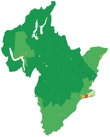
. There are five territorial authorities
Territorial authorities of New Zealand
Territorial authorities are the second tier of local government in New Zealand, below regional councils. There are 67 territorial authorities: 13 city councils, 53 district councils, and the Chatham Islands Council...
in the Otago region:
- Queenstown-Lakes DistrictQueenstown, New ZealandQueenstown is a resort town in Otago in the south-west of New Zealand's South Island. It is built around an inlet called Queenstown Bay on Lake Wakatipu, a long thin Z-shaped lake formed by glacial processes, and has spectacular views of nearby mountains....
- Central Otago DistrictCentral OtagoCentral Otago is the inland part of the New Zealand region of Otago in the South Island. The area commonly known as Central Otago includes both the Central Otago District and the Queenstown-Lakes District to the west....
- Dunedin CityDunedinDunedin is the second-largest city in the South Island of New Zealand, and the principal city of the Otago Region. It is considered to be one of the four main urban centres of New Zealand for historic, cultural, and geographic reasons. Dunedin was the largest city by territorial land area until...
- Clutha DistrictClutha DistrictThe Clutha District is an administrative district of southern New Zealand, with its headquarters in the Otago town of Balclutha. The Clutha District has a land area of 6,362.86 km² and a 2006 census population of 16,839 usual residents...
- Waitaki District