
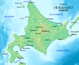
Hokkaido
Encyclopedia
, formerly known as Ezo, Yezo, Yeso, or Yesso, is Japan
's second largest island; it is also the largest and northernmost of Japan's 47 prefectural-level subdivisions
. The Tsugaru Strait
separates Hokkaido from Honshu
, although the two islands are connected by the underwater railway Seikan Tunnel
. The largest city on Hokkaido is its capital, Sapporo, which is also its only ordinance-designated city.
 Hokkaido was settled by Ainu
, Nivkh
, and Orok 20,000 years ago. The Nihon Shoki
, finished in 720, is often said to be the first mention of Hokkaido in recorded history
. According to the text, Abe no Hirafu
led a large navy and army to northern areas from 658 to 660 and came into contact with the Mishihase
and Emishi
. One of the places Hirafu went to was called Watarishima , which is often believed to be present-day Hokkaido. However, many theories exist in relation to the details of this event, including the location of Watarishima and the common belief that the Emishi in Watarishima were the ancestors of the present-day Ainu people
.
During the Nara
and Heian period
s (710–1185), people in Hokkaido conducted trade with Dewa Province
, an outpost of the Japanese central government. From the medieval ages, the people in Hokkaidō began to be called Ezo
. Around the same time Hokkaidō came to be called or Ezogashima. The Ezo mainly relied upon hunting and fishing and obtained rice and iron through trade with the Japanese.
During the Muromachi period
(1336–1573), the Japanese created a settlement at the south of the Oshima peninsula
. As more people moved to the settlement to avoid battles, disputes arose between the Japanese and the Ainu. The disputes eventually developed into a war. Takeda Nobuhiro
killed the Ainu leader, Koshamain, and defeated the opposition in 1457. Nobuhiro's descendants became the rulers of the Matsumae-han
, which was granted exclusive trading rights with the Ainu in the Azuchi-Momoyama
and Edo periods (1568–1868). The Matsumae family
's economy relied upon trade with the Ainu. They held authority over the south of Ezochi until the end of the Edo period
in 1868.
The Matsumae clan
rule over the Ainu must be understood in the context of the expansion of the Japanese feudal state. Medieval military leaders in northern Honshū maintained only tenuous political and cultural ties to the imperial court and its proxies, the Kamakura Shogunate
and Ashikaga Shogunate
. Feudal strongmen sometimes located themselves within medieval institutional order, taking shogunal titles, while in other times they assumed titles that seemed to give them a non-Japanese identity. In fact many of the feudal strongmen were descended from Emishi
military leaders who had been assimilated into Japanese society.
There were numerous revolts by the Ainu against feudal rule. The last large-scale resistance was Shakushain's Revolt
in 1669–1672. In 1789 a smaller movement, the Menashi-Kunashir Rebellion
, was also crushed. After that rebellion the terms "Japanese" and "Ainu" referred to clearly distinguished groups, and the Matsumae were unequivocally Japanese. In 1799–1821 and 1855–1858 the Edo Shogunate took direct control over Hokkaido in response to a perceived threat from Russia.
Leading up to the Meiji Restoration
, the Tokugawa Shogunate
realized there was a need to prepare northern defenses against a possible Russia
n invasion and took over control of most of Ezochi. The Shogunate made the plight of the Ainu slightly easier, but did not change the overall form of rule.
Hokkaido was known as Ezochi until the Meiji Restoration. Shortly after the Boshin War
in 1868, a group of Tokugawa loyalists led by Enomoto Takeaki
temporarily occupied the island (the polity is commonly but mistakenly known as the Republic of Ezo
), but the rebellion was crushed in May 1869. Ezochi was subsequently put under control of , Hakodate Prefectural Government). When establishing the , the Meiji Government introduced a new name. After 1869, the northern Japanese island was known as Hokkaido; and regional subdivisions were established, including the provinces of Oshima
, Shiribeshi
, Iburi
, Ishikari
, Teshio
, Kitami
, Hidaka
, Tokachi
, Kushiro
, Nemuro
and Chishima
.
 The primary purpose of the development commission was to secure Hokkaido before the Russians extended their control of the Far East beyond Vladivostok
. Kuroda Kiyotaka
was put in charge of the venture. His first step was to journey to the United States and recruit Horace Capron
, President Grant's
Commissioner of Agriculture. From 1871 to 1873 Capron bent his efforts to expounding Western agriculture and mining with mixed results. Capron, frustrated with obstacles to his efforts returned home in 1875. In 1876 William S. Clark
arrived to found an agricultural college in Sapporo. Although he only remained a year, Clark left lasting impression on Hokkaido, inspiring the Japanese with his teachings on agriculture as well as Christianity. His parting words, "Boys, be ambitious!" can be found on public buildings in Hokkaido to this day. Whatever the impact these Americans had, the population of Hokkaido boomed from 58,000 to 240,000 during that decade.
In 1882, the Development Commission was abolished, and Hokkaido was separated into three prefectures, , , and . In 1886, the three prefectures were abolished, and Hokkaido was put under the . Hokkaido became equal with other prefectures in 1947, when the revised Local Autonomy Law became effective. The Japanese central government established the as an agency of the Prime Minister
's Office in 1949 to maintain its executive power in Hokkaido. The Agency was absorbed by the Ministry of Land, Infrastructure and Transport
in 2001. and the of the Ministry still have a strong influence on public construction projects in Hokkaido.
In mid-July 1945 shipping, cities and military facilities in Hokkaido were attacked by the United States Navy's
Task Force 38
. On 14 and 15 July aircraft operating from the task force's aircraft carrier
s sank and damaged a large number of ships in ports along Hokkaido's southern coastline as well as in northern Honshu. In addition, on 15 July a force of three battleship
s and two light cruiser
s bombarded the city of Muroran
.
exonym for the Ainu, namely Qoy or kʰuɣi.
There is no established Ainu word for the island. The Ainu term aynu mosir means "the Land where people live" and was contrasted with kamuy mosir (the land of the Kamuy).

 The island of Hokkaido is located at the north end of Japan, near Russia
, and has coastlines on the Sea of Japan
, the Sea of Okhotsk
, and the Pacific Ocean
. The center of the island has a number of mountains and volcanic plateau
s, and there are coastal plains in all directions. Major cities include Sapporo
and Asahikawa
in the central region and the port of Hakodate
facing Honshu
.
The governmental jurisdiction
of Hokkaido incorporates several smaller islands, including Rishiri
, Okushiri Island
, and Rebun
. (By Japanese reckoning, Hokkaido also incorporates several of the Kuril Islands
.) Because the prefectural status of Hokkaido is denoted by the dō in its name, it is rarely referred to as "Hokkaido Prefecture", except when necessary to distinguish the governmental entity from the island.
The island ranks 21st in the world by area. It is 3.6% smaller than the island of Ireland
while Hispaniola
is 6.1% smaller than Hokkaido. By population it ranks 20th, between Ireland and Sicily
. Hokkaido's population is 4.7% less than that of the island of Ireland, and Sicily's is 12% lower than Hokkaido's.
active. Aside from numerous earthquake
s, the following volcanoes are still considered active (at least one eruption since 1850):
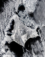
In 1993, an earthquake
of magnitude 7.8
generated a tsunami
which devastated Okushiri
, killing 202. An earthquake
of magnitude 8.0
struck near the island on September 25, 2003, at 19:50:07 (UTC).
 From April 2010 Hokkaido has 9 General Subprefectural Bureaus (総合振興局) and 4 Subprefectural Bureaus (振興局). Prior to that, Hokkaido is one of eight prefectures in Japan that have subprefectures
(支庁 shichō). However, it is the only one of the eight to have such offices covering the whole of its territory outside the main cities (rather than having them just for outlying islands or remote areas). This is mostly due to its great size: many parts of the prefecture are simply too far away to be effectively administered by Sapporo. Subprefectural offices in Hokkaidō carry out many of the duties that prefectural offices fulfill elsewhere in Japan.
Before the current political divisions and after 1869, Hokkaidō was divided into provinces. See Former Provinces of Hokkaidō
.
 Hokkaidō is known for its cool summers and icy winters. Most of the island falls in the humid continental climate
zone with Köppen climate classification
Dfb (hemiboreal
) in most areas but Dfa (humid continental) in some inland lowlands. The average August temperature ranges from 17 to 22 °C (62.6 to 71.6 F), while the average January temperature ranges from -12 C, in both cases depending on elevation and distance from the ocean, though temperatures on the western side of the island tend to be a little warmer than on the eastern.
The northern portion of Hokkaido falls into the taiga biome, with significant snowfall. Snowfall varies widely from as much as 11 metres (433.1 in) on the mountains adjacent to the Sea of Japan down to around 1.8 metres (71 in) on the Pacific coast. The island tends to see isolated snowstorms that develop long-lasting snowbanks, in contrast to the constant flurries seen in the Hokuriku region
. Total precipitation varies from 1600 millimetres (63 in) on the mountains of the Sea of Japan coast to around 800 millimetres (31.5 in) (the lowest in Japan) on the Sea of Okhotsk coast and interior lowlands and up to around 1100 millimetres (43 in) on the Pacific side.
Unlike the other major islands of Japan, Hokkaido is normally not affected by the June–July rainy season
and the relative lack of humidity and typically warm, rather than hot, summer weather makes its climate an attraction for tourists from other parts of Japan.
In winter, the generally high quality of powder snow and numerous mountains in Hokkaidō make it one of Japan's most popular regions for snow sports. The snowfall usually commences in earnest in November and ski resorts (such as those at Niseko, Furano and Rusutsu) usually operate between December and April. Hokkaido celebrates its winter weather at the Sapporo Snow Festival
.
During the winter, passage through the Sea of Okhotsk
is often complicated by large floes of drift ice
. Combined with high winds that occur during winter, this frequently brings air travel and maritime activity to a halt beyond the northern coast of Hokkaido. Ports on the open Pacific Ocean and Sea of Japan are generally ice-free year round, though all rivers freeze during the winter.
 Hokkaido's largest city is the capital, Sapporo. Other major cities include Hakodate
in the south and Asahikawa
in the central region. Other important population centers include Kushiro
, Obihiro
, Kitami
, Abashiri
, and Nemuro
.
Hokkaido has the highest rate of depopulation in Japan. In 2000, 152 (71.7%) of Hokkaido's 212 municipalities were shrinking. Altogether, shrinking municipalities in Japan in the same year numbered 1,171.
(most notably paper milling, beer brewing) most of the population is employed by the service sector. In 2001, the service sector and other tertiary industries generated more than three quarters of the gross domestic product.
However, agriculture and other primary industries play a large role in Hokkaido's economy. Hokkaido has nearly one fourth of Japan's total arable land. It ranks first in the nation in the production of a host of agricultural products, including wheat, soybeans, potatoes, sugar beet, onions, pumpkins, corn, raw milk, and beef. Hokkaido also accounts for 22% of Japan's forests with a sizable timber industry. The prefecture is also first in the nation in production of marine products and aquaculture.
Tourism is an important industry, especially during the cool summertime when visitors are attracted to Hokkaido's open spaces from hotter and more humid parts of Japan. During the winter, skiing and other winter sports bring other tourists, and increasingly international ones, to the island.
. Most travelers to the island arrive by air: the main airport is New Chitose Airport
at Chitose
, just south of Sapporo. Tokyo-Chitose is in the top 10 of the world's busiest air routes
, handling 45 widebody round trips on four airlines each day. One of the airlines, Air Do was named after Hokkaido. Hokkaido can also be reached by ferry from Sendai
, Niigata
and some other cities, with the ferries from Tokyo dealing only in cargo.
Within Hokkaido, there is a fairly well-developed railway network (see Hokkaidō Railway Company
), but many cities can only be accessed by road.
Hokkaido is home to one of Japan's three Melody Roads, which is made from grooves cut into the ground, which when driven over causes a tactile vibration and audible rumbling transmitted through the wheels into the car body.
oversees public schools (except colleges and universities) in Hokkaido. Public elementary and junior high schools (except Hokkaido Noboribetsu Akebi Secondary School and schools attached to Hokkaido University of Education) are operated by municipalities, and public high schools are operated by either the prefectural board or municipalities.
Hokkaido has 37 universities (7 national, 5 local public, and 25 private universities), 34 junior colleges, and 5 colleges of technology
(4 national and 1 local public colleges). National universities located in Hokkaido are:
Hokkaido prefectural government runs Sapporo Medical University
, a medical school in Sapporo.
were held in Sapporo.
The sports teams listed below are based in Hokkaido.
, Canada, since 1980 Heilongjiang
, China, since 1980 Massachusetts
, USA, since 1988 Sakhalin Oblast
, Russia, since 1998 Busan
, South Korea, since 2005 Gyeongsangnam-do
, South Korea, since 2006
As of July 2008, 73 individual municipalities in Hokkaido have sister city agreements with 111 cities in 19 different countries worldwide.
People from Hokkaido
Japan
Japan is an island nation in East Asia. Located in the Pacific Ocean, it lies to the east of the Sea of Japan, China, North Korea, South Korea and Russia, stretching from the Sea of Okhotsk in the north to the East China Sea and Taiwan in the south...
's second largest island; it is also the largest and northernmost of Japan's 47 prefectural-level subdivisions
Prefectures of Japan
The prefectures of Japan are the country's 47 subnational jurisdictions: one "metropolis" , Tokyo; one "circuit" , Hokkaidō; two urban prefectures , Osaka and Kyoto; and 43 other prefectures . In Japanese, they are commonly referred to as...
. The Tsugaru Strait
Tsugaru Strait
is a channel between Honshu and Hokkaido in northern Japan connecting the Sea of Japan with the Pacific Ocean. It was named after the western part of Aomori Prefecture...
separates Hokkaido from Honshu
Honshu
is the largest island of Japan. The nation's main island, it is south of Hokkaido across the Tsugaru Strait, north of Shikoku across the Inland Sea, and northeast of Kyushu across the Kanmon Strait...
, although the two islands are connected by the underwater railway Seikan Tunnel
Seikan Tunnel
The Seikan Tunnel is a railway tunnel in Japan, with a long portion under the seabed. Track level is about below seabed and below sea level. It travels beneath the Tsugaru Strait—connecting Aomori Prefecture on the Japanese island of Honshu and the island of Hokkaido—as part of the Kaikyo Line...
. The largest city on Hokkaido is its capital, Sapporo, which is also its only ordinance-designated city.
History
Ainu people
The , also called Aynu, Aino , and in historical texts Ezo , are indigenous people or groups in Japan and Russia. Historically they spoke the Ainu language and related varieties and lived in Hokkaidō, the Kuril Islands, and much of Sakhalin...
, Nivkh
Nivkh
Nivkh or Gilyak can refer to:*The Nivkh people*The Nivkh language*The Russian gunboat Gilyak, a sistership of Bobr, Sivuch and Korietz and the lead ship of her class...
, and Orok 20,000 years ago. The Nihon Shoki
Nihon Shoki
The , sometimes translated as The Chronicles of Japan, is the second oldest book of classical Japanese history. It is more elaborate and detailed than the Kojiki, the oldest, and has proven to be an important tool for historians and archaeologists as it includes the most complete extant historical...
, finished in 720, is often said to be the first mention of Hokkaido in recorded history
Recorded history
Recorded history is the period in history of the world after prehistory. It has been written down using language, or recorded using other means of communication. It starts around the 4th millennium BC, with the invention of writing.-Historical accounts:...
. According to the text, Abe no Hirafu
Abe no Hirafu
was a governor of Koshi Province. He fought against the aboriginal inhabitants of Japan . This was in 658...
led a large navy and army to northern areas from 658 to 660 and came into contact with the Mishihase
Mishihase
The , also read as Ashihase and Shukushin, were a people of ancient Japan, believed to have lived along the northern portion of the coast of the Sea of Japan...
and Emishi
Emishi
The constituted a group of people who lived in northeastern Honshū in the Tōhoku region. They are referred to as in contemporary sources. Some Emishi tribes resisted the rule of the Japanese Emperors during the late Nara and early Heian periods...
. One of the places Hirafu went to was called Watarishima , which is often believed to be present-day Hokkaido. However, many theories exist in relation to the details of this event, including the location of Watarishima and the common belief that the Emishi in Watarishima were the ancestors of the present-day Ainu people
Ainu people
The , also called Aynu, Aino , and in historical texts Ezo , are indigenous people or groups in Japan and Russia. Historically they spoke the Ainu language and related varieties and lived in Hokkaidō, the Kuril Islands, and much of Sakhalin...
.
During the Nara
Nara period
The of the history of Japan covers the years from AD 710 to 794. Empress Gemmei established the capital of Heijō-kyō . Except for 5 years , when the capital was briefly moved again, it remained the capital of Japanese civilization until Emperor Kammu established a new capital, Nagaoka-kyō, in 784...
and Heian period
Heian period
The is the last division of classical Japanese history, running from 794 to 1185. The period is named after the capital city of Heian-kyō, or modern Kyōto. It is the period in Japanese history when Buddhism, Taoism and other Chinese influences were at their height...
s (710–1185), people in Hokkaido conducted trade with Dewa Province
Dewa Province
is an old province of Japan, comprising modern-day Yamagata Prefecture and Akita Prefecture, except for the city of Kazuno and the town of Kosaka. It was sometimes called .-Historical record:...
, an outpost of the Japanese central government. From the medieval ages, the people in Hokkaidō began to be called Ezo
Ezo
is a Japanese name which historically referred to the lands to the north of Japan. It was used in various senses, sometimes meaning the northern Japanese island of Hokkaidō, and sometimes meaning lands and waters further north in the Sea of Okhotsk, like Sakhalin and the Kuril Islands...
. Around the same time Hokkaidō came to be called or Ezogashima. The Ezo mainly relied upon hunting and fishing and obtained rice and iron through trade with the Japanese.
During the Muromachi period
Muromachi period
The is a division of Japanese history running from approximately 1336 to 1573. The period marks the governance of the Muromachi or Ashikaga shogunate, which was officially established in 1338 by the first Muromachi shogun, Ashikaga Takauji, two years after the brief Kemmu restoration of imperial...
(1336–1573), the Japanese created a settlement at the south of the Oshima peninsula
Oshima Peninsula
The Oshima Peninsula is the southernmost part of Hokkaidō, the northernmost of the Japanese islands. Where the peninsula starts is open to interpretation. A more generous interpretation is to draw a line southeast from Ishikari Bay across the Ishikari Plain to Yufutsu...
. As more people moved to the settlement to avoid battles, disputes arose between the Japanese and the Ainu. The disputes eventually developed into a war. Takeda Nobuhiro
Takeda Nobuhiro
Takeda Nobuhiro , also known as Kakizaki Nobuhiro was the ancestor of the Matsumae clan, and is celebrated for his role in suppressing the 1457 Ainu revolt of Koshamain. The adopted son of Takeda Nobukata, shugo of Wakasa Province, he was later re-adopted by Kakizaki Sueshige...
killed the Ainu leader, Koshamain, and defeated the opposition in 1457. Nobuhiro's descendants became the rulers of the Matsumae-han
Matsumae clan
The was a Japanese clan which was granted the area around Matsumae, Hokkaidō as a march fief in 1590 by Toyotomi Hideyoshi, and charged with defending it, and by extension all of Japan, from the Ainu 'barbarians' to the north. The clan was originally known as the Kakizaki clan who settled...
, which was granted exclusive trading rights with the Ainu in the Azuchi-Momoyama
Azuchi-Momoyama period
The came at the end of the Warring States Period in Japan, when the political unification that preceded the establishment of the Tokugawa shogunate took place. It spans the years from approximately 1573 to 1603, during which time Oda Nobunaga and his successor, Toyotomi Hideyoshi, imposed order...
and Edo periods (1568–1868). The Matsumae family
Matsumae clan
The was a Japanese clan which was granted the area around Matsumae, Hokkaidō as a march fief in 1590 by Toyotomi Hideyoshi, and charged with defending it, and by extension all of Japan, from the Ainu 'barbarians' to the north. The clan was originally known as the Kakizaki clan who settled...
's economy relied upon trade with the Ainu. They held authority over the south of Ezochi until the end of the Edo period
Edo period
The , or , is a division of Japanese history which was ruled by the shoguns of the Tokugawa family, running from 1603 to 1868. The political entity of this period was the Tokugawa shogunate....
in 1868.
The Matsumae clan
Matsumae clan
The was a Japanese clan which was granted the area around Matsumae, Hokkaidō as a march fief in 1590 by Toyotomi Hideyoshi, and charged with defending it, and by extension all of Japan, from the Ainu 'barbarians' to the north. The clan was originally known as the Kakizaki clan who settled...
rule over the Ainu must be understood in the context of the expansion of the Japanese feudal state. Medieval military leaders in northern Honshū maintained only tenuous political and cultural ties to the imperial court and its proxies, the Kamakura Shogunate
Kamakura shogunate
The Kamakura shogunate was a military dictatorship in Japan headed by the shoguns from 1185 to 1333. It was based in Kamakura. The Kamakura period draws its name from the capital of the shogunate...
and Ashikaga Shogunate
Ashikaga shogunate
The , also known as the , was a Japanese feudal military regime, ruled by the shoguns of the Ashikaga clan.This period is also known as the Muromachi period and gets its name from Muromachi Street of Kyoto where the third shogun Ashikaga Yoshimitsu established his residence...
. Feudal strongmen sometimes located themselves within medieval institutional order, taking shogunal titles, while in other times they assumed titles that seemed to give them a non-Japanese identity. In fact many of the feudal strongmen were descended from Emishi
Emishi
The constituted a group of people who lived in northeastern Honshū in the Tōhoku region. They are referred to as in contemporary sources. Some Emishi tribes resisted the rule of the Japanese Emperors during the late Nara and early Heian periods...
military leaders who had been assimilated into Japanese society.
There were numerous revolts by the Ainu against feudal rule. The last large-scale resistance was Shakushain's Revolt
Shakushain's Revolt
was an Ainu rebellion against Japanese authority on Hokkaidō between 1669 to 1672. It was led by Ainu chieftain Shakushain against the Matsumae clan, who represented Japanese trading and governmental interests in the area of Hokkaidō then controlled by the Japanese .The war initially began as a...
in 1669–1672. In 1789 a smaller movement, the Menashi-Kunashir Rebellion
Menashi-Kunashir Rebellion
or Menashi-Kunashir Battle was a battle in 1789 between Ainu and Japanese on the Shiretoko Peninsula in northeastern Hokkaidō. It began in May, 1789 when Ainu attacked Japanese on Kunashir Island and parts of the Menashi District as well as at sea. More than 70 Japanese were killed. The Japanese...
, was also crushed. After that rebellion the terms "Japanese" and "Ainu" referred to clearly distinguished groups, and the Matsumae were unequivocally Japanese. In 1799–1821 and 1855–1858 the Edo Shogunate took direct control over Hokkaido in response to a perceived threat from Russia.
Leading up to the Meiji Restoration
Meiji Restoration
The , also known as the Meiji Ishin, Revolution, Reform or Renewal, was a chain of events that restored imperial rule to Japan in 1868...
, the Tokugawa Shogunate
Tokugawa shogunate
The Tokugawa shogunate, also known as the and the , was a feudal regime of Japan established by Tokugawa Ieyasu and ruled by the shoguns of the Tokugawa family. This period is known as the Edo period and gets its name from the capital city, Edo, which is now called Tokyo, after the name was...
realized there was a need to prepare northern defenses against a possible Russia
Russian Empire
The Russian Empire was a state that existed from 1721 until the Russian Revolution of 1917. It was the successor to the Tsardom of Russia and the predecessor of the Soviet Union...
n invasion and took over control of most of Ezochi. The Shogunate made the plight of the Ainu slightly easier, but did not change the overall form of rule.
Hokkaido was known as Ezochi until the Meiji Restoration. Shortly after the Boshin War
Boshin War
The was a civil war in Japan, fought from 1868 to 1869 between forces of the ruling Tokugawa shogunate and those seeking to return political power to the imperial court....
in 1868, a group of Tokugawa loyalists led by Enomoto Takeaki
Enomoto Takeaki
Viscount was a samurai and admiral of the Tokugawa navy of Bakumatsu period Japan, who remained faithful to the Tokugawa shogunate who fought against the new Meiji government until the end of the Boshin War...
temporarily occupied the island (the polity is commonly but mistakenly known as the Republic of Ezo
Republic of Ezo
The ' was a short-lived state established by former Tokugawa retainers in what is now known as Hokkaidō, the large but sparsely populated northernmost island in modern Japan.-Background:...
), but the rebellion was crushed in May 1869. Ezochi was subsequently put under control of , Hakodate Prefectural Government). When establishing the , the Meiji Government introduced a new name. After 1869, the northern Japanese island was known as Hokkaido; and regional subdivisions were established, including the provinces of Oshima
Oshima Province
was a short-lived province located in Hokkaidō. It corresponded to the southern part of today's Oshima and Hiyama Subprefectures-History:After 1869, the northern Japanese island was known as Hokkaido; and regional administrative subdivisions were identified, including Oshima Province.*August 15,...
, Shiribeshi
Shiribeshi Province
was a short-lived province in Hokkaidō. It corresponded to Shiribeshi Subprefecture minus Abuta District plus the northern part of Hiyama Subprefecture.-History:...
, Iburi
Iburi Province
, also called Ifuri, was a short-lived province located in Hokkaidō. It corresponds to modern-day Iburi Subprefecture, Yamakoshi District of Oshima, Abuta District in Shiribeshi Subprefecture, the cities of Chitose and Eniwa in Ishikari Subprefecture and Shimukappu Village in Kamikawa...
, Ishikari
Ishikari Province
was a short-lived province located in Hokkaidō. It corresponded to modern-day Ishikari Subprefecture minus Chitose and Eniwa, all of Sorachi Subprefecture and the southern half of Kamikawa Subprefecture excluding Shimukappu-History:...
, Teshio
Teshio Province
was a short-lived province located in Hokkaidō, corresponding to all of modern-day Rumoi Subprefecture and the northern half of Kamikawa Subprefecture.-History:...
, Kitami
Kitami Province
was a short-lived province located in Hokkaidō. It corresponded to modern-day Sōya Subprefecture and Abashiri Subprefecture minus part of Abashiri District-History:...
, Hidaka
Hidaka Province
was a short-lived province located in Hokkaidō. It corresponded to modern-day Hidaka Subprefecture.-History:After 1869, the northern Japanese island was known as Hokkaido; and regional administrative subdivisions were identified, including Hidaka Province....
, Tokachi
Tokachi Province
was a short-lived province in Hokkaidō. It corresponded to modern-day Tokachi Subprefecture.-History:After 1869, the northern Japanese island was known as Hokkaido; and regional administrative subdivisions were identified, including Tokachi Province....
, Kushiro
Kushiro Province
was a short-lived province in Hokkaidō. It corresponded to modern-day Kushiro Subprefecture and part of Abashiri Subprefecture.-History:After 1869, the northern Japanese island was known as Hokkaido; and regional administrative subdivisions were identified, including Kushiro Province.*August 15,...
, Nemuro
Nemuro Province
was an old province in Japan in what is today Nemuro Subprefecture, Hokkaidō. It was created during the Meiji Era.-History:After 1869, the northern Japanese island was known as Hokkaido; and regional administrative subdivisions were identified, including Nemuro Province.*August 15, 1869 Nemuro...
and Chishima
Chishima Province
was a province of Japan created during the Meiji Era. It originally contained the Kurile Islands from Kunashiri northwards, and later incorporated Shikotan as well...
.
Vladivostok
The city is located in the southern extremity of Muravyov-Amursky Peninsula, which is about 30 km long and approximately 12 km wide.The highest point is Mount Kholodilnik, the height of which is 257 m...
. Kuroda Kiyotaka
Kuroda Kiyotaka
, also known as , was a Japanese politician of the Meiji era. He was the second Prime Minister of Japan from 30 April 1888 to 25 October 1889.-As a Satsuma samurai:...
was put in charge of the venture. His first step was to journey to the United States and recruit Horace Capron
Horace Capron
Horace Capron was an American businessman and agriculturalist, a founder of Laurel, Maryland, a Union officer in the American Civil War, the United States Commissioner of Agriculture under U.S. Presidents Andrew Johnson and Ulysses S...
, President Grant's
Ulysses S. Grant
Ulysses S. Grant was the 18th President of the United States as well as military commander during the Civil War and post-war Reconstruction periods. Under Grant's command, the Union Army defeated the Confederate military and ended the Confederate States of America...
Commissioner of Agriculture. From 1871 to 1873 Capron bent his efforts to expounding Western agriculture and mining with mixed results. Capron, frustrated with obstacles to his efforts returned home in 1875. In 1876 William S. Clark
William S. Clark
William Smith Clark was a professor of chemistry, botany and zoology, a colonel during the American Civil War, and a leader in agricultural education. Raised and schooled in Easthampton, Massachusetts, Clark spent most of his adult life in Amherst, Massachusetts...
arrived to found an agricultural college in Sapporo. Although he only remained a year, Clark left lasting impression on Hokkaido, inspiring the Japanese with his teachings on agriculture as well as Christianity. His parting words, "Boys, be ambitious!" can be found on public buildings in Hokkaido to this day. Whatever the impact these Americans had, the population of Hokkaido boomed from 58,000 to 240,000 during that decade.
In 1882, the Development Commission was abolished, and Hokkaido was separated into three prefectures, , , and . In 1886, the three prefectures were abolished, and Hokkaido was put under the . Hokkaido became equal with other prefectures in 1947, when the revised Local Autonomy Law became effective. The Japanese central government established the as an agency of the Prime Minister
Prime Minister of Japan
The is the head of government of Japan. He is appointed by the Emperor of Japan after being designated by the Diet from among its members, and must enjoy the confidence of the House of Representatives to remain in office...
's Office in 1949 to maintain its executive power in Hokkaido. The Agency was absorbed by the Ministry of Land, Infrastructure and Transport
Ministry of Land, Infrastructure and Transport (Japan)
The , abbreviated MLIT, is a ministry of the Japanese government. It is responsible for one-third of all the laws and orders in Japan and the largest Japanese ministry in terms of employees, as well as the second-largest organ of the Japanese government after the Ministry of Defense...
in 2001. and the of the Ministry still have a strong influence on public construction projects in Hokkaido.
In mid-July 1945 shipping, cities and military facilities in Hokkaido were attacked by the United States Navy's
United States Navy
The United States Navy is the naval warfare service branch of the United States Armed Forces and one of the seven uniformed services of the United States. The U.S. Navy is the largest in the world; its battle fleet tonnage is greater than that of the next 13 largest navies combined. The U.S...
Task Force 38
Fast Carrier Task Force
The Fast Carrier Task Force was the main striking force of the United States Navy in the Pacific Ocean theatre of World War II.The Fast Carrier Task Force was known under two designations. The Navy made use of two sets of upper command structures for planning the upcoming operations...
. On 14 and 15 July aircraft operating from the task force's aircraft carrier
Aircraft carrier
An aircraft carrier is a warship designed with a primary mission of deploying and recovering aircraft, acting as a seagoing airbase. Aircraft carriers thus allow a naval force to project air power worldwide without having to depend on local bases for staging aircraft operations...
s sank and damaged a large number of ships in ports along Hokkaido's southern coastline as well as in northern Honshu. In addition, on 15 July a force of three battleship
Battleship
A battleship is a large armored warship with a main battery consisting of heavy caliber guns. Battleships were larger, better armed and armored than cruisers and destroyers. As the largest armed ships in a fleet, battleships were used to attain command of the sea and represented the apex of a...
s and two light cruiser
Light cruiser
A light cruiser is a type of small- or medium-sized warship. The term is a shortening of the phrase "light armored cruiser", describing a small ship that carried armor in the same way as an armored cruiser: a protective belt and deck...
s bombarded the city of Muroran
Allied naval bombardments of Japan during World War II
During the last weeks of World War II, warships of the United States Navy, Britain's Royal Navy and the Royal New Zealand Navy bombarded several cities and industrial facilities in Japan. These bombardments caused heavy damage to several of the factories targeted, as well as nearby civilian areas...
.
Naming of Hokkaido
When establishing the , the Meiji Government decided to change the name of Ezochi. Matsuura Takeshirō submitted six proposals, including names such as and , to the government. The government eventually decided to use the name Hokkaidō, but decided to write it as , as a compromise between and because of the similarity with names such as . According to Matsuura, the name was thought up because the Ainu called the region Kai. Historically, many peoples who had interactions with the ancestors of the Ainu called them and their islands Kuyi, Kuye, Qoy, or some similar name, which may have some connection to the early modern form Kai. The Kai element also strongly resembles the Sino-Japanese reading of the characters (Sino-Japanese ka.i, Japanese kun'yomi [emisi]), which have been used for over a thousand years in China and Japan as the standard orthographic form to be used when referring to Ainu and related peoples; it is possible that Matsuura's Kai was actually an alteration, influenced by the Sino-Japanese reading of Ka-i, of the NivkhNivkh language
Nivkh or Gilyak is a language spoken in Outer Manchuria, in the basin of the Amgun , along the lower reaches of the Amur itself, and on the northern half of Sakhalin. 'Gilyak' is the Manchu appellation...
exonym for the Ainu, namely Qoy or kʰuɣi.
There is no established Ainu word for the island. The Ainu term aynu mosir means "the Land where people live" and was contrasted with kamuy mosir (the land of the Kamuy).
Geography
Russia
Russia or , officially known as both Russia and the Russian Federation , is a country in northern Eurasia. It is a federal semi-presidential republic, comprising 83 federal subjects...
, and has coastlines on the Sea of Japan
Sea of Japan
The Sea of Japan is a marginal sea of the western Pacific Ocean, between the Asian mainland, the Japanese archipelago and Sakhalin. It is bordered by Japan, North Korea, Russia and South Korea. Like the Mediterranean Sea, it has almost no tides due to its nearly complete enclosure from the Pacific...
, the Sea of Okhotsk
Sea of Okhotsk
The Sea of Okhotsk is a marginal sea of the western Pacific Ocean, lying between the Kamchatka Peninsula on the east, the Kuril Islands on the southeast, the island of Hokkaidō to the far south, the island of Sakhalin along the west, and a long stretch of eastern Siberian coast along the west and...
, and the Pacific Ocean
Pacific Ocean
The Pacific Ocean is the largest of the Earth's oceanic divisions. It extends from the Arctic in the north to the Southern Ocean in the south, bounded by Asia and Australia in the west, and the Americas in the east.At 165.2 million square kilometres in area, this largest division of the World...
. The center of the island has a number of mountains and volcanic plateau
Volcanic plateau
A volcanic plateau is a plateau produced by volcanic activity. There are two main types: lava plateaus and pyroclastic plateaus.-Lava plateau:...
s, and there are coastal plains in all directions. Major cities include Sapporo
Sapporo, Hokkaido
is the fourth-largest city in Japan by population, and the largest city on the island of Hokkaido. It is the capital of Hokkaidō Prefecture, located in Ishikari Subprefecture, and an ordinance-designated city of Japan....
and Asahikawa
Asahikawa, Hokkaido
is a city in Kamikawa Subprefecture, Hokkaido, Japan. It is the capital of the subprefecture and the second-largest city in Hokkaido, after Sapporo. It has been a Core city since April 1, 2000...
in the central region and the port of Hakodate
Hakodate, Hokkaido
is a city and port located in Oshima Subprefecture, Hokkaido, Japan. It is the capital city of Oshima Subprefecture.Hakodate was Japan's first city whose port was opened to foreign trade in 1854 as a result of Convention of Kanagawa, and used to be the most important port in northern Japan...
facing Honshu
Honshu
is the largest island of Japan. The nation's main island, it is south of Hokkaido across the Tsugaru Strait, north of Shikoku across the Inland Sea, and northeast of Kyushu across the Kanmon Strait...
.
The governmental jurisdiction
Prefectures of Japan
The prefectures of Japan are the country's 47 subnational jurisdictions: one "metropolis" , Tokyo; one "circuit" , Hokkaidō; two urban prefectures , Osaka and Kyoto; and 43 other prefectures . In Japanese, they are commonly referred to as...
of Hokkaido incorporates several smaller islands, including Rishiri
Rishiri Island
rises out of the Sea of Japan off the coast of Hokkaidō, Japan. The island is formed by the cone-shaped extinct volcanic peak of Mount Rishiri. Along with Rebun and the coastal area of Sarobetsu, Rishiri forms the Rishiri-Rebun-Sarobetsu National Park. The main industries of Rishiri are tourism and...
, Okushiri Island
Okushiri Island
is an island in Hokkaidō, Japan. It has an area of . The town of Okushiri and Hiyama Prefectural Natural Park encompass the entire island.-History:It was the site of a powerful earthquake and tsunami in 1993....
, and Rebun
Rebun Island
Rebun Island lies in the Sea of Japan off the northwestern tip of Hokkaidō, Japan. Rebun stretches 29 kilometers in the north-south direction and 8 kilometers east-west, covering about 80 square kilometers. The island is known for its alpine flowers and the 8-Hour Hiking Course which runs from one...
. (By Japanese reckoning, Hokkaido also incorporates several of the Kuril Islands
Kuril Islands
The Kuril Islands , in Russia's Sakhalin Oblast region, form a volcanic archipelago that stretches approximately northeast from Hokkaidō, Japan, to Kamchatka, Russia, separating the Sea of Okhotsk from the North Pacific Ocean. There are 56 islands and many more minor rocks. It consists of Greater...
.) Because the prefectural status of Hokkaido is denoted by the dō in its name, it is rarely referred to as "Hokkaido Prefecture", except when necessary to distinguish the governmental entity from the island.
The island ranks 21st in the world by area. It is 3.6% smaller than the island of Ireland
Ireland
Ireland is an island to the northwest of continental Europe. It is the third-largest island in Europe and the twentieth-largest island on Earth...
while Hispaniola
Hispaniola
Hispaniola is a major island in the Caribbean, containing the two sovereign states of the Dominican Republic and Haiti. The island is located between the islands of Cuba to the west and Puerto Rico to the east, within the hurricane belt...
is 6.1% smaller than Hokkaido. By population it ranks 20th, between Ireland and Sicily
Sicily
Sicily is a region of Italy, and is the largest island in the Mediterranean Sea. Along with the surrounding minor islands, it constitutes an autonomous region of Italy, the Regione Autonoma Siciliana Sicily has a rich and unique culture, especially with regard to the arts, music, literature,...
. Hokkaido's population is 4.7% less than that of the island of Ireland, and Sicily's is 12% lower than Hokkaido's.
Seismic activity
Like the rest of Japan, Hokkaido is seismicallySeismology
Seismology is the scientific study of earthquakes and the propagation of elastic waves through the Earth or through other planet-like bodies. The field also includes studies of earthquake effects, such as tsunamis as well as diverse seismic sources such as volcanic, tectonic, oceanic,...
active. Aside from numerous earthquake
Earthquake
An earthquake is the result of a sudden release of energy in the Earth's crust that creates seismic waves. The seismicity, seismism or seismic activity of an area refers to the frequency, type and size of earthquakes experienced over a period of time...
s, the following volcanoes are still considered active (at least one eruption since 1850):
- Mount Koma
- Mount UsuMount Usuis an active stratovolcano in the Shikotsu-Toya National Park, Hokkaidō, Japan. It has erupted four times since 1900: in 1910, 1944–45 , August 7, 1977, and on March 31, 2000. To the north lies Lake Toya...
and ShowashinzanShowashinzanis a volcanic lava dome in the Shikotsu-Toya National Park, Hokkaidō, Japan, next to Mount Usu. The mountain was created between 1944 and 1945. Initially, a series of strong earthquakes shook the area, and wheat fields were rapidly uplifted. Lava broke through the surface and the current peak... - Mount TarumaeMount Tarumaeis located in the Shikotsu-Toya National Park in Hokkaidō, Japan. It is located near both Tomakomai and Chitose towns and can be seen clearly from both. It is on the shores of Lake Shikotsu, a caldera lake. Tarumae is a 1,041 metre active andesitic stratovolcano, with a lava dome.-Eruptions:The...
- Mount TokachiMount Tokachi (Daisetsuzan)is an active volcano located in Daisetsuzan National Park, Hokkaidō, Japan. It is the tallest volcano of the Tokachi Volcanic Group. It is one of the 100 famous mountains in Japan....
- Mount MeakanMount Meakanis an active stratovolcano located in Akan National Park in Hokkaidō, Japan. It is the tallest mountain in the Akan Volcanic Complex.The volcano consists of nine overlapping cones that grew out of the Akan caldera, on the shores of Lake Akan. Mount Meakan has a triple crater at its summit...
In 1993, an earthquake
1993 Hokkaidō earthquake
The occurred at 13:17:12 UTC on in the Sea of Japan near the island of Hokkaido. It had a magnitude of 7.7 on the moment magnitude scale and a maximum felt intensity of VIII on the Mercalli intensity scale. It triggered a major tsunami that caused deaths on Hokkaidō and in southeastern Russia,...
of magnitude 7.8
Richter magnitude scale
The expression Richter magnitude scale refers to a number of ways to assign a single number to quantify the energy contained in an earthquake....
generated a tsunami
Tsunami
A tsunami is a series of water waves caused by the displacement of a large volume of a body of water, typically an ocean or a large lake...
which devastated Okushiri
Okushiri, Hokkaido
is a town encompassing all of Okushiri Island, located in Okushiri District, Hiyama, Hokkaidō, Japan.As of 2008, the town has an estimated population of 3,442 and a density of 24.5 persons per km²...
, killing 202. An earthquake
Earthquake
An earthquake is the result of a sudden release of energy in the Earth's crust that creates seismic waves. The seismicity, seismism or seismic activity of an area refers to the frequency, type and size of earthquakes experienced over a period of time...
of magnitude 8.0
Richter magnitude scale
The expression Richter magnitude scale refers to a number of ways to assign a single number to quantify the energy contained in an earthquake....
struck near the island on September 25, 2003, at 19:50:07 (UTC).
National Parks and quasi-national parks
There are still many undisturbed forests in Hokkaido, including:| National parks | |
|---|---|
| Shiretoko National Park Shiretoko National Park covers most of the Shiretoko Peninsula at the northeastern tip of the island of Hokkaidō, Japan.The word "Shiretoko" is derived form an Ainu word "sir etok", meaning "end of the Earth".... * |
知床 |
| Akan National Park Akan National Park is a national park located on the island of Hokkaidō, Japan. Along with Daisetsuzan National Park, these are the two oldest national parks in Hokkaidō. The park was established December 4, 1934.... |
阿寒 |
| Kushiro Shitsugen National Park Kushiro Shitsugen National Park is a national park located in the east of the island of Hokkaidō, Japan. It was designated as a national park on 31 July 1987, and is the 28th and most recent of Japan's national parks. The park is known for its wetlands ecosystems.... |
釧路湿原 |
| Daisetsuzan National Park Daisetsuzan National Park , or Taisetsuzan is located in the mountainous center of the northern Japanese island of Hokkaidō. At 2267.64 square kilometers, Daisetsuzan is the largest national park in Japan.... |
大雪山 |
| Shikotsu-Toya National Park Shikotsu-Toya National Park is a national park in the central part of the island of Hokkaidō, Japan. Named after the volcanic caldera lakes of Lake Shikotsu and Lake Tōya, it has a total area of 993.02 square kilometers... |
支笏洞爺 |
| Rishiri-Rebun-Sarobetsu National Park Rishiri-Rebun-Sarobetsu National Park is a national park on the Rishiri Island, Rebun Island, coasts of Wakkanai and Wakkasakanai and Sarobetsu Plain and the north-western edge of Hokkaidō, Japan.-External links:* http://www.biodic.go.jp/english/jpark/np/risiri_e.html... |
利尻礼文サロベツ |
| Quasi-national parks (準国立公園) | |
|---|---|
| Abashiri Quasi-National Park Abashiri Quasi-National Park is a quasi-national park in Japan. The park protects the waters and surrounding coastline of the lakes and lagoons along the Sea of Okhotsk on Hokkaidō. This includes such lakes as Lake Abashiri and Lake Notoro as well as Lake Tōfutsu and Lake Saroma. Lake Saroma is the fourth largest lake in Japan... |
網走 |
| Hidaka Sanmyaku-Erimo Quasi-National Park Hidaka Sanmyaku-Erimo Quasi-National Park is the largest quasi-national park in Japan. The park includes the Hidaka Mountains and Cape Erimo and is located in southeast Hokkaidō. The park was designated Erimo Prefectural Park in 1950 and Erimo Prefectural Nature Park in 1958 until it was raised to a quasi-national in 1981... |
日高山脈襟裳 |
| Niseko-Shakotan-Otaru Kaigan Quasi-National Park Niseko-Shakotan-Otaru Kaigan Quasi-National Park is a quasi-national park in Hokkaidō, Japan. On the coast of the Sea of Japan, there is a Marine Protected Area covering the west and north coast of Shakotan peninsula from Kamoenai to Otaru... |
ニセコ積丹小樽海岸 |
| Ōnuma Quasi-National Park Onuma Quasi-National Park is a quasi-national park on the Oshima Peninsula in southwest Hokkaidō, Japan. The park encompasses the volcanic as well as the and ponds, which abut against the west slope of the mountain... |
大沼 |
| Shokanbetsu-Teuri-Yagishiri Quasi-National Park Shokanbetsu-Teuri-Yagishiri Quasi-National Park is a quasi-national park in Hokkaidō, Japan.The park include the following areas:* Mashike Mountains* Teuri Island* Yagishiri Island... |
暑寒別天売焼尻 |
- Twelve prefectural natural parks (道立自然公園). The prefectural natural parks cover 146,802 ha, the largest area of any prefecture.
- Akkeshi Prefectural Natural Park
- Furano Ashibetsu Prefectural Natural Park
- Hiyama Prefectural Natural ParkHiyama Prefectural Natural Parkis a prefectural natural park of Hokkaidō, Japan. The park encompasses over , including all of Okushiri Island and parts of the following towns of Hiyama Subprefecture:*Esashi*Kaminokuni*Otobe*TaiseiThe park also includes Kamome Island in Esashi....
- Kamome Island Prefectural Natural Park
- Kariba-Motta Prefectural Natural Park
- Kita Okhotsk Prefectural Natural Park
- Matsumae-Yagoshi Prefectural Natural Park
- Nopporo Forest Park Nopporo Shinrin Prefectural Natural Park
- Notsuke-Furen Prefectural Natural Park
- Okumonobe Prefectural Natural Park
- Sharidake Prefectural Natiural Park
- Teshiodake Prefectural Natural Park
| Ramsar sites Ramsar Convention The Ramsar Convention is an international treaty for the conservation and sustainable utilization of wetlands, i.e., to stem the progressive encroachment on and loss of wetlands now and in the future, recognizing the fundamental ecological functions of wetlands and their economic, cultural,... |
||
|---|---|---|
| Kushiro Wetland | :ja:釧路湿原 | |
| Lake Kutcharo | :ja:クッチャロ湖 | |
| Lake Utonai | :ja:ウトナイ湖 | |
| Kiritappu Wetland Kiritappu Wetland is a 3,168ha. wetland area in Hamanaka-cho, Akkeshi District, Hokkaidō, Japan. It is also called because numerous flowers can be seen in summer.Kiritappu wetland is the third largest wetland in Japan, following the Kushiro Shitsugen National Park and Sarobetsu field.The peatland in the center of... |
:ja:霧多布湿原 | |
| Lake Akkeshi Lake Akkeshi is a brackish lake near Akkeshi in Hokkaidō, Japan. The wetlands of Lake Akkeshi and have been designated a Ramsar Site.-Wetlands:Lake Akkeshi, 11m deep at its deepest point, is fed by the and adjoins Akkeshi Bay. It is surrounded by salt marsh, fens, and bogs.-Birds:Since the lake does not... , Bekkanbeushi Wetland |
:ja:厚岸湖・別寒辺牛湿原 | |
| Miyajima Marsh | :ja:宮島沼 | |
| Uryūnuma Wetland | :ja:雨竜沼湿原 | |
| Sarobetsu Mire | :ja:サロベツ原野 | |
| Lake Tōfutsu | :ja:濤沸湖 | |
| Lake Akan Lake Akan is a lake in Kushiro, Hokkaidō, Japan. It is located in Akan National Park and is a Ramsar Site.-History:Volcanic activity formed the lake some 6,000 years ago, when a dam was formed. The lake used to have a clarity of 8–9 meters in the 1930s. Pollution from local hotspring resorts has decreased... |
:ja:阿寒湖 | |
| Notsuke Peninsula, Notsuke Bay | :ja:野付半島・:ja:野付湾 | |
| Lake Fūren Lake Furen is a brackish lake near Nemuro in Hokkaidō, Japan. The wetlands of Lake Furen and the dunes have been designated a Ramsar Site.... , Shunkunitai |
:ja:風蓮湖・:ja:春国岱 |
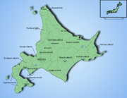
Subprefectures
Subprefectures of Japan
Certain prefectures of Japan are now, or once were, divided into subprefectures. The subprefecture is the jurisdiction surrounding a of the prefectural government. Normally, the area of a subprefecture consists of a few to a dozen cities, towns, and/or villages. Subprefectures are formed to...
(支庁 shichō). However, it is the only one of the eight to have such offices covering the whole of its territory outside the main cities (rather than having them just for outlying islands or remote areas). This is mostly due to its great size: many parts of the prefecture are simply too far away to be effectively administered by Sapporo. Subprefectural offices in Hokkaidō carry out many of the duties that prefectural offices fulfill elsewhere in Japan.
- HidakaHidaka Subprefectureis a subprefecture of Hokkaidō, Japan. The west side of the Hidaka mountains occupies most of the area. Hidaka is sparsely populated and has many of Hokkaidō's natural resources...
- HiyamaHiyama Subprefectureis a subprefecture of Hokkaidō, Japan located on the Oshima Peninsula on the Sea of Japan side. It includes Okushiri Island. It was established in 1897.-Towns and villages by district:* Hiyama District** Assabu** Esashi ** Kaminokuni* Kudō District...
- IburiIburi Subprefectureis a subprefecture of Hokkaidō, Japan.- Geography :Located in south-central Hokkaido, Iburi stretches East-West and North-South. Iburi covers an area of . Iburi borders Oshima subprefecture to the West, Shiribeshi, Ishikari, and Sorachi subprefectures to the North, and Hidaka subprefecture to the...
- IshikariIshikari Subprefectureis a subprefecture of Hokkaidō prefecture, Japan, located in the western part of the island. Its population in 2003 was 2,279,943.There are 6 cities, three towns, and one village under its jurisdiction. The subprefectural capital is Sapporo, also the capital of Hokkaidō prefecture...
- KamikawaKamikawa Subprefectureis a subprefecture of Hokkaidō, Japan. The name is derived from Kamikawa no hitobito no Shūraku , a translation of the Ainu Peni Unguri Kotan. Settlement began in 1867...
- KushiroKushiro Subprefectureis a subprefecture of Hokkaidō, Japan.-Towns and villages by district:* Akan District** Tsurui* Akkeshi District** Akkeshi** Hamanaka* Kawakami District** Shibecha** Teshikaga* Kushiro District** Kushiro* Shiranuka District** Shiranuka- History :...
- NemuroNemuro Subprefectureis a subprefecture of Hokkaidō, Japan. The Japanese claim the disputed Southern Kurile Islands as part of this subprefecture....
- OkhotskOkhotsk Subprefectureis a subprefecture of Hokkaido, Japan. It was renamed from the earlier Abashiri Subprefecture on April 1, 2010. Abashiri Subprefecture was established in 1897.-Naming:Abashiri Prefecture was named after the subprefectural office in Abashiri...
- OshimaOshima Subprefectureis a subprefecture of Hokkaidō, Japan. As of 2004 it had a population of 456,621 and an area of 3,715.38 km².Hakodate Airport is located in the City of Hakodate.- Geography :-Towns and villages by district:* Futami District** Yakumo* Kameda District...
- RumoiRumoi Subprefectureis a subprefecture of Hokkaidō, Japan. As of 2004, it had a population of 63,406 and an area of 4,019.97km².-Towns and villages by district:* Mashike District** Mashike* Rumoi District** Obira* Teshio District** Enbetsu** Horonobe** Teshio...
- ShiribeshiShiribeshi Subprefectureis a subprefecture of Hokkaidō, Japan. The subprefecture's capital is Kutchan. As of July 31, 2004, the estimated population was 256,184 and the area was 4,305.65 km².- Towns and villages by district :* Abuta District** Kimobetsu...
- SorachiSorachi Subprefectureis a subprefecture of Hokkaidō, Japan. As of 2004, its estimated population is 373,736 and its area is 6,558.26 km².-Cities:* Akabira* Ashibetsu* Bibai* Fukagawa* Iwamizawa * Mikasa* Sunagawa* Takikawa* Utashinai* Yūbari...
- SōyaSoya Subprefectureis a subprefecture of Hokkaidō, Japan. Its population is estimated to be 77,500 as of July 31, 2004 and its area is 4,050.84 km². It is the northernmost subprefecture of Japan.Wakkanai Airport is located in Wakkanai...
- TokachiTokachi Subprefectureis a subprefecture of Hokkaidō, Japan corresponding to the old province of Tokachi. As of 2004 its estimated population is 360,802 and its area is 10,830.99 km².Tokachi-Obihiro Airport is in the city of Obihiro.- Geography :-Towns and villages by district:...
Before the current political divisions and after 1869, Hokkaidō was divided into provinces. See Former Provinces of Hokkaidō
Former Provinces of Hokkaido
In 1869, the island of Hokkaidō, Japan was divided into 11 provinces and 86 districts. The majority of Japan's former provinces were converted into prefectures by the Meiji government between 1870 and 1876....
.
Climate
Humid continental climate
A humid continental climate is a climatic region typified by large seasonal temperature differences, with warm to hot summers and cold winters....
zone with Köppen climate classification
Köppen climate classification
The Köppen climate classification is one of the most widely used climate classification systems. It was first published by Crimea German climatologist Wladimir Köppen in 1884, with several later modifications by Köppen himself, notably in 1918 and 1936...
Dfb (hemiboreal
Hemiboreal
Hemiboreal means halfway between the temperate and subarctic zones. The term is most frequently used in the context of ecosystems.-Botany:...
) in most areas but Dfa (humid continental) in some inland lowlands. The average August temperature ranges from 17 to 22 °C (62.6 to 71.6 F), while the average January temperature ranges from -12 C, in both cases depending on elevation and distance from the ocean, though temperatures on the western side of the island tend to be a little warmer than on the eastern.
The northern portion of Hokkaido falls into the taiga biome, with significant snowfall. Snowfall varies widely from as much as 11 metres (433.1 in) on the mountains adjacent to the Sea of Japan down to around 1.8 metres (71 in) on the Pacific coast. The island tends to see isolated snowstorms that develop long-lasting snowbanks, in contrast to the constant flurries seen in the Hokuriku region
Hokuriku region
The is located in the northwestern part of Honshū, the main island of Japan. It lies along the Sea of Japan within the Chūbu region. It is almost equivalent to Koshi Province and Hokurikudō area in pre-modern Japan....
. Total precipitation varies from 1600 millimetres (63 in) on the mountains of the Sea of Japan coast to around 800 millimetres (31.5 in) (the lowest in Japan) on the Sea of Okhotsk coast and interior lowlands and up to around 1100 millimetres (43 in) on the Pacific side.
Unlike the other major islands of Japan, Hokkaido is normally not affected by the June–July rainy season
Wet season
The the wet season, or rainy season, is the time of year, covering one or more months, when most of the average annual rainfall in a region occurs. The term green season is also sometimes used as a euphemism by tourist authorities. Areas with wet seasons are dispersed across portions of the...
and the relative lack of humidity and typically warm, rather than hot, summer weather makes its climate an attraction for tourists from other parts of Japan.
In winter, the generally high quality of powder snow and numerous mountains in Hokkaidō make it one of Japan's most popular regions for snow sports. The snowfall usually commences in earnest in November and ski resorts (such as those at Niseko, Furano and Rusutsu) usually operate between December and April. Hokkaido celebrates its winter weather at the Sapporo Snow Festival
Sapporo Snow Festival
The is a famous festival held annually in Sapporo, Japan over seven days in February. Currently, Odori Park, Susukino, and Tsudome are the main sites of the festival. The 2012 Yuki-matsuri dates are February 6 to 12.-Overview:...
.
During the winter, passage through the Sea of Okhotsk
Sea of Okhotsk
The Sea of Okhotsk is a marginal sea of the western Pacific Ocean, lying between the Kamchatka Peninsula on the east, the Kuril Islands on the southeast, the island of Hokkaidō to the far south, the island of Sakhalin along the west, and a long stretch of eastern Siberian coast along the west and...
is often complicated by large floes of drift ice
Drift ice
Drift ice is ice that floats on the surface of the water in cold regions, as opposed to fast ice, which is attached to a shore. Usually drift ice is carried along by winds and sea currents, hence its name, "drift ice"....
. Combined with high winds that occur during winter, this frequently brings air travel and maritime activity to a halt beyond the northern coast of Hokkaido. Ports on the open Pacific Ocean and Sea of Japan are generally ice-free year round, though all rivers freeze during the winter.
Major cities and towns
Hakodate, Hokkaido
is a city and port located in Oshima Subprefecture, Hokkaido, Japan. It is the capital city of Oshima Subprefecture.Hakodate was Japan's first city whose port was opened to foreign trade in 1854 as a result of Convention of Kanagawa, and used to be the most important port in northern Japan...
in the south and Asahikawa
Asahikawa, Hokkaido
is a city in Kamikawa Subprefecture, Hokkaido, Japan. It is the capital of the subprefecture and the second-largest city in Hokkaido, after Sapporo. It has been a Core city since April 1, 2000...
in the central region. Other important population centers include Kushiro
Kushiro, Hokkaido
is a city located in Kushiro Subprefecture, Hokkaidō, Japan. It is the capital city of Kushiro Subprefecture, as well as the most populous city in eastern Hokkaidō....
, Obihiro
Obihiro, Hokkaido
is a city located in Tokachi, Hokkaidō, Japan. Obihiro is the only city in the Tokachi area. The next most populous municipality in Tokachi is the town of Otofuke, with less than a third of Obihiro's population. The city has approximately 500 foreign residents . The city contains the headquarters...
, Kitami
Kitami, Hokkaido
is a city located in Okhotsk Subprefecture, Hokkaido, Japan. It is the most populous city and the commercial center in the subprefecture, although the subprefectural capital is Abashiri.Kitami is in central Okhotsk Subprefecture. The Kitami Mountains are nearby....
, Abashiri
Abashiri, Hokkaido
is a city located in Okhotsk Subprefecture, Hokkaido, Japan.Abashiri is known as the site of the Abashiri Prison, a Meiji-era facility used for the incarceration of political prisoners...
, and Nemuro
Nemuro, Hokkaido
-Transportation:Nearby Nakashibetsu Airport serves Nemuro.-Railways:*Hokkaido Railway Company – Nemuro Main Line**Stations in the city: Nemuro, Higashi-Nemuro, Hanasaki, Nishi-Wada, Kombumori, Ochiishi, Bettoga, Hattaushi, Attoko-Sightseeing:*Cape Nosappu...
.
Hokkaido has the highest rate of depopulation in Japan. In 2000, 152 (71.7%) of Hokkaido's 212 municipalities were shrinking. Altogether, shrinking municipalities in Japan in the same year numbered 1,171.
Economy
Although there is some light industryLight industry
Light industry is usually less capital intensive than heavy industry, and is more consumer-oriented than business-oriented...
(most notably paper milling, beer brewing) most of the population is employed by the service sector. In 2001, the service sector and other tertiary industries generated more than three quarters of the gross domestic product.
However, agriculture and other primary industries play a large role in Hokkaido's economy. Hokkaido has nearly one fourth of Japan's total arable land. It ranks first in the nation in the production of a host of agricultural products, including wheat, soybeans, potatoes, sugar beet, onions, pumpkins, corn, raw milk, and beef. Hokkaido also accounts for 22% of Japan's forests with a sizable timber industry. The prefecture is also first in the nation in production of marine products and aquaculture.
Tourism is an important industry, especially during the cool summertime when visitors are attracted to Hokkaido's open spaces from hotter and more humid parts of Japan. During the winter, skiing and other winter sports bring other tourists, and increasingly international ones, to the island.
Transportation
Hokkaido's only land link to the rest of Japan is the Seikan TunnelSeikan Tunnel
The Seikan Tunnel is a railway tunnel in Japan, with a long portion under the seabed. Track level is about below seabed and below sea level. It travels beneath the Tsugaru Strait—connecting Aomori Prefecture on the Japanese island of Honshu and the island of Hokkaido—as part of the Kaikyo Line...
. Most travelers to the island arrive by air: the main airport is New Chitose Airport
New Chitose Airport
, is an airport located south southeast of Chitose and Tomakomai, Hokkaidō, Japan, serving the Sapporo metropolitan area. By land area, it is the largest airport in Hokkaidō....
at Chitose
Chitose, Hokkaido
-Economy:China Airlines operates its Sapporo office on the third floor of the airport building.The airline Hokkaido Air System was at one time headquartered at the New Chitose Airport in Chitose...
, just south of Sapporo. Tokyo-Chitose is in the top 10 of the world's busiest air routes
World's busiest passenger air routes
The busiest air routes in the world appear to involve pairs of large cities in close proximity, but which rely more on air transport due to a lack of High Speed Rail, and the distance is large enough to discourage car driving...
, handling 45 widebody round trips on four airlines each day. One of the airlines, Air Do was named after Hokkaido. Hokkaido can also be reached by ferry from Sendai
Sendai, Miyagi
is the capital city of Miyagi Prefecture, Japan, and the largest city in the Tōhoku Region. In 2005, the city had a population of one million, and was one of Japan's 19 designated cities...
, Niigata
Niigata, Niigata
is the capital and the most populous city of Niigata Prefecture, Japan. It lies on the northwest coast of Honshu, the largest island of Japan, and faces the Sea of Japan and Sado Island....
and some other cities, with the ferries from Tokyo dealing only in cargo.
Within Hokkaido, there is a fairly well-developed railway network (see Hokkaidō Railway Company
Hokkaido Railway Company
The is one of the constituent companies of Japan Railways Group , and thus often known as . It operates intercity rail services in Hokkaido, Japan. The company introduced Kitaca, a smart card ticketing system, from autumn 2008....
), but many cities can only be accessed by road.
Hokkaido is home to one of Japan's three Melody Roads, which is made from grooves cut into the ground, which when driven over causes a tactile vibration and audible rumbling transmitted through the wheels into the car body.
Education
The Hokkaidō Prefectural Board of EducationHokkaido Prefectural Board of Education
Hokkaido Prefectural Board of Education is a governmental agency that mainly oversees public schools in Hokkaidō in Japan.The board directly oversees high schools and provides educational services in Hokkaidō.-Abashiri:...
oversees public schools (except colleges and universities) in Hokkaido. Public elementary and junior high schools (except Hokkaido Noboribetsu Akebi Secondary School and schools attached to Hokkaido University of Education) are operated by municipalities, and public high schools are operated by either the prefectural board or municipalities.
Hokkaido has 37 universities (7 national, 5 local public, and 25 private universities), 34 junior colleges, and 5 colleges of technology
Colleges of technology in Japan
College of technology is the word used in Japan today for the English translation of kōsen school system, a 5-year college, while some traditional 4-year colleges have been using the word for their specific names, and some kōsen schools have their own English names that differ from college of...
(4 national and 1 local public colleges). National universities located in Hokkaido are:
- Hokkaido UniversityHokkaido UniversityHokkaido University is one of the most prestigious universities in Japan. It can be seen in the several rankings such as shown below.-General Rankings:...
(former Sapporo Agricultural CollegeSapporo Agricultural Collegewas a school in Sapporo established in the purpose of education of student who would pioneer Hokkaidō by Kaitakushi, the local government of Hokkaidō in those days...
) - Hokkaido University of EducationHokkaido University of EducationHokkaido University of Education has 5 campuses located around Hokkaidō, Japan. It is a national, public university, administered by the government of Japan. The main campus is located on the outskirts of Sapporo, the capital of Hokkaidō...
- Muroran Institute of TechnologyMuroran Institute of Technology, abbreviated as MuroranIT or MuIT, is a national university in Muroran, Hokkaidō, Japan. The predecessor of the school was founded in 1887, and it was chartered as a university in 1949....
- Otaru University of CommerceOtaru University of Commerceis one of the most difficult University in Japan--also --- national universities in Japan. Most of graduate get a job in elite companies. The main campus of the university is located in Otaru, Hokkaidō, Japan, and the satellite campus is located in Chūō-ku, Sapporo.- History :The origin of the...
- Obihiro University of Agriculture and Veterinary MedicineObihiro University of Agriculture and Veterinary Medicine, is a university located in Obihiro, Hokkaidō, Japan. Commonly referred to as the Obihiro University, it is the only national university of agriculture and veterinary medicine in Japan...
- Asahikawa Medical UniversityAsahikawa Medical University, , or AMU, is a national university and medical school in Asahikawa, Japan.- History :The precursor of Asahikawa Medical University is the founded in Yuzhno-Sakhalinsk in 1943. After World War II, Karahuto Medical College was closed down because the nearby island of Sakhalin was occupied by the...
- Kitami Institute of TechnologyKitami Institute of Technologyis a national university in Kitami, Hokkaidō, Japan. Founded as the Kitami Junior College of Technology on 1 April 1960, it was chartered as a university on 1 April 1966. In 2004, it became part of the National University Corporation....
Hokkaido prefectural government runs Sapporo Medical University
Sapporo Medical University
is a public university in Chūō-ku, Sapporo, Hokkaidō, Japan. The precursor of the school was founded in 1945, and it was chartered as a university in 1950.- History :The , the precursor of the university, was founded in 1945...
, a medical school in Sapporo.
Sports
The 1972 Winter Olympics1972 Winter Olympics
The 1972 Winter Olympics, officially known as the XI Olympic Winter Games, were a winter multi-sport event which was celebrated from February 3 to February 13, 1972 in Sapporo, Hokkaidō, Japan...
were held in Sapporo.
The sports teams listed below are based in Hokkaido.
Ice Hockey
- Nippon Paper CranesNippon Paper CranesThe are an Asia League Ice Hockey team based in Kushiro City in Hokkaidō, Japan.The club were founded as Jūjō Paper Kushiro Ice Hockey Club in 1949. They adopted the new name Nippon Paper Cranes in 1994 when Jūjō Paper and Sanyō Kokusaku Pulp merged to form Nippon Paper.They won the inaugural...
(KushiroKushiro, Hokkaidois a city located in Kushiro Subprefecture, Hokkaidō, Japan. It is the capital city of Kushiro Subprefecture, as well as the most populous city in eastern Hokkaidō....
) - Oji Ice Hockey Team (TomakomaiTomakomai, Hokkaidois a city and port located in Iburi, Hokkaido, Japan. Though its name implies a small, idyllic town, it is the largest city in the Iburi Subprefecture. As of 2008, it had an estimated population of 173,504 and a population density of 310 persons per km²...
)
International relations
Hokkaido has relationships with several provinces, states, and other entities worldwide. AlbertaAlberta
Alberta is a province of Canada. It had an estimated population of 3.7 million in 2010 making it the most populous of Canada's three prairie provinces...
, Canada, since 1980 Heilongjiang
Heilongjiang
For the river known in Mandarin as Heilong Jiang, see Amur River' is a province of the People's Republic of China located in the northeastern part of the country. "Heilongjiang" literally means Black Dragon River, which is the Chinese name for the Amur. The one-character abbreviation is 黑...
, China, since 1980 Massachusetts
Massachusetts
The Commonwealth of Massachusetts is a state in the New England region of the northeastern United States of America. It is bordered by Rhode Island and Connecticut to the south, New York to the west, and Vermont and New Hampshire to the north; at its east lies the Atlantic Ocean. As of the 2010...
, USA, since 1988 Sakhalin Oblast
Sakhalin Oblast
Sakhalin Oblast is a federal subject of Russia comprising the island of Sakhalin and the Kuril Islands.The oblast has an area of 87,100 km² and a population of 546,695...
, Russia, since 1998 Busan
Busan
Busan , formerly spelled Pusan is South Korea's second largest metropolis after Seoul, with a population of around 3.6 million. The Metropolitan area population is 4,399,515 as of 2010. It is the largest port city in South Korea and the fifth largest port in the world...
, South Korea, since 2005 Gyeongsangnam-do
Gyeongsangnam-do
Gyeongsangnam-do is a province in the southeast of South Korea. The provincial capital is located at Changwon. It contains the major metropolitan center and port of Busan. Located there is UNESCO World Heritage Site Haeinsa, a Buddhist temple that houses the Tripitaka Koreana and attracts many...
, South Korea, since 2006
As of July 2008, 73 individual municipalities in Hokkaido have sister city agreements with 111 cities in 19 different countries worldwide.
See also
- 2006 Kuril Islands earthquake2006 Kuril Islands earthquakeThe 2006 Kuril Islands earthquake was an 8.3 magnitude earthquake that hit the Kuril Islands at 11:14 UTC on November 15, 2006. A small tsunami hit the Japanese northern coast, with a larger wave following earlier small ones, due to reflection. The tsunami crossed the Pacific and did damage in...
- 2006 Kuril Islands tsunami
- Asia League Ice HockeyAsia League Ice HockeyAsia League Ice Hockey is an association which operates a professional ice hockey league based in East Asia, with seven teams from Japan, China, and South Korea. The league is headquartered in Japan...
- Former Hokkaidō government office buildingFormer Hokkaido government office buildingis an American-neo-baroque structure constructed in 1888 as a base of the Hokkaidō administration. The nickname is Akarenga or "Red Brick." It is the symbol of Hokkaidō and was designated a Japanese Important Cultural Property in 1969...
- Kuril islands disputeKuril Islands disputeThe Kuril Islands dispute , also known as the , is a dispute between Japan and Russia over sovereignty over the South Kuril Islands. The disputed islands, which were occupied by Soviet forces during the Manchurian Strategic Offensive Operation at the end of World War II, are under Russian...
People from Hokkaido
- Sankebetsu brown bear incidentSankebetsu brown bear incidentThe , also referred to as the or the was the worst bear attack in Japanese history, killing seven settlers in Rokusensawa, Sankebetsu, Tomamae, Rumoi, Hokkaidō, Japan....