

Moeraki Boulders
Encyclopedia
Otago
Otago is a region of New Zealand in the south of the South Island. The region covers an area of approximately making it the country's second largest region. The population of Otago is...
coast of New Zealand
New Zealand
New Zealand is an island country in the south-western Pacific Ocean comprising two main landmasses and numerous smaller islands. The country is situated some east of Australia across the Tasman Sea, and roughly south of the Pacific island nations of New Caledonia, Fiji, and Tonga...
between Moeraki and Hampden
Hampden, New Zealand
Hampden is a rural settlement defined as a "populated area less than a town" in North Otago, New Zealand. It is located close to the North Otago coast, some 30 kilometres south of Oamaru, and 50 minutes north of Otago's largest city, Dunedin. It was named after the English politician John Hampden...
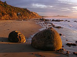
, and are located at 45°20′42.99"S 170°49′33.82"E. They occur scattered either as isolated or clusters of boulders within a stretch of beach where they have been protected in a scientific reserve. The erosion by wave action of mudstone
Mudstone
Mudstone is a fine grained sedimentary rock whose original constituents were clays or muds. Grain size is up to 0.0625 mm with individual grains too small to be distinguished without a microscope. With increased pressure over time the platey clay minerals may become aligned, with the...
, comprising local bedrock and landslides, frequently exposes embedded isolated boulders. These boulders are grey-colored septarian concretions, which have been exhumed from the mudstone enclosing them and concentrated on the beach by coastal erosion.
Local Māori legends explained the boulders as the remains of eel baskets, calabash
Calabash
Lagenaria siceraria , bottle gourd, opo squash or long melon is a vine grown for its fruit, which can either be harvested young and used as a vegetable, or harvested mature, dried, and used as a bottle, utensil, or pipe. For this reason, the calabash is widely known as the bottle gourd...
es, and kumara
Sweet potato
The sweet potato is a dicotyledonous plant that belongs to the family Convolvulaceae. Its large, starchy, sweet-tasting, tuberous roots are an important root vegetable. The young leaves and shoots are sometimes eaten as greens. Of the approximately 50 genera and more than 1,000 species of...
washed ashore from the wreck of an Arai-te-uru, a large sailing canoe. This legend tells of the rocky shoals that extend seaward from Shag Point as being the petrified hull of this wreck and a nearby rocky promontory as being the body of the canoe's captain. In 1848 W.B.D. Mantell sketched the beach and its boulders, more numerous than now. The picture is now in the Alexander Turnbull Library in Wellington. The boulders were described in 1850 colonial reports and numerous popular articles since that time. In more recent times they have become a popular tourist attraction, often described and pictured in numerous web pages and tourist guides.
Physical character
The most striking aspect of the boulders is their unusually large size and spherical shape, with a distinct bimodal size distribution. Approximately one-third of the boulders range in size from about 0.5 to 1.0 metres (1.6 to 3.3 ft) in diameter, the other two-thirds from 1.5 to 2.2 metres (5 to 7.3 ft), mostly spherical or almost spherical. A small proportion of them are not spherical; being slightly elongated parallel to the bedding of the mudstone that once enclosed them.Neither the spherical to subspherical shape or large size of the Moeraki Boulders is unique to them. Virtually identical spherical boulders, called "Koutu Boulders", are found on the beaches, in the cliffs, and beneath the surface inland of the shore of Hokianga Harbour, North Island
North Island
The North Island is one of the two main islands of New Zealand, separated from the much less populous South Island by Cook Strait. The island is in area, making it the world's 14th-largest island...
, New Zealand, between Koutu and Kauwhare points. Like the Moeraki Boulders, the almost spherical Koutu Boulders are as large as 3 metres (10 ft) in diameter.
Similar boulder-size concretions, known as "Katiki Boulders", are found on the north-facing shore of Shag Point some 12 miles south of where the Moeraki Boulders are found. These concretions occur as both spherical cannonball concretions and flat, disk-shaped or oval concretions. Unlike the Moeraki boulders, some of these concretions contain the bones of mosasaur
Mosasaur
Mosasaurs are large extinct marine lizards. The first fossil remains were discovered in a limestone quarry at Maastricht on the Meuse in 1764...
s and plesiosaur
Plesiosaur
Plesiosauroidea is an extinct clade of carnivorous plesiosaur marine reptiles. Plesiosauroids, are known from the Jurassic and Cretaceous Periods...
s.
Large spherical concretion
Concretion
A concretion is a volume of sedimentary rock in which a mineral cement fills the porosity . Concretions are often ovoid or spherical in shape, although irregular shapes also occur. The word 'concretion' is derived from the Latin con meaning 'together' and crescere meaning 'to grow'...
s, similar in size and shape to the Moeraki Boulders have been found elsewhere in the world. For example, large spherical concretions as large as 3 metres (10 feet) in diameter are along the Cannonball River
Cannonball River
The Cannonball River is a tributary of the Missouri River, approximately 135 mi long, in southwestern North Dakota in the United States....
within Morton and Sioux Counties, North Dakota
North Dakota
North Dakota is a state located in the Midwestern region of the United States of America, along the Canadian border. The state is bordered by Canada to the north, Minnesota to the east, South Dakota to the south and Montana to the west. North Dakota is the 19th-largest state by area in the U.S....
. Large spherical concretions as much as 4 to 6 metres (13.2 to 20 feet) in diameter occur within sandstone
Sandstone
Sandstone is a sedimentary rock composed mainly of sand-sized minerals or rock grains.Most sandstone is composed of quartz and/or feldspar because these are the most common minerals in the Earth's crust. Like sand, sandstone may be any colour, but the most common colours are tan, brown, yellow,...
outcrops of the Frontier Formation in northeast Utah
Utah
Utah is a state in the Western United States. It was the 45th state to join the Union, on January 4, 1896. Approximately 80% of Utah's 2,763,885 people live along the Wasatch Front, centering on Salt Lake City. This leaves vast expanses of the state nearly uninhabited, making the population the...
and central Wyoming
Wyoming
Wyoming is a state in the mountain region of the Western United States. The western two thirds of the state is covered mostly with the mountain ranges and rangelands in the foothills of the Eastern Rocky Mountains, while the eastern third of the state is high elevation prairie known as the High...
. Similar somewhat weathered and eroded giant spheroidal concretions, as large as 6 metres (20 feet) in diameter, are at Rock City
Rock City, Kansas
Rock City is a park located on hillsides overlooking the Solomon River in Ottawa County, Kansas. It is 3.6 miles south of Minneapolis, Kansas and just over 0.5 mile west of Kansas highway K-106 and the Minneapolis City County Airport on Ivy Road at...
in Ottawa County, Kansas
Ottawa County, Kansas
Ottawa County is a county located in the U.S. state of Kansas. As of the 2010 census, the county population was 6,091. The largest city and county seat is Minneapolis...
. Smaller spherical concretions are found on the shore of Lake Huron
Lake Huron
Lake Huron is one of the five Great Lakes of North America. Hydrologically, it comprises the larger portion of Lake Michigan-Huron. It is bounded on the east by the Canadian province of Ontario and on the west by the state of Michigan in the United States...
near Kettle Point, Ontario, where they are known as "kettles".
Composition
Optical mineralogy
Optical mineralogy is the study of minerals and rocks by measuring their optical properties. Most commonly, rock and mineral samples are prepared as thin sections or grain mounts for study in the laboratory with a petrographic microscope...
, X-ray crystallography
X-ray crystallography
X-ray crystallography is a method of determining the arrangement of atoms within a crystal, in which a beam of X-rays strikes a crystal and causes the beam of light to spread into many specific directions. From the angles and intensities of these diffracted beams, a crystallographer can produce a...
, and electron microprobe
Electron microprobe
An electron microprobe , also known as an electron probe microanalyzer or electron micro probe analyzer , is an analytical tool used to non-destructively determine the chemical composition of small volumes of solid materials...
, the boulders consist of mud, fine silt and clay, cemented by calcite
Calcite
Calcite is a carbonate mineral and the most stable polymorph of calcium carbonate . The other polymorphs are the minerals aragonite and vaterite. Aragonite will change to calcite at 380-470°C, and vaterite is even less stable.-Properties:...
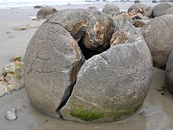
. The degree of cementation varies from being relatively weak within the interior of a boulder to quite hard within its outside rim. The outside rims of the larger boulders consist of much as 10 to 20% calcite, because the calcite not only tightly cements the silt and clay but has also replaced it to a significant degree.
The rock comprising the bulk of a boulder is riddled with large cracks called "septaria" that radiate outward from a hollow core lined with scalenohedral calcite crystals. The process or processes that created septaria within Moeraki Boulders, and in other septarian concretions, remain an unresolved matter for which a number of possible explanations have been proposed. These cracks radiate and thin outward from the centre of the typical boulder and are typically filled with an outer (early stage) layer of brown calcite and an inner (late stage) layer of yellow calcite spar, which often, but not always, completely fills the cracks. Rare Moeraki Boulders have a very thin innermost (latest stage) layer of dolomite
Dolomite
Dolomite is a carbonate mineral composed of calcium magnesium carbonate CaMg2. The term is also used to describe the sedimentary carbonate rock dolostone....
and quartz
Quartz
Quartz is the second-most-abundant mineral in the Earth's continental crust, after feldspar. It is made up of a continuous framework of SiO4 silicon–oxygen tetrahedra, with each oxygen being shared between two tetrahedra, giving an overall formula SiO2. There are many different varieties of quartz,...
covering the yellow calcite spar.
The composition of the Moeraki Boulders and the septaria that they contain are typical of, often virtually identical to, septarian concretions that have been found in exposures of sedimentary rocks in New Zealand and elsewhere. Pearson and Nelson (2005, 2006) describe in detail the occurrence of smaller but otherwise very similar septarian concretions within exposures of sedimentary rocks elsewhere in New Zealand. Similar septarian concretions have been found in the Kimmeridge Clay
Kimmeridge Clay
The Kimmeridge Clay Formation is a sedimentary deposit of fossiliferous marine clay which is of Jurassic age. It occurs in Europe.Kimmeridge Clay is arguably the most economically important unit of rocks in the whole of Europe, being the major source rock for oil fields in the North Sea hydrocarbon...
and Oxford Clay
Oxford Clay
The Oxford Clay Formation is a Jurassic marine sedimentary rock formation underlying much of southeast England, from as far west as Dorset and as far north as Yorkshire. The Oxford Clay is of middle Callovian to lower Oxfordian age and comprises 2 main facies. The lower facies comprises the...
of England
England
England is a country that is part of the United Kingdom. It shares land borders with Scotland to the north and Wales to the west; the Irish Sea is to the north west, the Celtic Sea to the south west, with the North Sea to the east and the English Channel to the south separating it from continental...
, and at many other locations worldwide.
Origin
The Moeraki Boulders are concretions created by the cementation of the PaleocenePaleocene
The Paleocene or Palaeocene, the "early recent", is a geologic epoch that lasted from about . It is the first epoch of the Palaeogene Period in the modern Cenozoic Era...
mudstone of the Moeraki
Moeraki
Moeraki is a small fishing village on the east coast of the South Island of New Zealand. It was once the location of a whaling station. In the 1870s, local interests believed it could become the main port for the north Otago area and a railway line, the Moeraki Branch, was built to the settlement...
Formation, from which they have been exhumed by coastal erosion.
The main body of the boulders started forming in what was then marine mud, near the surface of the Paleocene sea floor. This is demonstrated by studies of their composition; specifically the magnesium and iron content, and stable isotopes of oxygen and carbon. Their spherical shape indicates that the source of calcium was mass diffusion, as opposed to fluid flow.
The larger boulders, 2 metres (6.6 feet) in diameter, are estimated to have taken 4 to 5.5 million years to grow while 10 to 50 metres (33 to 165 feet) of marine mud accumulated on the seafloor above them. After the concretions formed, large cracks known as septaria formed in them. Brown calcite, yellow calcite, and small amounts of dolomite and quartz progressively filled these cracks when a drop in sea level allowed fresh groundwater to flow through the mudstone enclosing them.
Further reading
- Brunsden, D., 1969, Mystery of the Moeraki and Katiki boulders. Geographical Magazine. v. 41, n. 11, pp. 839-843.
- Klug, H., and R. Zakrzewski, R., 1986, Die Moeraki Boulders; Riesenkonkretionen am Strand auf Neuseelands Suedinsel (The Moeraki boulders; giant concretions of the beach of New Zealand's South Island) Schriften des Naturwissenschaftlichen Vereins fuer Schleswig-Holstein. v. 56, pp. 47-52
- Pearson, M.J., and C.S. Nelson, 2006, Organic chemical signatures of New Zealand carbonate concretions and calcite fracture fills as potential fluid migration indicators. in 2006 New Zealand Petroleum Conference Proceedings, Crown Minerals Group, Auckland, New Zealand.
See also
- ConcretionConcretionA concretion is a volume of sedimentary rock in which a mineral cement fills the porosity . Concretions are often ovoid or spherical in shape, although irregular shapes also occur. The word 'concretion' is derived from the Latin con meaning 'together' and crescere meaning 'to grow'...
- Rock City, KansasRock City, KansasRock City is a park located on hillsides overlooking the Solomon River in Ottawa County, Kansas. It is 3.6 miles south of Minneapolis, Kansas and just over 0.5 mile west of Kansas highway K-106 and the Minneapolis City County Airport on Ivy Road at...
- Martian spherulesMartian spherulesMartian spherules are the abundant spherical hematite inclusions discovered by the Mars rover Opportunity at Meridiani Planum on the planet Mars...
- Moqui Marbles
External links
- Moeraki Boulders
- Biek, B., 2002, Concretions and Nodules in North Dakota North Dakota Geological Survey, Bismark, North Dakota.
- Hokianga Tourism Association, nd, Koutu boulders Really nice pictures of cannonball concretions similar in size and origin to Moeraki Boulders.
- Irna, 2006, All that nature can never do, part IV : stone spheres
- Irna, 2007, Stone balls : in France too!
- Kitchens, O., nd, Moeraki Boulders a Photogallery of Pictures of Moeraki Boulders.
- Mozley, P.S., 1999, Concretions, Bombs, and Ground Water, Lite Geology, v. 14, p. 1-3 (Winter 1995)
- United States Geological Survey, nd, cannonball concretion