
Hot springs around the world
Encyclopedia
There are hot springs
on all continents and in many countries around the world. Countries that are renowned for their hot springs include, Israel
, Iceland
, New Zealand
, Chile
and Japan
, but there are interesting and unique hot springs in many other places as well.
Algeria
Egypt
Uganda
A scholarly paper with a map of over 20 geothermal areas in Uganda.
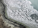
 Throughout western North America (including Alaska
) there are thousands of hot springs, many of which were created between 20 and 45 million years ago as a result of violent volcanic activity
. They range in size from the tiniest seeps to near geyser
s; from seeps like Fales Hot Ditch north of Bridgeport, California
, to subterranean lakes such as the one below Tonopah
, Arizona
, which provides natural mineral waters to the seven or more hot spring spa
s that once operated in Tonopah. The ruins of two such spas are still visible.
, some for over 10,000 years. Native Americans revered hot springs as a sacred healing place.
In Tonopah, Arizona
, it is probable that water flowed forth from the ground by itself for a few millennia. This led the local people to name the area Tonopah, meaning "Hot Water Under The Bush". Though there are no Native American ruins in the immediate vicinity of the hot springs, the presence of grain grinding mortar holes, pottery shards, and other artifacts close by to the west are a clear indication that nomadic hunter-gatherers frequented the area for many years. Additionally, hundreds of very high quality arrowhead
s have been found at or near existing springs in Tonopah, indicating that it was a popular hunting ground. This abundance of artifacts is indicative of the importance of the springs to prehistoric peoples.
Native Americans always used these natural shrines. If opposing tribes, even those at war, arrived at the same spring, all conflict ceased because they believed they were walking on sacred ground.
 Other hot or warm springs are located in:
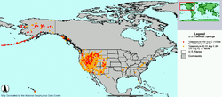
A list of 1661 hot springs in the United States can be found on the Thermal Springs List for the United States. The same list with added notes and links can be found on the USA Hotsprings Database.
claims to be home to the world's largest hot spring resort in the city of Caldas Novas
.
:
.
Costa Rica
Ecuador
Greenland
There are numerous hot springs in Greenland
:
Peru
Notes
Indonesia
uani hot spring in the south Gujarat, temperature ranging from 57 to 61 degrees C.
Japan
Being located in the "Pacific Ring of Fire
", Japan is in a volcanic region, and is home to many hot springs. The onsen
(a Japanese word for "hot spring") plays a notable role in Japanese culture. Visiting an onsen is a quintessential Japanese experience and is a popular tourist activity.
In March 2003 it was reported that there were 3,102 spa resorts in 2,292 municipalities in Japan. There were also 15,400 lodging facilities with 6,740 public hot spring baths. About 138 million people a year visit these facilities.
Famous hot springs areas in Japan
Notes
Korea
Taiwan
See Taiwanese hot springs
.
Thailand
Turkey
Vietnam
Bulgaria
Thermophylae
Hungary
Iceland
Norway
Serbia
Spain
United Kingdom
There are many geothermal springs in the UK
, but the hot springs found in the town of Bath are the only true hot springs (defined as those hotter than 37 degrees C):
There are other thermal or warm springs in the U.K and include;
Map of groundwater temperatures in Great Artesian Basin, Australia.
Fiji
Hot springs are in the town of Savusavu where local people use the hot springs to cook their food. Some of the springs are situated on the beach and steam can be seen rising from the water at low tide.
New Zealand
There are numerous hot springs in New Zealand, predominantly in the Taupo Volcanic Zone
, and in particular around Rotorua
. Well known springs outside the Taupo Volcanic Zone include The Lost Spring in Whitianga
, Coromandel Peninsula
, Hot Water Beach
, Waiwera
, and Hanmer Springs
.
United States
Hot Springs National Park
, in Hot Springs, Arkansas
was the first national park
to gain federal protection in the US. There are at least seven United States national park
s that feature hot springs:
Hot Springs
Hot Springs may refer to:* Hot Springs, Arkansas** Hot Springs National Park, Arkansas*Hot Springs, California**Hot Springs, Lassen County, California**Hot Springs, Modoc County, California**Hot Springs, Placer County, California...
on all continents and in many countries around the world. Countries that are renowned for their hot springs include, Israel
Israel
The State of Israel is a parliamentary republic located in the Middle East, along the eastern shore of the Mediterranean Sea...
, Iceland
Iceland
Iceland , described as the Republic of Iceland, is a Nordic and European island country in the North Atlantic Ocean, on the Mid-Atlantic Ridge. Iceland also refers to the main island of the country, which contains almost all the population and almost all the land area. The country has a population...
, New Zealand
New Zealand
New Zealand is an island country in the south-western Pacific Ocean comprising two main landmasses and numerous smaller islands. The country is situated some east of Australia across the Tasman Sea, and roughly south of the Pacific island nations of New Caledonia, Fiji, and Tonga...
, Chile
Chile
Chile ,officially the Republic of Chile , is a country in South America occupying a long, narrow coastal strip between the Andes mountains to the east and the Pacific Ocean to the west. It borders Peru to the north, Bolivia to the northeast, Argentina to the east, and the Drake Passage in the far...
and Japan
Japan
Japan is an island nation in East Asia. Located in the Pacific Ocean, it lies to the east of the Sea of Japan, China, North Korea, South Korea and Russia, stretching from the Sea of Okhotsk in the north to the East China Sea and Taiwan in the south...
, but there are interesting and unique hot springs in many other places as well.
AlgeriaAlgeriaAlgeria , officially the People's Democratic Republic of Algeria , also formally referred to as the Democratic and Popular Republic of Algeria, is a country in the Maghreb region of Northwest Africa with Algiers as its capital.In terms of land area, it is the largest country in Africa and the Arab...
- Hammam Essalihine (Thermes de Flavius)
- Hammam Chellala (Thermes Chellala)
- Hammam Guedjima (Thermes Guedjima)
- N'GaousN'GaousN'Gaous is a town in northeastern Algeria....
(Source de Saïda) - GuelmaGuelmaGuelma is the capital of Guelma Province and Guelma District, located in northeastern Algeria, about 65 kilometers from the Mediterranean coast...
(Source de Guelma)
EgyptEgyptEgypt , officially the Arab Republic of Egypt, Arabic: , is a country mainly in North Africa, with the Sinai Peninsula forming a land bridge in Southwest Asia. Egypt is thus a transcontinental country, and a major power in Africa, the Mediterranean Basin, the Middle East and the Muslim world...
- Oyoun Mossa (Moses Springs)
- Hammam pharaon (Pharaoh Bath)
- Hammam Musa (Moses' Bath)
UgandaUgandaUganda , officially the Republic of Uganda, is a landlocked country in East Africa. Uganda is also known as the "Pearl of Africa". It is bordered on the east by Kenya, on the north by South Sudan, on the west by the Democratic Republic of the Congo, on the southwest by Rwanda, and on the south by...
- Ihimba Hot SpringsIhimba Hot SpringsThe Ihimba hot springs are situated on Kabale-Katuna Road, approximately , south of Kabale. The Ihimba hot springs derive their name from the Bahimba people who live near these springs....
- Kitagata Hot SpringsKitagata Hot Springs-Location:The hot springs are located in Sheema County, Sheema District, Western Uganda. This location is approximately , by road, east of Kitagata, one of the urban centers in the district. This location lies approximately , by road, west of Mbarara, the largest city in the sub-region...
- Nyamasizi Hot Springs
- Semliki Hot Springs
- Buranga hot springs
A scholarly paper with a map of over 20 geothermal areas in Uganda.
Americas
Alaska
Alaska is the largest state in the United States by area. It is situated in the northwest extremity of the North American continent, with Canada to the east, the Arctic Ocean to the north, and the Pacific Ocean to the west and south, with Russia further west across the Bering Strait...
) there are thousands of hot springs, many of which were created between 20 and 45 million years ago as a result of violent volcanic activity
Volcanism
Volcanism is the phenomenon connected with volcanoes and volcanic activity. It includes all phenomena resulting from and causing magma within the crust or mantle of a planet to rise through the crust and form volcanic rocks on the surface....
. They range in size from the tiniest seeps to near geyser
Geyser
A geyser is a spring characterized by intermittent discharge of water ejected turbulently and accompanied by a vapour phase . The word geyser comes from Geysir, the name of an erupting spring at Haukadalur, Iceland; that name, in turn, comes from the Icelandic verb geysa, "to gush", the verb...
s; from seeps like Fales Hot Ditch north of Bridgeport, California
Bridgeport, California
Bridgeport is a census-designated place that is the county seat of Mono County, California. It lies at an elevation of 6463 feet in the middle of the Bridgeport Valley. Bridgeport is located at the intersection of highways US 395 and State Route 182. The population was 575 at the 2010...
, to subterranean lakes such as the one below Tonopah
Tonopah, Arizona
Tonopah is a census-designated place in western Maricopa County, Arizona, United States, approximately 50 miles west of downtown Phoenix off Interstate 10...
, Arizona
Tonopah Desert
The Tonopah Desert is a small desert plains region west of Phoenix, Arizona. It is adjacent north of Interstate 10 and lies at the southwest intersection of the Hassayampa River with the Gila River...
, which provides natural mineral waters to the seven or more hot spring spa
Spa
The term spa is associated with water treatment which is also known as balneotherapy. Spa towns or spa resorts typically offer various health treatments. The belief in the curative powers of mineral waters goes back to prehistoric times. Such practices have been popular worldwide, but are...
s that once operated in Tonopah. The ruins of two such spas are still visible.
Native Americans and hot springs
Every major hot spring in North America and South America has some record of use by Native AmericansIndigenous peoples of the Americas
The indigenous peoples of the Americas are the pre-Columbian inhabitants of North and South America, their descendants and other ethnic groups who are identified with those peoples. Indigenous peoples are known in Canada as Aboriginal peoples, and in the United States as Native Americans...
, some for over 10,000 years. Native Americans revered hot springs as a sacred healing place.
In Tonopah, Arizona
Tonopah, Arizona
Tonopah is a census-designated place in western Maricopa County, Arizona, United States, approximately 50 miles west of downtown Phoenix off Interstate 10...
, it is probable that water flowed forth from the ground by itself for a few millennia. This led the local people to name the area Tonopah, meaning "Hot Water Under The Bush". Though there are no Native American ruins in the immediate vicinity of the hot springs, the presence of grain grinding mortar holes, pottery shards, and other artifacts close by to the west are a clear indication that nomadic hunter-gatherers frequented the area for many years. Additionally, hundreds of very high quality arrowhead
Arrowhead
An arrowhead is a tip, usually sharpened, added to an arrow to make it more deadly or to fulfill some special purpose. Historically arrowheads were made of stone and of organic materials; as human civilization progressed other materials were used...
s have been found at or near existing springs in Tonopah, indicating that it was a popular hunting ground. This abundance of artifacts is indicative of the importance of the springs to prehistoric peoples.
Native Americans always used these natural shrines. If opposing tribes, even those at war, arrived at the same spring, all conflict ceased because they believed they were walking on sacred ground.
United States
- AlaskaAlaskaAlaska is the largest state in the United States by area. It is situated in the northwest extremity of the North American continent, with Canada to the east, the Arctic Ocean to the north, and the Pacific Ocean to the west and south, with Russia further west across the Bering Strait...
- Baranof Warm Springs
- Chena Hot Springs
- Circle Hot Springs
- Tolovana Hot SpringsTolovana Hot SpringsLocated south of the Elliott Highway in interior Alaska, Tolovana Hot Springs is the most remote of the "big 4" hot springs in the region. A private air strip has recently been cleared, and there is no road access...
- Manley Hot Springs
- ArizonaArizonaArizona ; is a state located in the southwestern region of the United States. It is also part of the western United States and the mountain west. The capital and largest city is Phoenix...
- TonopahTonopah, ArizonaTonopah is a census-designated place in western Maricopa County, Arizona, United States, approximately 50 miles west of downtown Phoenix off Interstate 10...
- Verde Hot Springs Childs, AZ
- Tonopah
- ArkansasArkansasArkansas is a state located in the southern region of the United States. Its name is an Algonquian name of the Quapaw Indians. Arkansas shares borders with six states , and its eastern border is largely defined by the Mississippi River...
- Hot SpringsHot Springs, ArkansasHot Springs is the 10th most populous city in the U.S. state of Arkansas, the county seat of Garland County, and the principal city of the Hot Springs Metropolitan Statistical Area encompassing all of Garland County...
- Hot Springs
- CaliforniaCaliforniaCalifornia is a state located on the West Coast of the United States. It is by far the most populous U.S. state, and the third-largest by land area...
- Big Bend Hot Springs
- CalistogaCalistoga, CaliforniaCalistoga is a city in Napa County, California, United States. The population was 5,155 at the 2010 census.-Geography:According to the United States Census Bureau, the city has a total area of , 99.30% of it land and 0.70% of it water.-Climate:...
- Crabtree Hot SpringsCrabtree Hot Springs, CaliforniaCrabtree Hot Springs is an unincorporated community and geological phenomenon in Lake County, California about north of Upper Lake. It lies at an elevation of 2,257 feet...
- Desert Hot SpringsDesert Hot Springs, CaliforniaDesert Hot Springs, also known as DHS, is a city in Riverside County, California, United States. The city is located within the Coachella Valley geographic region, sometimes referred to as the Desert Empire. The population was 25,938 at the 2010 census, up from 16,582 at the 2000 United States...
- Deep Creek Hot SpringsDeep Creek Hot SpringsDeep Creek Hot Springs, DCHS, are natural hot springs located in the northern Mojave Desert section of the San Bernardino National Forest, near Hesperia in San Bernardino County, Southern California.-Geography:...
- Delonga Hot Springs
- EsalenEsalen InstituteEsalen Institute is a residential community and retreat in Big Sur, California, which focuses upon humanistic alternative education. Esalen is a nonprofit organization devoted to activites such as meditation, massage, Gestalt, yoga, psychology, ecology, and spirituality...
in Big SurBig SurBig Sur is a sparsely populated region of the Central Coast of California where the Santa Lucia Mountains rise abruptly from the Pacific Ocean. The name "Big Sur" is derived from the original Spanish-language "el sur grande", meaning "the big south", or from "el país grande del sur", "the big... - Gilroy Yamato Hot SpringsGilroy Yamato Hot SpringsGilroy Yamato Hot Springs, a California Historical Landmark and on the list of National Register of Historical Places, is a property near Gilroy, California famed for its mineral hot springs and historic development by early settlers and Japanese immigrants. The earliest extant Italianate–Victorian...
- Grover Hot Springs State ParkGrover Hot Springs State ParkGrover Hot Springs State Park is a state park in eastern California, USA that was sold to the Parks and Recreation Department in the 60's. Accessed from Markleeville...
- Harbin Hot SpringsHarbin Hot SpringsHarbin Hot Springs is a non-profit hot spring retreat and workshop center in Harbin Springs, Lake County, in Northern California, about two hours northeast of the San Francisco Bay Area.-History:...
in MiddletownMiddletown, CaliforniaMiddletown is a census-designated place in Lake County, California, United States. Middletown is located south of Lower Lake, at an elevation of 1099 feet . The population was 1,323 at the 2010 census, up from 1,020 at the 2000 census... - Keough Hot SpringsKeough Hot SpringsKeough Hot Springs is located in the Owens Valley of California, about seven miles south of the city of Bishop on US Highway 395.-History:The area around this hot springs was originally inhabited by the local native Paiutes, who considered the waters sacred...
- Mercey Hot Springs
- Miracle Hot Springs
- Mono Hot Springs
- Murrieta Hot SpringsMurrieta Hot Springs, CaliforniaMurrieta Hot Springs is a former census-designated place in Riverside County, California, United States. The population was 2,948 at the 2000 census...
- Palm SpringsPalm Springs, CaliforniaPalm Springs is a desert city in Riverside County, California, within the Coachella Valley. It is located approximately 37 miles east of San Bernardino, 111 miles east of Los Angeles and 136 miles northeast of San Diego...
- Remington Hot Springs
- Travertine Hot springsBridgeport, CaliforniaBridgeport is a census-designated place that is the county seat of Mono County, California. It lies at an elevation of 6463 feet in the middle of the Bridgeport Valley. Bridgeport is located at the intersection of highways US 395 and State Route 182. The population was 575 at the 2010...
- Sespe Hot Springs
- Warner Springs
- Wilbur Hot SpringsWilbur Hot SpringsWilbur Hot Springs is a naturally occurring historic hot spring, health sanctuary, personal retreat and nature preserve in Williams, California, in Colusa County, California in northern California, USA, about 2 hours northeast of the San Francisco Bay Area, 1½ hours north of the Sacramento...
in Colusa County, CaliforniaCaliforniaCalifornia is a state located on the West Coast of the United States. It is by far the most populous U.S. state, and the third-largest by land area...
- ColoradoColoradoColorado is a U.S. state that encompasses much of the Rocky Mountains as well as the northeastern portion of the Colorado Plateau and the western edge of the Great Plains...
- Glenwood SpringsGlenwood Springs, ColoradoThe City of Glenwood Springs is a Home Rule Municipality that is the county seat and the most populous city of Garfield County, Colorado, United States. The United States Census Bureau estimated that the city population was 8,564 in 2005...
- OurayOuray, ColoradoThe historic City of Ouray is a Home Rule Municipality that is the county seat and the most populous city of Ouray County, Colorado, United States. The city population was 813 at the U.S. Census 2000 and 1,000 as of the U.S. Census 2010...
- Pagosa SpringsPagosa Springs, ColoradoPagosa Springs is a Home Rule Municipality that is the county seat of, and the only incorporated municipality in, Archuleta County, Colorado, United States. The population was 1,591 at the 2000 census...
- Glenwood Springs
- FloridaFloridaFlorida is a state in the southeastern United States, located on the nation's Atlantic and Gulf coasts. It is bordered to the west by the Gulf of Mexico, to the north by Alabama and Georgia and to the east by the Atlantic Ocean. With a population of 18,801,310 as measured by the 2010 census, it...
- Silver SpringsSilver Springs, FloridaSilver Springs is a U.S. populated place and spring in Marion County, Florida, just to the east of the city of Ocala. It is part of the Ocala Metropolitan Statistical Area....
- Silver Springs
- GeorgiaGeorgia (U.S. state)Georgia is a state located in the southeastern United States. It was established in 1732, the last of the original Thirteen Colonies. The state is named after King George II of Great Britain. Georgia was the fourth state to ratify the United States Constitution, on January 2, 1788...
- Radium SpringsRadium Springs, GeorgiaRadium Springs is an unincorporated community located on the southeast outskirts of Albany in Dougherty County, Georgia, United States. It is part of the Albany, Georgia Metropolitan Statistical Area....
(20 degrees C, 68 degrees F) - Warm SpringsWarm Springs, GeorgiaWarm Springs is a city in Meriwether County, Georgia, United States. The population was 478 at the 2010 census.-History:Warm Springs first came to prominence in the 19th century as a spa town, due to its mineral springs which flow constantly at nearly 32 °C...
(90 degrees F)
- Radium Springs
- IdahoIdahoIdaho is a state in the Rocky Mountain area of the United States. The state's largest city and capital is Boise. Residents are called "Idahoans". Idaho was admitted to the Union on July 3, 1890, as the 43rd state....
- Lava Hot SpringsLava Hot Springs, IdahoLava Hot Springs is a city in Bannock County, Idaho, United States. It is part of the 'Pocatello, Idaho Metropolitan Statistical Area'. The population was 521 at the 2000 census...
- Stanley Hot SpringsStanley Hot Springs, IdahoStanley Hot Springs is a series of primitive soaking pools located in the Selway-Bitterroot Wilderness. Located in beautiful country and access via Trail # 211 is just hard enough that there are not an exorbitant number of people.-Driving Directions:...
- Silver Crick Plunge, Idaho
- Green Canyon Hot Springs, Idaho
- Heise Hot Springs Ririe, Idaho (28 degrees C, 82 degrees F)
- Lava Hot Springs
- IllinoisIllinoisIllinois is the fifth-most populous state of the United States of America, and is often noted for being a microcosm of the entire country. With Chicago in the northeast, small industrial cities and great agricultural productivity in central and northern Illinois, and natural resources like coal,...
- Little Hot Springs of IllinoisOkawville, IllinoisOkawville is a village in Washington County, Illinois, United States. The population was 1,434 at the 2010 census.-Geography:Okawville is located at...
- Little Hot Springs of Illinois
- MontanaMontanaMontana is a state in the Western United States. The western third of Montana contains numerous mountain ranges. Smaller, "island ranges" are found in the central third of the state, for a total of 77 named ranges of the Rocky Mountains. This geographical fact is reflected in the state's name,...
- Hot SpringsHot Springs, MontanaHot Springs is a town on the Flathead Indian Reservation in Sanders County, Montana, United States. The population was 531 at the 2000 census. Founded in 1910, it was incorporated in 1929.-Geography:Hot Springs is located at ....
- Hot Springs
- New MexicoNew MexicoNew Mexico is a state located in the southwest and western regions of the United States. New Mexico is also usually considered one of the Mountain States. With a population density of 16 per square mile, New Mexico is the sixth-most sparsely inhabited U.S...
- Truth or ConsequencesTruth or Consequences, New MexicoTruth or Consequences is a spa city and the county seat of Sierra County, New Mexico, United States. As of the 2000 census, the population was 7,289. It is commonly known within New Mexico as T or C....
- Middle Fork Hot Springs, Gila National ForestGila National ForestThe Gila National Forest is a protected national forest in New Mexico in the southwestern United States established in 1905. It covers approximately 3.3 million acres of public land, making it the sixth largest National Forest in the continental United States...
- Jordan Hot Springs, Gila National ForestGila National ForestThe Gila National Forest is a protected national forest in New Mexico in the southwestern United States established in 1905. It covers approximately 3.3 million acres of public land, making it the sixth largest National Forest in the continental United States...
- Turkey Creek Hot Springs, Gila National ForestGila National ForestThe Gila National Forest is a protected national forest in New Mexico in the southwestern United States established in 1905. It covers approximately 3.3 million acres of public land, making it the sixth largest National Forest in the continental United States...
- Hot Springs on Hot Springs Boulevard, Montezuma, New MexicoMontezuma, New MexicoMontezuma is an unincorporated community in San Miguel County, New Mexico, United States. It is located about five miles northwest of the city of Las Vegas, New Mexico....
- Truth or Consequences
- New YorkNew YorkNew York is a state in the Northeastern region of the United States. It is the nation's third most populous state. New York is bordered by New Jersey and Pennsylvania to the south, and by Connecticut, Massachusetts and Vermont to the east...
- Lebanon Springs
- North CarolinaNorth CarolinaNorth Carolina is a state located in the southeastern United States. The state borders South Carolina and Georgia to the south, Tennessee to the west and Virginia to the north. North Carolina contains 100 counties. Its capital is Raleigh, and its largest city is Charlotte...
- Hot SpringsHot Springs, North CarolinaHot Springs is a town in Madison County, North Carolina, United States. The population was 645 at the 2000 census. It is part of the Asheville Metropolitan Statistical Area.-Geography:Hot Springs is located at ....
- Hot Springs
- OregonOregonOregon is a state in the Pacific Northwest region of the United States. It is located on the Pacific coast, with Washington to the north, California to the south, Nevada on the southeast and Idaho to the east. The Columbia and Snake rivers delineate much of Oregon's northern and eastern...
- Alvord Hot SpringsAlvord Hot SpringsAlvord Hot Springs is a geothermal spring located near the southeastern corner of the state of Oregon in the United States.-Geography:The spring lies at 4080 ft elevation on the western edge of the Alvord Desert into which the spring flows and eventually evaporates...
- Antelope Hot SpringsAntelope Hot SpringsAntelope Hot Springs are natural hot springs located in southeastern Oregon, U.S. northeast of Lakeview and northeast of the community of Plush, a drive....
- Bagby Hot SpringsBagby Hot SpringsThe Bagby Hot Springs are natural hot springs located in the Mount Hood National Forest about southeast of Portland, Oregon, United States and about east of Salem, Oregon. The springs are within the Cascade Mountains in a heavily forested area at elevation 2280 ft...
- Belknap Hot Springs
- Breitenbush Hot Springs
- Cougar Hot SpringsCougar Hot SpringsCougar Hot Springs, officially known as Terwilliger Hot Springs, are geothermal pools located in the Willamette National Forest in the U.S. state of Oregon, 53 miles east of Eugene. The springs drain into Rider Creek, which in turn drains into Cougar Reservoir. They are located about a quarter mile...
- Deer Creek Hot Springs
- Hot Lake SpringsHot Lake, OregonHot Lake is an unincorporated community in Union County, Oregon, United States. Hot Lake has an elevation of 2703 feet . It is located about ten miles east of La Grande, and seven miles northwest of Union....
- Hunter's Hot SpringHunter's Hot Springs (Oregon)Hunter's Hot Springs are natural geothermal springs located in Lake County, Oregon, United States, two miles north of Lakeview. The springs are named after Harry Hunter, who bought the springs in 1923. The best known feature within the geothermal area is Old Perpetual, which was once Oregon's...
- McCreedy Hot Springs
- Mickey Hot SpringsMickey Hot SpringsMickey Hot Springs is a small hot spring system at the north end of Alvord Desert just east of Steens Mountain in southeastern Oregon, United States. There are several natural bubbling mudpots and steam vents. The system contains at least 60 vents, 11 of which are dry...
- Umpqua Hot SpringsUmpqua Hot SpringsThe Umpqua Hot Springs are geothermal pools located along the Umpqua River in the U.S. state of Oregon at elevation. Two oval pools available for soaking, the larger having a solid rock bottom and the smaller a bottom of coarse sand. The larger is five by eight feet and , and is covered by a...
- Alvord Hot Springs
- South DakotaSouth DakotaSouth Dakota is a state located in the Midwestern region of the United States. It is named after the Lakota and Dakota Sioux American Indian tribes. Once a part of Dakota Territory, South Dakota became a state on November 2, 1889. The state has an area of and an estimated population of just over...
- Hot SpringsHot Springs, South DakotaHot Springs is a city in Fall River County, South Dakota, United States. As of the 2010 census, the city population was 3,711. It is the county seat of Fall River County...
- Hot Springs
- UtahUtahUtah is a state in the Western United States. It was the 45th state to join the Union, on January 4, 1896. Approximately 80% of Utah's 2,763,885 people live along the Wasatch Front, centering on Salt Lake City. This leaves vast expanses of the state nearly uninhabited, making the population the...
- Crystal Hot Springs, Honeyville
- Pa Tempe Hot Springs, La Verkin
- MeadowMeadow, UtahMeadow is a town in Millard County, Utah, United States. The population was 254 at the 2000 census. Originally called Meadow Creek, the town is located about eight miles south of Fillmore.-History:The Meadow Creek was the site where Walkara died in 1855...
- Homestead, Midway
- Mystic Hot Springs, Monroe
- VirginiaVirginiaThe Commonwealth of Virginia , is a U.S. state on the Atlantic Coast of the Southern United States. Virginia is nicknamed the "Old Dominion" and sometimes the "Mother of Presidents" after the eight U.S. presidents born there...
- Warm SpringsWarm Springs, VirginiaWarm Springs is a census-designated place in and the county seat of Bath County, Virginia, United States. The population as of the 2010 Census was 123. It lies along U.S. Route 220 near the center of the county.-History and geography:...
- Hot SpringsHot Springs, VirginiaHot Springs is a census-designated place in Bath County, Virginia, United States. The population as of the 2010 Census was 738. It is located about 5 miles southwest of Warm Springs on U.S. Route 220. Hot Springs is the site of a number of resorts that make use of the springs.The area is...
- Warm Springs
- Washington
- Olympic Hot SpringsOlympic Hot SpringsOlympic Hot Springs is located in Olympic National Park, Washington, United States. The springs contain 21 seeps near Boulder Creek, a tributary of the Elwha River. The temperature varies from lukewarm to 138 degrees.-History:...
- Scenic Hot SpringsScenic Hot SpringsScenic Hot Springs is a natural hot spring in Washington. Located on a high steep northwestern slope, it is located to the south of US Route 2 about 8 miles west of Stevens Pass, and bordering the Alpine Lakes Wilderness...
- Sol Duc Hot SpringsSol Duc Hot SpringsSol Duc Hot Springs is a resort located in Olympic National Park that is best known for its soaking pools, hot tubs, and a swimming pool that are heated with the nearby hot springs. The resort is situated in a valley carved by the Sol Duc River....
- Olympic Hot Springs
- WyomingWyomingWyoming is a state in the mountain region of the Western United States. The western two thirds of the state is covered mostly with the mountain ranges and rangelands in the foothills of the Eastern Rocky Mountains, while the eastern third of the state is high elevation prairie known as the High...
- Boiling River, Yellowstone National Park
- SaratogaSaratoga, WyomingSaratoga is a town in Carbon County, Wyoming, United States. The population was 1,736 at the 2000 census.Saratoga is the home of the Steinley Cup microbrew competition, usually held in August at Veterans Island Park, a playground and picnic facility located on a small island in the North Platte...
- Hot Springs State ParkHot Springs State ParkHot Springs State Park is a park in Thermopolis, Wyoming famous for its hot springs. It was Wyoming's first state park.The park includes a number of businesses:*Wyoming Pioneer Home, a state-run assisted-living facility*Gottsche Rehabilitation Center...
in ThermopolisThermopolis, WyomingThermopolis is the largest town in, and the county seat of Hot Springs County, Wyoming, United States. As of the 2000 census, the town population was 3,172....
A list of 1661 hot springs in the United States can be found on the Thermal Springs List for the United States. The same list with added notes and links can be found on the USA Hotsprings Database.
México
- Aguascalientes; Aguascalientes
- Tlacotlapilco; Hidalgo
- Los Azufres; Michoacán
- Abasolo; Guanajuato
- Imala; Sinaloa
Brazil
BrazilBrazil
Brazil , officially the Federative Republic of Brazil , is the largest country in South America. It is the world's fifth largest country, both by geographical area and by population with over 192 million people...
claims to be home to the world's largest hot spring resort in the city of Caldas Novas
Caldas Novas
Caldas Novas is a Brazilian city and municipality in the state of Goiás. It is considered by many to be the largest hydro-thermal resort in the world.-Location:...
.
Canada
There are hot springs throughout Canada, particularly in the far west. Here are some prominent hot springs located in Western CanadaWestern Canada
Western Canada, also referred to as the Western provinces and commonly as the West, is a region of Canada that includes the four provinces west of the province of Ontario.- Provinces :...
:
- AlbertaAlbertaAlberta is a province of Canada. It had an estimated population of 3.7 million in 2010 making it the most populous of Canada's three prairie provinces...
- Banff Upper Hot Springs, aka Banff Springs, near the Town of BanffBanff, AlbertaBanff is a town within Banff National Park in Alberta, Canada. It is located in Alberta's Rockies along the Trans-Canada Highway, approximately west of Calgary and east of Lake Louise....
- Miette Hot Springs, near Jasper, AlbertaJasper, AlbertaJasper is a specialized municipality in western Alberta, Canada. It is the commercial centre of Jasper National Park, located in the Canadian Rockies in the Athabasca River valley....
- Banff Upper Hot Springs, aka Banff Springs, near the Town of Banff
- British ColumbiaBritish ColumbiaBritish Columbia is the westernmost of Canada's provinces and is known for its natural beauty, as reflected in its Latin motto, Splendor sine occasu . Its name was chosen by Queen Victoria in 1858...
- Ahousat Hot Springs, Ahousat (Gibson Marine Provincial ParkGibson Marine Provincial ParkGibson Marine Provincial Park is a provincial park in British Columbia, Canada, located on the southeast end of Flores Island in the central Clayoquot Sound region of Vancouver Island, British Columbia, Canada...
) - Ainsworth Hot SpringsAinsworth, British ColumbiaAinsworth or Ainsworth Hot Springs is a historic village on Kootenay Lake in British Columbia, Canada and has a population of 50.Founded on May 31, 1883, it is the oldest surviving community on Kootenay Lake....
& Cody CavesCody CavesThe Cody Caves are a network of limestone caves in the Selkirk Mountains in British Columbia, Canada. They are located north of Ainsworth Hot Springs on the west side of Kootenay Lake....
, Ainsworth, British Columbia - Canyon Hot SpringsAlbert Canyon, British ColumbiaAlbert Canyon was a railway-based village in the Rogers Pass area of British Columbia, Canada, based around a hot spring known as Canyon Hot Springs and also a "pusher" station for pass-climbing engines of the Canadian Pacific Railway...
(Albert Canyon, near RevelstokeRevelstoke, British ColumbiaRevelstoke is a city in southeastern British Columbia, Canada. It is located east of Vancouver, and west of Calgary, Alberta. The city is situated on the banks of the Columbia River just south of the Revelstoke Dam and near its confluence with the Illecillewaet River...
) - Bishop Bay Hot Springs, in Devastation Channel, 80 km south of KitimatKitimat, British ColumbiaKitimat is a coastal city in northwestern British Columbia, in the Regional District of Kitimat-Stikine. The Kitimat Valley, which includes the adjacent community of Terrace, is the most populous urban district in Northwest British Columbia...
(North Coast) - Stikine Hot SpringsChoquette Hot Springs Provincial ParkChoquette Hot Springs Provincial Park is a provincial park in the Stikine Country region of northwestern British Columbia, Canada. Despite the park's name, the official and most commonly used name of the springs it was established to protect is Stikine River Hot Springs...
(Choquette Hot Springs Provincial ParkChoquette Hot Springs Provincial ParkChoquette Hot Springs Provincial Park is a provincial park in the Stikine Country region of northwestern British Columbia, Canada. Despite the park's name, the official and most commonly used name of the springs it was established to protect is Stikine River Hot Springs...
) - Fairmont Hot Springs, InvermereInvermere, British ColumbiaInvermere is a community in eastern British Columbia, Canada, near the border of Alberta. With its growing permanent population of almost 4,000 , swelling to near 40,000 on summer weekends, it is the hub of the Columbia Valley between Golden, and Cranbrook...
- Dewar Hot Springs, Purcell MountainsPurcell MountainsThe Purcell Mountains are a mountain range in southeastern British Columbia, Canada. They are a subrange of the Columbia Mountains, which includes the Selkirk, Monashee, and Cariboo Mountains. They are located on the west side of the Rocky Mountain Trench in the area of the Columbia Valley, and on...
- Frizzell HotspringsFrizzell HotspringsFrizzell Hotsprings is a hot spring on the south bank of the Skeena River, northeast of Hotspring Point, near Prince Rupert, British Columbia, Canada....
, lower Skeena RiverSkeena RiverThe Skeena River is the second longest river entirely within British Columbia, Canada . The Skeena is an important transportation artery, particularly for the Tsimshian and the Gitxsan - whose names mean "inside the Skeena River" and "people of the Skeena River" respectively, and also during the... - Harrison Hot Springs, north of AgassizAgassiz, British ColumbiaAgassiz is a small community located in British Columbia's Fraser Valley. The only town within the jurisdiction of the District Municipality of Kent, it contains the majority of Kent's population.-References:...
- Hot Springs Cove, near Ahousat
- Hotspring IslandHotspring IslandHotspring Island, originally named in English as Volcanic Island and known in the Haida language as G̱andll K'in Gwaayaay , is a small island near the southeast coast of Lyell Island in the Queen Charlotte Islands archipelago of the North Coast of British Columbia, Canada...
, Queen Charlotte IslandsQueen Charlotte IslandsHaida Gwaii , formerly the Queen Charlotte Islands, is an archipelago on the North Coast of British Columbia, Canada. Haida Gwaii consists of two main islands: Graham Island in the north, and Moresby Island in the south, along with approximately 150 smaller islands with a total landmass of... - Iskut River Hot SpringsIskut River Hot Springs Provincial ParkIskut River Hot Springs Provincial Park is a small provincial park in British Columbia, Canada, located on the western side of the Iskut River....
- Lakelse Hot SpringsLakelse Hot SpringsThe Lakese Hot Springs, also known as the Mount Layton Hot Springs, are a group of hot springs in the Kalum-Kitimat valley of northern British Columbia, Canada, located on the eastern shore of Lakelse Lake in Lakelse Lake Provincial Park south of Terrace along Highway 37...
, TerraceTerrace, British ColumbiaTerrace is a city on the Skeena River in British Columbia, Canada. The Kitselas people, a tribe of the Tsimshian Nation, have lived in the Terrace area for thousands of years. The community population fell between 2001 and 2006 from 12,109 with a regional population of 19,980 to 11,320 and... - Lussier Hot SpringsLussier Hot SpringsLussier Hot Springs is a quaint and undeveloped hot spring just inside Whiteswan Lake Provincial Park in British Columbia, a province of Canada.- Access :...
(Whiteswan Lake Provincial ParkWhiteswan Lake Provincial ParkWhiteswan Lake Provincial Park is a provincial park in British Columbia, Canada, located in the Kootenay Ranges of the Rocky Mountains, 22 km east of Canal Flats.- Access :...
) - Liard River Hot SpringsLiard River Hot Springs Provincial ParkLiard River Hot Springs Provincial Park is a provincial park in British Columbia, Canada. It is home to the second largest hot spring in Canada. The park is part of the larger Muskwa-Kechika Management Area. The community of Liard River, British Columbia is located nearby.-History and...
- Meager Creek Hot Springs and Mount MeagerMount MeagerMount Meager, originally known as Meager Mountain, is a complex volcano in the Sea-to-Sky Corridor of southwestern British Columbia, Canada. It is located north of Vancouver at the northern end of the Pemberton Valley. Part of the Cascade Volcanic Arc of western North America, its summit is above...
, northwest of PembertonPemberton, British ColumbiaPemberton is a village north of Whistler in the Pemberton Valley of British Columbia in Canada, with a population of 2,192. Until the 1960s the village could be accessed only by train but that changed when Highway 99 was built through Whistler and Pemberton.-Climate:The climate of Pemberton is... - Mount Cayley Hot SpringsMount CayleyMount Cayley is a potentially active stratovolcano in Squamish-Lillooet Regional District of southwestern British Columbia, Canada. Located north of Squamish and west of Whistler in the Pacific Ranges of the Coast Mountains, it rises above the Squamish River to the west and above the Cheakamus...
- Brandywine Creek Hot SpringsBrandywine Creek (British Columbia)Brandywine Creek, also formerly known as the Long John River after a local prospector and trapper, is a tributary of the Cheakamus River in the Pacific Ranges of the Coast Mountains in British Columbia, Canada, entering that stream via Daisy Lake, just below Brandywine Falls...
- Mount Layton Hot Springs, near Kitimat
- Nascall Hot Springs, Dean ChannelDean ChannelDean Channel is the upper end of one of the longest inlets of the British Columbia Coast, from its head at the mouth of the Kimsquit River. The Dean River, one of the main rivers of the Coast Mountains, enters Dean Channel about below the head of the inlet, at the community of...
- Vicinity of Nakusp/Arrow Lakes:
- Coyote Springs
- Halcyon Hot Springs
- Halfway RiverHalfway RiverHalfway River is a river in north-eastern British Columbia, Canada. It is a major tributary of the Peace River.The river originates in the Muskwa Ranges at an elevation of . It flows from Robb Lake, between Mount Kenny and Mount Robb, then flows east to Pink Mountain...
- Nakusp Hot Springs
- Octopus Creek
- Saint Leon Hot Springs
- Upper Halfway River
- Wilson Lake
- Prophet River Hot SpringsProphet River Hotsprings Provincial ParkProphet River Hotsprings Provincial Park is a provincial park in British Columbia, Canada. Established high in the Muskwa Ranges, on the course of the Prophet River, it is part of the larger Muskwa-Kechika Management Area.-See also:...
, Alaska HighwayAlaska HighwayThe Alaska Highway was constructed during World War II for the purpose of connecting the contiguous U.S. to Alaska through Canada. It begins at the junction with several Canadian highways in Dawson Creek, British Columbia and runs to Delta Junction, Alaska, via Whitehorse, Yukon... - Radium Hot SpringsRadium Hot Springs, British ColumbiaRadium Hot Springs is a village of approximately 800 people situated in the East Kootenay region of British Columbia. The village is named for the hot springs located in the nearby Kootenay National Park...
, Columbia ValleyColumbia ValleyThe Columbia Valley is the name used for a region in the Rocky Mountain Trench near the headwaters of the Columbia River between the town of Golden and the Canal Flats. The main hub of the valley is the town of Invermere. Other towns include Radium Hot Springs, Windermere and Fairmont Hot Springs... - Ram Creek Hot Springs, SkookumchuckSkookumchuck, British ColumbiaSkookumchuck is a Canadian town in the East Kootenay region of the province of British Columbia, along British Columbia highway 93/95 at the junction of the Kootenay and Lussier Rivers.-Industry:...
- Shearwater Hot Springs, south of Kitimat, North Coast
- Sherwin Hot Springs, west side of Kootenay Lake, north of Ainsworth Hot Springs
- Ramsay Hot SpringsRamsay Hot SpringsRamsay Hot Springs is a hot spring in the western Clayoquot Sound region of the West Coast of Vancouver Island, British Columbia, Canada, located north of Sharp Point to the west of Sydney Inlet. The hot springs are the namesake of the community and cove of Hot Springs Cove and are protected by...
, (Maquinna Marine Provincial ParkMaquinna Marine Provincial ParkMaquinna Marine Provincial Park is a provincial park in British Columbia, Canada, located northwest of Tofino in the Clayoquot Sound region of the West Coast of Vancouver Island, protecting Ramsay Hot Springs, which is the name-source of the cove, settlement and former post office of Hot Springs...
) - Sloquet Creek Hot Springs, near Port DouglasPort Douglas, British ColumbiaPort Douglas, sometimes referred to simply as Douglas, is a remote community in British Columbia, Canada at the head of Harrison Lake, which is the head of river navigation from the Strait of Georgia...
- Skookumchuck Hot SpringsSkookumchuck Hot Springs, British ColumbiaT'sek Hot Springs, near the First Nation community of Skookumchuck and more recently as Skatin is on the historic Harrison Lillooet Gold Rush trail in the Lillooet River valley, south of Lillooet Lake, in British Columbia, Canada...
(St. Agnes' Well), between Pemberton and Port Douglas - Tallheo Hot Springs, South Bentinck Arm
- Toad River Hot SpringsToad River Hot Springs Provincial ParkToad River Hot Springs Provincial Park is a provincial park in British Columbia, Canada. The hotsprings is located on the lefthand bank of the Toad River, outside of the Racing River outflow. Access is via hiking, river boat, horseback, or helicopter. There is no actual bathing pool, so visitors...
, Alaska HighwayAlaska HighwayThe Alaska Highway was constructed during World War II for the purpose of connecting the contiguous U.S. to Alaska through Canada. It begins at the junction with several Canadian highways in Dawson Creek, British Columbia and runs to Delta Junction, Alaska, via Whitehorse, Yukon... - Weewanie Hot SpringsWeewanie Hot Springs Provincial ParkWeewanie Hot Springs Provincial Park is a provincial park in British Columbia, Canada, located on the east bank of Devastation Channel opposite the north end of Hawkesbury Island, in the Gardner Canal region south of Kitimat on the province's North Coast....
- Ahousat Hot Springs, Ahousat (Gibson Marine Provincial Park
- YukonYukonYukon is the westernmost and smallest of Canada's three federal territories. It was named after the Yukon River. The word Yukon means "Great River" in Gwich’in....
- Takhini Hot Springs
Chile
There are more than 275 hot springs registered in ChileChile
Chile ,officially the Republic of Chile , is a country in South America occupying a long, narrow coastal strip between the Andes mountains to the east and the Pacific Ocean to the west. It borders Peru to the north, Bolivia to the northeast, Argentina to the east, and the Drake Passage in the far...
.
- North Zone, Chile - Atacama DesertAtacama DesertThe Atacama Desert is a plateau in South America, covering a strip of land on the Pacific coast, west of the Andes mountains. It is, according to NASA, National Geographic and many other publications, the driest desert in the world...
- MamiñaMamiñaMamiña is a small village located east from Iquique at 2800 metres above sea level in the foothills of Los Andes Mountain range in northern Chile. Famous for its many hot springs that reach surface at 70 Cº, which are claimed to be beneficial for skin and bones. It has some hotels and hostels and...
- PicaPica, ChilePica is a Chilean town and commune in Tamarugal Province, Tarapacá Region. Situated in the inland of the Atacama Desert on an oasis, Pica is famous for its small and unusually acidic lemons. The town has a communal spring with a surface temperature of 40 °C, which makes it a popular bath place in...
- Puritama
- Socos
- El TatioEl Tatiothumb|A geyser bubbling at El Tatio geyser fieldEl Tatio is a geyser field located within the Andes Mountains of northern Chile at 4,200 meters above mean sea level. Contrary to some reports, it is not the highest-elevation geyser field in the world. Puchuldiza Geyser Field, Chile, and possibly...
- Mamiña
- Central Zone, Chile - near SantiagoSantiago, ChileSantiago , also known as Santiago de Chile, is the capital and largest city of Chile, and the center of its largest conurbation . It is located in the country's central valley, at an elevation of above mean sea level...
- Jahuel
- CauquenesCauquenesCauquenes, a city and commune in Chile, is the capital of the Cauquenes Province and is located in the Maule Region.-History:According to the historical records of Alonso de Ercilla, Cauquenes was originally inhabited by an indigenous community of the Promaucaes, known as the Cauqui by the Inca or...
- CorazónCorazónCorazón is an inactive eroded stratovolcano of Ecuador, situated about 30 km southwest of Quito in the western slopes of the Andes....
- ChillánChillánChillán is a city in the Biobío Region of Chile located about south of the country's capital, Santiago, near the geographical center of the country. It is the capital of Ñuble Province and, with a population of approximately 170,000 people , the most populated urban center of this province...
- South Zone, Chile - Volcanoes and Lakes
- Tolhuaca
- Malalcahuello
- Temas de Río Blanco
- Termas de Molulco (ei. Termas de Balboa)
- PucónPucónPucón is a Chilean city and commune administered by the municipality of Pucón located in the Province of Cautín, Araucanía Region, 100 km to the southeast of Temuco and 780 km to the south of Santiago....
area- Termas de San Sebastián
- Huife
- Menetúe
- Temas de San Luis
- Palguín
- Termas Geométricas
- Termas del Rincón
- Termas Vergara
- Seven LakesSeven Lakes (Chile)thumb|250px|right|The Seven Lakes areaThe Seven Lakes are a group of seven lakes form part of the same drainage basin, that starts in the Lácar Lake and ends in Corral Bay....
area- CoñaripeCoñaripeCoñaripe is a Chilean town and resort area, located on the shore of Calafquén Lake. Administratively it belongs to Panguipulli commune in Valdivia Province of Los Ríos Region....
- Termas de LiquiñeLiquiñeLiquiñe is a town in Liquiñe Valley, in Panguipulli commune, Valdivia Province, Chile. The area around the village is home to South America's densest collection of hot springs. There are literally hundred of sites where geothermal waters flow up out of the earth. The water emerges from the ground...
- Coñaripe
- ChihuíoChihuíoChihuío is a hot spring and hamlet along Curringue River in the Andes of Futrono commune, southern Chile.- Massacre of prisoners :On October 1973, about one month after the 1973 Chilean coup d'etat, the Chilean Army gathered the prisoners of the police stations of Futrono, Llifén and Chabranco and...
- LlifénLlifénLlifén is a town in the commune of Futrono on the shores of Ranco Lake located near the mouth of Calcurrupe River....
- PuyehuePuyehuePuyehue may refer to:*Puyehue Lake*Puyehue Volcano*Puyehue National Park*Cardenal Antonio Samoré Pass formerly known as Puyehue Pass*Puyehue, Chile a commune in Osorno Province*Puyehue Hot Springs...
area- Los BañosPuyehue-Cordón CaullePuyehue and Cordón Caulle are two coalesced volcanic edifices that form a major mountain massif in Puyehue National Park in the Andes of Ranco Province, Chile. In volcanology this group is known as the Puyehue-Cordón Caulle Volcanic Complex...
- Puyehue Hot SpringsPuyehue Hot SpringsThe Puyehue Hot Springs are a series of hot springs and bathing spa in southern Chile. The Puyehue Hotel and spa uses waters from 5 different upwellings with water temperatures ranging from 41 to 54 °C. The hot springs are located 75 km east of Osorno, following Route 215-CH, in the foothills...
- Aguas Calientes
- Los Baños
- Puyuhuapi
- Quitralco
Costa RicaCosta RicaCosta Rica , officially the Republic of Costa Rica is a multilingual, multiethnic and multicultural country in Central America, bordered by Nicaragua to the north, Panama to the southeast, the Pacific Ocean to the west and the Caribbean Sea to the east....
- La Sierra de AbangaresLa Sierra de AbangaresSierra, is a district in Abangares. It is well known as the historical mining town of Costa Rica, located on the NW Pacific Region...
in GuanacasteGuanacaste ProvinceGuanacaste is a province of Costa Rica located in the northwestern part of the country, along the coast of the Pacific Ocean. To the north it borders Nicaragua. To the east is the Alajuela Province, and to the southeast is the Puntarenas Province. It is the most sparsely populated of all the...
.10°17′5.0"N 84°55′39.46"W - TabacónTabacónTabacón is a hot springs resort in the northern area of Costa Rica, located at the base of The Arenal Volcano near the town of Fortuna. The springs are naturally heated by the volcano's close proximity....
near Arenal VolcanoArenal VolcanoArenal Volcano, in Spanish , is an active andesitic stratovolcano in north-western Costa Rica around 90 km northwest of San José, in the province of Alajuela, canton of San Carlos, and district of La Fortuna....
. - OrosíOrosíOrosi is a town in the Cartago Province in Costa Rica, about 35 kilometers south of the capital San José. Orosi is situated on the Reventazón River in the Orosi Valley. The cultivation of coffee is the leading industry in the area. Orosi has a population of approximately 4,600 and has the oldest...
Valley near CartagoCartagoCartago is the name of at least three different places:* Cartago Province, Costa Rica* Cartago, Costa Rica, capital of the province of Cartago* Cartago, Valle del Cauca, Colombia* Cartago, California, United States-See also:*Special:Allpages/Cartago...
. - Rincón de la Vieja Volcano and National Park, in GuanacasteGuanacaste ProvinceGuanacaste is a province of Costa Rica located in the northwestern part of the country, along the coast of the Pacific Ocean. To the north it borders Nicaragua. To the east is the Alajuela Province, and to the southeast is the Puntarenas Province. It is the most sparsely populated of all the...
.
EcuadorEcuadorEcuador , officially the Republic of Ecuador is a representative democratic republic in South America, bordered by Colombia on the north, Peru on the east and south, and by the Pacific Ocean to the west. It is one of only two countries in South America, along with Chile, that do not have a border...
- Aguas Hediondas, near TulcánTulcánTulcán is the capital of the province of Carchi in Ecuador. The population of Tulcán is approximately 83,000. Tulcán is known for its hot springs, deep wells, and a topiary garden cemetery created by José Franco...
, Carchi ProvinceCarchi Province- Economy :The provincial economy is based on industrial, and agriculture productions. Carchi produces food, drinks, tobacco, and dairy products. The agriculture sector produces potatoes, maize, etc. - Cantons :The province is divided into 6 cantons... - Baños de Agua Santa, Tungurahua ProvinceTungurahua ProvinceTungurahua is one of the twenty-four provinces of Ecuador. Its capital is Ambato. The province takes its name from the Tungurahua volcano, which is located within the boundaries of the provinces.-Population:...
- BañosBaños, AzuayBaños is a town and parish in Cuenca Canton, Azuay Province, Ecuador. The parish covers an area of 327.3 km² and according to the 2001 Ecuadorian census it had a population total of 12, 271.-History:...
, Azuay ProvinceAzuay ProvinceAzuay is a province of Ecuador, created 25 June 1824. It encompasses an area of . Its capital is Cuenca. It is located in the south center of Ecuador in the highlands. Its mountains reach above sea level in the national park of El Cajas.... - Baños de San Vicente, near SalinasSalinas, EcuadorSalinas is a coastal city located in the Province of Santa Elena, Ecuador. It is the seat of the canton that bears its name. The westernmost city on mainland Ecuador, Salinas is an important tourist center. Recently, Salinas was the center of controversy during the contentious "more fun, less sun,"...
, Santa Elena Province - Chachimbiro, near IbarraIbarraIbarra is a surname of Basque origin meaning 'valley' or 'plain by the river'.*Places**Ibarra is the capital of the province of Imbabura in Ecuador.**Ibarra is also a locality in Guipúzcoa, Spain....
, Imbabura ProvinceImbabura ProvinceImbabura is a province in Ecuador. The capital is Ibarra. The people of the province speak Spanish and the Imbaburan Quechua language.Imbabura Volcano is located in the province. Best reached from the town of La Esperanza, the 4,609-meter-high mountain can be climbed in a single day.- Cantons... - Nangulví, near OtavaloOtavaloOtavalo, capital of Otavalo Canton, is a largely indigenous town in the Imbabura Province of Ecuador. The town has about 50,000 inhabitants and is surrounded by the peaks of Imbabura 4,630m, Cotacachi 4,995m, and Mojanda volcanoes.- The market :...
, Imbabura ProvinceImbabura ProvinceImbabura is a province in Ecuador. The capital is Ibarra. The people of the province speak Spanish and the Imbaburan Quechua language.Imbabura Volcano is located in the province. Best reached from the town of La Esperanza, the 4,609-meter-high mountain can be climbed in a single day.- Cantons... - Oyacachi, near PapallactaPapallactaPapallacta is a small village in Ecuador located at an altitude of 3,300 m in the Andes just off the Eastern Cordilleras on the road from Quito which leads into the Amazon jungle. The scenic drive from Quito to Papallacta passes through several towns and small villages before ascending to a peak of...
, Napo ProvinceNapo ProvinceNapo is a province in Ecuador. Its capital is Tena. The province contains the Napo River. The province is low developed without much industrial presence. The thick rainforest is home to many natives that remain isolated by preference, descendents of those who fled the Spanish invasion in the Andes,... - PapallactaPapallactaPapallacta is a small village in Ecuador located at an altitude of 3,300 m in the Andes just off the Eastern Cordilleras on the road from Quito which leads into the Amazon jungle. The scenic drive from Quito to Papallacta passes through several towns and small villages before ascending to a peak of...
, Napo ProvinceNapo ProvinceNapo is a province in Ecuador. Its capital is Tena. The province contains the Napo River. The province is low developed without much industrial presence. The thick rainforest is home to many natives that remain isolated by preference, descendents of those who fled the Spanish invasion in the Andes,...
GreenlandGreenlandGreenland is an autonomous country within the Kingdom of Denmark, located between the Arctic and Atlantic Oceans, east of the Canadian Arctic Archipelago. Though physiographically a part of the continent of North America, Greenland has been politically and culturally associated with Europe for...
There are numerous hot springs in GreenlandGreenland
Greenland is an autonomous country within the Kingdom of Denmark, located between the Arctic and Atlantic Oceans, east of the Canadian Arctic Archipelago. Though physiographically a part of the continent of North America, Greenland has been politically and culturally associated with Europe for...
:
- Uunartoq island near Alluitsup PaaAlluitsup PaaAlluitsup Paa is a village in the Kujalleq municipality in southern Greenland. Founded in 1830, Alluitsup Paa had 303 residents in 2010....
- Disko IslandDisko IslandDisko Island is a large island in Baffin Bay, off the west coast of Greenland. It has an area of , making it the second largest island of Greenland and one of the 100 largest islands in the world...
has over 2000 hot springs
PeruPeruPeru , officially the Republic of Peru , is a country in western South America. It is bordered on the north by Ecuador and Colombia, on the east by Brazil, on the southeast by Bolivia, on the south by Chile, and on the west by the Pacific Ocean....
- Ayacucho RegionAyacucho RegionAyacucho is a region of Peru, located in the south-central Andes of the country. Its capital is the city of Ayacucho. The region was one of the hardest hit by terrorism during the 1980s during the guerrilla war waged by Shining Path known as the internal conflict in Peru.A referendum was held on...
. 13°09′47"S 74°13′28"W - CajamarcaCajamarcaCajamarca may refer to:Colombia*Cajamarca, Tolima a town and municipality in Tolima DepartmentPeru* Cajamarca, city in Peru.* Cajamarca District, district in the Cajamarca province.* Cajamarca Province, province in the Cajamarca region....
. 7°9′52"S 78°30′38"W - CarhuazCarhuazCarhuaz is a city in the Ancash Region, Peru. It is located at 34 km from Huaraz, around , at 2,688 msnm. Its temperature average is from 12 to 14 degrees Celsius...
: Monterrey hot springs. 9°16′0"S 77°38′0"W - ChivayChivayChivay is a town in the Colca valley, capital of the Caylloma province in the Arequipa region, Peru. Located at about 12,000 ft above sea level, it lies upstream of the renowned Colca Canyon. It has a central town square and an active market...
: La Calera springs. 15°38′S 71°36′W - Colca Lodge hot spring, near Coporaque, Peru. 15°38′21.9"S 71°39′23.2"W
- Cordillera HuayhuashCordillera HuayhuashThe Cordillera Huayhuash is a mountain range in the Andes of Peru. It is located in the boundaries of the Ancash Region, Lima Region, y Huanuco Region...
area. 10°30′S 76°45′W - Machu Picchu pueblo, known locally and incorrectly as Aguas CalientesAguas Calientes, PeruAguas Calientes is the colloquial name for "Hot Springs", a town in Peru on the Urubamba River. It is best known as the closest access point to the sacred historical site of Machu Picchu , which is away, about 1.5 hours walk. There are many hotels and restaurants for tourists, as well as natural...
, near Machu PicchuMachu PicchuMachu Picchu is a pre-Columbian 15th-century Inca site located above sea level. It is situated on a mountain ridge above the Urubamba Valley in Peru, which is northwest of Cusco and through which the Urubamba River flows. Most archaeologists believe that Machu Picchu was built as an estate for...
. 13°9′17.4"S 72°31′31.2"W - MoyobambaMoyobambaMoyobamba is the capital city of the San Martín Region in northern Peru. Called "Santiago of eight valleys of Moyobamba" or "Maynas capital". There are 70,000 inhabitants, according to the 2009 census. Some 3,500 species of orchids are native to the area, which has led to the city's nickname of...
region. 6°02′S 76°58′W - ZorritosZorritosZorritos is a town in the Tumbes Region, in northwestern Peru. It has a population of 6,605 and is the capital of the Contralmirante Villar Province...
has hot springs at nearby Bocapán beach. 3°40′21.6"S 80°39′12.8"W
China
- Anbo Hot Spring and Laotieshan Hot Spring, DalianDalianDalian is a major city and seaport in the south of Liaoning province, Northeast China. It faces Shandong to the south, the Yellow Sea to the east and the Bohai Sea to the west and south. Holding sub-provincial administrative status, Dalian is the southernmost city of Northeast China and China's...
- Wulongbei Hot Spring, DandongDandongDandong , previously known as Andong and Antung, is a city in Liaoning Province, Northeast China. It lies on the border between China and North Korea, which is marked by the Yalu River, and is the largest border city in China. Also, to the southwest of the city, the river flows into Korea Bay...
- Tanggangzi Hot Spring, AnshanAnshanĀnshān is the third largest prefecture level city in Liaoning province of China. Situated in the central area of the province, Anshan is about 92 km south of Shenyang, the province's capital. Anshan is on the boundary between the Mountains of eastern Liaoning and the plains of the west...
- Xiongyue Hot Spring, YingkouYingkouYingkou is located in the northwestern portion of the Liaodong Peninsula, and on the left bank of the Daliao River, which enters the sea in the city. To the west is the Liaodong Bay of the Bohai Gulf, and the city thus looks across to Jinzhou and Huludao...
, Liaoning Province - Xanxi Hot Spring, NingboNingboNingbo is a seaport city of northeastern Zhejiang province, Eastern China. Holding sub-provincial administrative status, the municipality has a population of 7,605,700 inhabitants at the 2010 census whom 3,089,180 in the built up area made of 6 urban districts. It lies south of the Hangzhou Bay,...
-Ninghai, Zhejiang Province
Notes
- The Huitang Hot Spring comes with 89C every day, which is called one of the three high-temperature hot spring in China. It contains over 29 trace elements which are considered beneficial for health.
India
- Ganeshpuri, Akloli, VajreshwariVajreshwariVajreshwari is a town near Mumbai, famous for its goddess Vajreshwari temple and hot water springs. It was called Vajreshwari after reincarnation of goddess Vajreshwari or Vajrayogini,the presiding deity of the temple, in the area....
- ManikaranManikaranManikaran is located in the Parvati Valley between the rivers Beas and Parvati, northeast of Bhuntar in the Kullu District of Himachal Pradesh...
, Himachal PradeshHimachal PradeshHimachal Pradesh is a state in Northern India. It is spread over , and is bordered by the Indian states of Jammu and Kashmir on the north, Punjab on the west and south-west, Haryana and Uttar Pradesh on the south, Uttarakhand on the south-east and by the Tibet Autonomous Region on the east... - Bendrutheertha, Puttur, KarnatakaKarnatakaKarnataka , the land of the Kannadigas, is a state in South West India. It was created on 1 November 1956, with the passing of the States Reorganisation Act and this day is annually celebrated as Karnataka Rajyotsava...
- Chavalpani near pachmarhi an evergreen plateau in the Mahadeo Hills of Madhya PradeshMadhya PradeshMadhya Pradesh , often called the Heart of India, is a state in central India. Its capital is Bhopal and Indore is the largest city....
. - Suryakund, Near GayaGaya, IndiaGaya is the second largest city of Bihar, India, and it is also the headquarters of Gaya District.Gaya is 100 kilometers south of Patna, the capital city of Bihar. Situated on the banks of Falgu River , it is a place sanctified by both the Hindu and the Buddhist religions...
, BiharBiharBihar is a state in eastern India. It is the 12th largest state in terms of geographical size at and 3rd largest by population. Almost 58% of Biharis are below the age of 25, which is the highest proportion in India.... - SikkimSikkimSikkim is a landlocked Indian state nestled in the Himalayan mountains...
has many hot springs known for medicinal and therapeutic values. The most important hot springs are at Phurchachu (Reshi), Yumthang, Borang, Ralang, Taram-chu and Yumey Samdong. All these hot springs have high sulfur content and are located near the river banks. The average temperature of the water in these hot springs is 50 °C. - TaptapaniTaptapaniTaptapani is famous for its hot sulfur water spring. The name “Taptapani” also suggests that. “Tapta” means hot and “pani” means water. The hot water from the natural spring of Taptapani are attributed with medicinal properties and can be bathed in at the pond created next to the hot spring. The...
near BerhampurBerhampurBrahmapur , nicknamed "The Silk City", is a city located in the eastern coastline of Ganjam district of the Indian state of Orissa, about south to state capital, Bhubaneswar.It is also dubbed as "The Dance City" of Orissa after Prince Dance Group and Harihar Das made the state famous in India's...
, AtriAtri (Hot spring)Atri a small village in Khurda district of Orissa.Atri is around 15 km west of Khurdha. The nearest airport is at Bhubaneswar. Nearest railhead is Khurda Road Junction Railway Station.-External links:*...
near BhubaneswarBhubaneswarBhubaneswar is the capital of the Indian state of Orissa, officially Odisha. The city has a long history of over 2000 years starting with Chedi dynasty who had Sisupalgarh near present-day Bhubaneswar as their capital...
, TarabaloTarabaloTarabalo is famous for a cluster of hot springs dotted over an area of 8 acres. Tarabalo is located in Nayagarh district of Orissa. Sulphur water of the springs having certain medicinal properties is believed to be useful for a long time treatment of skin diseases and also related to religious...
in Nayagarh DistrictNayagarh DistrictNayagarh district is one of the 30 districts of Orissa State in eastern India. It was created in 1995 when the erstwhile Puri District was split into three distinct districts. It is home to the Baisipali Wildlife Sanctuary.-Maoist attacks:...
of OrissaOrissaOrissa , officially Odisha since Nov 2011, is a state of India, located on the east coast of India, by the Bay of Bengal. It is the modern name of the ancient nation of Kalinga, which was invaded by the Maurya Emperor Ashoka in 261 BC. The modern state of Orissa was established on 1 April... - BakreshwarBakreshwarBakreshwar is a town in the Suri Sadar subdivision of Birbhum district in the Indian state of West Bengal. Bakreshwar Thermal Power Station of West Bengal Power Development Corporation Limited is located some distance away from the town.-Etymology:...
, Birbhum, West BengalWest BengalWest Bengal is a state in the eastern region of India and is the nation's fourth-most populous. It is also the seventh-most populous sub-national entity in the world, with over 91 million inhabitants. A major agricultural producer, West Bengal is the sixth-largest contributor to India's GDP... - Tulshishyam- Tulshishyam temple Gir Forest- Amreli- Junagadh- Gujarat
- SOHNA HOT-SPRING, One of the oldest hot springs in India. Located in Sohna, it is 56 km from Delhi. It is in gurgaon ditt. (haryana). There is a beautiful shiva temple. People believe that many human diseases are cured by using spring water.
IndonesiaIndonesiaIndonesia , officially the Republic of Indonesia , is a country in Southeast Asia and Oceania. Indonesia is an archipelago comprising approximately 13,000 islands. It has 33 provinces with over 238 million people, and is the world's fourth most populous country. Indonesia is a republic, with an...
- There are two hot springs on Pulau Ambon, Maluku.
- There are also some hot springs in the volcanic areas of eastern JavaJavaJava is an island of Indonesia. With a population of 135 million , it is the world's most populous island, and one of the most densely populated regions in the world. It is home to 60% of Indonesia's population. The Indonesian capital city, Jakarta, is in west Java...
. - Air Panas in Banjar, northern BaliBaliBali is an Indonesian island located in the westernmost end of the Lesser Sunda Islands, lying between Java to the west and Lombok to the east...
uani hot spring in the south Gujarat, temperature ranging from 57 to 61 degrees C.
- garut.
JapanJapanJapan is an island nation in East Asia. Located in the Pacific Ocean, it lies to the east of the Sea of Japan, China, North Korea, South Korea and Russia, stretching from the Sea of Okhotsk in the north to the East China Sea and Taiwan in the south...
Being located in the "Pacific Ring of FirePacific Ring of Fire
The Pacific Ring of Fire is an area where large numbers of earthquakes and volcanic eruptions occur in the basin of the Pacific Ocean. In a horseshoe shape, it is associated with a nearly continuous series of oceanic trenches, volcanic arcs, and volcanic belts and/or plate movements...
", Japan is in a volcanic region, and is home to many hot springs. The onsen
Onsen
An is a term for hot springs in the Japanese language, though the term is often used to describe the bathing facilities and inns around the hot springs. As a volcanically active country, Japan has thousands of onsen scattered along its length and breadth...
(a Japanese word for "hot spring") plays a notable role in Japanese culture. Visiting an onsen is a quintessential Japanese experience and is a popular tourist activity.
In March 2003 it was reported that there were 3,102 spa resorts in 2,292 municipalities in Japan. There were also 15,400 lodging facilities with 6,740 public hot spring baths. About 138 million people a year visit these facilities.
Famous hot springs areas in Japan
- ArimaArimaThe Royal Borough of Arima is the fourth largest town in Trinidad and Tobago. Located east of the capital, Port of Spain, Arima supports the only organised indigenous community in the country, the Santa Rosa Carib Community and is the seat of the Carib Queen...
, Hyogo - Atami, ShizuokaShizuoka Prefectureis a prefecture of Japan located in the Chūbu region on Honshu island. The capital is the city of Shizuoka.- History :Shizuoka prefecture was formed from the former Tōtōmi, Suruga and Izu provinces.The area was the home of the first Tokugawa Shogun...
- Beppu, OitaOita Prefectureis a prefecture of Japan on Kyūshū Island. The prefectural capital is the city of Ōita.- History :Around the 6th century Kyushu consisted of four regions: Tsukushi-no-kuni 筑紫国, Hi-no-kuni 肥国, and Toyo no kuni...
- GeroGeroGero I , called the Great , ruled an initially modest march centred on Merseburg, which he expanded into a vast territory named after him: the marca Geronis. During the mid-10th century, he was the leader of the Saxon Drang nach Osten.-Succession and early conflicts:Gero was the son of Count...
, GifuGifu Prefectureis a prefecture located in the Chūbu region of central Japan. Its capital is the city of Gifu.Located in the center of Japan, it has long played an important part as the crossroads of Japan, connecting the east to the west through such routes as the Nakasendō... - Hakone, Kanagawa
- Ikaho, GummaGunma Prefectureis a prefecture of Japan located in the northwest corner of the Kantō region on Honshu island. Its capital is Maebashi.- History :The remains of a Paleolithic man were found at Iwajuku, Gunma Prefecture, in the early 20th century and there is a public museum there.Japan was without horses until...
- KinugawaKinugawais a hot spring resort in the city of Nikkō, Tochigi, Japan. The place is named after the Kinugawa River , which flows through it.Located two hours by train from Tokyo, hot springs were first found in the area in the early Meiji period...
, TochigiTochigi Prefectureis a prefecture located in the Kantō region on the island of Honshū, Japan. The capital is the city of Utsunomiya.Nikkō, whose ancient Shintō shrines and Buddhist temples UNESCO has recognized by naming them a World Heritage Site, is in this prefecture... - KirishimaKirishimaKirishima is a Japanese surname may refer to* Kirishima City, a city in Kagoshima prefecture, Kyūshū, Japan* Kirishima National Park, a Japanese national park in both Miyazaki and Kagoshima Prefectures on the island of Kyūshū...
, Kagoshima - KusatsuKusatsuKusatsu may refer to:* Kusatsu, Shiga, a city in western Japan** Kusatsu Line, operated by JR West**MIO Biwako Kusatsu, local football club* Kusatsu, Gunma, a town in eastern Japan** Kusatsu , operated by JR East**Thespa Kusatsu, local football club...
, Gunma - Noboribetsu, HokkaidoHokkaido, formerly known as Ezo, Yezo, Yeso, or Yesso, is Japan's second largest island; it is also the largest and northernmost of Japan's 47 prefectural-level subdivisions. The Tsugaru Strait separates Hokkaido from Honshu, although the two islands are connected by the underwater railway Seikan Tunnel...
- Nyuto, AkitaAkita Prefectureis a prefecture of Japan located in the Tōhoku Region of northern Honshu, the main island of Japan. The capital is the city of Akita.- History :The area of Akita has been created from the ancient provinces of Dewa and Mutsu....
- Shibu, Nagano
- Shirahama, Wakayama
- Toyako, Shikotsu-Toya National Park, HokkaidoHokkaido, formerly known as Ezo, Yezo, Yeso, or Yesso, is Japan's second largest island; it is also the largest and northernmost of Japan's 47 prefectural-level subdivisions. The Tsugaru Strait separates Hokkaido from Honshu, although the two islands are connected by the underwater railway Seikan Tunnel...
- Yufuin, OitaOita Prefectureis a prefecture of Japan on Kyūshū Island. The prefectural capital is the city of Ōita.- History :Around the 6th century Kyushu consisted of four regions: Tsukushi-no-kuni 筑紫国, Hi-no-kuni 肥国, and Toyo no kuni...
Notes
- Dōgo Onsen (Matsuyama, Ehime) is one of the oldest onsen in Japan
- There are onsens at Seven Nanadaru Falls on the Izu Peninsula near Tokyo
KoreaKoreaKorea ) is an East Asian geographic region that is currently divided into two separate sovereign states — North Korea and South Korea. Located on the Korean Peninsula, Korea is bordered by the People's Republic of China to the northwest, Russia to the northeast, and is separated from Japan to the...
- Hurshimchung spa (허심청 Heosimcheong), in BusanBusanBusan , formerly spelled Pusan is South Korea's second largest metropolis after Seoul, with a population of around 3.6 million. The Metropolitan area population is 4,399,515 as of 2010. It is the largest port city in South Korea and the fifth largest port in the world...
, South Gyeongsang Onyang Hot Springs in South chungcheung, South KoreaSouth KoreaThe Republic of Korea , , is a sovereign state in East Asia, located on the southern portion of the Korean Peninsula. It is neighbored by the People's Republic of China to the west, Japan to the east, North Korea to the north, and the East China Sea and Republic of China to the south...
is one of the world's largest hot springs. - Yusong Foot SpaYusong foot spaYusong Foot Spa is a free natural hotspring located in Yusong, a suburb of Daejeon City, South Korea. According to the Korean language signboard posted on the site, the Yusong Foot Spa opened October 5, 2007...
, near Daejon, South KoreaSouth KoreaThe Republic of Korea , , is a sovereign state in East Asia, located on the southern portion of the Korean Peninsula. It is neighbored by the People's Republic of China to the west, Japan to the east, North Korea to the north, and the East China Sea and Republic of China to the south...
, is a free natural hot spring.
Malaysia
Various hot springs, all nonvolcanic. They include -- Kedah
- Air hangat, Langkawi
- Johor
- Grisek, 10 km from Parit Jawa, Muar district
- Labis
- Malacca
- Gadak, on road No 61 near Alor Gajah
- Negeri Sembilan
- Pedas hot springs, south of Seremban, Negeri Sembilan
- Pahang
- Bentong
- Gunung Tapis, Sungai Lembing
- Perak
- Sg Klah, developed commercially
- Kampung Ulu Slim
-
- near Simpang Pulai, south of Ipoh
- Tambun hot springs
- Mangong, Kuala Kangsar
- Ayer Panas, Grik
- Pengkalan Hulu
- Selangor
- Selayang, 15 km north of Kuala Lumpur
- Kalumpang, south of Tanjung Malim, north of Kerling
- Ulu Tamu, near Tanjung Malim
- Kerling, near Batang Kali
- Terengganu
- LA hot spring, Besut
- Sabah
- Poring hot springs, Kinabalu National Park
TaiwanTaiwanTaiwan , also known, especially in the past, as Formosa , is the largest island of the same-named island group of East Asia in the western Pacific Ocean and located off the southeastern coast of mainland China. The island forms over 99% of the current territory of the Republic of China following...
See Taiwanese hot springsTaiwanese hot springs
Taiwan is part of the collision zone between the Yangtze Plate and Philippine Sea Plate. Eastern and southern Taiwan are the northern end of the Philippine Mobile Belt....
.
- Chiao Hsi
- BeitouBeitouBeitou District is the northernmost of the twelve districts of Taipei City, Taiwan. The historical spelling of the district is Peitou. The name originates from the Ketagalan word Kipatauw, meaning witch. Beitou is the most mountainous and highest of Taipei's districts.Beitou is famous for its hot...
- JhibenJhiben Hot SpringThe Jhiben Hot Spring is a hot spring in Beinan, Taitung County, Taiwan. It is one of the most famous Taiwanese hot springs. In its literature the local Taitung tourism authorities spell the name of the area Chr ben- History :...
- YangmingshanYangmingshanOne of the eight national parks in Taiwan, the Yangmingshan National Park is located between Taipei City and New Taipei City, Taiwan. The districts that house parts of the park grounds include Taipei's Beitou and Shilin Districts; and New Taipei's Wanli, Jinshan, and Sanzhi Districts. During the...
- Guanziling
- Sichongxi
- Wulai
- Green islandGreen Island, TaiwanGreen Island is a small volcanic island in the Pacific Ocean, about off the eastern coast of Taiwan. In the 19th century it was known as Samasana Island and the Japanese called it Kasho-to . The island is 15.092 km² at high tide and 17.329 km² at low tide...
— undersea spas.
ThailandThailandThailand , officially the Kingdom of Thailand , formerly known as Siam , is a country located at the centre of the Indochina peninsula and Southeast Asia. It is bordered to the north by Burma and Laos, to the east by Laos and Cambodia, to the south by the Gulf of Thailand and Malaysia, and to the...
- Thai Prachan Hot Spring
- Bo Khloung Hot Stream
- Ban Pong Krathing Hot Spring (Ban Bueng Hot Spring)
- Pong Krathing Hot Spring
- Jae Son hot spring
- Muang Paeng hot spring
- Pa Bong hot spring
- Ban Huay Zai Kao Hot Spring
- Wieng Pa Pao hot spring
- Rung Arun hot spring
TurkeyTurkeyTurkey , known officially as the Republic of Turkey , is a Eurasian country located in Western Asia and in East Thrace in Southeastern Europe...
- AdapazarıAdapazariAdapazarı is a city in northwestern Turkey and the capital of Sakarya Province. The province itself was originally named Adapazarı as well. Adapazarı is a part of the densely populated region of the country, known as the Marmara Region. As of 2010, the city has a population of 560,876 ...
- AyderAyderAyder is a yayla in Rize Province, Turkey. - Geography :Ayder at is a typical yayla with no settled population, but hosts visitors during summers. Average altitude is . It is a part of Çamlıhemşin district of Rize Province...
- Afyon - SandıklıSandikliSandıklı is a town and a district of Afyonkarahisar Province in the Aegean region of Turkey. It has a population of 60.126 of which 33.144 live in the city centre according to the 2010 census. The mayor is İsmail Elibol ....
- Bursa
- ÇamlıhemşinÇamlihemsinÇamlıhemşin is a small town and district of Rize Province in the Black Sea region of Turkey.With its mountains and valleys in all shades of green Çamlıhemşin has a reputation as one of the most attractive parts of the eastern Black Sea region, particularly with the autumn foliage.-Etymology:The...
- ÇeşmeÇesmeÇeşme is a coastal town and the center-town of the district of the same name in Turkey's western-most end, on a promontory on the tip of the peninsula which also carries the same name and which extends inland to form a whole with the wider Karaburun Peninsula...
- DenizliDenizliDenizli is a growing industrial city in the Southwestern part of Turkey and the eastern end of the alluvial valley formed by the river Büyük Menderes, where the plain reaches an elevation of about a hundred meters. Denizli is located in southwestern Turkey, in the country's Aegean Region.The city...
- GönenGönenGönen is a district of Balıkesir Province of Turkey, located in the southern part of Marmara Sea. The town is mostly known for its therapeutic hot springs, leather processing and rice production. The mayor is Hüseyin Yakar .-Location:...
- KangalKangalKangal is a town and a district of Sivas Province in Turkey. The mayor is Mehmet Öztürk .-See also:*Kangal Dog...
- KızılcahamamKizilcahamamKızılcahamam is a town and district of Ankara Province in the Central Anatolia region of Turkey, 70 km north of the city of Ankara, near the motorway to Istanbul. According to 2010 census, population of the district is 25,203 of which 16,726 live in the town of Kızılcahamam...
- KöyceğizKöycegizKöyceğiz is a town and district of Muğla Province in the Aegean region of Turkey.The town of Köyceğiz lies at the northern end of a lake of the same name which is joined to the Mediterranean Sea by a natural channel called Dalyan. Its unique environment is being preserved as a nature and wildlife...
- PamukkalePamukkalePamukkale, meaning "cotton castle" in Turkish, is a natural site in Denizli Province in southwestern Turkey. The city contains hot springs and travertines, terraces of carbonate minerals left by the flowing water...
- Sivas
- YalovaYalovaYalova is a city located in northwestern Turkey, on the eastern coast of the Sea of Marmara, and is the capital of the Yalova Province. Yalova has a city population of 92,166, while the population of the Yalova Province is 202,531. as of 2009...
VietnamVietnamVietnam – sometimes spelled Viet Nam , officially the Socialist Republic of Vietnam – is the easternmost country on the Indochina Peninsula in Southeast Asia. It is bordered by China to the north, Laos to the northwest, Cambodia to the southwest, and the South China Sea –...
- Kim Boi, Hoa BinhHoa BinhHòa Bình is a city in Vietnam. It is the capital of Hoa Binh province and is located 76 kilometres from Hanoi, a 5 kilometres from the Da River. The Battle of Hoa Binh was fought around the city in 1951-52 during the First Indochina War.-References:...
- Nha TrangNha TrangNha Trang is a coastal city and capital of Khanh Hoa province, on the South Central Coast of Vietnam. It is bounded on the North by Ninh Hoà district, on the East by the South China Sea, on the South by Cam Ranh town and on the West by Diên Khánh district...
- Binh ChauBình ChâuBình Châu is a commune and village in Xuyên Mộc District, Ba Ria-Vung Tau Province, in Vietnam....
, Ba RiaBa RiaBà Rịa is a town in Ba Ria–Vung Tau province in the southeast of Vietnam. Ba Ria is split from Vung Tau by a river crossed by Co May Bridge.... - Suoi Bang, Quang Binh
Europe
BulgariaBulgariaBulgaria , officially the Republic of Bulgaria , is a parliamentary democracy within a unitary constitutional republic in Southeast Europe. The country borders Romania to the north, Serbia and Macedonia to the west, Greece and Turkey to the south, as well as the Black Sea to the east...
- VelingradVelingradVelingrad is a town in Pazardzhik Province, Southern Bulgaria, located at the western end of Chepino Valley, part of the Rhodope Mountains. It is the administrative center of the homonymous Velingrad Municipality and one of the most popular Bulgarian balneological resorts...
- NarechenNarechenNarechen is a village in the Plovdiv Province, central Bulgaria. it has 924 inhabitants. It is set amid pine forest on the Assenitsa river in the Rhodopean mountain. The village is notable for its hypothermal mineral springs which have transformed it into an important spa resort.Narechen Glacier...
- KyustendilKyustendilKyustendil is a town in the far west of Bulgaria, the capital of Kyustendil Province, with a population of 44 416 . Kyustendil is situated in the southern part of the Kyustendil Valley, 90 km southwest of Sofia...
- Separeva banya
- SandanskiSandanski-Municipality:Sandanski is the seat of Sandanski municipality , which includes the following 54 places:-Honour:Sandanski Point on Livingston Island in the South Shetland Islands, Antarctica is named after the town of Sandanski....
- in and around SofiaSofiaSofia is the capital and largest city of Bulgaria and the 12th largest city in the European Union with a population of 1.27 million people. It is located in western Bulgaria, at the foot of Mount Vitosha and approximately at the centre of the Balkan Peninsula.Prehistoric settlements were excavated...
(BankyaBankyaBankya is an upscale town and district in western Bulgaria. It is administratively part of greater Sofia.The district is famous for the mineral springs and baths that have been used for their medicinal properties for hundreds of years. Prime Minister of Bulgaria Boyko Borisov is a native...
) - PomoriePomoriePomorie is a town and seaside resort in southeastern Bulgaria, located on a narrow rocky peninsula in Burgas Bay on the southern Bulgarian Black Sea Coast. It is situated in Burgas Province, 20 km away from the city of Burgas and 18 km from the Sunny Beach resort. The ultrasaline lagoon...
- Pavel BanyaPavel BanyaPavel Banya is a small town in Stara Zagora Province, South-central Bulgaria, located between the towns of Kalofer and Kazanlak. It is the administrative centre of the homonymous Pavel Banya Municipality. As of December 2009, the town has a population of 2,918 inhabitants...
- Hissarya
Germany
- AachenAachenAachen has historically been a spa town in North Rhine-Westphalia, Germany. Aachen was a favoured residence of Charlemagne, and the place of coronation of the Kings of Germany. Geographically, Aachen is the westernmost town of Germany, located along its borders with Belgium and the Netherlands, ...
, 74 degrees C, 165 degrees F - WiesbadenWiesbadenWiesbaden is a city in southwest Germany and the capital of the federal state of Hesse. It has about 275,400 inhabitants, plus approximately 10,000 United States citizens...
, 66 degrees C, 151 degrees F
Greece
- Ikaria features a radioactive hot water spring that has been used since the fourth century BCE.
- Thermal Springs of Kaiafa , in southwestern Greece.
Thermophylae
HungaryHungaryHungary , officially the Republic of Hungary , is a landlocked country in Central Europe. It is situated in the Carpathian Basin and is bordered by Slovakia to the north, Ukraine and Romania to the east, Serbia and Croatia to the south, Slovenia to the southwest and Austria to the west. The...
- Lake HévízLake HévízLake Hévíz is located close to Hévíz, Hungary, near the western end of Lake Balaton, five miles from Keszthely.It is the second largest thermal lake in the world...
is the largest thermal lake in the world. It is close to the city of HévízHévízHévíz is a town in Zala county, Hungary.- External links :* * * *...
, HungaryHungaryHungary , officially the Republic of Hungary , is a landlocked country in Central Europe. It is situated in the Carpathian Basin and is bordered by Slovakia to the north, Ukraine and Romania to the east, Serbia and Croatia to the south, Slovenia to the southwest and Austria to the west. The...
. The lake water temperatures range between 23-25 °C in winter and 33-36 °C in summer. - MiskolctapolcaMiskolctapolcaMiskolctapolca or Miskolc-Tapolca is a suburb of Miskolc, and is one of the most popular tourist towns of Hungary. Not to be confused with Tapolca town in Veszprém County.-History:The area has been inhabited since ancient times...
- EgerszalókEgerszalókEgerszalók is an open-air spa and village located in Heves County in northeastern Hungary. The springs yield 68°C. mineral water from an aquifer located under the volcanic Mátra Mountains. The spa is located 8 km west of the county seat of Eger, from which it is served by motorbus...
- HarkányHarkányHarkány is a town in Baranya county, Hungary.-History:The area has been inhabited since medieval times, the name Nagh Harkan was mentioned in a document from the year 1323...
- CsokonyavisontaCsokonyavisontaCsokonyavisonta is a village in Somogy county, Hungary.- External links :* *...
- ZalakarosZalakarosZalakaros is a town in Zala county, Hungary.Zalakaros is famous for its thermal bath.Zalakaros, the tiniest city of Hungary, gained its fame in 1967, when an oil prospect drilling resulted in a nearly 96ºC hot thermal spring coming up from 1000 meter...
- BogácsBogács- External links :*...
- Sárvár
- HajdúszoboszlóHajdúszoboszlóHajdúszoboszló is a town in Hajdú-Bihar county, Hungary, 19 kilometres southwest of county seat Debrecen. It is the third largest town in Hajdú-Bihar county.-Location:The town is located in the northeastern part of the Great Hungarian Plain...
IcelandIcelandIceland , described as the Republic of Iceland, is a Nordic and European island country in the North Atlantic Ocean, on the Mid-Atlantic Ridge. Iceland also refers to the main island of the country, which contains almost all the population and almost all the land area. The country has a population...
- Blue LagoonBlue Lagoon (geothermal spa)The Blue Lagoon geothermal spa and is one of the most visited attractions in Iceland. The steamy waters are part of a lava formation. The spa is located in a lava field in Grindavík on the Reykjanes Peninsula, southwestern Iceland...
, GrindavíkGrindavíkGrindavík is a fishing town at the peninsula of Reykjanes at the south-western coast of Iceland.It is one of the few cities with a harbour at this coast. Most of the 2,800 inhabitants work in the fishing industry...
, IcelandIcelandIceland , described as the Republic of Iceland, is a Nordic and European island country in the North Atlantic Ocean, on the Mid-Atlantic Ridge. Iceland also refers to the main island of the country, which contains almost all the population and almost all the land area. The country has a population...
, 36 degrees C - DeildartunguhverDeildartunguhverDeildartunguhver is a hotspring in Reykholtsdalur, Iceland. It is characterized by a very high flow rate for a hot spring and water emerges at 97 °C...
97 degrees C - Geysir hot springsGeysirGeysir , sometimes known as The Great Geysir, was the first geyser described in a printed source and the first known to modern Europeans. The English word geyser derives from Geysir. The name Geysir itself is derived from the Icelandic verb geysa, "to gush", the verb from Old Norse...
- Hveravellir
- HveragerðiHveragerðiHveragerði is a town and municipality in the south of Iceland located 45 km to the east of Reykjavík on Iceland's main ringroad, Route 1.The river Varmá runs through the town. The population was 2,316 on 1 January 2011.-Overview:...
- Hverir
Macedonia
- Negorski Banji
- Banja Banishte
- Banja Bansko
- Banja Kežovica
- Banja Car Samoil
- Katlanovska Banja
- Banja Kochani
- Debarski Banji
- Kumanovska Banja
- Banja Strnovec
NorwayNorwayNorway , officially the Kingdom of Norway, is a Nordic unitary constitutional monarchy whose territory comprises the western portion of the Scandinavian Peninsula, Jan Mayen, and the Arctic archipelago of Svalbard and Bouvet Island. Norway has a total area of and a population of about 4.9 million...
- Northwest Spitsbergen National ParkNorthwest Spitsbergen National ParkNordvest-Spitsbergen National Park is located on the Norwegian archipelago of Svalbard and includes parts of northwest Spitsbergen and nearby islands such as Danskøya and Moffen...
, SpitsbergenSpitsbergenSpitsbergen is the largest and only permanently populated island of the Svalbard archipelago in Norway. Constituting the western-most bulk of the archipelago, it borders the Arctic Ocean, the Norwegian Sea and the Greenland Sea...
at 80°N, contains two of earth's most northerly hot springs
SerbiaSerbiaSerbia , officially the Republic of Serbia , is a landlocked country located at the crossroads of Central and Southeast Europe, covering the southern part of the Carpathian basin and the central part of the Balkans...
- In Serbia is located world hottest spring. World hottest water by far is hot water spring in Vranjska BanjaVranjska BanjaVranjska Banja is a town and spa resort in Serbia. It is situated in the Vranje municipality, in the Pčinja District, northeast from the city of Vranje. The population of the town is 5,882 people . This small town is surrounded by forests and rolling hills which offer nice scenery, and a good...
(111°C).
SpainSpainSpain , officially the Kingdom of Spain languages]] under the European Charter for Regional or Minority Languages. In each of these, Spain's official name is as follows:;;;;;;), is a country and member state of the European Union located in southwestern Europe on the Iberian Peninsula...
- Alhama de GranadaAlhama de GranadaAlhama de Granada is a town in the province of Granada, approx. 50 km from the city of Granada. The name is derived from the thermal baths located there, which are called al-hammam in Arabic....
, Andalucia - Alhama de AlmeríaAlhama de Almería-External links: - Sistema de Información Multiterritorial de Andalucía - Diputación Provincial de Almería...
, Andalucia - Caldes de MontbuiCaldes de MontbuiCaldes de Montbui is a town and municipality in the comarca of the Vallès Oriental in Catalonia, Spain. It is situated in the upper valley of the Caldes river, and the highest point of the municipality is the peak of el Farell at 816 m....
, Barcelona - Caldes de MalavellaCaldes de MalavellaCaldes de Malavella is a municipality of the comarca of Selva in Catalonia, Spain. As of 2001, its population is 4,225.The place was formerly very famous for its thermal baths.-External links:*...
, Gerona - PanticosaPanticosaPanticosa is a municipality located in the province of Huesca, Aragon, Spain.During the late 19th century and early 20th century, it was a successful spa town, famous for its pure mountain waters, that supposedly cured from liver diseases and herpes. Its belle-epoque spa buildings are well kept and...
, Huesca
United KingdomUnited KingdomThe United Kingdom of Great Britain and Northern IrelandIn the United Kingdom and Dependencies, other languages have been officially recognised as legitimate autochthonous languages under the European Charter for Regional or Minority Languages...
There are many geothermal springs in the UKUK Geothermal Springs
This is a list of geothermal springs in the United Kingdom, otherwise known as hot springs* Tunbridge Wells, Kent thermal spring* Stoney Middleton Thermal Springs, Derbyshire 17.2 degrees C, 63 degrees F...
, but the hot springs found in the town of Bath are the only true hot springs (defined as those hotter than 37 degrees C):
- Cross Bath, Bath, Somerset 42.8 degrees C, 109 degrees F
- Stall Street Fountain, Bath, Somerset 45.4 degrees C, 113.7 degrees F
- Hetling Spring, Bath, Somerset 45.4 degrees C, 113.7 degrees F
- King's Bath, Bath, Somerset 45.6 degrees C, 114 degrees F
- Hot Bath, Bath, Somerset 47.2 degrees C, 117 degrees F
There are other thermal or warm springs in the U.K and include;
- Taff's Well Thermal SpringTaff's Well Thermal SpringTaff's Well thermal spring is located in Taff's Well or Taffs Well north of Cardiff, South Wales, UK and an elevation of about 30m AOD. It is the only thermal spring in Wales. The spring emerges on the eastern bank of the River Taff and has been contained within a brick well structure and building...
21.6 degrees C, 70.88 degrees F - St Ann's Well BuxtonBuxtonBuxton is a spa town in Derbyshire, England. It has the highest elevation of any market town in England. Located close to the county boundary with Cheshire to the west and Staffordshire to the south, Buxton is described as "the gateway to the Peak District National Park"...
, DerbyshireDerbyshireDerbyshire is a county in the East Midlands of England. A substantial portion of the Peak District National Park lies within Derbyshire. The northern part of Derbyshire overlaps with the Pennines, a famous chain of hills and mountains. The county contains within its boundary of approx...
28 degrees C, 82.4 degrees F - HotwellsHotwellsHotwells is a district of the English port city of Bristol. It is located to the south of and below the high ground of Clifton, and directly to the north of the Floating Harbour. The southern entrance to the Avon Gorge, which connects those docks to the sea, lies at the western end of Hotwells. The...
spring in BristolBristolBristol is a city, unitary authority area and ceremonial county in South West England, with an estimated population of 433,100 for the unitary authority in 2009, and a surrounding Larger Urban Zone with an estimated 1,070,000 residents in 2007...
25 degrees C, 77 degrees F
Australia
Hot springs can be found in all six states of Australia as well as the Northern Territory; but apparently not Australian Capital Territory.- Peninsula Hot Springs in VictoriaVictoria (Australia)Victoria is the second most populous state in Australia. Geographically the smallest mainland state, Victoria is bordered by New South Wales, South Australia, and Tasmania on Boundary Islet to the north, west and south respectively....
. Located on the Mornington Peninsula. - Hastings Caves and Thermal Springs in TasmaniaTasmaniaTasmania is an Australian island and state. It is south of the continent, separated by Bass Strait. The state includes the island of Tasmania—the 26th largest island in the world—and the surrounding islands. The state has a population of 507,626 , of whom almost half reside in the greater Hobart...
28 degrees C is located south of Hobart. - Kimberley Warm SpringsKimberley Warm SpringsKimberley Warm Springs are a geothermal feature and semi-developed visitor site located within the town of Kimberley, north west Tasmania.The Springs are located within the Kimberley Warm Springs Reserve managed by Parks and Wildlife Service Tasmania...
in TasmaniaTasmaniaTasmania is an Australian island and state. It is south of the continent, separated by Bass Strait. The state includes the island of Tasmania—the 26th largest island in the world—and the surrounding islands. The state has a population of 507,626 , of whom almost half reside in the greater Hobart...
25 degrees C is located south of Devonport. - Dalhousie SpringsDalhousie SpringsDalhousie Springs are collection of over 60 natural artesian springs located in Witjira National Park on the western fringe of the Simpson Desert, 180 kilometres northeast of Oodnadatta in northern South Australia. Spring water temperatures range from 38 to 43 degrees C. The water is highly...
in South AustraliaSouth AustraliaSouth Australia is a state of Australia in the southern central part of the country. It covers some of the most arid parts of the continent; with a total land area of , it is the fourth largest of Australia's six states and two territories.South Australia shares borders with all of the mainland...
38-43 degrees C - Elizabeth Springs, Innot Hot Springs in QueenslandQueenslandQueensland is a state of Australia, occupying the north-eastern section of the mainland continent. It is bordered by the Northern Territory, South Australia and New South Wales to the west, south-west and south respectively. To the east, Queensland is bordered by the Coral Sea and Pacific Ocean...
- Pilliga, MoreeMoréeMorée is a commune in the Loir-et-Cher department of central France.-See also:*Communes of the Loir-et-Cher department...
, Lightning Ridge in New South WalesNew South WalesNew South Wales is a state of :Australia, located in the east of the country. It is bordered by Queensland, Victoria and South Australia to the north, south and west respectively. To the east, the state is bordered by the Tasman Sea, which forms part of the Pacific Ocean. New South Wales... - Mataranka Hot Springs, Katherine Hot Springs, Tjuwaliyn (Douglas) Hot SpringsDouglas RiverThe Douglas River is a river of the West Coast of New Zealand's South Island. Its source is high in the Southern Alps, five kilometres south of Mount Sefton, and its upper reaches are fed by water from the Douglas Glacier, New Zealand. It flows west for 18 kilometres, joined by runoff from the...
in the Northern TerritoryNorthern TerritoryThe Northern Territory is a federal territory of Australia, occupying much of the centre of the mainland continent, as well as the central northern regions... - Zebedee Springs within El Questro Station, and Bibawarra Bore near Carnarvon, in Western AustraliaWestern AustraliaWestern Australia is a state of Australia, occupying the entire western third of the Australian continent. It is bounded by the Indian Ocean to the north and west, the Great Australian Bight and Indian Ocean to the south, the Northern Territory to the north-east and South Australia to the south-east...
Map of groundwater temperatures in Great Artesian Basin, Australia.
FijiFijiFiji , officially the Republic of Fiji , is an island nation in Melanesia in the South Pacific Ocean about northeast of New Zealand's North Island...
Hot springs are in the town of Savusavu where local people use the hot springs to cook their food. Some of the springs are situated on the beach and steam can be seen rising from the water at low tide. New ZealandNew ZealandNew Zealand is an island country in the south-western Pacific Ocean comprising two main landmasses and numerous smaller islands. The country is situated some east of Australia across the Tasman Sea, and roughly south of the Pacific island nations of New Caledonia, Fiji, and Tonga...
There are numerous hot springs in New Zealand, predominantly in the Taupo Volcanic ZoneTaupo Volcanic Zone
The Taupo Volcanic Zone is a highly active volcanic V shaped area in the North Island of New Zealand that is spreading east -west at the rate of about 8mm per year...
, and in particular around Rotorua
Rotorua
Rotorua is a city on the southern shores of the lake of the same name, in the Bay of Plenty region of the North Island of New Zealand. The city is the seat of the Rotorua District, a territorial authority encompassing the city and several other nearby towns...
. Well known springs outside the Taupo Volcanic Zone include The Lost Spring in Whitianga
Whitianga
Whitianga is the main settlement of Mercury Bay on the North Island of New Zealand. The population was 3768 in the 2006 Census, an increase of 690 from 2001. The population is now 4100 an increase of 332 since 2006.-Social:...
, Coromandel Peninsula
Coromandel Peninsula
The Coromandel Peninsula lies in the North Island of New Zealand. It is part of the Waikato Region and Thames-Coromandel District and extends 85 kilometres north from the western end of the Bay of Plenty, forming a natural barrier to protect the Hauraki Gulf and the Firth of Thames in the west...
, Hot Water Beach
Hot Water Beach
Hot Water Beach is a beach on the east coast of the Coromandel Peninsula, New Zealand, approximately 12 kilometres south east of Whitianga, and approximately 175 kilometres from Auckland by car. Its name comes from underground hot springs which filter up through the sand between the high and low...
, Waiwera
Waiwera
Waiwera is a locality situated in the north of the Auckland Region in New Zealand. The name is of Māori origin and means "Hot Water" . Its main claim to fame are the hot water springs which were well-known in pre-European times and reputedly visited by Māori from as far away as Thames...
, and Hanmer Springs
Hanmer Springs
Hanmer Springs is a small town in the Canterbury region of the South Island of New Zealand. It is located 65 kilometres southwest of Kaikoura , in the Hurunui District. The town lies on a minor road 9 kilometres north of State Highway 7, the northern route between Christchurch and the West Coast...
.
Hot springs parks
It is common to create parks around hot springs:- Shikotsu-Toya National ParkShikotsu-Toya National Parkis a national park in the central part of the island of Hokkaidō, Japan. Named after the volcanic caldera lakes of Lake Shikotsu and Lake Tōya, it has a total area of 993.02 square kilometers...
in HokkaidōHokkaido, formerly known as Ezo, Yezo, Yeso, or Yesso, is Japan's second largest island; it is also the largest and northernmost of Japan's 47 prefectural-level subdivisions. The Tsugaru Strait separates Hokkaido from Honshu, although the two islands are connected by the underwater railway Seikan Tunnel...
, Japan - Yangmingshan National Park in TaiwanTaiwanTaiwan , also known, especially in the past, as Formosa , is the largest island of the same-named island group of East Asia in the western Pacific Ocean and located off the southeastern coast of mainland China. The island forms over 99% of the current territory of the Republic of China following...
- Banff National ParkBanff National ParkBanff National Park is Canada's oldest national park, established in 1885 in the Rocky Mountains. The park, located 110–180 kilometres west of Calgary in the province of Alberta, encompasses of mountainous terrain, with numerous glaciers and ice fields, dense coniferous forest, and alpine...
and Jasper National ParkJasper National ParkJasper National Park is the largest national park in the Canadian Rockies, spanning 10,878 km² . It is located in the province of Alberta, north of Banff National Park and west of the City of Edmonton. The park includes the glaciers of the Columbia Icefield, hot springs, lakes, waterfalls and...
in Canada - Gorongosa National ParkGorongosa National ParkGorongosa National Park is at the southern end of the Great African Rift Valley in the heart of central Mozambique. The 3,770 square kilometer park includes the valley floor and parts of surrounding plateaus...
in MozambiqueMozambiqueMozambique, officially the Republic of Mozambique , is a country in southeastern Africa bordered by the Indian Ocean to the east, Tanzania to the north, Malawi and Zambia to the northwest, Zimbabwe to the west and Swaziland and South Africa to the southwest...
United States
Hot Springs National Park
Hot Springs National Park
Established from Hot Springs Reservation, Hot Springs National Park is a United States National Park in central Arkansas adjacent to the city of Hot Springs. Hot Springs Reservation was initially created by an act of the United States Congress on April 20, 1832, and the area was made a national...
, in Hot Springs, Arkansas
Hot Springs, Arkansas
Hot Springs is the 10th most populous city in the U.S. state of Arkansas, the county seat of Garland County, and the principal city of the Hot Springs Metropolitan Statistical Area encompassing all of Garland County...
was the first national park
National park
A national park is a reserve of natural, semi-natural, or developed land that a sovereign state declares or owns. Although individual nations designate their own national parks differently A national park is a reserve of natural, semi-natural, or developed land that a sovereign state declares or...
to gain federal protection in the US. There are at least seven United States national park
National park
A national park is a reserve of natural, semi-natural, or developed land that a sovereign state declares or owns. Although individual nations designate their own national parks differently A national park is a reserve of natural, semi-natural, or developed land that a sovereign state declares or...
s that feature hot springs:
- ArkansasArkansasArkansas is a state located in the southern region of the United States. Its name is an Algonquian name of the Quapaw Indians. Arkansas shares borders with six states , and its eastern border is largely defined by the Mississippi River...
- Hot Springs National ParkHot Springs National ParkEstablished from Hot Springs Reservation, Hot Springs National Park is a United States National Park in central Arkansas adjacent to the city of Hot Springs. Hot Springs Reservation was initially created by an act of the United States Congress on April 20, 1832, and the area was made a national...
http://www.nps.gov/hosp
- Hot Springs National Park
- CaliforniaCaliforniaCalifornia is a state located on the West Coast of the United States. It is by far the most populous U.S. state, and the third-largest by land area...
- Death Valley National ParkDeath Valley National ParkDeath Valley National Park is a national park in the U.S. states of California and Nevada located east of the Sierra Nevada in the arid Great Basin of the United States. The park protects the northwest corner of the Mojave Desert and contains a diverse desert environment of salt-flats, sand dunes,...
http://www.nps.gov/deva - Lassen Volcanic National ParkLassen Volcanic National ParkLassen Volcanic National Park is a United States National Park in northeastern California. The dominant feature of the park is Lassen Peak; the largest plug dome volcano in the world and the southern-most volcano in the Cascade Range...
http://www.nps.gov/lavo
- Death Valley National Park
- IdahoIdahoIdaho is a state in the Rocky Mountain area of the United States. The state's largest city and capital is Boise. Residents are called "Idahoans". Idaho was admitted to the Union on July 3, 1890, as the 43rd state....
, MontanaMontanaMontana is a state in the Western United States. The western third of Montana contains numerous mountain ranges. Smaller, "island ranges" are found in the central third of the state, for a total of 77 named ranges of the Rocky Mountains. This geographical fact is reflected in the state's name,...
& WyomingWyomingWyoming is a state in the mountain region of the Western United States. The western two thirds of the state is covered mostly with the mountain ranges and rangelands in the foothills of the Eastern Rocky Mountains, while the eastern third of the state is high elevation prairie known as the High...
- Yellowstone National ParkYellowstone National ParkYellowstone National Park, established by the U.S. Congress and signed into law by President Ulysses S. Grant on March 1, 1872, is a national park located primarily in the U.S. state of Wyoming, although it also extends into Montana and Idaho...
http://www.nps.gov/yell
- Yellowstone National Park
- TexasTexasTexas is the second largest U.S. state by both area and population, and the largest state by area in the contiguous United States.The name, based on the Caddo word "Tejas" meaning "friends" or "allies", was applied by the Spanish to the Caddo themselves and to the region of their settlement in...
- Big Bend National ParkBig Bend National ParkBig Bend National Park is a national park located in the U.S. state of Texas. Big Bend has national significance as the largest protected area of Chihuahuan Desert topography and ecology in the United States, which includes more than 1,200 species of plants, more than 450 species of birds, 56...
http://www.nps.gov/bibe
- Big Bend National Park
- Washington
- Olympic National ParkOlympic National ParkOlympic National Park is located in the U.S. state of Washington, in the Olympic Peninsula. The park can be divided into four basic regions: the Pacific coastline, alpine areas, the west side temperate rainforest and the forests of the drier east side. U.S...
http://www.nps.gov/olym
- Olympic National Park