

Alaska Highway
Encyclopedia
The Alaska Highway (also known as the Alaskan Highway, Alaska-Canadian Highway, or ALCAN Highway) was constructed during World War II
for the purpose of connecting the contiguous U.S. to Alaska
through Canada
. It begins at the junction with several Canadian highways in Dawson Creek
, British Columbia
and runs to Delta Junction, Alaska
, via Whitehorse
, Yukon
. Completed in 1942, it was 2237 km or 1,390 mi long, but is becoming shorter due to rerouting. The historic end of the highway is near milepost 1422, where it meets the Richardson Highway
in Delta Junction, Alaska
, about 160 km (99.4 mi) southeast of Fairbanks
. Mileposts on the Richardson Highway are numbered from Valdez, Alaska
. The Alaska Highway is popularly (but unofficially) considered part of the Pan-American Highway
, which extends south to Argentina
.
, director of the U.S. Bureau of Public Roads, dreamed of an international highway spanning the United States and Canada. In order to promote the highway, Slim Williams
originally travelled the proposed route by dog sled. Since much of the route would pass through Canada, support from the Canadian government was crucial. However, the Canadian government perceived no value in putting up the required funds to build the road, since the only part of Canada that would benefit was not more than a few thousand people in the Yukon.
However, some route consideration was given. The preferred route would pass through the Rocky Mountain Trench
from Prince George, British Columbia
to Dawson City before turning west to Fairbanks, Alaska
.
The attack on Pearl Harbor
and beginning of the Pacific Theatre
in World War II
, coupled with Japanese threats to the west coast of North America and the Aleutian Islands, changed the priorities for both nations. On February 6, 1942 the construction of the Alaska Highway was approved by the United States Army and the project received the authorization from the U.S. Congress and President Franklin D. Roosevelt
to proceed five days later. Canada agreed to allow construction as long as the United States bore the full cost, and that the road and other facilities in Canada be turned over to Canadian authority after the war ended.
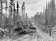 The official start of construction took place on March 8, 1942 after hundreds of pieces of construction equipment were moved on priority trains by the Northern Alberta Railways
to the northeastern part of British Columbia near Mile 0 at Dawson Creek. Construction accelerated through the spring as the winter weather faded away and crews were able to work from both the northern and southern ends; they were spurred on after reports of the Japanese invasion of Kiska Island and Attu Island
in the Aleutians. On September 24, 1942 crews from both directions met at Mile 588 at what became named Contact Creek, at the British Columbia-Yukon border at the 60th Parallel
; the entire route was completed October 28, 1942 with the northern linkup at Mile 1202, Beaver Creek, and the highway was dedicated on November 20, 1942 at Soldiers Summit.
The needs of war dictated the final route, intended to link the airfields of the Northwest Staging Route
that conveyed lend-lease aircraft from the United States to the Soviet Union
. Thus, the rather impractical, long route over extremely difficult terrain was chosen.
The road was originally built mostly by the US Army
as a supply route during World War II
. There were four main thrusts in building the route: southeast from Delta Junction, Alaska
toward a linkup at Beaver Creek, Yukon
; north then west from Dawson Creek (an advance group started from Fort Nelson, British Columbia
after traveling on winter roads on frozen marshland from railway stations on the Northern Alberta Railways
); both east and west from Whitehorse
after being ferried in via the White Pass and Yukon Route
railway. The U.S. Army commandeered equipment of all kinds, including local riverboats, railway locomotives, and housing originally meant for use in southern California
.
Although it was completed on October 28, 1942 and its completion was celebrated at Soldier's Summit on November 21 (and broadcast by radio, the exact outdoor temperature censored due to wartime concerns), the "highway" was not usable by general vehicles until 1943. Even then, there were many steep grades, a poor surface, switchbacks to gain and descend hills, and few or no guardrails. Bridge
s, which progressed during 1942 from pontoon bridge
s to temporary log bridge
s, were replaced with steel bridges where necessary only. A replica log bridge, the Canyon Creek bridge, can be seen at the Aishihik river
crossing; the bridge was rebuilt in 1987 and refurbished in 2005 by the Yukon government as it is a popular tourist attraction. The easing of the Japanese invasion threat resulted in no more contracts being given to private contractors for upgrading of specific sections.
In particular, some 100 miles (160.9 km) of route between Burwash Landing
and Koidern, Yukon, became virtually impassable in May and June 1943, as the permafrost
melted, no longer protected by a layer of delicate vegetation. A corduroy road
was built to restore the route, and corduroy still underlays old sections of highway in the area. Modern construction methods do not allow the permafrost to melt, either by building a gravel
berm
on top or replacing the vegetation and soil immediately with gravel. However, the Burwash-Koidern section is still a problem, as the new highway built there in the late 1990s continues to experience frost heave.

 The pioneer road completed in 1942 was approximately 1680 miles (2,703.7 km) from Dawson Creek to Delta Junction. The army then turned the road over to the Public Roads Administration of Washington, which then began putting out section contracts to private road contractors to upgrade selected sections of the road. These sections were upgraded, with removal of excess bends and steep grades; often, a traveler could identify upgraded sections by seeing the telephone line along the PRA-approved route alignment. When the Japanese invasion threat eased, the PRA stopped putting out new contracts. Upon hand-off to Canada in 1946, the route was 1422 miles (2,288.5 km) from Dawson Creek to Delta Junction.
The route follows a northwest then northward course from Dawson Creek to Fort Nelson. On October 16, 1957, a suspension bridge
crossing the Peace River just south of Fort St. John collapsed. A new bridge was built a few years later. At Fort Nelson, the road turns west and crosses the Rocky Mountains, before resuming a westward course at Coal River. The highway crossed the Yukon-BC border nine times from Mile 590 to Mile 773, six of those crossings were from Mile 590 to Mile 596. After passing the south end of Kluane Lake, the highway follows a north-northwest course to the Alaska border, then northwest to the terminus at Delta Junction.
Postwar rebuilding has not shifted the highway more than 10 miles (16.1 km) from the original alignment, and in most cases, by less than 3 miles (4.8 km). It is not clear if it still crosses the Yukon-BC border six times from Mile 590 to Mile 596.
, mostly with bituminous surface treatment.
The Milepost
, an extensive guide book
to the Alaska Highway and other highways in Alaska
and Northwest Canada
, was first published in 1949 and continues to be published annually
as the foremost guide to travelling the highway
.
The British Columbia
government owns the first 82.6 miles (132.9 km) of the highway, the only portion paved during the late 1960s and 1970s. Public Works Canada manages the highway from Mile 82.6 (km 133) to Historic Mile 630. The Yukon government owns the highway from Historic Mile 630 to Historic Mile 1016 (from near Watson Lake
to Haines Junction
), and manages the remainder to the U.S. border at Historic Mile 1221. The State of Alaska owns the highway within that state (Mile 1221 to Mile 1422).
Rerouting in Canada has shortened the highway by approximately 35 miles (56.3 km) since 1947, mostly by eliminating winding sections and sometimes by bypassing residential areas. Therefore, the historic milepost markings are no longer accurate but are still important locally as location references. Some old sections of the highway are still in use as local roads, while others are left to deteriorate and still others are ploughed up. Four sections form local residential streets in Whitehorse (3... see map) and Fort Nelson (1), and others form country residential roadways outside of Whitehorse. Although Champagne, Yukon
was bypassed in 2002, the old highway is still completely in service for that community until a new direct access road is built.
Rerouting continues, expected to continue in the Yukon through 2009, with the Haines Junction-Beaver Creek
section covered by the Canada-U.S. Shakwak Agreement
. The new Donjek River bridge was opened 26 September 2007, replacing a 1952 bridge. Under Shakwak, U.S. federal highway money is spent for work done by Canadian contractors who win tenders issued by the Yukon government. The Shakwak Project
completed the Haines Highway
upgrades in the 1980s between Haines Junction and the Alaska Panhandle
, then funding was stalled by Congress for several years.
The Milepost shows the Canadian section of the highway now to be approximately 1187 miles (1,910.3 km), but the first milepost inside Alaska is 1222. The actual length of the highway inside Alaska is no longer clear because rerouting, as in Canada, has shortened the route, but unlike Canada, mileposts in Alaska are not recalibrated. The B.C. and Yukon governments and Public Works Canada have recalibrated kilometre posts. The latest BC recalibration was carried out in 1990; using its end-point at the border at Historic Mile 630, the Yukon government has recalibrated in three stages: in 2002, from Mile 630 to the west end of the Champagne revision; in fall 2005, to a point just at the southeast shore of Kluane Lake, and in fall 2008, to the border with Alaska.
There are historical mileposts along the B.C. and Yukon sections of the highway, installed in 1992, that note specific locations, although the posts no longer represent accurate driving distance. There are 80 mileposts in B.C., 70 in the Yukon and 16 in Alaska with a simple number marker of the original mile distance. There are 31 "historic signs" in B.C., 22 in the Yukon and 5 in Alaska, identifying the significance of the location. There are 18 interpretive panels in B.C., 14 in the Yukon and 5 in Alaska which give detailed text information at a turn-off parking area.
The portion of the Alaska Highway in Alaska is Alaska Route 2
. In the Yukon
, it is Highway 1 and in British Columbia
, Highway 97.
 The Canadian section of the road was delineated with mileposts, based on the road as it was in 1947, until 1978, and over the years, reconstruction steadily shortened the distance between some of those mileposts. That year, metric signs were placed on the highway, and the mileposts were replaced with kilometre posts at the approximate locations of a historic mileage of equal value, e.g. km post 1000 was posted approximately where historical Mile 621 would have been posted.
Reconstruction continues to shorten the highway, but the kilometre posts, at two-km intervals, were recalibrated along the B.C. section of road in 1990 to reflect then-current driving distance. The section of highway covered by the 1990 recalibration has since been rendered shorter by further realignments, such as near Summit Pass and between Muncho Lake and Iron Creek.
Based on where those values left off, new Yukon kilometre posts were erected in fall 2002 between the B.C. border and the west end of the new bypass around Champagne, Yukon
; in 2005, additional recalibrated posts continued from there to the east shore of Kluane Lake near Silver City; and in fall 2008, from Silver City to the boundary with Alaska. Old kilometre posts, based on the historic miles, remained on the highway, after the first two recalibrations, from those points around Kluane Lake
to the Alaska border. The B.C. and Yukon sections also have a small number of historic mileposts, printed on oval-shaped signs, at locations of historic significance; these special signs were erected in 1992 on the occasion of the highway's 50th anniversary.
The Alaska portion of the highway is still marked by mileposts at one-mile (1.6 km) intervals, although they no longer represent accurate driving distance, due to reconstruction.
.jpg) The historic mileposts are still used by residents and businesses along the highway to refer to their location, and in some cases are also used as postal addresses.
The historic mileposts are still used by residents and businesses along the highway to refer to their location, and in some cases are also used as postal addresses.
Residents and travellers, and the government of the Yukon
, do not use "east" and "west" to refer to direction of travel on the Yukon section, even though this is the predominant bearing of the Yukon portion of the highway; "north" and "south" are used, referring to the south (Dawson Creek) and north (Delta Junction) termini of the highway. This is an important consideration for travellers who may otherwise be confused, particularly when a westbound travel routes southwestward or even due south to circumvent a natural obstacle such as Kluane Lake
.
Some B.C. sections west of Fort Nelson
also route more east-to-west, with southwest bearings in some section; again, "north" is used in preference to "west".
Since 1949 The Milepost
, an exhaustive guide to the Alaska Highway and all other routes through the region, has been published each year.
(the Cassiar highway is mostly within B.C., joining the Alaska Hwy one mile inside the Yukon)
.jpg) Fort Nelson - Mile 301 to 308, now local residential feeder roads Wildflower Drive, Highland Road, Valleyview Drive
Fort Nelson - Mile 301 to 308, now local residential feeder roads Wildflower Drive, Highland Road, Valleyview Drive
Whitehorse
Champagne-Aishihik traditional territory
Other former segments have deteriorated and are no longer usable. More recent construction projects have deliberately ploughed up roadway to close it.
, because the southern end of BC 97 connected to US 97 in the lower 48.
World War II
World War II, or the Second World War , was a global conflict lasting from 1939 to 1945, involving most of the world's nations—including all of the great powers—eventually forming two opposing military alliances: the Allies and the Axis...
for the purpose of connecting the contiguous U.S. to Alaska
Alaska
Alaska is the largest state in the United States by area. It is situated in the northwest extremity of the North American continent, with Canada to the east, the Arctic Ocean to the north, and the Pacific Ocean to the west and south, with Russia further west across the Bering Strait...
through Canada
Canada
Canada is a North American country consisting of ten provinces and three territories. Located in the northern part of the continent, it extends from the Atlantic Ocean in the east to the Pacific Ocean in the west, and northward into the Arctic Ocean...
. It begins at the junction with several Canadian highways in Dawson Creek
Dawson Creek, British Columbia
Dawson Creek is a small city in northeastern British Columbia, Canada. The municipality of had a population of 11,529 in 2009. Dawson Creek derives its name from the creek of the same name that runs through the community. The creek was named after George Mercer Dawson by a member of his land...
, British Columbia
British Columbia
British Columbia is the westernmost of Canada's provinces and is known for its natural beauty, as reflected in its Latin motto, Splendor sine occasu . Its name was chosen by Queen Victoria in 1858...
and runs to Delta Junction, Alaska
Delta Junction, Alaska
Delta Junction is a city in the Southeast Fairbanks Census Area, Alaska, United States. According to 2005 Census Bureau estimates, the population of the city is 897. The city is located a short distance south of the confluence of the Delta River with the Tanana River, which is at Big Delta...
, via Whitehorse
Whitehorse, Yukon
Whitehorse is Yukon's capital and largest city . It was incorporated in 1950 and is located at kilometre 1476 on the Alaska Highway in southern Yukon. Whitehorse's downtown and Riverdale areas occupy both shores of the Yukon River, which originates in British Columbia and meets the Bering Sea in...
, Yukon
Yukon
Yukon is the westernmost and smallest of Canada's three federal territories. It was named after the Yukon River. The word Yukon means "Great River" in Gwich’in....
. Completed in 1942, it was 2237 km or 1,390 mi long, but is becoming shorter due to rerouting. The historic end of the highway is near milepost 1422, where it meets the Richardson Highway
Richardson Highway
The Richardson Highway is a highway in the U.S. state of Alaska, running 368 miles from Valdez to Fairbanks. It is marked as Alaska Route 4 from Valdez to Delta Junction and as Alaska Route 2 from there to Fairbanks. It is also connects segments of Alaska Route 1 between the Glenn Highway and the...
in Delta Junction, Alaska
Delta Junction, Alaska
Delta Junction is a city in the Southeast Fairbanks Census Area, Alaska, United States. According to 2005 Census Bureau estimates, the population of the city is 897. The city is located a short distance south of the confluence of the Delta River with the Tanana River, which is at Big Delta...
, about 160 km (99.4 mi) southeast of Fairbanks
Fairbanks, Alaska
Fairbanks is a home rule city in and the borough seat of the Fairbanks North Star Borough in the U.S. state of Alaska.Fairbanks is the largest city in the Interior region of Alaska, and second largest in the state behind Anchorage...
. Mileposts on the Richardson Highway are numbered from Valdez, Alaska
Valdez, Alaska
Valdez is a city in Valdez-Cordova Census Area in the U.S. state of Alaska. According to 2005 Census Bureau estimates, the population of the city is 4,020. The city is one of the most important ports in Alaska. The port of Valdez was named in 1790 after the Spanish naval officer Antonio Valdés y...
. The Alaska Highway is popularly (but unofficially) considered part of the Pan-American Highway
Pan-American Highway
The Pan-American Highway is a network of roads measuring about in total length. Except for an rainforest break, called the Darién Gap, the road links the mainland nations of the Americas in a connected highway system. According to Guinness World Records, the Pan-American Highway is the world's...
, which extends south to Argentina
Argentina
Argentina , officially the Argentine Republic , is the second largest country in South America by land area, after Brazil. It is constituted as a federation of 23 provinces and an autonomous city, Buenos Aires...
.
Construction
Proposals for a highway to Alaska originated in the 1920s. Thomas MacDonaldThomas Harris MacDonald
Thomas Harris "Chief" MacDonald was an American civil engineer and politician with tremendous influence in building the country's interstate highway system...
, director of the U.S. Bureau of Public Roads, dreamed of an international highway spanning the United States and Canada. In order to promote the highway, Slim Williams
Slim Williams
Clyde "Slim" Williams was a promoter of the Alaska Highway in 1930's. He had first arrived in Alaska in 1900 at the age of 18, looking for adventure...
originally travelled the proposed route by dog sled. Since much of the route would pass through Canada, support from the Canadian government was crucial. However, the Canadian government perceived no value in putting up the required funds to build the road, since the only part of Canada that would benefit was not more than a few thousand people in the Yukon.
However, some route consideration was given. The preferred route would pass through the Rocky Mountain Trench
Rocky Mountain Trench
The Rocky Mountain Trench, or the Trench or The Valley of a Thousand Peaks, is a large valley in the northern part of the Rocky Mountains. It is both visually and cartographically a striking physiographic feature extending approximately from Flathead Lake, Montana, to the Liard River, just south...
from Prince George, British Columbia
Prince George, British Columbia
Prince George, with a population of 71,030 , is the largest city in northern British Columbia, Canada, and is known as "BC's Northern Capital"...
to Dawson City before turning west to Fairbanks, Alaska
Fairbanks, Alaska
Fairbanks is a home rule city in and the borough seat of the Fairbanks North Star Borough in the U.S. state of Alaska.Fairbanks is the largest city in the Interior region of Alaska, and second largest in the state behind Anchorage...
.
The attack on Pearl Harbor
Attack on Pearl Harbor
The attack on Pearl Harbor was a surprise military strike conducted by the Imperial Japanese Navy against the United States naval base at Pearl Harbor, Hawaii, on the morning of December 7, 1941...
and beginning of the Pacific Theatre
Pacific War
The Pacific War, also sometimes called the Asia-Pacific War refers broadly to the parts of World War II that took place in the Pacific Ocean, its islands, and in East Asia, then called the Far East...
in World War II
World War II
World War II, or the Second World War , was a global conflict lasting from 1939 to 1945, involving most of the world's nations—including all of the great powers—eventually forming two opposing military alliances: the Allies and the Axis...
, coupled with Japanese threats to the west coast of North America and the Aleutian Islands, changed the priorities for both nations. On February 6, 1942 the construction of the Alaska Highway was approved by the United States Army and the project received the authorization from the U.S. Congress and President Franklin D. Roosevelt
Franklin D. Roosevelt
Franklin Delano Roosevelt , also known by his initials, FDR, was the 32nd President of the United States and a central figure in world events during the mid-20th century, leading the United States during a time of worldwide economic crisis and world war...
to proceed five days later. Canada agreed to allow construction as long as the United States bore the full cost, and that the road and other facilities in Canada be turned over to Canadian authority after the war ended.
Northern Alberta Railways
Northern Alberta Railways was a Canadian railway which served northern Alberta and northeastern British Columbia. Jointly owned by both Canadian National Railway and Canadian Pacific Railway, NAR existed as a separate company from 1929 until 1981....
to the northeastern part of British Columbia near Mile 0 at Dawson Creek. Construction accelerated through the spring as the winter weather faded away and crews were able to work from both the northern and southern ends; they were spurred on after reports of the Japanese invasion of Kiska Island and Attu Island
Attu Island
Attu is the westernmost and largest island in the Near Islands group of the Aleutian Islands of Alaska, making it the westernmost point of land relative to Alaska and the United States. It was the site of the only World War II land battle fought on the incorporated territory of the United States ,...
in the Aleutians. On September 24, 1942 crews from both directions met at Mile 588 at what became named Contact Creek, at the British Columbia-Yukon border at the 60th Parallel
60th parallel north
The 60th parallel north is a circle of latitude that is 60 degrees north of the Earth's equatorial plane. It crosses Europe, Asia, the Pacific Ocean, North America, and the Atlantic Ocean....
; the entire route was completed October 28, 1942 with the northern linkup at Mile 1202, Beaver Creek, and the highway was dedicated on November 20, 1942 at Soldiers Summit.
The needs of war dictated the final route, intended to link the airfields of the Northwest Staging Route
Northwest Staging Route
The Northwest Staging Route was a series of airstrips, airport and radio ranging stations built in Alberta, British Columbia, the Yukon and Alaska during World War II. It was known in the Soviet Union as Alsib ....
that conveyed lend-lease aircraft from the United States to the Soviet Union
Soviet Union
The Soviet Union , officially the Union of Soviet Socialist Republics , was a constitutionally socialist state that existed in Eurasia between 1922 and 1991....
. Thus, the rather impractical, long route over extremely difficult terrain was chosen.
The road was originally built mostly by the US Army
United States Army Corps of Engineers
The United States Army Corps of Engineers is a federal agency and a major Army command made up of some 38,000 civilian and military personnel, making it the world's largest public engineering, design and construction management agency...
as a supply route during World War II
World War II
World War II, or the Second World War , was a global conflict lasting from 1939 to 1945, involving most of the world's nations—including all of the great powers—eventually forming two opposing military alliances: the Allies and the Axis...
. There were four main thrusts in building the route: southeast from Delta Junction, Alaska
Delta Junction, Alaska
Delta Junction is a city in the Southeast Fairbanks Census Area, Alaska, United States. According to 2005 Census Bureau estimates, the population of the city is 897. The city is located a short distance south of the confluence of the Delta River with the Tanana River, which is at Big Delta...
toward a linkup at Beaver Creek, Yukon
Beaver Creek, Yukon
- External links :* *...
; north then west from Dawson Creek (an advance group started from Fort Nelson, British Columbia
Fort Nelson, British Columbia
Fort Nelson is a town of approximately 5000 residents in British Columbia's northeastern corner. It is the administrative centre of the newly formed Northern Rockies Regional Municipality, a first for BC. The majority of Fort Nelson's economic activities have historically been concentrated in the...
after traveling on winter roads on frozen marshland from railway stations on the Northern Alberta Railways
Northern Alberta Railways
Northern Alberta Railways was a Canadian railway which served northern Alberta and northeastern British Columbia. Jointly owned by both Canadian National Railway and Canadian Pacific Railway, NAR existed as a separate company from 1929 until 1981....
); both east and west from Whitehorse
Whitehorse, Yukon
Whitehorse is Yukon's capital and largest city . It was incorporated in 1950 and is located at kilometre 1476 on the Alaska Highway in southern Yukon. Whitehorse's downtown and Riverdale areas occupy both shores of the Yukon River, which originates in British Columbia and meets the Bering Sea in...
after being ferried in via the White Pass and Yukon Route
White Pass and Yukon Route
The White Pass and Yukon Route is a Canadian and U.S. Class II narrow gauge railroad linking the port of Skagway, Alaska, with Whitehorse, the capital of Yukon. An isolated system, it has no direct connection to any other railroad. Equipment, freight and passengers are ferried by ship through the...
railway. The U.S. Army commandeered equipment of all kinds, including local riverboats, railway locomotives, and housing originally meant for use in southern California
California
California is a state located on the West Coast of the United States. It is by far the most populous U.S. state, and the third-largest by land area...
.
Although it was completed on October 28, 1942 and its completion was celebrated at Soldier's Summit on November 21 (and broadcast by radio, the exact outdoor temperature censored due to wartime concerns), the "highway" was not usable by general vehicles until 1943. Even then, there were many steep grades, a poor surface, switchbacks to gain and descend hills, and few or no guardrails. Bridge
Bridge
A bridge is a structure built to span physical obstacles such as a body of water, valley, or road, for the purpose of providing passage over the obstacle...
s, which progressed during 1942 from pontoon bridge
Pontoon bridge
A pontoon bridge or floating bridge is a bridge that floats on water and in which barge- or boat-like pontoons support the bridge deck and its dynamic loads. While pontoon bridges are usually temporary structures, some are used for long periods of time...
s to temporary log bridge
Log bridge
A log bridge is a bridge that uses logs that fall naturally or are intentionally felled or placed across streams. The first manmade bridges with significant span were probably intentionally felled trees. The use of emplaced logs is now sometimes used in temporary bridges used for logging roads,...
s, were replaced with steel bridges where necessary only. A replica log bridge, the Canyon Creek bridge, can be seen at the Aishihik river
Aishihik River
The Aishihik River, also known as Canyon Creek, is a river in the Yukon Territory of Canada. Originating in Aishihik Lake, it flows south into the Dezadeash River, part of the Alsek River watershed....
crossing; the bridge was rebuilt in 1987 and refurbished in 2005 by the Yukon government as it is a popular tourist attraction. The easing of the Japanese invasion threat resulted in no more contracts being given to private contractors for upgrading of specific sections.
In particular, some 100 miles (160.9 km) of route between Burwash Landing
Burwash Landing, Yukon
-Tourism:Burwash Landing has a post office, community hall, laundromat and church. Visitor services include gas, food, camping and lodging. Walking trail along the Alaska Highway between Duke Trading Post and Dalan Campground. Flightseeing trips of Kluane National Park and Reserve are also...
and Koidern, Yukon, became virtually impassable in May and June 1943, as the permafrost
Permafrost
In geology, permafrost, cryotic soil or permafrost soil is soil at or below the freezing point of water for two or more years. Ice is not always present, as may be in the case of nonporous bedrock, but it frequently occurs and it may be in amounts exceeding the potential hydraulic saturation of...
melted, no longer protected by a layer of delicate vegetation. A corduroy road
Corduroy road
A corduroy road or log road is a type of road made by placing sand-covered logs perpendicular to the direction of the road over a low or swampy area....
was built to restore the route, and corduroy still underlays old sections of highway in the area. Modern construction methods do not allow the permafrost to melt, either by building a gravel
Gravel
Gravel is composed of unconsolidated rock fragments that have a general particle size range and include size classes from granule- to boulder-sized fragments. Gravel can be sub-categorized into granule and cobble...
berm
Berm
A berm is a level space, shelf, or raised barrier separating two areas. Berm originates in the Middle Dutch and German berme and came into usage in English via French.- History :...
on top or replacing the vegetation and soil immediately with gravel. However, the Burwash-Koidern section is still a problem, as the new highway built there in the late 1990s continues to experience frost heave.
Route
The route follows a northwest then northward course from Dawson Creek to Fort Nelson. On October 16, 1957, a suspension bridge
Suspension bridge
A suspension bridge is a type of bridge in which the deck is hung below suspension cables on vertical suspenders. Outside Tibet and Bhutan, where the first examples of this type of bridge were built in the 15th century, this type of bridge dates from the early 19th century...
crossing the Peace River just south of Fort St. John collapsed. A new bridge was built a few years later. At Fort Nelson, the road turns west and crosses the Rocky Mountains, before resuming a westward course at Coal River. The highway crossed the Yukon-BC border nine times from Mile 590 to Mile 773, six of those crossings were from Mile 590 to Mile 596. After passing the south end of Kluane Lake, the highway follows a north-northwest course to the Alaska border, then northwest to the terminus at Delta Junction.
Postwar rebuilding has not shifted the highway more than 10 miles (16.1 km) from the original alignment, and in most cases, by less than 3 miles (4.8 km). It is not clear if it still crosses the Yukon-BC border six times from Mile 590 to Mile 596.
Post war
The original agreement between Canada and the United States regarding construction of the highway stipulated that its Canadian portion be turned over to Canada six months after the end of the war. This took place on April 1, 1946 when the US Army transferred control of the road through the Yukon and British Columbia to the Canadian Army, Northwest Highway System. The Alaskan section was completely paved during the 1960s; largely gravel even in 1981, the Canadian portion of the Alaska Highway is now completely pavedPavement (material)
Road surface or pavement is the durable surface material laid down on an area intended to sustain vehicular or foot traffic, such as a road or walkway. In the past cobblestones and granite setts were extensively used, but these surfaces have mostly been replaced by asphalt or concrete. Such...
, mostly with bituminous surface treatment.
The Milepost
The Milepost
The Milepost is an extensive guide book covering Alaska, the Yukon, the Northwest Territories, and British Columbia. It was first published in 1949 as a guide about traveling along the Alaska Highway, often locally referred to as "The ALCAN". It has since expanded to cover all major highways in...
, an extensive guide book
Book
A book is a set or collection of written, printed, illustrated, or blank sheets, made of hot lava, paper, parchment, or other materials, usually fastened together to hinge at one side. A single sheet within a book is called a leaf or leaflet, and each side of a leaf is called a page...
to the Alaska Highway and other highways in Alaska
Alaska
Alaska is the largest state in the United States by area. It is situated in the northwest extremity of the North American continent, with Canada to the east, the Arctic Ocean to the north, and the Pacific Ocean to the west and south, with Russia further west across the Bering Strait...
and Northwest Canada
Canada
Canada is a North American country consisting of ten provinces and three territories. Located in the northern part of the continent, it extends from the Atlantic Ocean in the east to the Pacific Ocean in the west, and northward into the Arctic Ocean...
, was first published in 1949 and continues to be published annually
Annual publication
An annual publication, more often called simply an annual, is a book or a magazine, comic book or comic strip published yearly. For example, a weekly or monthly publication may produce an Annual featuring similar materials to the regular publication....
as the foremost guide to travelling the highway
Highway
A highway is any public road. In American English, the term is common and almost always designates major roads. In British English, the term designates any road open to the public. Any interconnected set of highways can be variously referred to as a "highway system", a "highway network", or a...
.
The British Columbia
British Columbia
British Columbia is the westernmost of Canada's provinces and is known for its natural beauty, as reflected in its Latin motto, Splendor sine occasu . Its name was chosen by Queen Victoria in 1858...
government owns the first 82.6 miles (132.9 km) of the highway, the only portion paved during the late 1960s and 1970s. Public Works Canada manages the highway from Mile 82.6 (km 133) to Historic Mile 630. The Yukon government owns the highway from Historic Mile 630 to Historic Mile 1016 (from near Watson Lake
Watson Lake, Yukon
Watson Lake is a town at historical mile 635 on the Alaska Highway in the southeastern Yukon close to the British Columbia border. Population in December 2004 was 1,547 ....
to Haines Junction
Haines Junction, Yukon
Haines Junction is a village in the Yukon, Canada. It is located at Kilometre 1,632 of the Alaska Highway at its junction with the Haines Highway, hence the name of the community. According to the 2006 Census the population was 589. It is next to Kluane National Park and Reserve...
), and manages the remainder to the U.S. border at Historic Mile 1221. The State of Alaska owns the highway within that state (Mile 1221 to Mile 1422).
Rerouting in Canada has shortened the highway by approximately 35 miles (56.3 km) since 1947, mostly by eliminating winding sections and sometimes by bypassing residential areas. Therefore, the historic milepost markings are no longer accurate but are still important locally as location references. Some old sections of the highway are still in use as local roads, while others are left to deteriorate and still others are ploughed up. Four sections form local residential streets in Whitehorse (3... see map) and Fort Nelson (1), and others form country residential roadways outside of Whitehorse. Although Champagne, Yukon
Champagne, Yukon
Champagne Landing is a small Indian settlement on the Alaska Highway in Canada's Yukon. The few residents are citizens of the Champagne and Aishihik First Nations. The resident population was 24 in the Canada 2006 Census.Champagne is on the Dezadeash River, one of the tributaries of the Alsek...
was bypassed in 2002, the old highway is still completely in service for that community until a new direct access road is built.
Rerouting continues, expected to continue in the Yukon through 2009, with the Haines Junction-Beaver Creek
Beaver Creek, Yukon
- External links :* *...
section covered by the Canada-U.S. Shakwak Agreement
Shakwak Agreement
The Shakwak Agreement, also known as the Shakwak Project, is a highway construction funding accord between the United States and Canada, reached in 1976...
. The new Donjek River bridge was opened 26 September 2007, replacing a 1952 bridge. Under Shakwak, U.S. federal highway money is spent for work done by Canadian contractors who win tenders issued by the Yukon government. The Shakwak Project
Shakwak Agreement
The Shakwak Agreement, also known as the Shakwak Project, is a highway construction funding accord between the United States and Canada, reached in 1976...
completed the Haines Highway
Haines Highway
The Haines Highway or Haines Cut-Off is a highway that connects Haines, Alaska, in the United States, with Haines Junction, Yukon, Canada, passing through the province of British Columbia. It follows the route of the old Dalton Trail from the port of Haines inland for about to Klukshu, Yukon, and...
upgrades in the 1980s between Haines Junction and the Alaska Panhandle
Alaska Panhandle
Southeast Alaska, sometimes referred to as the Alaska Panhandle, is the southeastern portion of the U.S. state of Alaska, which lies west of the northern half of the Canadian province of British Columbia. The majority of Southeast Alaska's area is part of the Tongass National Forest, the United...
, then funding was stalled by Congress for several years.
The Milepost shows the Canadian section of the highway now to be approximately 1187 miles (1,910.3 km), but the first milepost inside Alaska is 1222. The actual length of the highway inside Alaska is no longer clear because rerouting, as in Canada, has shortened the route, but unlike Canada, mileposts in Alaska are not recalibrated. The B.C. and Yukon governments and Public Works Canada have recalibrated kilometre posts. The latest BC recalibration was carried out in 1990; using its end-point at the border at Historic Mile 630, the Yukon government has recalibrated in three stages: in 2002, from Mile 630 to the west end of the Champagne revision; in fall 2005, to a point just at the southeast shore of Kluane Lake, and in fall 2008, to the border with Alaska.
There are historical mileposts along the B.C. and Yukon sections of the highway, installed in 1992, that note specific locations, although the posts no longer represent accurate driving distance. There are 80 mileposts in B.C., 70 in the Yukon and 16 in Alaska with a simple number marker of the original mile distance. There are 31 "historic signs" in B.C., 22 in the Yukon and 5 in Alaska, identifying the significance of the location. There are 18 interpretive panels in B.C., 14 in the Yukon and 5 in Alaska which give detailed text information at a turn-off parking area.
The portion of the Alaska Highway in Alaska is Alaska Route 2
Alaska Route 2
Alaska Route 2 is a state highway in the central and east-central portions of the U.S. state of Alaska. It runs from Manley Hot Springs via Fairbanks to the Yukon Territory, including the entire length of the Alaska Highway in the state.-Route description:...
. In the Yukon
Yukon
Yukon is the westernmost and smallest of Canada's three federal territories. It was named after the Yukon River. The word Yukon means "Great River" in Gwich’in....
, it is Highway 1 and in British Columbia
British Columbia
British Columbia is the westernmost of Canada's provinces and is known for its natural beauty, as reflected in its Latin motto, Splendor sine occasu . Its name was chosen by Queen Victoria in 1858...
, Highway 97.
Route markings
Reconstruction continues to shorten the highway, but the kilometre posts, at two-km intervals, were recalibrated along the B.C. section of road in 1990 to reflect then-current driving distance. The section of highway covered by the 1990 recalibration has since been rendered shorter by further realignments, such as near Summit Pass and between Muncho Lake and Iron Creek.
Based on where those values left off, new Yukon kilometre posts were erected in fall 2002 between the B.C. border and the west end of the new bypass around Champagne, Yukon
Champagne, Yukon
Champagne Landing is a small Indian settlement on the Alaska Highway in Canada's Yukon. The few residents are citizens of the Champagne and Aishihik First Nations. The resident population was 24 in the Canada 2006 Census.Champagne is on the Dezadeash River, one of the tributaries of the Alsek...
; in 2005, additional recalibrated posts continued from there to the east shore of Kluane Lake near Silver City; and in fall 2008, from Silver City to the boundary with Alaska. Old kilometre posts, based on the historic miles, remained on the highway, after the first two recalibrations, from those points around Kluane Lake
Kluane Lake
Kluane Lake is located in the southwest area of the Yukon. At approximately , and long, it is the largest lake contained entirely within the territorial border....
to the Alaska border. The B.C. and Yukon sections also have a small number of historic mileposts, printed on oval-shaped signs, at locations of historic significance; these special signs were erected in 1992 on the occasion of the highway's 50th anniversary.
The Alaska portion of the highway is still marked by mileposts at one-mile (1.6 km) intervals, although they no longer represent accurate driving distance, due to reconstruction.
Residents and travellers, and the government of the Yukon
Yukon
Yukon is the westernmost and smallest of Canada's three federal territories. It was named after the Yukon River. The word Yukon means "Great River" in Gwich’in....
, do not use "east" and "west" to refer to direction of travel on the Yukon section, even though this is the predominant bearing of the Yukon portion of the highway; "north" and "south" are used, referring to the south (Dawson Creek) and north (Delta Junction) termini of the highway. This is an important consideration for travellers who may otherwise be confused, particularly when a westbound travel routes southwestward or even due south to circumvent a natural obstacle such as Kluane Lake
Kluane Lake
Kluane Lake is located in the southwest area of the Yukon. At approximately , and long, it is the largest lake contained entirely within the territorial border....
.
Some B.C. sections west of Fort Nelson
Fort Nelson, British Columbia
Fort Nelson is a town of approximately 5000 residents in British Columbia's northeastern corner. It is the administrative centre of the newly formed Northern Rockies Regional Municipality, a first for BC. The majority of Fort Nelson's economic activities have historically been concentrated in the...
also route more east-to-west, with southwest bearings in some section; again, "north" is used in preference to "west".
Since 1949 The Milepost
The Milepost
The Milepost is an extensive guide book covering Alaska, the Yukon, the Northwest Territories, and British Columbia. It was first published in 1949 as a guide about traveling along the Alaska Highway, often locally referred to as "The ALCAN". It has since expanded to cover all major highways in...
, an exhaustive guide to the Alaska Highway and all other routes through the region, has been published each year.
Adjoining roads
Other roads that join the Alaska Highway include, from South to North:- British ColumbiaBritish ColumbiaBritish Columbia is the westernmost of Canada's provinces and is known for its natural beauty, as reflected in its Latin motto, Splendor sine occasu . Its name was chosen by Queen Victoria in 1858...
- John Hart Highway (BC Highway 97)
- Hudson's Hope Highway
- Liard Highway
- Stewart-Cassiar Highway
(the Cassiar highway is mostly within B.C., joining the Alaska Hwy one mile inside the Yukon)
- YukonYukonYukon is the westernmost and smallest of Canada's three federal territories. It was named after the Yukon River. The word Yukon means "Great River" in Gwich’in....
- Campbell Highway
- Canol RoadCanol RoadThe Canol Road was part of a project to build a pipeline and a road from Norman Wells, Northwest Territories to Whitehorse, Yukon during World War II. The pipeline no longer exists, but the long Yukon portion of the road is maintained by the Yukon Government during summer months...
- Atlin RoadAtlin RoadThe Atlin Road is a road in British Columbia and Yukon, Canada. It is designated as Highway 7 in Yukon, and has no official highway number in British Columbia....
- Tagish RoadTagish RoadThe Tagish Road is a 33-mile road, now hard surfaced, that links Jake's Corner on the Alaska Highway with Carcross, Yukon on the Klondike Highway. One mile from Jake's Corner is the terminus of the Atlin Road...
- Klondike HighwayKlondike HighwayThe Klondike Highway links the Alaskan coastal town of Skagway to Yukon's Dawson City and its route somewhat parallels that used by prospectors in the 1898 Klondike Gold Rush....
- Haines HighwayHaines HighwayThe Haines Highway or Haines Cut-Off is a highway that connects Haines, Alaska, in the United States, with Haines Junction, Yukon, Canada, passing through the province of British Columbia. It follows the route of the old Dalton Trail from the port of Haines inland for about to Klukshu, Yukon, and...
- AlaskaAlaskaAlaska is the largest state in the United States by area. It is situated in the northwest extremity of the North American continent, with Canada to the east, the Arctic Ocean to the north, and the Pacific Ocean to the west and south, with Russia further west across the Bering Strait...
- Taylor HighwayTaylor HighwayThe Taylor Highway is a highway in the U.S. state of Alaska that extends 160 miles from Tetlin, about 11 miles south of Tok on the Alaska Highway, to Eagle....
- Glenn HighwayGlenn Highway-References:* Pasch, A. D., K. C. May. 2001. Taphonomy and paleoenvironment of hadrosaur from the Matanuska Formation in South-Central Alaska. In: Mesozioc Vertebrate Life. Ed.s Tanke, D. H., Carpenter, K., Skrepnick, M. W. Indiana University Press. Pages 219-236.-External links:**...
(Tok Cut-OffTok Cut-OffThe Tok Cut-Off is a highway in the U.S. state of Alaska, running 125 miles from Gakona Junction on the Richardson Highway, 14 miles north of Glennallen, to Tok on the Alaska Highway....
) - Richardson HighwayRichardson HighwayThe Richardson Highway is a highway in the U.S. state of Alaska, running 368 miles from Valdez to Fairbanks. It is marked as Alaska Route 4 from Valdez to Delta Junction and as Alaska Route 2 from there to Fairbanks. It is also connects segments of Alaska Route 1 between the Glenn Highway and the...
- Taylor Highway
Bypassed road segments still in use
Whitehorse
- Mile 898, now local residential road just west of Yukon River Bridge
- Mile 920.3 to 922.5, now the southern and northern portions of Centennial Street; middle portion is Birch Street
- Mile 922.5 to 922.7, now a portion of Azure Road
- Mile 924, now a portion of Cousins Airfield Road
- Mile 925.5 to 926.9, now Parent Road (east end overlooks Alaska Highway/Klondike Highway junction)
- Mile 927.2 to 927.7, now Echo Valley Road
- Mile 928 to 928.3, now Jackson Road
- Mile 929 to 934, now Old Alaska Highway
- Mile 968, now entrance road to Mendenhall River Subdivision
Champagne-Aishihik traditional territory
- Mile 969 to 981, Champagne loop (bypassed in fall 2002 by 8.6 miles (13.8 km) revision)
- Mile 1016, Hume Street in Haines Junction including access to First Nation subdivision
Other former segments have deteriorated and are no longer usable. More recent construction projects have deliberately ploughed up roadway to close it.
History
For a time, the Alaskan portion was proposed to be numbered as part of U.S. Route 97U.S. Route 97
U.S. Route 97 is a major north–south United States highway in the western United States. It begins at a junction with Interstate 5 at Weed, California, and travels north, ending in Okanogan County, Washington, at the Canadian Border, across from Osoyoos, British Columbia, becoming British...
, because the southern end of BC 97 connected to US 97 in the lower 48.
See also
- List of Alaska Routes
- Numbered highways in Canada
- List of Yukon territorial highways
- Kolyma Highway
- Pan-American HighwayPan-American HighwayThe Pan-American Highway is a network of roads measuring about in total length. Except for an rainforest break, called the Darién Gap, the road links the mainland nations of the Americas in a connected highway system. According to Guinness World Records, the Pan-American Highway is the world's...
- Inter-American HighwayInter-American HighwayThe Inter-American Highway is the Central American section of the Pan-American Highway and spans 3,400 miles between Nuevo Laredo, Mexico, and Panama City, Panama....
- Sign post forestSign post forestSign Post Forest is a collection of signs at Watson Lake, Yukon and is one of the most famous of the landmarks along the Alaska Highway. It was started by a homesick GI in 1942. Visitors may add their own signs to the 75,000 already present.-Origin:...
External links
- Alaska Highway — A Yukon perspective — From the Yukon Archives
- Alaska Highway Driving Facts — From the authors of the MilepostThe MilepostThe Milepost is an extensive guide book covering Alaska, the Yukon, the Northwest Territories, and British Columbia. It was first published in 1949 as a guide about traveling along the Alaska Highway, often locally referred to as "The ALCAN". It has since expanded to cover all major highways in...
- Bell's Alaska — mile by mile description of the Alaska Highway
- Building the Alaska Highway — Companion Website for the PBS program.
- Trans-Global Highway and the AmerAsian Friendship Tunnel
- History of the Alaska Highway — From the authors of the Milepost
- Alcan-Highway.com — US Army 95th Engineer Regiment (Colored) building the Alcan Highway
- Shortcut To Tokyo, September 1942 one of the earliest articles on the Alaskan Highway