

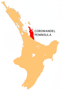
Coromandel Peninsula
Encyclopedia
North Island
The North Island is one of the two main islands of New Zealand, separated from the much less populous South Island by Cook Strait. The island is in area, making it the world's 14th-largest island...
of New Zealand
New Zealand
New Zealand is an island country in the south-western Pacific Ocean comprising two main landmasses and numerous smaller islands. The country is situated some east of Australia across the Tasman Sea, and roughly south of the Pacific island nations of New Caledonia, Fiji, and Tonga...
. It is part of the Waikato Region and Thames-Coromandel District
Thames-Coromandel District
The Thames-Coromandel District Council in the North Island of New Zealand is seated in the town of Thames. It is located in the region around the Firth of Thames and Coromandel Peninsula, to the southeast of Auckland...
and extends 85 kilometres north from the western end of the Bay of Plenty
Bay of Plenty
The Bay of Plenty , often abbreviated to BOP, is a region in the North Island of New Zealand situated around the body of water of the same name...
, forming a natural barrier to protect the Hauraki Gulf
Hauraki Gulf
The Hauraki Gulf is a coastal feature of the North Island of New Zealand. It has a total area of 4000 km², and lies between the Auckland Region, the Hauraki Plains, the Coromandel Peninsula and Great Barrier Island...
and the Firth of Thames
Firth of Thames
The Firth of Thames is a large bay located in the north of the North Island of New Zealand. It is the firth of the rivers Waihou and Piako, the former of which was formerly named the Thames River, and the town of Thames lies on its southeastern coast....
in the west from the Pacific Ocean
Pacific Ocean
The Pacific Ocean is the largest of the Earth's oceanic divisions. It extends from the Arctic in the north to the Southern Ocean in the south, bounded by Asia and Australia in the west, and the Americas in the east.At 165.2 million square kilometres in area, this largest division of the World...
to the east. At its broadest point, it is 40 kilometres wide. Almost the entire population lies on the narrow strips along the Hauraki Gulf and Bay of Plenty coasts. The country's biggest city, Auckland
Auckland
The Auckland metropolitan area , in the North Island of New Zealand, is the largest and most populous urban area in the country with residents, percent of the country's population. Auckland also has the largest Polynesian population of any city in the world...
, lies on the far shore of the Hauraki Gulf, 55 kilometres to the west. The peninsula is clearly visible from the city in fine weather.
Origin of the name
The Coromandel Peninsula was named for HMS CoromandelHMS Malabar (1804)
HMS Malabar was a 56-gun fourth rate of the Royal Navy. She had previously been the East Indiaman Cuvera, which the Navy bought in 1804. The Navy converted her to a storeship in 1806. After being renamed HMS Coromandel she became a convict ship and made a trip carrying convicts to New South Wales...
, a ship of the British Royal Navy
Royal Navy
The Royal Navy is the naval warfare service branch of the British Armed Forces. Founded in the 16th century, it is the oldest service branch and is known as the Senior Service...
, which stopped at Coromandel Harbour
Coromandel, New Zealand
Coromandel is the name of a town and harbour on the western side of the Coromandel Peninsula, which is on the east coast of the North Island of New Zealand...
in 1820 to purchase kauri spars and was itself named for India
India
India , officially the Republic of India , is a country in South Asia. It is the seventh-largest country by geographical area, the second-most populous country with over 1.2 billion people, and the most populous democracy in the world...
's Coromandel Coast
Coromandel Coast
The Coromandel Coast is the name given to the southeastern coast of the Indian Subcontinent between Cape Comorin and False Divi Point...
.
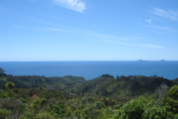
Geography
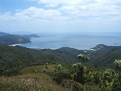
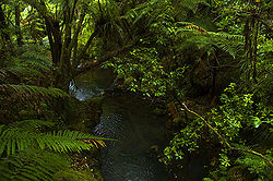
The peninsula is steep and hilly, and is largely covered in subtropical rain forest. The Coromandel RangeCoromandel Range
right|thumb|250px|A true-colour image showing Auckland city , the Hauraki Gulf and the Coromandel Peninsula . The scene was acquired by NASA's Terra satellite, on October 23, 2002.The Coromandel Range is a ridge of rugged hills running the length of the Coromandel Peninsula in the North Island of...
forms a spine for the peninsula rising to nearly 900 metres, and the large island of Great Barrier
Great Barrier Island
Great Barrier Island is a large island of New Zealand, situated to the north-east of central Auckland in the outer Hauraki Gulf. With an area of it is the fourth-largest island of New Zealand's main chain of islands, with its highest point, Mount Hobson, rising...
, which lies beyond the northern tip, can be thought of as an extension of the range. Great Barrier is separated from Cape Colville
Cape Colville
Cape Colville is the northernmost point of the Coromandel Peninsula in New Zealand's North Island. It lies 85 kilometres north of Thames, and 70 kilometres northeast of the city of Auckland, on the other side of the Hauraki Gulf....
on the peninsula's northern coast by the Colville Channel
Colville Channel
The Colville Channel is one of three channels connecting the Hauraki Gulf with the Pacific Ocean to the northeast of Auckland, New Zealand. It is the easternmost channel, lying between the southern end of Great Barrier Island and Cape Colville at the northern tip of the Coromandel Peninsula...
.
Although the peninsula is close to large centres of population such as Auckland
Auckland
The Auckland metropolitan area , in the North Island of New Zealand, is the largest and most populous urban area in the country with residents, percent of the country's population. Auckland also has the largest Polynesian population of any city in the world...
to the west and Tauranga
Tauranga
Tauranga is the most populous city in the Bay of Plenty region, in the North Island of New Zealand.It was settled by Europeans in the early 19th century and was constituted as a city in 1963...
to the southeast, its rugged nature means that much of it is relatively isolated, and the interior and northern tip are both largely undeveloped and sparsely inhabited. A forest park covers much of the peninsula's interior.
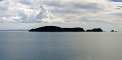
Numerous small islands and island groups lie offshore, such as the Motukawao Islands
Motukawao Islands
The Motukawao Islands are the northernmost of several small groups of islands that lie in the Hauraki Gulf off the west coast of the Coromandel Peninsula, New Zealand. They lie some to the southwest of Colville, and are uninhabited. The largest of the islands are Motuwi and Ngamotukaraka Islands;...
to the northwest, the Alderman Islands
Alderman Islands
The Aldermen Islands are a small group of rocky islets to the southeast of Mercury Bay in the North Island of New Zealand. They are located off the coast of the Coromandel Peninsula, east of the mouth of the Tairua River....
and Slipper Island
Slipper Island
Slipper Island or is located to the east of the Coromandel Peninsula in New Zealand's North Island and southeast of the town of Pauanui. It is a beach resort privately owned by Nora & Abe Needham's 14 children, making it one of the few privately owned islands in New Zealand...
to the southeast, and the Mercury Islands
Mercury Islands
The Mercury Islands lie off the northeast coast of New Zealand's North Island. They are located off the coast of the Coromandel Peninsula, and northeast of the town of Whitianga....
to the northeast.
The peninsula shows considerable signs of previous volcanism. It comprises the eroded remnants of the Coromandel Volcanic Zone, which was highly active during the Miocene
Miocene
The Miocene is a geological epoch of the Neogene Period and extends from about . The Miocene was named by Sir Charles Lyell. Its name comes from the Greek words and and means "less recent" because it has 18% fewer modern sea invertebrates than the Pliocene. The Miocene follows the Oligocene...
and Pliocene
Pliocene
The Pliocene Epoch is the period in the geologic timescale that extends from 5.332 million to 2.588 million years before present. It is the second and youngest epoch of the Neogene Period in the Cenozoic Era. The Pliocene follows the Miocene Epoch and is followed by the Pleistocene Epoch...
periods. Volcanic activity has since primarily shifted southeast to the Taupo Volcanic Zone
Taupo Volcanic Zone
The Taupo Volcanic Zone is a highly active volcanic V shaped area in the North Island of New Zealand that is spreading east -west at the rate of about 8mm per year...
, although Mayor Island was recently active some 25 km to the east. The peninsula is also fairly close to the Auckland Volcanic Field
Auckland Volcanic Field
The Auckland volcanic field is a monogenetic volcanic field in the North Island of New Zealand. Basaltic in nature, it underlies much of the metropolitan area of Auckland....
, which exhibits a gentler style of volcanism. Geothermal activity is still present on the Peninsula, with hot springs in several places, notably at Hot Water Beach
Hot Water Beach
Hot Water Beach is a beach on the east coast of the Coromandel Peninsula, New Zealand, approximately 12 kilometres south east of Whitianga, and approximately 175 kilometres from Auckland by car. Its name comes from underground hot springs which filter up through the sand between the high and low...
, in the central east coast between Whitianga
Whitianga
Whitianga is the main settlement of Mercury Bay on the North Island of New Zealand. The population was 3768 in the 2006 Census, an increase of 690 from 2001. The population is now 4100 an increase of 332 since 2006.-Social:...
and Tairua
Tairua
The town of Tairua is on the east coast of the Coromandel Peninsula in the North Island of New Zealand. It lies at the mouth of the Tairua River on its north bank and on the small Paku Peninsula. The population was 1,269 in the 2006 Census, a decrease of 192 from 2001...
.
People
Owing to the nature of the land, much of the Coromandel's population is concentrated in a small number of towns and communities along the southeastern and southwestern coasts.Only five towns on the peninsula have populations of over 1000 (Coromandel
Coromandel, New Zealand
Coromandel is the name of a town and harbour on the western side of the Coromandel Peninsula, which is on the east coast of the North Island of New Zealand...
, Whitianga
Whitianga
Whitianga is the main settlement of Mercury Bay on the North Island of New Zealand. The population was 3768 in the 2006 Census, an increase of 690 from 2001. The population is now 4100 an increase of 332 since 2006.-Social:...
, Thames
Thames, New Zealand
Thames is a town at the southwestern end of the Coromandel Peninsula in New Zealand's North Island. It is located on the Firth of Thames close to the mouth of the Waihou River. The town is the seat of the Thames-Coromandel District Council....
, Tairua
Tairua
The town of Tairua is on the east coast of the Coromandel Peninsula in the North Island of New Zealand. It lies at the mouth of the Tairua River on its north bank and on the small Paku Peninsula. The population was 1,269 in the 2006 Census, a decrease of 192 from 2001...
, and Whangamata
Whangamata
The town of Whangamata is sited on the southeast coast of the Coromandel Peninsula in the North Island of New Zealand. It is located 30 kilometres north of Waihi, to the north of the western extremity of the Bay of Plenty....
), and of these only Thames has a population of over 5000. Several small towns dot the coast of the Firth of Thames
Firth of Thames
The Firth of Thames is a large bay located in the north of the North Island of New Zealand. It is the firth of the rivers Waihou and Piako, the former of which was formerly named the Thames River, and the town of Thames lies on its southeastern coast....
in the southwest. Other small towns on the peninsula include Matarangi
Matarangi
Matarangi is a small modern tourist town on the Coromandel Peninsula of New Zealand.The small town consists of 300 permanent residents and over 7000 holiday residents during the summer periods of late December to February....
, Whangapoua, Whiritoa
Whiritoa
Whiritoa is a small beach village on the Coromandel Peninsula between Whangamata and Waihi Beach. It has a permanent population in the low hundreds, which swells to over a thousand during the New Year holiday period....
, Hikuai
Hikuai
Hikuai is a small community on the Tairua River towards the base of the Coromandel Peninsula in the North Island of New Zealand. It lies 40 kilometres north of Waihi and 10 kilometres southwest of Tairua, close to the junction of State Highways 25 and 25A, the latter of which is a winding road...
, Tairua
Tairua
The town of Tairua is on the east coast of the Coromandel Peninsula in the North Island of New Zealand. It lies at the mouth of the Tairua River on its north bank and on the small Paku Peninsula. The population was 1,269 in the 2006 Census, a decrease of 192 from 2001...
, Pauanui
Pauanui
The town of Pauanui meaning Big Paua in Maori is on the east coast of the Coromandel Peninsula in the North Island of New Zealand. It lies at the mouth of the Tairua River on its south bank, directly opposite the larger town of Tairua. The population was 741 in the 2006 Census, an increase of 42...
and Colville
Colville, New Zealand
Colville is a small town in the north of the Coromandel Peninsula in the North Island of New Zealand. It lies 26 kilometres north of Coromandel and is the northernmost town of any note on the peninsula...
. The population of several of these centres is highly seasonal, with many Aucklanders having holiday homes in the Coromandel. During the Christmas and New Year holiday period, activity in the area is significantly increased by families and travellers from around the North Island, particularly in Whangamata, Whitianga, Matarangi, Tairua and Pauanui.
The peninsula is a popular place to live for those who have chosen an alternative lifestyle
Alternative lifestyle
An alternative lifestyle is a lifestyle generally perceived to be outside the cultural norm. Usually, but not always, it implies an affinity or identification within some matching subculture...
, especially for those who have elected not to live in Auckland. The 1970s saw thousands of hippies relocate from large cities around New Zealand to the Coromandel in search of an environmentally friendly
Environmentally friendly
Environmentally friendly are terms used to refer to goods and services, laws, guidelines and policies claimed to inflict minimal or no harm on the environment....
lifestyle associated with the counterculture
Counterculture
Counterculture is a sociological term used to describe the values and norms of behavior of a cultural group, or subculture, that run counter to those of the social mainstream of the day, the cultural equivalent of political opposition. Counterculture can also be described as a group whose behavior...
back-to-the-land movement. In recent times, increasing numbers of affluent Aucklanders are also moving to the Coromandel.
The population density decreases with both distance from the coast and distance north. Of the main population centres, only Coromandel, Colville, Matarangi and Whitianga are in the north of the peninsula, and much of the interior is virtually uninhabited.
The twin towns of Waihi
Waihi
Waihi is a town in Hauraki District in the North Island of New Zealand, especially notable for its history as a gold mine town. It had a population of 4,503 at the 2006 census....
and Waihi Beach
Waihi Beach
Waihi Beach is a coastal town at the western end of the Bay of Plenty in New Zealand's North Island. It lies 10 kilometres to the east of the town of Waihi, at the foot of the Coromandel Peninsula. Waihi Beach has 10 kilometres of white sand linking it to the small settlement of Bowentown...
, to the southeast of the peninsula, are often considered to be in the Coromandel although they do not strictly lie on the peninsula itself, as they lie just to the north of the Karangahake Gorge
Karangahake Gorge
The Karangahake Gorge lies between the Coromandel and Kaimai ranges, at the southern end of the Coromandel Peninsula in New Zealand's North Island. A sharply winding canyon, it was formed by the Ohinemuri River. State Highway 2 passes through this gorge between the towns of Paeroa, Waikino and Waihi...
, the pass which marks the southern end of the Coromandel Range
Coromandel Range
right|thumb|250px|A true-colour image showing Auckland city , the Hauraki Gulf and the Coromandel Peninsula . The scene was acquired by NASA's Terra satellite, on October 23, 2002.The Coromandel Range is a ridge of rugged hills running the length of the Coromandel Peninsula in the North Island of...
.
Industries and attractions
The area was formerly known largely for its hardrock gold miningGold mining
Gold mining is the removal of gold from the ground. There are several techniques and processes by which gold may be extracted from the earth.-History:...
and kauri industries, but is now a mecca for tourism, especially ecotourism
Ecotourism
Ecotourism is a form of tourism visiting fragile, pristine, and usually protected areas, intended as a low impact and often small scale alternative to standard commercial tourism...
. A forest park occupies much of the centre of the peninsula, and the coasts are dotted with fine beaches and stunning views. The Moehau Ranges even have an elusive monster, The Hairy Moehau
Moehau
The Moehau is reputed to be a large, hairy hominid in the Coromandel-Moehau ranges of New Zealand's North Island. These stories of sightings of "The Hairy Moehau" or "The Moehau Monster" have given rise to various explanations....
, which is quite a popular attraction with tourists.
Evidence of the region's geothermal origins can be found in hot spring
Hot spring
A hot spring is a spring that is produced by the emergence of geothermally heated groundwater from the Earth's crust. There are geothermal hot springs in many locations all over the crust of the earth.-Definitions:...
s, notably at Hot Water Beach
Hot Water Beach
Hot Water Beach is a beach on the east coast of the Coromandel Peninsula, New Zealand, approximately 12 kilometres south east of Whitianga, and approximately 175 kilometres from Auckland by car. Its name comes from underground hot springs which filter up through the sand between the high and low...
on the peninsula's east coast. The town of Whangamata is a popular holiday retreat, and Whitianga on Mercury Bay
Mercury Bay
Mercury Bay is a large V-shaped bay on the eastern coast of the Coromandel Peninsula on the North Island of New Zealand. This bay was named by the English navigator Captain James Cook during his exploratory expeditions. By the Māori it was named Te-Whanganui-o-Hei, the great bay of Hei.On November...
is renowned for its yachting
Yachting
Yachting refers to recreational sailing or boating, the specific act of sailing or using other water vessels for sporting purposes.-Competitive sailing:...
. The peninsula's waters are also a popular destination for scuba divers
Diving
Diving is the sport of jumping or falling into water from a platform or springboard, sometimes while performing acrobatics. Diving is an internationally-recognized sport that is part of the Olympic Games. In addition, unstructured and non-competitive diving is a recreational pastime.Diving is one...
.
There are many historical mines in the Coromandel area, especially for gold mining. Waihi
Waihi
Waihi is a town in Hauraki District in the North Island of New Zealand, especially notable for its history as a gold mine town. It had a population of 4,503 at the 2006 census....
, in the south of Coromandel Peninsula, still has an active gold mine, as of the late 2000s, though most other mining in the area ceased about the 1980s. In late 2009, New Zealand's Energy and Resources Minister Gerry Brownlee
Gerry Brownlee
Gerard Anthony "Gerry" Brownlee is a New Zealand politician. He served from 17 November 2003 to 27 November 2006 as deputy-leader of the National Party – during that period the second-largest party in the New Zealand Parliament, and thus forming the core of the Opposition...
(National
New Zealand National Party
The New Zealand National Party is the largest party in the New Zealand House of Representatives and in November 2008 formed a minority government with support from three minor parties.-Policies:...
) noted that there was a possibility of new mining in conservation areas, even though he had previously declared that a stocktake of mineral resources in protected areas did not indicate a desire to mine there.
Transportation
The towns are connected by State Highways 25 and 25ANew Zealand State Highway network
The New Zealand State Highway network is the major national highway network in New Zealand. Just under 100 roads in both the North and South Islands are State Highways...
which form a circuit around the peninsula. At the base of the peninsula, the towns of Paeroa
Paeroa
Paeroa is a small town in New Zealand, in the northern Waikato region of the Thames Valley. Located at the foot of the Coromandel Peninsula, it is close to the junction of the Waihou and Ohinemuri Rivers, 20 kilometres from the coast at the Firth of Thames...
and Waihi
Waihi
Waihi is a town in Hauraki District in the North Island of New Zealand, especially notable for its history as a gold mine town. It had a population of 4,503 at the 2006 census....
are connected by means of a road through the Karangahake Gorge
Karangahake Gorge
The Karangahake Gorge lies between the Coromandel and Kaimai ranges, at the southern end of the Coromandel Peninsula in New Zealand's North Island. A sharply winding canyon, it was formed by the Ohinemuri River. State Highway 2 passes through this gorge between the towns of Paeroa, Waikino and Waihi...
which separates the Coromandel Range from the Kaimai Range. Not all of the roads within the peninsula are sealed with tarmacadam, notably the 309 Road
309 Road
The 309 road is a long gravel road between the towns of Coromandel and Whitianga in New Zealand.The 309 winds its way from Coromandel, on the west side of the Coromandel Peninsula, over the ranges to Whitianga, on the eastern side....
which connects Coromandel Town and Whitianga. Some hire car companies have contracts that specifically exclude driving on these roads.
Fishkill
A small but unexplained fish killFish kill
The term fish kill, known also as fish die-off and as fish mortality, is a localized die-off of fish populations which may also be associated with more generalised mortality of aquatic life...
of snapper
Australasian snapper
The Australasian snapper or Pagrus auratus is a species of porgie found in coastal waters of New Zealand and Australia. Although it is almost universally known in these countries as snapper it does not belong to the Lutjanidae family...
occurred near the Coromandel Peninsula on 4 January 2010. There has been speculation that the fish "were starving because of weather conditions", but the Ministry of Fisheries
Ministry of Fisheries (New Zealand)
The Ministry of Fisheries , also known by its acronym MFish, is a state sector organisation of New Zealand whose role is ensuring the sustainable utilisation of fisheries. This involves conserving, using, enhancing and developing New Zealand's fisheries resources. New Zealand's Minister of...
is conducting its own investigation. The Ministry advised that it was not safe to eat the dead fish.