
Queen Charlotte Islands
Encyclopedia
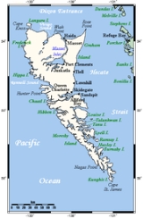
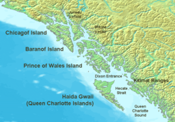
Haida Gwaii formerly the Queen Charlotte Islands, is an archipelago
on the North Coast
of British Columbia
, Canada
. Haida Gwaii consists of two main islands: Graham Island
in the north, and Moresby Island
in the south, along with approximately 150 smaller islands with a total landmass of 10180 km² (3,931 sq mi). Other major islands include Anthony
, Langara
, Louise
, Lyell
, Burnaby
, and Kunghit Island
s.
The islands are separated from the British Columbia mainland to the east by Hecate Strait
. Vancouver Island
lies to the south, across Queen Charlotte Sound, while the U.S. state
of Alaska
is to the north, across a marine border Dixon Entrance
disputed by two Nation state claimants, Canada and the USA. Haida territories, continuously occupied before Canada or USA claims, include lands and waters on both side of this political disagreement. There is no evidence of a free informed prior legal transfer of competence over these territories from the Indigenous Peoples to either Nation state.
In the Haida Gwaii archipelago all lands and waters are subject to the policies and jurisdiction of the Haida Nation. Additionally some of the islands are protected under Canada federal legislation as Gwaii Haanas National Park Reserve and Haida Heritage Site
, which is mostly Moresby Island and adjoining islands and islets (Gwaii Haanas is the Haida name for Moresby Island). In all these instances the Haida Nation has pre established protected status and subsequently agreed to the limited Canadian jurisdictional declarations. The foundation document that permits this to occur without prejudice to the underlying issues of sovereign jurisdiction is the Gwaii Haanas Agreement which recognizes the dual presence of two governmental structures.
Also protected, but under provincial legislation, are several parks, the largest of which is Naikoon Provincial Park
on northeastern Graham Island. The islands are home to an abundance of wildlife, including the largest subspecies of black bear, and also the smallest subspecies
(Ursus americana carlottae) and the subspecies of stoat
Mustela erminea haidarum. Black-tailed deer
and raccoon are introduced species that have become abundant.
On June 3, 2010, the Haida Gwaii Reconciliation Act officially renamed the islands Haida Gwaii as part of a reconciliation protocol between British Columbia and the Haida Nation.
and commercial fishing
. Furthermore, service industries and government jobs provide about one-third of the jobs, and tourism has become a more prominent part of the economy in recent years, especially for fishing and tour guide
s, cycling, camping, and adventure tourism.
The custom economy which is mostly a Haida cashless system and depends upon access to the marine and terrestrial ecoystems includes a robust potlatch structure and a complex and active system of intellectual and incorporeal values.
; other diseases arrived as well, including typhoid, measles
, and syphilis
, affecting many more inhabitants. By 1900, only 350 people remained. Towns were abandoned as people left their homes for the winter towns of Klinkwan (Alaska), Skidegate and Masset, cannery towns on the mainland, or for more urbanized centers in the US and Canada. Today, only some 3,800 Haida citizens live on the islands. About 70% of these Indigenous Peoples live in two communities at Skidegate
and Old Massett, with a population of about 1500 each. Citizens also reside throughout rural and urban centers in Alaska, Washington State and British Columbia.
Anthony Island
and the island of Ninstints
were made a UNESCO World Heritage Site in 2006; in the decision, the decline in population wrought by disease was referenced when citing the 'vanished civilization' of the Haida.
. Haida narratives note that early contacts were made with Buddhist monks. The name Massett is also the result of earlier contacts and assistance given to Spanish ships perhaps as early as the 16th century.
 In 1787 the islands were surveyed by Captain George Dixon. They were named the Queen Charlotte Islands by Captain Dixon after one of his ships, the Queen Charlotte, which was named after Queen Charlotte
, wife of King George III of the United Kingdom
.
The name Haida Gwaii is of modern coinage and was created in the early 1980s as an alternative to the colonial-era name "Queen Charlotte Islands", to recognize the history of the Haida people. "Haida Gwaii" means "islands of the people", while "Haida" on its own means not only "us" but also "people". On December 11, 2009, the BC government announced that legislation would be introduced in mid-2010 to officially rename the Queen Charlotte Islands as Haida Gwaii. The legislation received Royal assent on June 3, 2010, formalizing the name change. This name change is officially recognized by all levels of Canadian governments, including international name databases.
Still in use is the older name 'Xaadala Gwayee' or, in alternative orthography
, 'Xhaaidlagha Gwaayaai', meaning "islands on the Boundary of the world". Xhaaydla, 'Worlds' referring here to the sea and sky. A parallel name to Queen Charlotte Islands used by American traders, who considered the islands part of the US-claimed Oregon Country
, was Washington's Isles.
glaciation
receded from the archipelago about 16,000 BCE, about 2,000 years earlier than the rest of the British Columbia Coast's ice age. That, and its subsequent isolation from the mainland, encouraged Haida and environmental activists in the 1970s to use the term "Galápagos
of the North", a unique biocultural zone with many endemic kinds of plants and animals. The climate of this temperate north hemisphere forested region, like that of much of the British Columbia and Alaskan coast in the area, is moderated by the North Pacific Current
, with heavy rainfall and relatively mild temperatures throughout the year.
The islands are home to a wide variety of large endemic trees, including the Sitka spruce
, western red cedar, yellow cedar (Nootka cypress), shore pine
, western hemlock
, mountain hemlock
, and red alder
. The Flora of the Queen Charlotte Islands describes plants known from the islands.
Kiidk'yaas
(The Golden Spruce), a naturally occurring genetic-variant
yellow-coloured Sitka spruce tree, was located near the Yakoun River
, the largest on Graham Island. It was a popular tourist attraction until it was illegally cut down in 1997 as a protest against the BC legally sanctioned industrial logging practices.
For a very short time a popular attraction for tourists to the islands was the second appearance of a White Raven. This was an albino raven with unusual colouring. The White Raven lived around Port Clements and would commonly be seen taking food handouts from locals and visitors alike. It died after making contact with an electrical transformer. In 1985 as the Haida Nation prepared for its significant and ultimately successful challenge to Canadian jurisdictional claims over the forest a "White Raven" appeared in Old Massett. The White Raven is a potent cultural icon representing a fundamental transformative force and its appearance was a positive sign for the Haida Nation. This bird disappeared the same winter that the blockades of the logging roads in Lyell Island took place.
, an active transform fault
that produces significant earthquakes every 3–30 years. The fault is the underwater meeting of the Pacific
and North American Plate
s along the archipelago's west coast. The most recent earthquakes were on Nov 17th 2009.
(Cfb) in the south to subpolar oceanic (Cfc) in the north. Temperatures are moderate year round, whilst rainfall is generally heavy especially in the autumn months, when in the most exposed southwestern areas near Tasu
daily rainfalls as high as 317 millimetres (12.5 in) have been recorded, and the annual rainfalls are among the highest in the world outside the tropics. Even in the relatively shielded areas around Tlell
and Sandspit
annual rainfall averages from 1200 millimetres (47.2 in) to 1400 millimetres (55.1 in). Snowfall is generally moderate, averaging from 10 centimetres (3.9 in) to 70 centimetres (27.6 in), though at northerly Langara Island
it averages around 100 centimetres (39.4 in). Precipitation is typically extremely frequent, occurring on around two-thirds of all days even in relatively shielded areas, and sunshine is scarce, averaging around 3 to 4 hours per day.
, by Bill Reid
, is featured on the reverse of the Canadian $20 bill. It depicts a Haida Chief in a canoe, accompanied by the mythic messengers Raven, Frog and Eagle (the first casting of this sculpture, Spirit of Haida Gwaii: The Black Canoe, is on display in the atrium of the Canadian Embassy in Washington DC, the other, Spirit of Haida Gwaii: the Jade Canoe, is on display in Vancouver Airport). Haida art is also frequently seen on large monumental sized cedar totem poles and dugout canoes, hand-crafted gold and silver jewellery, and even as cartoons in the form of Haida Manga
.
was proposed for classification as part of the Nadene family of languages on the basis of a few similarities with Athabaskan–Eyak–Tlingit. Many linguists, however, consider the evidence insufficient and continue to regard Haida as a language isolate
. All 50 remaining speakers of Haida are over 70 years old. Telus
and Gwaii Trust recently completed a project to bring broadband internet to the island via a 150 km (93.2 mi) microwave relay. This enables interactive research to be carried out on the more than 80 CDs of language, story and spoken history of the people.
, the Masset Airport
and the BC Ferries
terminal at Skidegate. The westernmost leg of Highway 16 connects Masset and Skidegate on Graham Island, and Skidegate with Prince Rupert
on the mainland via regular BC Ferries service by the MV Northern Adventure
. There is also regular BC Ferries service between Skidegate and Alliford Bay on Moresby Island. Floatplane services connect to facilities such as the Alliford Bay Water Aerodrome
and Masset Water Aerodrome
.
Archipelago
An archipelago , sometimes called an island group, is a chain or cluster of islands. The word archipelago is derived from the Greek ἄρχι- – arkhi- and πέλαγος – pélagos through the Italian arcipelago...
on the North Coast
British Columbia Coast
The British Columbia Coast or BC Coast is Canada's western continental coastline on the Pacific Ocean. The usage is synonymous with the term West Coast of Canada....
of British Columbia
British Columbia
British Columbia is the westernmost of Canada's provinces and is known for its natural beauty, as reflected in its Latin motto, Splendor sine occasu . Its name was chosen by Queen Victoria in 1858...
, Canada
Canada
Canada is a North American country consisting of ten provinces and three territories. Located in the northern part of the continent, it extends from the Atlantic Ocean in the east to the Pacific Ocean in the west, and northward into the Arctic Ocean...
. Haida Gwaii consists of two main islands: Graham Island
Graham Island
Graham Island is the largest island in the Haida Gwaii archipelago , lying off the coast of British Columbia, Canada. It is separated only by a narrow channel from the other principal island of the group, Moresby Island Graham Island is the largest island in the Haida Gwaii archipelago (formerly...
in the north, and Moresby Island
Moresby Island
Moresby Island is a large island that forms part of the Haida Gwaii archipelago in British Columbia, Canada, located at . Gwaii Haanas National Park Reserve and Haida Heritage Site includes Moresby and other islands...
in the south, along with approximately 150 smaller islands with a total landmass of 10180 km² (3,931 sq mi). Other major islands include Anthony
Anthony Island (British Columbia)
Anthony Island is an island located in the southernmost Queen Charlotte Islands of the North Coast of British Columbia, Canada, to the west of Kunghit Island, the archipelago's southernmost. Anthony Island is noted for being the location of the ruins of SkungWai or SG̱ang Gwaay Llnaagay, commonly...
, Langara
Langara Island
Langara Island is the northernmost Island of the Queen Charlotte Islands in British Columbia, Canada. The island is approximately in size. It is located approximately south of Alaska.-History:...
, Louise
Louise Island
Louise Island is a island in the Queen Charlotte Islands, in British Columbia, Canada, off the east coast of Moresby Island. It was named for Princess Louise, Duchess of Argyll, fourth daughter of Queen Victoria...
, Lyell
Lyell Island
Lyell Island, known also in the Haida language as Athili Gwaii, is a large island in the Queen Charlotte Islands archipelago on the North Coast of British Columbia, Canada. The island is a part of the Gwaii Haanas National Park Reserve and Haida Heritage Site and had been the focus of anti-logging...
, Burnaby
Burnaby Island
Burnaby Island is an island in Haida Gwaii off the north coast of British Columbia, Canada, located off the southeast coast of Moresby Island. It is part of the Gwaii Haanas National Park Reserve and Haida Heritage Site....
, and Kunghit Island
Kunghit Island
Kunghit Island is an island in the Canadian province of British Columbia. It is the southernmost island in the Haida Gwaii archipelago, located to the south of Moresby Island. The southernmost point of Kunghit Island, called Cape St James, is used to delineated the boundary between Hecate Strait...
s.
The islands are separated from the British Columbia mainland to the east by Hecate Strait
Hecate Strait
Hecate Strait is a wide but shallow strait between the Haida Gwaii and the mainland of British Columbia, Canada. It merges with Queen Charlotte Sound to the south and Dixon Entrance to the north...
. Vancouver Island
Vancouver Island
Vancouver Island is a large island in British Columbia, Canada. It is one of several North American locations named after George Vancouver, the British Royal Navy officer who explored the Pacific Northwest coast of North America between 1791 and 1794...
lies to the south, across Queen Charlotte Sound, while the U.S. state
U.S. state
A U.S. state is any one of the 50 federated states of the United States of America that share sovereignty with the federal government. Because of this shared sovereignty, an American is a citizen both of the federal entity and of his or her state of domicile. Four states use the official title of...
of Alaska
Alaska
Alaska is the largest state in the United States by area. It is situated in the northwest extremity of the North American continent, with Canada to the east, the Arctic Ocean to the north, and the Pacific Ocean to the west and south, with Russia further west across the Bering Strait...
is to the north, across a marine border Dixon Entrance
Dixon Entrance
The Dixon Entrance is a strait about long and wide in the Pacific Ocean at the International Boundary between the U.S. state of Alaska and the province of British Columbia in Canada. It was named by Joseph Banks for Captain George Dixon, a Royal Navy officer, fur trader, and explorer, who...
disputed by two Nation state claimants, Canada and the USA. Haida territories, continuously occupied before Canada or USA claims, include lands and waters on both side of this political disagreement. There is no evidence of a free informed prior legal transfer of competence over these territories from the Indigenous Peoples to either Nation state.
In the Haida Gwaii archipelago all lands and waters are subject to the policies and jurisdiction of the Haida Nation. Additionally some of the islands are protected under Canada federal legislation as Gwaii Haanas National Park Reserve and Haida Heritage Site
Gwaii Haanas National Park Reserve and Haida Heritage Site
Ninstints or SGang Gwaay Llnaagay on Anthony Island, in located in the southernmost part of Gwaii Haanas, just west of Kunghit Island, was declared a UNESCO World Heritage Site in 1981...
, which is mostly Moresby Island and adjoining islands and islets (Gwaii Haanas is the Haida name for Moresby Island). In all these instances the Haida Nation has pre established protected status and subsequently agreed to the limited Canadian jurisdictional declarations. The foundation document that permits this to occur without prejudice to the underlying issues of sovereign jurisdiction is the Gwaii Haanas Agreement which recognizes the dual presence of two governmental structures.
Also protected, but under provincial legislation, are several parks, the largest of which is Naikoon Provincial Park
Naikoon Provincial Park
Naikoon Provincial Park is a provincial park on Graham Island in the Haida Gwaii archipelago, British Columbia, Canada. It is the ancestral home of the Gwak'rala'chala people, one of the many tribes that form the native group Haida...
on northeastern Graham Island. The islands are home to an abundance of wildlife, including the largest subspecies of black bear, and also the smallest subspecies
American black bear
The American black bear is a medium-sized bear native to North America. It is the continent's smallest and most common bear species. Black bears are omnivores, with their diets varying greatly depending on season and location. They typically live in largely forested areas, but do leave forests in...
(Ursus americana carlottae) and the subspecies of stoat
Stoat
The stoat , also known as the ermine or short-tailed weasel, is a species of Mustelid native to Eurasia and North America, distinguished from the least weasel by its larger size and longer tail with a prominent black tip...
Mustela erminea haidarum. Black-tailed deer
Black-tailed Deer
Two forms of black-tailed deer or blacktail deer occupying coastal temperate rainforest on North America's Pacific coast are subspecies of the mule deer. They have sometimes been treated as a species, but virtually all recent authorities maintain they are subspecies...
and raccoon are introduced species that have become abundant.
On June 3, 2010, the Haida Gwaii Reconciliation Act officially renamed the islands Haida Gwaii as part of a reconciliation protocol between British Columbia and the Haida Nation.
Economy
The cash based economy is blended, including Art and natural resources, primarily loggingLogging
Logging is the cutting, skidding, on-site processing, and loading of trees or logs onto trucks.In forestry, the term logging is sometimes used in a narrow sense concerning the logistics of moving wood from the stump to somewhere outside the forest, usually a sawmill or a lumber yard...
and commercial fishing
Commercial fishing
Commercial fishing is the activity of catching fish and other seafood for commercial profit, mostly from wild fisheries. It provides a large quantity of food to many countries around the world, but those who practice it as an industry must often pursue fish far into the ocean under adverse conditions...
. Furthermore, service industries and government jobs provide about one-third of the jobs, and tourism has become a more prominent part of the economy in recent years, especially for fishing and tour guide
Tour guide
A tour guide provides assistance, information and cultural, historical and contemporary heritage interpretation to people on organized tours, individual clients, educational establishments, at religious and historical sites, museums, and at venues of other significant interest...
s, cycling, camping, and adventure tourism.
The custom economy which is mostly a Haida cashless system and depends upon access to the marine and terrestrial ecoystems includes a robust potlatch structure and a complex and active system of intellectual and incorporeal values.
Population
At the time of early Canadian colonial contact, the population was estimated to be one of the highest concentrations of hunter gatherer societies in the world. A lower estimate would be roughly 10,000 people, residing in several full season and seasonal regionally influential towns and smaller settlements all with a carefully structured relationship to area marine and terrestrial "resources". The Haida were a slaving Peoples with populations drawn primarily from other regional Peoples. Ninety percent of the population died during the 1800s from smallpoxSmallpox
Smallpox was an infectious disease unique to humans, caused by either of two virus variants, Variola major and Variola minor. The disease is also known by the Latin names Variola or Variola vera, which is a derivative of the Latin varius, meaning "spotted", or varus, meaning "pimple"...
; other diseases arrived as well, including typhoid, measles
Measles
Measles, also known as rubeola or morbilli, is an infection of the respiratory system caused by a virus, specifically a paramyxovirus of the genus Morbillivirus. Morbilliviruses, like other paramyxoviruses, are enveloped, single-stranded, negative-sense RNA viruses...
, and syphilis
Syphilis
Syphilis is a sexually transmitted infection caused by the spirochete bacterium Treponema pallidum subspecies pallidum. The primary route of transmission is through sexual contact; however, it may also be transmitted from mother to fetus during pregnancy or at birth, resulting in congenital syphilis...
, affecting many more inhabitants. By 1900, only 350 people remained. Towns were abandoned as people left their homes for the winter towns of Klinkwan (Alaska), Skidegate and Masset, cannery towns on the mainland, or for more urbanized centers in the US and Canada. Today, only some 3,800 Haida citizens live on the islands. About 70% of these Indigenous Peoples live in two communities at Skidegate
Skidegate
Skidegate is a Haida community in Haida Gwaii in British Columbia, Canada. It is located on the southeast coast of Graham Island, the largest island in the archipelago, and is approximately west of mainland British Columbia across Hecate Strait...
and Old Massett, with a population of about 1500 each. Citizens also reside throughout rural and urban centers in Alaska, Washington State and British Columbia.
Anthony Island
Gwaii Haanas National Park Reserve and Haida Heritage Site
Ninstints or SGang Gwaay Llnaagay on Anthony Island, in located in the southernmost part of Gwaii Haanas, just west of Kunghit Island, was declared a UNESCO World Heritage Site in 1981...
and the island of Ninstints
Ninstints
Ninstints is the usual name in English for SGang Gwaay Llanagaay , a village site of the Haida people and part of the Gwaii Haanas National Park Reserve and Haida Heritage Site in Haida Gwaii on the North Coast of British Columbia, Canada...
were made a UNESCO World Heritage Site in 2006; in the decision, the decline in population wrought by disease was referenced when citing the 'vanished civilization' of the Haida.
History
The archipelago was visited in 1774 by Juan Pérez (at Langara Island) and in 1778 by Captain James CookJames Cook
Captain James Cook, FRS, RN was a British explorer, navigator and cartographer who ultimately rose to the rank of captain in the Royal Navy...
. Haida narratives note that early contacts were made with Buddhist monks. The name Massett is also the result of earlier contacts and assistance given to Spanish ships perhaps as early as the 16th century.
Naming
Charlotte of Mecklenburg-Strelitz
Charlotte of Mecklenburg-Strelitz was the Queen consort of the United Kingdom as the wife of King George III...
, wife of King George III of the United Kingdom
George III of the United Kingdom
George III was King of Great Britain and King of Ireland from 25 October 1760 until the union of these two countries on 1 January 1801, after which he was King of the United Kingdom of Great Britain and Ireland until his death...
.
The name Haida Gwaii is of modern coinage and was created in the early 1980s as an alternative to the colonial-era name "Queen Charlotte Islands", to recognize the history of the Haida people. "Haida Gwaii" means "islands of the people", while "Haida" on its own means not only "us" but also "people". On December 11, 2009, the BC government announced that legislation would be introduced in mid-2010 to officially rename the Queen Charlotte Islands as Haida Gwaii. The legislation received Royal assent on June 3, 2010, formalizing the name change. This name change is officially recognized by all levels of Canadian governments, including international name databases.
Still in use is the older name 'Xaadala Gwayee' or, in alternative orthography
Orthography
The orthography of a language specifies a standardized way of using a specific writing system to write the language. Where more than one writing system is used for a language, for example Kurdish, Uyghur, Serbian or Inuktitut, there can be more than one orthography...
, 'Xhaaidlagha Gwaayaai', meaning "islands on the Boundary of the world". Xhaaydla, 'Worlds' referring here to the sea and sky. A parallel name to Queen Charlotte Islands used by American traders, who considered the islands part of the US-claimed Oregon Country
Oregon Country
The Oregon Country was a predominantly American term referring to a disputed ownership region of the Pacific Northwest of North America. The region was occupied by British and French Canadian fur traders from before 1810, and American settlers from the mid-1830s, with its coastal areas north from...
, was Washington's Isles.
Environment
The last PleistocenePleistocene
The Pleistocene is the epoch from 2,588,000 to 11,700 years BP that spans the world's recent period of repeated glaciations. The name pleistocene is derived from the Greek and ....
glaciation
Ice age
An ice age or, more precisely, glacial age, is a generic geological period of long-term reduction in the temperature of the Earth's surface and atmosphere, resulting in the presence or expansion of continental ice sheets, polar ice sheets and alpine glaciers...
receded from the archipelago about 16,000 BCE, about 2,000 years earlier than the rest of the British Columbia Coast's ice age. That, and its subsequent isolation from the mainland, encouraged Haida and environmental activists in the 1970s to use the term "Galápagos
Galápagos Islands
The Galápagos Islands are an archipelago of volcanic islands distributed around the equator in the Pacific Ocean, west of continental Ecuador, of which they are a part.The Galápagos Islands and its surrounding waters form an Ecuadorian province, a national park, and a...
of the North", a unique biocultural zone with many endemic kinds of plants and animals. The climate of this temperate north hemisphere forested region, like that of much of the British Columbia and Alaskan coast in the area, is moderated by the North Pacific Current
North Pacific Current
The North Pacific Current is a slow warm water current that flows west-to-east between 40 and 50 degrees north in the Pacific Ocean. The current forms the southern part of the North Pacific Subpolar Gyre...
, with heavy rainfall and relatively mild temperatures throughout the year.
The islands are home to a wide variety of large endemic trees, including the Sitka spruce
Sitka Spruce
Picea sitchensis, the Sitka Spruce, is a large coniferous evergreen tree growing to 50–70 m tall, exceptionally to 95 m tall, and with a trunk diameter of up to 5 m, exceptionally to 6–7 m diameter...
, western red cedar, yellow cedar (Nootka cypress), shore pine
Lodgepole Pine
Lodgepole Pine, Pinus contorta, also known as Shore Pine, is a common tree in western North America. Like all pines, it is evergreen.-Subspecies:...
, western hemlock
Western Hemlock
Tsuga heterophylla. the Western Hemlock, is a species of hemlock native to the west coast of North America, with its northwestern limit on the Kenai Peninsula, Alaska, and its southeastern limit in northern Sonoma County, California.-Habitat:...
, mountain hemlock
Mountain Hemlock
Tsuga mertensiana, known as Mountain Hemlock, is a species of hemlock native to the west coast of North America, with its northwestern limit on the Kenai Peninsula, Alaska, and its southeastern limit in northern Tulare County, California....
, and red alder
Red Alder
Alnus rubra, the Red alder, is a deciduous broadleaf tree native to western North America.-Description:It is the largest species of alder in North America and one of the largest in the world, reaching heights of 20–35 m. The official tallest red alder stands 32 meters tall in Clatsop County, Oregon...
. The Flora of the Queen Charlotte Islands describes plants known from the islands.
Kiidk'yaas
Kiidk'yaas
Kiidk'yaas, also known as the Golden Spruce, was a Sitka Spruce tree, Picea sitchensis 'Aurea', that grew on the banks of the Yakoun River in Haida Gwaii archipelago, British Columbia...
(The Golden Spruce), a naturally occurring genetic-variant
Mutation
In molecular biology and genetics, mutations are changes in a genomic sequence: the DNA sequence of a cell's genome or the DNA or RNA sequence of a virus. They can be defined as sudden and spontaneous changes in the cell. Mutations are caused by radiation, viruses, transposons and mutagenic...
yellow-coloured Sitka spruce tree, was located near the Yakoun River
Yakoun River
The Yakoun River is the largest river on Haida Gwaii, off the North Coast of British Columbia, Canada. Estimated to be in length, it is located on Graham Island, the northernmost and largest of the archipelago, and runs in a twisting course generally northwards from Yakoun Lake, which lies near...
, the largest on Graham Island. It was a popular tourist attraction until it was illegally cut down in 1997 as a protest against the BC legally sanctioned industrial logging practices.
For a very short time a popular attraction for tourists to the islands was the second appearance of a White Raven. This was an albino raven with unusual colouring. The White Raven lived around Port Clements and would commonly be seen taking food handouts from locals and visitors alike. It died after making contact with an electrical transformer. In 1985 as the Haida Nation prepared for its significant and ultimately successful challenge to Canadian jurisdictional claims over the forest a "White Raven" appeared in Old Massett. The White Raven is a potent cultural icon representing a fundamental transformative force and its appearance was a positive sign for the Haida Nation. This bird disappeared the same winter that the blockades of the logging roads in Lyell Island took place.
Earthquake hazards
The islands are located along the Queen Charlotte FaultQueen Charlotte Fault
The Queen Charlotte Fault is an active transform fault, located between the North American Plate and the Pacific Plate, Canada's equivalent of the San Andreas Fault. The Queen Charlotte Fault forms a triple junction on its south with the Cascadia subduction zone and the Explorer Ridge...
, an active transform fault
Transform fault
A transform fault or transform boundary, also known as conservative plate boundary since these faults neither create nor destroy lithosphere, is a type of fault whose relative motion is predominantly horizontal in either sinistral or dextral direction. Furthermore, transform faults end abruptly...
that produces significant earthquakes every 3–30 years. The fault is the underwater meeting of the Pacific
Pacific Plate
The Pacific Plate is an oceanic tectonic plate that lies beneath the Pacific Ocean. At 103 million square kilometres, it is the largest tectonic plate....
and North American Plate
North American Plate
The North American Plate is a tectonic plate covering most of North America, Greenland, Cuba, Bahamas, and parts of Siberia, Japan and Iceland. It extends eastward to the Mid-Atlantic Ridge and westward to the Chersky Range in eastern Siberia. The plate includes both continental and oceanic crust...
s along the archipelago's west coast. The most recent earthquakes were on Nov 17th 2009.
Climate
The climate ranges from oceanicOceanic climate
An oceanic climate, also called marine west coast climate, maritime climate, Cascadian climate and British climate for Köppen climate classification Cfb and subtropical highland for Köppen Cfb or Cwb, is a type of climate typically found along the west coasts at the middle latitudes of some of the...
(Cfb) in the south to subpolar oceanic (Cfc) in the north. Temperatures are moderate year round, whilst rainfall is generally heavy especially in the autumn months, when in the most exposed southwestern areas near Tasu
Tasu, British Columbia
Tasu or Tassoo, also Old Tasu or Old Tasu Townsite, was an iron and copper -open pit and underground mining operation and townsite located on the south shore of Tasu Sound in west-central Moresby Island in the Queen Charlotte Islands of the North Coast of British Columbia, Canada.The Phyllis...
daily rainfalls as high as 317 millimetres (12.5 in) have been recorded, and the annual rainfalls are among the highest in the world outside the tropics. Even in the relatively shielded areas around Tlell
Tlell, British Columbia
Tlell is a small, unincorporated place on the east coast of Graham Island, which is part of Haida Gwaii in British Columbia, Canada.-History:...
and Sandspit
Sandspit, British Columbia
Sandspit is the largest community on Moresby Island, in Haida Gwaii off the Pacific coast of British Columbia, Canada. The unincorporated community had a population of 538 persons as of the 2001 census...
annual rainfall averages from 1200 millimetres (47.2 in) to 1400 millimetres (55.1 in). Snowfall is generally moderate, averaging from 10 centimetres (3.9 in) to 70 centimetres (27.6 in), though at northerly Langara Island
Langara Island
Langara Island is the northernmost Island of the Queen Charlotte Islands in British Columbia, Canada. The island is approximately in size. It is located approximately south of Alaska.-History:...
it averages around 100 centimetres (39.4 in). Precipitation is typically extremely frequent, occurring on around two-thirds of all days even in relatively shielded areas, and sunshine is scarce, averaging around 3 to 4 hours per day.
Culture
Visual arts
The artwork known as Spirit of Haida GwaiiSpirit of Haida Gwaii
The Spirit of Haida Gwaii is a sculpture by British Columbia Haida artist Bill Reid . It is featured on the Canadian $20 bill. -Background:...
, by Bill Reid
Bill Reid
William Ronald Reid, OBC was a Canadian artist whose works included jewelry, sculpture, screen-printing, and painting. His work is featured on the Canadian $20 banknote.-Biography:...
, is featured on the reverse of the Canadian $20 bill. It depicts a Haida Chief in a canoe, accompanied by the mythic messengers Raven, Frog and Eagle (the first casting of this sculpture, Spirit of Haida Gwaii: The Black Canoe, is on display in the atrium of the Canadian Embassy in Washington DC, the other, Spirit of Haida Gwaii: the Jade Canoe, is on display in Vancouver Airport). Haida art is also frequently seen on large monumental sized cedar totem poles and dugout canoes, hand-crafted gold and silver jewellery, and even as cartoons in the form of Haida Manga
Haida Manga
Haida Manga is a new style of Haida comics and print cartoons that explores the elements of both traditional North Pacific indigenous arts and narrative, while also adapting contemporary techniques of artistic design from the Eastern portion of the North Pacific, namely the Japanese manga from...
.
Haida language
The Haida languageHaida language
The Haida language is the language of the Haida people. It contains seven vowels and well over 30 consonants.-History:The first documented contact between the Haida and Europeans was in 1774, on Juan Pérez's exploratory voyage. At this time Haidas inhabited the Queen Charlotte Islands, Dall...
was proposed for classification as part of the Nadene family of languages on the basis of a few similarities with Athabaskan–Eyak–Tlingit. Many linguists, however, consider the evidence insufficient and continue to regard Haida as a language isolate
Language isolate
A language isolate, in the absolute sense, is a natural language with no demonstrable genealogical relationship with other languages; that is, one that has not been demonstrated to descend from an ancestor common with any other language. They are in effect language families consisting of a single...
. All 50 remaining speakers of Haida are over 70 years old. Telus
TELUS
Telus is a national telecommunications company in Canada that provides a wide range of telecommunications products and services including internet access, voice, entertainment, video, and satellite television. The company is based in Burnaby, British Columbia, part of Greater Vancouver...
and Gwaii Trust recently completed a project to bring broadband internet to the island via a 150 km (93.2 mi) microwave relay. This enables interactive research to be carried out on the more than 80 CDs of language, story and spoken history of the people.
Transportation
The main transportation links between the Islands and the continent are to the mainland of British Columbia through the Sandspit AirportSandspit Airport
Sandspit Airport, , is located northeast of Sandspit, British Columbia, Canada.-Airlines and destinations:...
, the Masset Airport
Masset Airport
Masset Airport, , is located northeast of Masset, British Columbia, Canada.-Airlines and destinations:...
and the BC Ferries
BC Ferries
British Columbia Ferry Services Inc. or BC Ferries is a de facto Crown Corporation that provides all major passenger and vehicle ferry services for coastal and island communities in the Canadian province of British Columbia...
terminal at Skidegate. The westernmost leg of Highway 16 connects Masset and Skidegate on Graham Island, and Skidegate with Prince Rupert
Prince Rupert, British Columbia
Prince Rupert is a port city in the province of British Columbia, Canada. It is the land, air, and water transportation hub of British Columbia's North Coast, and home to some 12,815 people .-History:...
on the mainland via regular BC Ferries service by the MV Northern Adventure
MV Northern Adventure
M/V Northern Adventure is a RORO ferry operated by BC Ferries. It sails two routes: the scenic Inside Passage route between Port Hardy and Prince Rupert and the Queen Charlotte Island crossing between Prince Rupert and Skidegate.-History:...
. There is also regular BC Ferries service between Skidegate and Alliford Bay on Moresby Island. Floatplane services connect to facilities such as the Alliford Bay Water Aerodrome
Alliford Bay Water Aerodrome
Alliford Bay Water Aerodrome, , is located on Alliford Bay, British Columbia, Canada. Alliford Bay is a part of Skidegate Inlet, Moresby Island in the Queen Charlotte Islands....
and Masset Water Aerodrome
Masset Water Aerodrome
Masset Water Aerodrome, , is located adjacent to Masset, British Columbia, Canada.The airport is classified as an airport of entry by NAV CANADA and is staffed by the Canada Border Services Agency. CBSA officers at this airport currently can handle general aviation aircraft only, with no more than...
.