

El Tatio
Encyclopedia
Geyser
A geyser is a spring characterized by intermittent discharge of water ejected turbulently and accompanied by a vapour phase . The word geyser comes from Geysir, the name of an erupting spring at Haukadalur, Iceland; that name, in turn, comes from the Icelandic verb geysa, "to gush", the verb...
field located within the Andes
Andes
The Andes is the world's longest continental mountain range. It is a continual range of highlands along the western coast of South America. This range is about long, about to wide , and of an average height of about .Along its length, the Andes is split into several ranges, which are separated...
Mountains of northern Chile
Norte Grande, Chile
The Norte Grande is one of the five natural regions into which CORFO divided continental Chile in 1950. It borders Peru to the north, the Pacific Ocean to the west, the Altiplano, Bolivia and Argentina to the east, and the Copiapó River to the south, beyond which lies the Norte Chico natural...
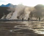
at 4,200 meters above mean sea level. Contrary to some reports, it is not the highest-elevation geyser field in the world. Puchuldiza Geyser Field, Chile, and possibly several other fields are higher in elevation (Glennon, J.A. and Pfaff, R.M., 2003). Tourists often visit the geysers while touring the nearby Atacama Desert
Atacama Desert
The Atacama Desert is a plateau in South America, covering a strip of land on the Pacific coast, west of the Andes mountains. It is, according to NASA, National Geographic and many other publications, the driest desert in the world...
and the village San Pedro de Atacama
San Pedro de Atacama
San Pedro de Atacama is a Chilean town and commune in El Loa Province, Antofagasta Region. It is located east of Antofagasta, some 106 km southeast of Calama and the Chuquicamata copper mine, overlooking the Licancabur volcano. It features a significant archeological museum, the R. P...
. "With over 80 active geysers, El Tatio is the largest geyser field in the southern hemisphere and the third largest field in the world, after Yellowstone, USA, and Dolina Giezerov
Valley of Geysers
The Valley of Geysers is a geyser field in Russia, and has the second largest concentration of geysers in the world. This 6 km long basin with approximately ninety geysers and many hot springs is situated on the Kamchatka Peninsula in the Russian Far East, predominantly on the left bank of...
(partially destroyed June 2007), Russia
Russia
Russia or , officially known as both Russia and the Russian Federation , is a country in northern Eurasia. It is a federal semi-presidential republic, comprising 83 federal subjects...
" (Glennon, J.A. and Pfaff, R.M., 2003).
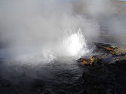
"Though possessing numerous geysers, none erupt very high. The highest eruption observed has been around six meters in height. The average geyser eruption height at El Tatio is about 75 centimeters" (Glennon, J.A. and Pfaff. R.M., 2003). The best time to see them is at sunrise when each geyser is surmounted by a column of steam that condenses in the bitterly cold morning air. The steam plumes disappear as the air warms up. It is also possible to bathe in the hot geyser water in a small pool. However parts of the field are very dangerous with a thin crust over almost boiling mud so ask your guide where you may go.
There is wreckage at the site from an old project for harnessing geothermal power. The idea has recently been revived by the Chilean government and is meeting with heavy public resistance due to the touristic value the geyser field represents.
"El Tatio" roughly translates to "the grandfather"." (Glennon, J.A. and Pfaff, R.M., 2003).
2009 prospection controversy
In mid-September 2009, a 200-foot permanent steam column was noticed. Further developments point to damage done by prospection by GDN, a geothermal exploitation company jointly owned by Chilean State holdings and an Italian Energy consortium. News clippingSee also
- Putana VolcanoPutana VolcanoPutana is a stratovolcano on the border between Bolivia and Chile. It lies immediately NNE of Cerro Colorado, about north of Volcán Escalante, the northernmost member of the Sairecabur complex and south of the Cerros de Tocorpuri complex...
- TocorpuriTocorpuriCerros de Tocorpuri is a volcanic complex located along the border between Bolivia and Chile. Cerros de Tocorpuri's summit crater has a diameter of 1.4 km....
- LinzorLinzorVolcán Linzor is a stratovolcano on the border between Bolivia and Chile. In its vicinity lie Laguna Colorada and Cerro del León....
- Cerro del LeónCerro del LeónCerro del León is a stratovolcano located in El Loa Province, Antofagasta Region, Chile. Chao dacitic lava dome separates it from Cerro Paniri, a stratovolcano, and to its east lies Chillahuita, another dacitic lava dome....
- Salado River