

Port Douglas, British Columbia
Encyclopedia
British Columbia
British Columbia is the westernmost of Canada's provinces and is known for its natural beauty, as reflected in its Latin motto, Splendor sine occasu . Its name was chosen by Queen Victoria in 1858...
, Canada
Canada
Canada is a North American country consisting of ten provinces and three territories. Located in the northern part of the continent, it extends from the Atlantic Ocean in the east to the Pacific Ocean in the west, and northward into the Arctic Ocean...
at the head of Harrison Lake
Harrison Lake
Harrison Lake is the largest lake in the southern Coast Mountains of Canada, being about 250 square kilometres in area. It is about 60 km in length and at its widest almost 9 km across. Its southern end, at the resort community of Harrison Hot Springs, is c. 95 km east of...
, which is the head of river navigation from the Strait of Georgia
Strait of Georgia
The Strait of Georgia or the Georgia Strait is a strait between Vancouver Island and the mainland coast of British Columbia, Canada. It is approximately long and varies in width from...
. Port Douglas was the second major settlement of any size on the British Columbia mainland (after Yale
Yale, British Columbia
Yale is an unincorporated town in the Canadian province of British Columbia. It was founded in 1848 by the Hudson's Bay Company as Fort Yale by Ovid Allard, the appointed manager of the new post, who named it after his superior, James Murray Yale, then Chief Factor of the Columbia District...
during the Fraser Canyon Gold Rush
Fraser Canyon Gold Rush
The Fraser Canyon Gold Rush, began in 1858 after gold was discovered on the Thompson River in British Columbia at its confluence with the Nicoamen River. This was a few miles upstream from the Thompson's confluence with the Fraser River at present-day Lytton...
.
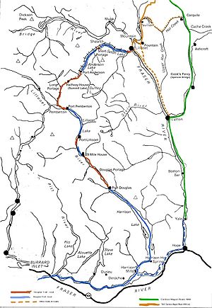
From Port Douglas to Lillooet
Lillooet, British Columbia
Lillooet is a community on the Fraser River in western Canada, about up the British Columbia Railway line from Vancouver. Situated at an intersection of deep gorges in the lee of the Coast Mountains, it has a dry climate- of precipitation is recorded annually at the town's weather station,...
a mixed land and water route was built named the Douglas Road
Douglas Road
The Douglas Road, aka the Lillooet Trail, Harrison Trail or Lakes Route, was a goldrush-era transportation route from the British Columbia Coast to the Interior...
, aka the Lillooet Trail, Harrison Trail or Lakes Route. During its rowdy heyday Port Douglas had thousands of residents and many of the BC mainland's first companies had their start here, including the famous B.X. Express and other major freighting companies, who relocated to the Fraser Canyon
Fraser Canyon
The Fraser Canyon is an 84 km landform of the Fraser River where it descends rapidly through narrow rock gorges in the Coast Mountains en route from the Interior Plateau of British Columbia to the Fraser Valley...
with the completion of the Cariboo Wagon Road in the mid-1860s.
Although Port Douglas dwindled in size rapidly with the abandonment of the Douglas Road
Douglas Road
The Douglas Road, aka the Lillooet Trail, Harrison Trail or Lakes Route, was a goldrush-era transportation route from the British Columbia Coast to the Interior...
and today there is nothing left - other than the placename and the adopted name of the local First Nation, the Douglas Band of the In-SHUCK-ch Nation
In-SHUCK-ch Nation
The In-SHUCK-ch Nation, also known as Lower Lillooet people, are a small First Nations Tribal Council on the lower Lillooet River south of Pemberton-Mount Currie in the Canadian province of British Columbia...
.
A land alienation pattern on the lakeshore to the southwest of Douglas, across the mouth of the Lillooet River
Lillooet River
The Lillooet River is a major river of the southern Coast Mountains of British Columbia. It begins at Silt Lake, on the southern edge of the Lillooet Crown Icecap about 80 kilometres northwest of Pemberton and about 85 kilometres northwest of Whistler...
and down the lake a bit, remains on the map as Tipella City (also known as Tipella, or Tipella Hot Springs). It was a port and land-promotion scheme from 1898 that never went far, although a number of investors and buyers were taken in by it. The port was a wharf for the Moneyspinner silver mine at Fire Lake which operated for a few years.
Regular steamboat
Steamboat
A steamboat or steamship, sometimes called a steamer, is a ship in which the primary method of propulsion is steam power, typically driving propellers or paddlewheels...
traffic to Port Douglas from Georgia Strait and New Westminster via the Fraser River
Fraser River
The Fraser River is the longest river within British Columbia, Canada, rising at Fraser Pass near Mount Robson in the Rocky Mountains and flowing for , into the Strait of Georgia at the city of Vancouver. It is the tenth longest river in Canada...
ended in the 1890s, although the town was long-dead by then, with only a handful of non-native residents. In the 1970s a large logging operation bulldozed the last remains of the town, which were only vestiges of a few foundations.
Both Port Douglas and the Douglas Road
Douglas Road
The Douglas Road, aka the Lillooet Trail, Harrison Trail or Lakes Route, was a goldrush-era transportation route from the British Columbia Coast to the Interior...
, as well as the Douglas Ranges
Douglas Ranges
The Douglas Ranges are a subrange of the Pacific Ranges of the Coast Mountains of the Canadian province of British Columbia, about 70 km east of downtown Vancouver, north of the Fraser River and between the valleys of Stave and Harrison Lakes. They are approximately 4900 km² in area...
to the west of Harrison Lake
Harrison Lake
Harrison Lake is the largest lake in the southern Coast Mountains of Canada, being about 250 square kilometres in area. It is about 60 km in length and at its widest almost 9 km across. Its southern end, at the resort community of Harrison Hot Springs, is c. 95 km east of...
, were named in honour of the first governor of the Colony of British Columbia
Colony of British Columbia
The Colony of British Columbia was a crown colony in British North America from 1858 until 1866. At its creation, it physically constituted approximately half the present day Canadian province of British Columbia, since it did not include the Colony of Vancouver Island, the vast and still largely...
, Sir James Douglas
James Douglas (Governor)
Sir James Douglas KCB was a company fur-trader and a British colonial governor on Vancouver Island in northwestern North America, particularly in what is now British Columbia. Douglas worked for the North West Company, and later for the Hudson's Bay Company becoming a high-ranking company officer...
.
See also
- Vessels of the Lakes RouteVessels of the Lakes RouteThe Lakes Route is an alternate name for the Douglas Road, which was the first formally-designated "road" into the Interior of British Columbia, Canada from its Lower Mainland area flanking the Lower Fraser River...