
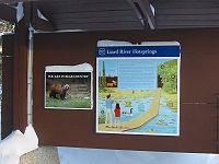
Liard River Hot Springs Provincial Park
Encyclopedia
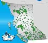
Liard River Hot Springs Provincial Park is a provincial park
in British Columbia
, Canada
. It is home to the second largest hot spring
in Canada. The park is part of the larger Muskwa-Kechika Management Area. The community of Liard River, British Columbia
is located nearby.
in 1942. The Liard River Hot Springs proper are located at 59°25′40"N 126°06′15"W. They were originally named the Theresa Hot Springs.
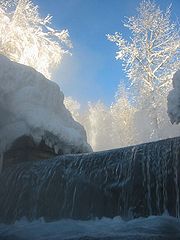
The park contains a warm water swamp and boreal forest which supports rich and diverse plant communities as well as mammal and bird species. Watch for moose
feeding in the warm water swamps. Bear
s, as well, are a common hazard in summer months, and may be feeding only 10 feet away from bathers. Due to the lush plant life (including 14 species of orchids) influenced by the warmth of the springs, the area was originally known as the "Tropical Valley".
 There are two hot springs with water temperatures ranging from 42°C to 52°C; the nearest is the Alpha pool. Beta pool is beyond Alpha and is larger, cooler and deeper.
There are raised walkways from the parking area to the springs so that the delicate muskeg
that forms the swamp is not disturbed. The walkway was the scene of a much-publicized black bear attack that killed two tourists on August 14, 1997. However, at least 50 bears were killed around the springs in 1998 to ease the public's concern.
The campground is open year-round.
, between Fort Nelson
(307 km south-east) and Watson Lake
(218 km north-west). The community of Liard River
is just west of the park, at the 499 Milepost.
Provincial park
A provincial park is a park under the management of a provincial or territorial government in Canada.While provincial parks are not the same as national parks, their workings are very similar...
in British Columbia
British Columbia
British Columbia is the westernmost of Canada's provinces and is known for its natural beauty, as reflected in its Latin motto, Splendor sine occasu . Its name was chosen by Queen Victoria in 1858...
, Canada
Canada
Canada is a North American country consisting of ten provinces and three territories. Located in the northern part of the continent, it extends from the Atlantic Ocean in the east to the Pacific Ocean in the west, and northward into the Arctic Ocean...
. It is home to the second largest hot spring
Hot spring
A hot spring is a spring that is produced by the emergence of geothermally heated groundwater from the Earth's crust. There are geothermal hot springs in many locations all over the crust of the earth.-Definitions:...
in Canada. The park is part of the larger Muskwa-Kechika Management Area. The community of Liard River, British Columbia
Liard River, British Columbia
Liard River is a small community in northern British Columbia, Canada. It has a population of about 100 people. It is located at Kilometre 799 of the Alaska Highway, near the border of British Columbia and the Yukon Territory....
is located nearby.
History and conservation
The Liard River Hot Springs Provincial Park was created in April 1957. The first boardwalk and pool facilities were built by the United States ArmyUnited States Army
The United States Army is the main branch of the United States Armed Forces responsible for land-based military operations. It is the largest and oldest established branch of the U.S. military, and is one of seven U.S. uniformed services...
in 1942. The Liard River Hot Springs proper are located at 59°25′40"N 126°06′15"W. They were originally named the Theresa Hot Springs.
The park contains a warm water swamp and boreal forest which supports rich and diverse plant communities as well as mammal and bird species. Watch for moose
Moose
The moose or Eurasian elk is the largest extant species in the deer family. Moose are distinguished by the palmate antlers of the males; other members of the family have antlers with a dendritic configuration...
feeding in the warm water swamps. Bear
Bear
Bears are mammals of the family Ursidae. Bears are classified as caniforms, or doglike carnivorans, with the pinnipeds being their closest living relatives. Although there are only eight living species of bear, they are widespread, appearing in a wide variety of habitats throughout the Northern...
s, as well, are a common hazard in summer months, and may be feeding only 10 feet away from bathers. Due to the lush plant life (including 14 species of orchids) influenced by the warmth of the springs, the area was originally known as the "Tropical Valley".
Recreation
There are raised walkways from the parking area to the springs so that the delicate muskeg
Muskeg
Muskeg is an acidic soil type common in Arctic and boreal areas, although it is found in other northern climates as well. Muskeg is approximately synonymous with bogland but muskeg is the standard term in Western Canada and Alaska, while 'bog' is common elsewhere. The term is of Cree origin, maskek...
that forms the swamp is not disturbed. The walkway was the scene of a much-publicized black bear attack that killed two tourists on August 14, 1997. However, at least 50 bears were killed around the springs in 1998 to ease the public's concern.
The campground is open year-round.
Amenities
- Bathing pools
- Change houses
- Wheelchair access
- Playground
- A 300m long wooden walkway leads from the parking lot to the hotsprings pool, crossing picturesque muskegMuskegMuskeg is an acidic soil type common in Arctic and boreal areas, although it is found in other northern climates as well. Muskeg is approximately synonymous with bogland but muskeg is the standard term in Western Canada and Alaska, while 'bog' is common elsewhere. The term is of Cree origin, maskek...
. - environmentally friendly composting outhouse
Nearby attractions
- A lodge with restaurant is located across the highway, the Liard Hot Springs Lodge.
- Muncho Lake Provincial ParkMuncho Lake Provincial ParkMuncho Lake Provincial Park is a provincial park in British Columbia, Canada, located on the Alaska Highway as it transits the northernmost Canadian Rockies west of Fort Nelson. The park is part of the larger Muskwa-Kechika Management Area....
is just 30 km south of the Liard Hotsprings. - Liard River Corridor Provincial Park and Protected AreaLiard River Corridor Provincial Park and Protected AreaLiard River Corridor Provincial Park and Protected Area is a provincial park in British Columbia, Canada. Part of the park is in the larger Muskwa-Kechika Management Area....
borders the park to the south.
Location
The park is located at mile 475 (or km 765) on the Alaska HighwayAlaska Highway
The Alaska Highway was constructed during World War II for the purpose of connecting the contiguous U.S. to Alaska through Canada. It begins at the junction with several Canadian highways in Dawson Creek, British Columbia and runs to Delta Junction, Alaska, via Whitehorse, Yukon...
, between Fort Nelson
Fort Nelson, British Columbia
Fort Nelson is a town of approximately 5000 residents in British Columbia's northeastern corner. It is the administrative centre of the newly formed Northern Rockies Regional Municipality, a first for BC. The majority of Fort Nelson's economic activities have historically been concentrated in the...
(307 km south-east) and Watson Lake
Watson Lake, Yukon
Watson Lake is a town at historical mile 635 on the Alaska Highway in the southeastern Yukon close to the British Columbia border. Population in December 2004 was 1,547 ....
(218 km north-west). The community of Liard River
Liard River, British Columbia
Liard River is a small community in northern British Columbia, Canada. It has a population of about 100 people. It is located at Kilometre 799 of the Alaska Highway, near the border of British Columbia and the Yukon Territory....
is just west of the park, at the 499 Milepost.
See also
- List of British Columbia Provincial Parks
- List of Canadian provincial parks
- List of National Parks of Canada
- Muncho Lake Provincial ParkMuncho Lake Provincial ParkMuncho Lake Provincial Park is a provincial park in British Columbia, Canada, located on the Alaska Highway as it transits the northernmost Canadian Rockies west of Fort Nelson. The park is part of the larger Muskwa-Kechika Management Area....
- Stone Mountain Provincial ParkStone Mountain Provincial ParkThe Stone Mountain Provincial Park is an area of 256.91 square kilometres of mountain wilderness in the Canadian province of British Columbia. The park is part of the larger Muskwa-Kechika Management Area which includes the Northern Rocky Mountains Provincial Park, immediately south, and Kwadacha...
- Toad River Hot Springs Provincial ParkToad River Hot Springs Provincial ParkToad River Hot Springs Provincial Park is a provincial park in British Columbia, Canada. The hotsprings is located on the lefthand bank of the Toad River, outside of the Racing River outflow. Access is via hiking, river boat, horseback, or helicopter. There is no actual bathing pool, so visitors...
External links
- Liard River Hot Springs Provincial Park - on BC Parks (Ministry of Environment) website