
Whitianga
Encyclopedia
Mercury Bay
Mercury Bay is a large V-shaped bay on the eastern coast of the Coromandel Peninsula on the North Island of New Zealand. This bay was named by the English navigator Captain James Cook during his exploratory expeditions. By the Māori it was named Te-Whanganui-o-Hei, the great bay of Hei.On November...
on the North Island
North Island
The North Island is one of the two main islands of New Zealand, separated from the much less populous South Island by Cook Strait. The island is in area, making it the world's 14th-largest island...
of New Zealand
New Zealand
New Zealand is an island country in the south-western Pacific Ocean comprising two main landmasses and numerous smaller islands. The country is situated some east of Australia across the Tasman Sea, and roughly south of the Pacific island nations of New Caledonia, Fiji, and Tonga...
. The population was 3768 in the 2006 Census, an increase of 690 from 2001. The population is now 4100 an increase of 332 since 2006.
Social
Since 2001 there has been an increased development of new commercial areas, as well as dwellings. Two distinct trends can be seen in the development of accommodation.- Apartments are being developed in several locations, many overlooking the harbour.
- A canal development has commenced providing a waterways environment, with houses being located along canals allowing marine access from the estuary.
- In October 2011 Whitianga became home to the Warehouse Limited, many big chain companies are expected to open shop in Whitianga as the town continues to rapidly develop.
Maori History
Whitianga has been continuously occupied for more than a thousand years since Maori explorer KupeKupe
In the Māori mythology of some tribes, Kupe was involved in the Polynesian discovery of New Zealand.-Contention:There is contention concerning the status of Kupe. The contention turns on the authenticity of later versions of the legends, the so-called 'orthodox' versions closely associated with S....
’s tribe settled here after his visit in about 950 AD. Following this visit, many of Kupe
Kupe
In the Māori mythology of some tribes, Kupe was involved in the Polynesian discovery of New Zealand.-Contention:There is contention concerning the status of Kupe. The contention turns on the authenticity of later versions of the legends, the so-called 'orthodox' versions closely associated with S....
's tribe settled here. Te Whitianga a Kupe is the original place name of the town, meaning Kupe
Kupe
In the Māori mythology of some tribes, Kupe was involved in the Polynesian discovery of New Zealand.-Contention:There is contention concerning the status of Kupe. The contention turns on the authenticity of later versions of the legends, the so-called 'orthodox' versions closely associated with S....
's crossing place. There is still a passenger only ferry crossing from Whitianga to Ferry Landing, close to Cooks Beach. The alternative to the two minute ferry crossing is a 45 minute drive.
Whitianga Pa, located on the Ferry landing side of the river is a notable site. According to Ngati Hei history the earliest known chief occupying the rock was Hei Turepe. The Pa is protected on three sides by sheer cliffs. The hill leading up to the Pa on the fourth side is defended by a 22-foot man made ditch which is now part of the track leading down to Back Bay where Pa inhabitants had access to shellfish. On Cook's visit to the site in November 1769, the inhabitants who welcomed him believed the Pa had been disused for a generation since it had been attacked by a Tauranga chief who married the slain chief's wife and settled peacefully into the area. Whitianga rock has several holes cut into the stone that were used as firepits, water stores, and palisade holes. Cook noted burnt palisade stumps as evidence that an earlier attack had evicted the ancient Pa's residents.
Captain Cook's visit - 1769
The people of HeiNgati Hei
Ngāti Hei is a Māori iwi of New Zealand.Ngati Hei is generally recognised as the dominant tribe of the Mercury Bay area. Iwi spokes person Joe Davis is a well known local identity and Rangitira of Ngati Hei. He and his family reside Wharekaho on iwi ancestral land on the shores of Mercury BayThere...
commemorated their leader in a few place names, one being the bay at the head of which he had settled, Te Whanganui A Hei, (the Great Bay of Hei). This large sheltered bay was later renamed by Captain James Cook when he came here in November 1769 to observe the transit of Mercury
Mercury (planet)
Mercury is the innermost and smallest planet in the Solar System, orbiting the Sun once every 87.969 Earth days. The orbit of Mercury has the highest eccentricity of all the Solar System planets, and it has the smallest axial tilt. It completes three rotations about its axis for every two orbits...
. Cook was accompanied by Charles Green
Charles Green (astronomer)
Charles Green was a British astronomer, noted for his assignment by the Royal Society in 1768 to the expedition sent to the Pacific Ocean in order to observe the transit of Venus and the transit of Mercury, aboard James Cook's Endeavour.A farmer's son, he became assistant to the Astronomer Royal...
, the Royal Society
Royal Society
The Royal Society of London for Improving Natural Knowledge, known simply as the Royal Society, is a learned society for science, and is possibly the oldest such society in existence. Founded in November 1660, it was granted a Royal Charter by King Charles II as the "Royal Society of London"...
expedition astronomer who died on the homeward journey in 1771.
From Cook's
James Cook
Captain James Cook, FRS, RN was a British explorer, navigator and cartographer who ultimately rose to the rank of captain in the Royal Navy...
journal - "my reasons for putting in here were the hopes of discerning a good harbour and the desire I had of being in some convenient place to observe the Transit of Mercury, which happens on the 9th instant and will be wholly visible here if the day is clear between 5 and 6 o'clock." Cook also named the Whitianga Harbour "River of Mangroves" and this area is still referred to as "The River".
The sighting of the Transit of Mercury is commemorated at Cooks Beach by a cairn of Coromandel granite which tells the story ; "In this bay was anchored 5 Nov 1769, HMS Endeavour
HM Bark Endeavour
HMS Endeavour, also known as HM Bark Endeavour, was a British Royal Navy research vessel commanded by Lieutenant James Cook on his first voyage of discovery, to Australia and New Zealand from 1769 to 1771....
, Lieutenant James Cook RN, Commander. He observed the transit of Mercury and named this bay."
European Settlement
The original European settlement was situated on the opposite side of the river from approximately 1836 to 1881.Geography
Whitianga is located on the Eastern side of the Coromandel PeninsulaCoromandel Peninsula
The Coromandel Peninsula lies in the North Island of New Zealand. It is part of the Waikato Region and Thames-Coromandel District and extends 85 kilometres north from the western end of the Bay of Plenty, forming a natural barrier to protect the Hauraki Gulf and the Firth of Thames in the west...
, 208 km from Auckland
Auckland
The Auckland metropolitan area , in the North Island of New Zealand, is the largest and most populous urban area in the country with residents, percent of the country's population. Auckland also has the largest Polynesian population of any city in the world...
, 93 km from Thames
Thames, New Zealand
Thames is a town at the southwestern end of the Coromandel Peninsula in New Zealand's North Island. It is located on the Firth of Thames close to the mouth of the Waihou River. The town is the seat of the Thames-Coromandel District Council....
, 42 km from Tairua
Tairua
The town of Tairua is on the east coast of the Coromandel Peninsula in the North Island of New Zealand. It lies at the mouth of the Tairua River on its north bank and on the small Paku Peninsula. The population was 1,269 in the 2006 Census, a decrease of 192 from 2001...
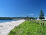
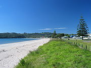
. It is situated on the coast of Mercury Bay
Mercury Bay
Mercury Bay is a large V-shaped bay on the eastern coast of the Coromandel Peninsula on the North Island of New Zealand. This bay was named by the English navigator Captain James Cook during his exploratory expeditions. By the Māori it was named Te-Whanganui-o-Hei, the great bay of Hei.On November...
, the body of water stretching from the Mercury Islands
Mercury Islands
The Mercury Islands lie off the northeast coast of New Zealand's North Island. They are located off the coast of the Coromandel Peninsula, and northeast of the town of Whitianga....
in the north to approximately Tairua
Tairua
The town of Tairua is on the east coast of the Coromandel Peninsula in the North Island of New Zealand. It lies at the mouth of the Tairua River on its north bank and on the small Paku Peninsula. The population was 1,269 in the 2006 Census, a decrease of 192 from 2001...
.
Industry
Historically Whitianga was a centre for boat building, kauri milling, flax milling, gold mining and gum diggingGum-digger
Kauri gum, a fossilized resin detracted from kauri trees, is used for chewing or tattooing, and often is made into jewellery. The gum comes from kauri trees found in Agathis australis forests. The trees once covered much of the New Zealand North Island, before Māori and European settlers caused...
. For many years, it was a leading timber port, with sailing ships from Norway
Norway
Norway , officially the Kingdom of Norway, is a Nordic unitary constitutional monarchy whose territory comprises the western portion of the Scandinavian Peninsula, Jan Mayen, and the Arctic archipelago of Svalbard and Bouvet Island. Norway has a total area of and a population of about 4.9 million...
, Sweden
Sweden
Sweden , officially the Kingdom of Sweden , is a Nordic country on the Scandinavian Peninsula in Northern Europe. Sweden borders with Norway and Finland and is connected to Denmark by a bridge-tunnel across the Öresund....
, France
France
The French Republic , The French Republic , The French Republic , (commonly known as France , is a unitary semi-presidential republic in Western Europe with several overseas territories and islands located on other continents and in the Indian, Pacific, and Atlantic oceans. Metropolitan France...
, Italy
Italy
Italy , officially the Italian Republic languages]] under the European Charter for Regional or Minority Languages. In each of these, Italy's official name is as follows:;;;;;;;;), is a unitary parliamentary republic in South-Central Europe. To the north it borders France, Switzerland, Austria and...
and Great Britain
Great Britain
Great Britain or Britain is an island situated to the northwest of Continental Europe. It is the ninth largest island in the world, and the largest European island, as well as the largest of the British Isles...
coming to load timber. Overseas vessels of 2000 tons with a draught of 18" and carrying with their decks loads over a million feet of timber worked the harbour entrance. The larger ships were towed into the port from near Centre Island. Over a period of sixty years, it is estimated over 500 million feet of kauri was exported from the Whitianga district.
The first kauri gum was exported in 1844. It reached its peak in 1899 when over 11,000 long ton
Long ton
Long ton is the name for the unit called the "ton" in the avoirdupois or Imperial system of measurements, as used in the United Kingdom and several other Commonwealth countries. It has been mostly replaced by the tonne, and in the United States by the short ton...
s of gum was exported at an average of $120 per ton.
Today Whitianga serves as a small regional centre for the eastern side of the Coromandel Peninsula
Coromandel Peninsula
The Coromandel Peninsula lies in the North Island of New Zealand. It is part of the Waikato Region and Thames-Coromandel District and extends 85 kilometres north from the western end of the Bay of Plenty, forming a natural barrier to protect the Hauraki Gulf and the Firth of Thames in the west...
/ Mercury Bay
Mercury Bay
Mercury Bay is a large V-shaped bay on the eastern coast of the Coromandel Peninsula on the North Island of New Zealand. This bay was named by the English navigator Captain James Cook during his exploratory expeditions. By the Māori it was named Te-Whanganui-o-Hei, the great bay of Hei.On November...
area and is a focal point for local fishing, farming and tourism industry, such as to the nearby Te Whanganui-A-Hei (Cathedral Cove)
Te Whanganui-A-Hei (Cathedral Cove)
Te Whanganui-A-Hei Marine Reserve is a marine reserve on the Coromandel Peninsula in New Zealand.Cathedral Cove is named after the cave located there linking Mare’s Leg Cove to Cathedral Cove. Gemstone Bay and Stingray Bay are also located within the reserve...
marine reserve and associated famous beach / cave. Cathedral Cove was used in the movie The Chronicles of Narnia: Prince Caspian
The Chronicles of Narnia: Prince Caspian
The Chronicles of Narnia: Prince Caspian is a 2008 epic fantasy film based on Prince Caspian, the second published, fourth chronological novel in C. S. Lewis's epic fantasy series, The Chronicles of Narnia. It is the second in The Chronicles of Narnia film series from Walden Media, following The...
.
Education
Mercury Bay Area School is a coeducational composite (years 1-15) school with a decile ratingSocio-Economic Decile
Decile, Socio-Economic Decile or Socio-Economic Decile Band is a widely used measure in education in New Zealand used to target funding and support to more needy schools....
of 6 and a roll of 759. The first primary school opened in the area in 1872. A District High School opened in 1951 and moved to the present site two years later. In February 1981 it became an area school. It is now New Zealand's largest Area School.
Controversies
In 2010 Mercury Bay Area School made national news when it allegedly covered up an alleged sexual assault on a comatose female student, allegedly destroying films of the event instead of reporting the matter to police or to the girl's parents. Subsequently, the police found no criminality in alleged sex tape incident. The school is currently under Statutory Management after a series of complaints from parents and community.In 2011 Mercury Bay Area School again made national news when it was revealed that teacher Pat Doube placed adhesive tape over the mouths of two 7 year olds as a punishment for talking. The teacher was not stood down until she resigned in October 2011 due to pressure from school staff.
Events
An Annual Scallop Festival is held in August to celebrate seafood, particularly scallopScallop
A scallop is a marine bivalve mollusk of the family Pectinidae. Scallops are a cosmopolitan family, found in all of the world's oceans. Many scallops are highly prized as a food source...
s.
The Whitianga Speed Festival
Whitianga Festival of Speed
The Whitianga Festival of Speed is a popular Motorsport festival held in the seaside town of Whitianga on the Coromandel Peninsula in New Zealand...
was first held in 2009.
A New Year's Eve festival and concert, known as Coromandel Gold, was first held in 2009.