

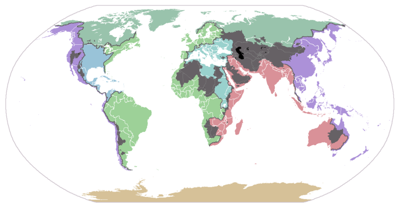
List of endorheic basins
Encyclopedia
Africa
- Chott MelrhirChott MelrhirChott Melrhir also known as Chott Melghir or Chott Melhir is an endorheic salt lake in northeastern Algeria. It the westernmost part of a series of depressions, which extend from the Gulf of Gabès into the Sahara. They were created between Miocene and Early Pleistocene as a result of compression...
(Algeria) - Chott Ech CherguiChott Ech CherguiChott Ech Chergui is a large endorheic salt lake in northwestern Algeria, located at in the Saharan Atlas.Lake has an area of about 2000 km² and is one of the largest lakes in Algeria; Ramsar site has an area of 8555 km²....
(Algeria) - Chott el Hodna (Algeria)
- Tidikelt Depression (Algeria)
- Sebkha Azzel Matti
- Sebhka Mekerrhane
- Tunisian salt lakesTunisian salt lakesThe Tunisian salt lakes are a series of lakes in central Tunisia, lying south of the Atlas Mountains at the northern edge of the Sahara. The lakes include, from east to west, the Chott el Fedjedji, Chott el Djerid, and Chott el Gharsa....
(Tunisia)- Chott el DjeridChott el DjeridChott el Djerid , also spelt Shaţţ al Jarīd, Sciott Gerid, and Shott el Jerid, is a large endorheic salt lake in southern Tunisia.-Geography:The bottom of Chott el Djerid is located between 10 and 25 meters above sea level....
- Chott el Gharsa
- Chott el Djerid
- Qattara DepressionQattara DepressionThe Qattara Depression is a depression in the north west of Egypt in the Matruh Governorate and is part of the Libyan Desert. It lies below sea level and is covered with salt pans, sand dunes and salt marshes. The region extends between latitudes of 28°35' and 30°25' North and longitudes of 26°20'...
(Egypt) - Siwa Depression (Egypt)
- Lake Chad Basin (CameroonCameroonCameroon, officially the Republic of Cameroon , is a country in west Central Africa. It is bordered by Nigeria to the west; Chad to the northeast; the Central African Republic to the east; and Equatorial Guinea, Gabon, and the Republic of the Congo to the south. Cameroon's coastline lies on the...
, Chad, Niger, NigeriaNigeriaNigeria , officially the Federal Republic of Nigeria, is a federal constitutional republic comprising 36 states and its Federal Capital Territory, Abuja. The country is located in West Africa and shares land borders with the Republic of Benin in the west, Chad and Cameroon in the east, and Niger in...
) - Western Equatorial Crater Lakes (Cameroon)
- Lake Barombi MboLake Barombi MboLake Barombi Mbo or Barombi-Ma-Mbu is a lake in the Southwest Region of Cameroon. It is located in the Cameroon volcanic chain, and is the largest volcanic lake in this region. It is one of the oldest radiocarbon-dated lakes in Africa...
- Lake BerminLake BerminLake Bermin is a small lake in the volcanic chain in the Southwest Region of Cameroon. It is a volcanic lake with a crater rim that rises to a height of about...
- Lake Dissoni/Soden
- Lake Benakouma
- Lake Kotto
- Lake Mboandong
- Lake Barombi Mbo
- Makgadikgadi Pans (BotswanaBotswanaBotswana, officially the Republic of Botswana , is a landlocked country located in Southern Africa. The citizens are referred to as "Batswana" . Formerly the British protectorate of Bechuanaland, Botswana adopted its new name after becoming independent within the Commonwealth on 30 September 1966...
) - Northern Eastern Rift (DjiboutiDjiboutiDjibouti , officially the Republic of Djibouti , is a country in the Horn of Africa. It is bordered by Eritrea in the north, Ethiopia in the west and south, and Somalia in the southeast. The remainder of the border is formed by the Red Sea and the Gulf of Aden at the east...
, EritreaEritreaEritrea , officially the State of Eritrea, is a country in the Horn of Africa. Eritrea derives it's name from the Greek word Erethria, meaning 'red land'. The capital is Asmara. It is bordered by Sudan in the west, Ethiopia in the south, and Djibouti in the southeast...
, EthiopiaEthiopiaEthiopia , officially known as the Federal Democratic Republic of Ethiopia, is a country located in the Horn of Africa. It is the second-most populous nation in Africa, with over 82 million inhabitants, and the tenth-largest by area, occupying 1,100,000 km2...
)- Afar DepressionAfar DepressionThe Afar Triangle is a geological depression that is caused by the Afar Triple Junction which is part of the Great Rift Valley. It overlaps Eritrea, Djibouti and the entire Afar Region of Ethiopia. The Afar Triangle includes the Danakil Depression and the lowest point in Africa, Lake Asal...
(Djibouti, Eritrea, Ethiopia) - Ethiopian Rift Valley lakes (Ethiopia)
- Afar Depression
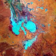
- Lake TurkanaLake TurkanaLake Turkana , formerly known as Lake Rudolf, is a lake in the Great Rift Valley in Kenya, with its far northern end crossing into Ethiopia. It is the world's largest permanent desert lake and the world's largest alkaline lake...
Basin (EthiopiaEthiopiaEthiopia , officially known as the Federal Democratic Republic of Ethiopia, is a country located in the Horn of Africa. It is the second-most populous nation in Africa, with over 82 million inhabitants, and the tenth-largest by area, occupying 1,100,000 km2...
, KenyaKenyaKenya , officially known as the Republic of Kenya, is a country in East Africa that lies on the equator, with the Indian Ocean to its south-east...
) - Southern Eastern Rift (Kenya, Tanzania)
- Lake LogipiLake LogipiLake Logipi is a saline, alkaline lake that lies at the northern end of the arid Suguta Valley in the northern Kenya Rift. It is separated from Lake Turkana by the Barrier volcanic complex, a group of young volcanoes that last erupted during the late 19th Century or early 20th Century...
(Kenya) - Lake BaringoLake BaringoLake Baringo is, after Lake Turkana, the most northern of the Great Rift Valley lakes of Kenya, with a surface area of about and an elevation of about . The lake is fed by several rivers, El Molo, Perkerra and Ol Arabel, and has no obvious outlet; the waters are assumed to seep through lake...
(Kenya) - Lake BogoriaLake BogoriaLake Bogoria is a saline, alkaline lake that lies in a volcanic region in a half-graben basin south of Lake Baringo, Kenya, a little north of the equator. Lake Bogoria, like Lake Nakuru, Lake Elmenteita, and Lake Magadi further south in the Rift Valley, and Lake Logipi to the north, is home at...
(Kenya) - Lake NakuruLake NakuruLake Nakuru is one of the Rift Valley soda lakes at an elevation of 1754 m above sea level. It lies to the south of Nakuru, in the rift valley of Kenya and is protected by Lake Nakuru National Park....
(Kenya) - Lake ElmenteitaLake ElmenteitaLake Elmenteita, also spelled Elementaita, is a soda lake, in the eastern limb of East Africa's Great Rift Valley, about 120 km northwest of Nairobi, Kenya.- Geography :...
(Kenya) - Lake NaivashaLake NaivashaLake Naivasha is a freshwater lake in Kenya, lying north west of Nairobi, outside the town of Naivasha. It is part of the Great Rift Valley. The name derives from the local Maasai name Nai'posha, meaning "rough water" because of the sudden storms which can arise...
(Kenya) - Lake MagadiLake MagadiLake Magadi is the southernmost lake in the Kenya Rift Valley, lying in a catchment of faulted volcanic rocks, north of Tanzania's Lake Natron. During the dry season, it is 80% covered by soda and is well known for its wading birds, including flamingos....
(Kenya) - Lake NatronLake NatronLake Natron is a salt lake located in northern Tanzania, close to the Kenyan border, in the eastern branch of Africa's Great Rift Valley. The lake is fed by the Ewaso Ng'iro River but also by mineral-rich hot springs and is quite shallow, less than three meters deep, and varies in width depending...
(Tanzania) - Lake EyasiLake EyasiLake Eyasi is a seasonal shallow endorheic salt lake on the floor of the Great Rift Valley at the base of the Serengeti Plateau, just south of the Serengeti National Park and immediately southwest of the Ngorongoro Crater in the Crater Highlands of Tanzania...
(Tanzania)
- Lake Logipi
- Lake RukwaLake RukwaLake Rukwa is a lake in southwestern Tanzania. The alkaline Lake Rukwa lies midway between Lake Tanganyika and Lake Nyasa at an elevation of about 800 metres, in a parallel branch of the rift system. The lake has seen large fluctuations in its size over the years, due to varying inflow of streams...
(Tanzania) - Lake ChilwaLake ChilwaLake Chilwa is the second-largest lake in Malawi after Lake Malawi. It is in eastern Zomba District, near the border with Mozambique. Approximately 60 km long and 40 km wide, the lake is surrounded by extensive wetlands....
(MalawiMalawiThe Republic of Malawi is a landlocked country in southeast Africa that was formerly known as Nyasaland. It is bordered by Zambia to the northwest, Tanzania to the northeast, and Mozambique on the east, south and west. The country is separated from Tanzania and Mozambique by Lake Malawi. Its size...
) - Lake ChiutaLake ChiutaLake Chiuta is a shallow lake on the border between Malawi and Mozambique. It lies to the north of Lake Chilwa and to the south of Lake Amaramba, which has no outlet, and the lakes are separated by a sandy ridge...
(Malawi, Mozambique) - Etosha Basin (AngolaAngolaAngola, officially the Republic of Angola , is a country in south-central Africa bordered by Namibia on the south, the Democratic Republic of the Congo on the north, and Zambia on the east; its west coast is on the Atlantic Ocean with Luanda as its capital city...
, NamibiaNamibiaNamibia, officially the Republic of Namibia , is a country in southern Africa whose western border is the Atlantic Ocean. It shares land borders with Angola and Zambia to the north, Botswana to the east and South Africa to the south and east. It gained independence from South Africa on 21 March...
) - Okavango BasinOkavango BasinThe Okavango Basin is an endorheic basin in southwestern Africa, which extends across portions of Angola, Botswana, Namibia and Zimbabwe. The basin covers an area of 721,000 square kilometers....
(Angola, BotswanaBotswanaBotswana, officially the Republic of Botswana , is a landlocked country located in Southern Africa. The citizens are referred to as "Batswana" . Formerly the British protectorate of Bechuanaland, Botswana adopted its new name after becoming independent within the Commonwealth on 30 September 1966...
, Namibia, Zimbabwe)
Australia
- Lake Eyre BasinLake Eyre BasinThe Lake Eyre basin is a drainage basin that covers just under one-sixth of all Australia. The Lake Eyre Basin is the largest endorheic basin in Australia and amongst the largest in the world, covering about 1,200,000 square kilometres, including much of inland Queensland, large portions of South...
(QueenslandQueenslandQueensland is a state of Australia, occupying the north-eastern section of the mainland continent. It is bordered by the Northern Territory, South Australia and New South Wales to the west, south-west and south respectively. To the east, Queensland is bordered by the Coral Sea and Pacific Ocean...
, New South WalesNew South WalesNew South Wales is a state of :Australia, located in the east of the country. It is bordered by Queensland, Victoria and South Australia to the north, south and west respectively. To the east, the state is bordered by the Tasman Sea, which forms part of the Pacific Ocean. New South Wales...
, Northern TerritoryNorthern TerritoryThe Northern Territory is a federal territory of Australia, occupying much of the centre of the mainland continent, as well as the central northern regions...
, South AustraliaSouth AustraliaSouth Australia is a state of Australia in the southern central part of the country. It covers some of the most arid parts of the continent; with a total land area of , it is the fourth largest of Australia's six states and two territories.South Australia shares borders with all of the mainland...
), which drains into the highly variable Lake EyreLake EyreLake Eyre is the lowest point in Australia, at approximately below sea level, and, on the rare occasions that it fills, it is the largest lake in Australia and 18th largest in the world...
and includes Lake FromeLake FromeLake Frome is a large endorheic lake in South Australia, east of the Northern Flinders Ranges. It is a large, shallow, unvegetated salt pan, 100 km long and 40 km wide, lying mostly below sea level and having a total surface area of 259,615 hectares...
. - Lake TorrensLake TorrensLake Torrens is a salt lake in central South Australia. It is located in the Lake Torrens National Park....
(South Australia) - Lake CorangamiteLake CorangamiteLake Corangamite is Victoria’s largest natural lake, located near Colac in south-west Victoria, Australia in the Lakes and Craters region of the Victorian Volcanic Plains. The lake is hypersaline, and salinity levels have increased dramatically as the lake level has dropped in recent decades...
(western VictoriaVictoria (Australia)Victoria is the second most populous state in Australia. Geographically the smallest mainland state, Victoria is bordered by New South Wales, South Australia, and Tasmania on Boundary Islet to the north, west and south respectively....
) - Lake George (New South Wales), formerly connected to the Murray-Darling BasinMurray-Darling BasinThe Murray-Darling basin is a large geographical area in the interior of southeastern Australia, whose name is derived from its two major rivers, the Murray River and the Darling River. It drains one-seventh of the Australian land mass, and is currently by far the most significant agricultural...
.
Eurasia
- Caspian SeaCaspian SeaThe Caspian Sea is the largest enclosed body of water on Earth by area, variously classed as the world's largest lake or a full-fledged sea. The sea has a surface area of and a volume of...
Basin (ArmeniaArmeniaArmenia , officially the Republic of Armenia , is a landlocked mountainous country in the Caucasus region of Eurasia...
, AzerbaijanAzerbaijanAzerbaijan , officially the Republic of Azerbaijan is the largest country in the Caucasus region of Eurasia. Located at the crossroads of Western Asia and Eastern Europe, it is bounded by the Caspian Sea to the east, Russia to the north, Georgia to the northwest, Armenia to the west, and Iran to...
, GeorgiaGeorgia (country)Georgia is a sovereign state in the Caucasus region of Eurasia. Located at the crossroads of Western Asia and Eastern Europe, it is bounded to the west by the Black Sea, to the north by Russia, to the southwest by Turkey, to the south by Armenia, and to the southeast by Azerbaijan. The capital of...
) IranIranIran , officially the Islamic Republic of Iran , is a country in Southern and Western Asia. The name "Iran" has been in use natively since the Sassanian era and came into use internationally in 1935, before which the country was known to the Western world as Persia...
, KazakhstanKazakhstanKazakhstan , officially the Republic of Kazakhstan, is a transcontinental country in Central Asia and Eastern Europe. Ranked as the ninth largest country in the world, it is also the world's largest landlocked country; its territory of is greater than Western Europe...
, RussiaRussiaRussia or , officially known as both Russia and the Russian Federation , is a country in northern Eurasia. It is a federal semi-presidential republic, comprising 83 federal subjects...
, TurkeyTurkeyTurkey , known officially as the Republic of Turkey , is a Eurasian country located in Western Asia and in East Thrace in Southeastern Europe...
, TurkmenistanTurkmenistanTurkmenistan , formerly also known as Turkmenia is one of the Turkic states in Central Asia. Until 1991, it was a constituent republic of the Soviet Union, the Turkmen Soviet Socialist Republic . Turkmenistan is one of the six independent Turkic states...
) including the Volga RiverVolga RiverThe Volga is the largest river in Europe in terms of length, discharge, and watershed. It flows through central Russia, and is widely viewed as the national river of Russia. Out of the twenty largest cities of Russia, eleven, including the capital Moscow, are situated in the Volga's drainage...
. - Aral SeaAral SeaThe Aral Sea was a lake that lay between Kazakhstan in the north and Karakalpakstan, an autonomous region of Uzbekistan, in the south...
Basin (AfghanistanAfghanistanAfghanistan , officially the Islamic Republic of Afghanistan, is a landlocked country located in the centre of Asia, forming South Asia, Central Asia and the Middle East. With a population of about 29 million, it has an area of , making it the 42nd most populous and 41st largest nation in the world...
, KyrgyzstanKyrgyzstanKyrgyzstan , officially the Kyrgyz Republic is one of the world's six independent Turkic states . Located in Central Asia, landlocked and mountainous, Kyrgyzstan is bordered by Kazakhstan to the north, Uzbekistan to the west, Tajikistan to the southwest and China to the east...
, Kazakhstan, TajikistanTajikistanTajikistan , officially the Republic of Tajikistan , is a mountainous landlocked country in Central Asia. Afghanistan borders it to the south, Uzbekistan to the west, Kyrgyzstan to the north, and China to the east....
, Turkmenistan, UzbekistanUzbekistanUzbekistan , officially the Republic of Uzbekistan is a doubly landlocked country in Central Asia and one of the six independent Turkic states. It shares borders with Kazakhstan to the west and to the north, Kyrgyzstan and Tajikistan to the east, and Afghanistan and Turkmenistan to the south....
) including the Syr DaryaSyr DaryaThe Syr Darya , also transliterated Syrdarya or Sirdaryo, is a river in Central Asia, sometimes known as the Jaxartes or Yaxartes from its Ancient Greek name . The Greek name is derived from Old Persian, Yakhsha Arta , a reference to the color of the river's water...
and Amu DaryaAmu DaryaThe Amu Darya , also called Oxus and Amu River, is a major river in Central Asia. It is formed by the junction of the Vakhsh and Panj rivers...
rivers.
- Lake BalkhashLake BalkhashLake Balkhash is one of the largest lakes in Asia and 12th largest continental lake in the world. It is located in southeastern Kazakhstan, in Central Asia, and belongs to an endorheic basin shared by Kazakhstan and China, with a small part in Kyrgyzstan. The basin drains into the lake via seven...
Basin (China, Kazakhstan) - Emin ValleyEmin ValleyThe Emin Valley is located on the China-Kazakhstan border with an area of about 65,000 square kilometers. It has an ecosystem of mostly grasslands and steppes, with two saline lakes and mountains with temperate climates....
(China, Kazakhstan) - Issyk-Kul, Son-KulSon-KulSong Köl is an alpine lake in northern Naryn Province, Kyrgyzstan. It is the second largest lake in Kyrgyzstan after Issyk Kul Lake. Its name, meaning "following lake", is popularly considered to refer to this relation...
and Chatyr-KulChatyr-KulChatyr-Kul is an endorheic alpine lake in the Tian Shan mountains in At-Bashi District of Naryn Province, Kyrgyzstan; it lies in the lower part of Chatyr-Kul Depression near the Torugart Pass border crossing into China. The name of the lake means “Celestial Lake” in Kyrgyz...
lakes (Kyrgyzstan) - Dzungarian Basin (China)
- Ebinur Lake
- Uvs Nuur basin (Mongolia, Russia)
- Hyargas Lake, Har Us Lake, Har Lake (Mongolia, Russia)
- Tarim BasinTarim BasinThe Tarim Basin is a large endorheic basin occupying an area of about . It is located in the Xinjiang Uyghur Autonomous Region in China's far west. Its northern boundary is the Tian Shan mountain range and its southern is the Kunlun Mountains on the northern edge of the Tibetan Plateau. The...
(China)- Lop NurLop NurLop Lake or Lop Nur is a group of small, now seasonal salt lake sand marshes between the Taklamakan and Kuruktag deserts in the Bayingolin Mongol Autonomous Prefecture, southeastern portion of Xinjiang Uygur Autonomous Region in the People's Republic of China.The lake system into which the Tarim...
- Lop Nur
- Gobi DesertGobi DesertThe Gobi is a large desert region in Asia. It covers parts of northern and northwestern China, and of southern Mongolia. The desert basins of the Gobi are bounded by the Altai Mountains and the grasslands and steppes of Mongolia on the north, by the Hexi Corridor and Tibetan Plateau to the...
(China, Mongolia) - Tibetan PlateauTibetan PlateauThe Tibetan Plateau , also known as the Qinghai–Tibetan Plateau is a vast, elevated plateau in Central Asia covering most of the Tibet Autonomous Region and Qinghai, in addition to smaller portions of western Sichuan, southwestern Gansu, and northern Yunnan in Western China and Ladakh in...
(China)- Nam Lake
- Siling Lake
- Tangra Lake
- Ngangze Lake
- Taro Lake
- Ngangla Ringco
- Zhari NamcoZhari NamcoZhari Namco or Lake Trari Nam(,) is a lake in Tibet, it is bounded on the west by the Ngari Prefecture of Coqên County, and on the east by the Ngamring County of Xigazê Prefecture. Zhari Namco is 996.9 km 2, with a drainage area of 15,433.2 km 2, an elevation of 4,613 m, length 54.3 km and mean...
- Dagze Lake
- Dogai Coring Lake
- Qinghai LakeQinghai LakeQinghai Lake , is a saline lake situated in the province of Qinghai, and is the largest lake in China. The names Qinghai and Kokonor both mean "Blue/Teal Sea/Lake" in Chinese and Mongolian. It is located about west of the provincial capital of Xining at 3,205 m above sea level in a depression...
(China) - Qaidam Basin (China)
- Kumkol Basin (between the Altyn-TaghAltyn-TaghAltyn-Tagh, Astyn-Tagh, Altun Mountains, Altun Shan or Aerjin Shan Tagh proper is a part of the range south of Lop Nor), is a mountain range in northwestern China that separates the eastern Tarim Basin from the Tibetan Plateau...
and the KunlunKunlun MountainsThe Kunlun Mountains are one of the longest mountain chains in Asia, extending more than 3,000 km. In the broadest sense, it forms the northern edge of the Tibetan Plateau south of the Tarim Basin and the Gansu Corridor and continues east south of the Wei River to end at the North China Plain.The...
)
- Turpan Depression (Chna)
- Sistan BasinSistan BasinThe Sistan Basin is an inland endorheic basin encompassing large parts of southwestern Afghanistan and southeastern Iran, one of the driest regions in the world and an area subjected to prolonged droughts...
(Afghanistan, Iran, PakistanPakistanPakistan , officially the Islamic Republic of Pakistan is a sovereign state in South Asia. It has a coastline along the Arabian Sea and the Gulf of Oman in the south and is bordered by Afghanistan and Iran in the west, India in the east and China in the far northeast. In the north, Tajikistan...
) - Hamun-e Mashkid (Iran, Pakistan)
- Hari River, Afghanistan (Tedzhen River) (Afghanistan, Iran, Turkmenistan)
- Murgab RiverMurgab RiverMurghāb , or Morghāb, also transliterated from Tajiki Мурғоб and Russian Мургаб as Murghob and Murgab, is the name of two distinct rivers in Central Asia:...
(Afghanistan, Turkmenistan) - Iranian PlateauIranian plateauThe Iranian plateau, or Iranic plateau, is a geological formation in Southwest Asia. It is the part of the Eurasian Plate wedged between the Arabian and Indian plates, situated between the Zagros mountains to the west, the Caspian Sea and the Kopet Dag to the north, the Hormuz Strait and Persian...
(Iran)- Bejestan
- Dasht-e KavirDasht-e KavirDasht-e Kavir , also known as Kavir-e Namak or Great Salt Desert is a large desert lying in the middle of the Iranian plateau. It is about 800 kilometers long and 320 kilometers wide with a total surface area of about 77,600 square kilometers , making it the Earth's 23rd largest desert...
- Dasht-e LutDasht-e LutDasht-e Lut, also spelled Dasht-i-Lut, is a large salt desert in southeastern Iran and is the world's 25th largest desert.Iran is climatically part of the Afro-Asian belt of deserts that stretch from the Cape Verde islands off West Africa all the way to Mongolia near Beijing, China...
- Zayande River
- Hamun-e Jaz MurianHamun-e Jaz MurianHamun-e Jaz Murian is an inland basin or depression in southeast Iran, straddling the provinces of Kerman and Sistan and Baluchistan. At the center of the basin is a "seasonal lake," or hamun. The lake can remain almost totally dry during dry years, while in wetter years it can have water year...
- Kor River (Kor Rud)
- Lake Maharlu 29.481°N 52.805°W
- Namak LakeNamak LakeNamak Lake is a salt lake in Iran. It is located approximately east of the City of Qom at an elevation of above sea level. The lake has a surface area of about 1800 km², but most of this is dry. Water only covers 1 km². The lake only reaches a depth between 45 centimetres to 1 metre...
- SirjanSirjanSirjan is a city in and the capital of Sirjan County, Kerman Province, Iran. At the 2006 census, its population was 167,014, in 40,605 families....
- YazdYazdYazd is the capital of Yazd Province in Iran, and a centre of Zoroastrian culture. The city is located some 175 miles southeast of Isfahan. At the 2006 census, the population was 423,006, in 114,716 families....
- Lake UrmiaLake UrmiaLake Urmia , ancient name: Lake Matiene) is a salt lake in northwestern Iran, near Iran's border with Turkey. The lake is between the Iranian provinces of East Azerbaijan and West Azerbaijan, west of the southern portion of the similarly shaped Caspian Sea...
(Iran) - Lake VanLake VanLake Van is the largest lake in Turkey, located in the far east of the country in Van district. It is a saline and soda lake, receiving water from numerous small streams that descend from the surrounding mountains. Lake Van is one of the world's largest endorheic lakes . The original outlet from...
(Turkey) - Central Anatolian lakes (Turkey)
- Lake TuzLake TuzLake Tuz is the second largest lake in Turkey with its surface area and one of the largest hypersaline lakes in the world. It is located in the Central Anatolia Region, northeast of Konya, south-southeast of Ankara and northwest of Aksaray.-Geography:...
- Lake BeyşehirLake BeysehirLake Beyşehir is a large freshwater lake in Isparta and Konya provinces, southwestern part of Turkey. It is located at around . It has an area of 650.00 km² and is 45 km long and 20 km wide. It carries the same name as the principal urban center of its region, Beyşehir.Water level...
- Lake EğirdirLake EgirdirEğirdir is the name of a lake and of the town situated on the shore of that lake in Turkey. The lake lies in the Turkish Lakes Region and is 186 kilometers north of Antalya...
- Lake BurdurLake BurdurLake Burdur is a large saline lake of tectonic origin, positioned at the frontier between Burdur and Isparta provinces, in southwestern Turkey. It is located at around . It has an area of 250.00 km² and maximum depth variously reported at between 50 and 110 m. Water level in the lake fluctuates...
- Lake AcıgölLake AcigölAcıgöl is a lake in Turkey's inner Aegean Region, in a closed basin at the junction between Denizli Province, Afyonkarahisar Province and Burdur Province. Its surface area varies greatly through the seasons, with 100 km² in spring and 35 km² in late summer, with a maximum depth of 1.63 m...
- Lake Tuz
- Syrian DesertSyrian DesertThe Syrian Desert , also known as the Syro-Arabian desert is a combination of steppe and true desert that is located in the northern Arabian Peninsula covering 200,000 square miles . also the desert is very rocky and flat...
Basins (SyriaSyriaSyria , officially the Syrian Arab Republic , is a country in Western Asia, bordering Lebanon and the Mediterranean Sea to the West, Turkey to the north, Iraq to the east, Jordan to the south, and Israel to the southwest....
, JordanJordanJordan , officially the Hashemite Kingdom of Jordan , Al-Mamlaka al-Urduniyya al-Hashemiyya) is a kingdom on the East Bank of the River Jordan. The country borders Saudi Arabia to the east and south-east, Iraq to the north-east, Syria to the north and the West Bank and Israel to the west, sharing...
)- Sabkhat al Muh (Syria)
- Buhayrat al 'Utaybah (Syria)
- Arabian Plateau (Saudi ArabiaSaudi ArabiaThe Kingdom of Saudi Arabia , commonly known in British English as Saudi Arabia and in Arabic as as-Sa‘ūdiyyah , is the largest state in Western Asia by land area, constituting the bulk of the Arabian Peninsula, and the second-largest in the Arab World...
)- Wadi Rima
- Wadi Dawasir
- Dead SeaDead SeaThe Dead Sea , also called the Salt Sea, is a salt lake bordering Jordan to the east and Israel and the West Bank to the west. Its surface and shores are below sea level, the lowest elevation on the Earth's surface. The Dead Sea is deep, the deepest hypersaline lake in the world...
Basin (IsraelIsraelThe State of Israel is a parliamentary republic located in the Middle East, along the eastern shore of the Mediterranean Sea...
, Jordan, LebanonLebanonLebanon , officially the Republic of LebanonRepublic of Lebanon is the most common term used by Lebanese government agencies. The term Lebanese Republic, a literal translation of the official Arabic and French names that is not used in today's world. Arabic is the most common language spoken among...
, Palestinian TerritoriesPalestinian territoriesThe Palestinian territories comprise the West Bank and the Gaza Strip. Since the Palestinian Declaration of Independence in 1988, the region is today recognized by three-quarters of the world's countries as the State of Palestine or simply Palestine, although this status is not recognized by the...
, Syria) - (IndiaIndiaIndia , officially the Republic of India , is a country in South Asia. It is the seventh-largest country by geographical area, the second-most populous country with over 1.2 billion people, and the most populous democracy in the world...
)- Sambhar Lake (IndiaIndiaIndia , officially the Republic of India , is a country in South Asia. It is the seventh-largest country by geographical area, the second-most populous country with over 1.2 billion people, and the most populous democracy in the world...
) - Tso Kar (IndiaIndiaIndia , officially the Republic of India , is a country in South Asia. It is the seventh-largest country by geographical area, the second-most populous country with over 1.2 billion people, and the most populous democracy in the world...
) - Tso Moriri (IndiaIndiaIndia , officially the Republic of India , is a country in South Asia. It is the seventh-largest country by geographical area, the second-most populous country with over 1.2 billion people, and the most populous democracy in the world...
) - Pangong TsoPangong TsoPangong Tso is an endorheic lake in the Himalayas situated at a height of about . It is long and extends from India to Tibet. 60% of the length of the lake lies in China. The lake is wide at its broadest point...
(IndiaIndiaIndia , officially the Republic of India , is a country in South Asia. It is the seventh-largest country by geographical area, the second-most populous country with over 1.2 billion people, and the most populous democracy in the world...
)
- Sambhar Lake (India
- Neusiedlersee (AustriaAustriaAustria , officially the Republic of Austria , is a landlocked country of roughly 8.4 million people in Central Europe. It is bordered by the Czech Republic and Germany to the north, Slovakia and Hungary to the east, Slovenia and Italy to the south, and Switzerland and Liechtenstein to the...
) - Lake TrasimenoLake TrasimenoLake Trasimeno , also referred to as Trasimene or Thrasimene in English, is the largest lake on the Italian peninsula south of the Po River with a surface area of 128 km2, slightly less than Lake Como...
(ItalyItalyItaly , officially the Italian Republic languages]] under the European Charter for Regional or Minority Languages. In each of these, Italy's official name is as follows:;;;;;;;;), is a unitary parliamentary republic in South-Central Europe. To the north it borders France, Switzerland, Austria and...
) - Laguna de GallocantaLaguna de GallocantaThe Gallocanta Lake is an endorheic lake located just to the south of Gallocanta village, between the Aragonese comarcas of Campo de Daroca and Comarca del Jiloca, Aragon, Spain...
(SpainSpainSpain , officially the Kingdom of Spain languages]] under the European Charter for Regional or Minority Languages. In each of these, Spain's official name is as follows:;;;;;;), is a country and member state of the European Union located in southwestern Europe on the Iberian Peninsula...
)
North America
- Endorheic basins in the Great PlainsGreat PlainsThe Great Plains are a broad expanse of flat land, much of it covered in prairie, steppe and grassland, which lies west of the Mississippi River and east of the Rocky Mountains in the United States and Canada. This area covers parts of the U.S...
- Quill LakesQuill LakesThe Quill Lakes is a wetland complex in Saskatchewan, Canada that encompasses the endorheic basin of three distinct lake wetlands: Big Quill Lake, Middle Quill Lake and Little Quill Lake. On May 27, 1987, it was designated a wetland of international importance via the Ramsar Convention...
, Lenore Lake, and Basin Lake (SaskatchewanSaskatchewanSaskatchewan is a prairie province in Canada, which has an area of . Saskatchewan is bordered on the west by Alberta, on the north by the Northwest Territories, on the east by Manitoba, and on the south by the U.S. states of Montana and North Dakota....
) - Coteau du MissouriCoteau du MissouriThe Coteau du Missouri, or Missouri Plateau, is a large plateau that stretches along the eastern side of the valley of the Missouri River in central North Dakota and north-central South Dakota in the United States...
-Old Wives LakeOld Wives LakeOld Wives Lake is a shallow saline lake in south central Saskatchewan, Canada, about 30 km southwest of Moose Jaw. The lake is fed by the Wood River but seasonal water relatively flattened the terrain, and as such results in significant mudflats. A Migratory Bird Sanctuary was established at the...
(Saskatchewan) - Great Sand Hills-Crane Lake and Bigstick Lake (Saskatchewan)
- Pakowki LakePakowki LakePakowki Lake is an endorheic lake in Alberta, Canada located south of Etzikom, Alberta and not far north is the former town site of Pakowki which may have received it's name from the lake....
(AlbertaAlbertaAlberta is a province of Canada. It had an estimated population of 3.7 million in 2010 making it the most populous of Canada's three prairie provinces...
) - ManitoManitou Lake (Saskatchewan)Manitou Lake is the largest salt-water lake in the prairie provinces, situated in Western Saskatchewan, near Marsden, Saskatchewan. Because the lake is endorheic and quite salty, there are no fish in the lake. There is one large island in the centre which divides it into four bays...
, Tramping, Buffalo, and Sullivan lakes (Alberta, Saskatchewan) - Little Manitou LakeLittle Manitou Lake (Saskatchewan)Little Manitou Lake is a small saltwater lake about 100 kilometres South-East of Saskatoon. The lake was formed by receding glaciers during the most recent ice age. It is fed by underground springs, and has a mineral content high in sodium, magnesium and potassium salts due to it being a terminal...
(Saskatchewan) - Devils Lake (North Dakota)
- Coteau des PrairiesCoteau des PrairiesThe Coteau des Prairies is a plateau approximately 200 miles in length and 100 miles in width , rising from the prairie flatlands in eastern South Dakota, southwestern Minnesota, and northwestern Iowa in the United States...
(mostly South Dakota) - The Sandhills (Nebraska)
- White Woman Basin (Kansas)
- Quill Lakes
- Devil's Lake (Wisconsin)Devil's Lake (Wisconsin)Devil's Lake is an endorheic lake in the South Range of the Baraboo Hills, about two miles south of Baraboo, Wisconsin, in Sauk County, Wisconsin, USA. The lake is one of the primary attractions of the eponymous Devil's Lake State Park....
- Great Divide BasinGreat Divide BasinThe Great Divide Basin is a drainage basin of the Continental Divide of the Americas. The basin is between the Green River watershed on the west and the Medicine Bow River watershed on the east . From the northwest, the basin begins in the "Wind River Range .....
(WyomingWyomingWyoming is a state in the mountain region of the Western United States. The western two thirds of the state is covered mostly with the mountain ranges and rangelands in the foothills of the Eastern Rocky Mountains, while the eastern third of the state is high elevation prairie known as the High...
) - Crater LakeCrater LakeCrater Lake is a caldera lake located in the south-central region of the U.S. state of Oregon. It is the main feature of Crater Lake National Park and famous for its deep blue color and water clarity. The lake partly fills a nearly deep caldera that was formed around 7,700 years agoby the...
(OregonOregonOregon is a state in the Pacific Northwest region of the United States. It is located on the Pacific coast, with Washington to the north, California to the south, Nevada on the southeast and Idaho to the east. The Columbia and Snake rivers delineate much of Oregon's northern and eastern...
) - Great BasinGreat BasinThe Great Basin is the largest area of contiguous endorheic watersheds in North America and is noted for its arid conditions and Basin and Range topography that varies from the North American low point at Badwater Basin to the highest point of the contiguous United States, less than away at the...
in CaliforniaCaliforniaCalifornia is a state located on the West Coast of the United States. It is by far the most populous U.S. state, and the third-largest by land area...
, IdahoIdahoIdaho is a state in the Rocky Mountain area of the United States. The state's largest city and capital is Boise. Residents are called "Idahoans". Idaho was admitted to the Union on July 3, 1890, as the 43rd state....
, NevadaNevadaNevada is a state in the western, mountain west, and southwestern regions of the United States. With an area of and a population of about 2.7 million, it is the 7th-largest and 35th-most populous state. Over two-thirds of Nevada's people live in the Las Vegas metropolitan area, which contains its...
, Oregon, UtahUtahUtah is a state in the Western United States. It was the 45th state to join the Union, on January 4, 1896. Approximately 80% of Utah's 2,763,885 people live along the Wasatch Front, centering on Salt Lake City. This leaves vast expanses of the state nearly uninhabited, making the population the...
and WyomingWyomingWyoming is a state in the mountain region of the Western United States. The western two thirds of the state is covered mostly with the mountain ranges and rangelands in the foothills of the Eastern Rocky Mountains, while the eastern third of the state is high elevation prairie known as the High...
)- Oregon Lakes (California, Oregon)
- Harney BasinHarney BasinThe Harney Basin is a structural basin in southeastern Oregon in the United States at the northwestern corner of the Great Basin. One of the least populated areas of the contiguous United States, it is located largely in northern Harney County, bounded on the north and east by the Columbia Plateau,...
(HarneyHarney LakeHarney Lake is a shallow alkali lake basin located in southeast Oregon, United States, approximately thirty miles south of the town of Burns. The lake lies within the boundary of the Malheur National Wildlife Refuge and is the lowest point in the Blitzen Valley drainage.- History :The lake has been...
and MalheurMalheur LakeMalheur Lake is a lake in an arid region of eastern Oregon, United States near Burns, Oregon. The lake is fed by Donner und Blitzen River from the south and the Silvies River from the north. Malheur Lake has no outlet, though water escapes through ground seepage and by evaporation; widespread...
lakes) (Oregon) - Alvord Lake (Oregon)Alvord Lake (Oregon)Alvord Lake is a seasonal shallow alkali lake in Harney County of the U.S. state of Oregon. Its elevation is . It is located about southeast of Alvord Desert in the Alvord Basin and serves as terminus for all its streams. Its water level varies from dry to several feet deep...
- Goose LakeGoose Lake (Oregon-California)Goose Lake is a large alkaline glacial lake located in the Goose Lake Valley on the Oregon-California border. The north end of the lake is in Lake County, Oregon and the south end is in Modoc County, California. The mountains at the north end of the lake are part of the Fremont National Forest...
(California, Oregon) - SummerSummer Lake (Oregon)Summer Lake is a large, shallow, alkali lake in Lake County, Oregon, United States. It is approximately long and wide, and is located five miles south of the small, unincorporated community of Summer Lake, Oregon. The lake was named by explorer John C. Fremont on his expedition into Central...
and SilverSilver Lake (Oregon)Silver Lake is a lake in Lake County, Oregon, United States. It is east of the community of Silver Lake. It is unknown who first gave the lake its descriptive name. Central Oregon residents attribute it to John C. Frémont, although no proof has been found, and he would not have seen the lake on...
lakes (Oregon)
- Harney Basin
- North Lahontan BasinLahontan ValleyThe Lahontan Valley is in Churchill County in the U.S. state of Nevada. The valley is a landform of the central portion of the prehistoric Lake Lahontan's lakebed of 20,000-9,000 years ago. The valley and the adjacent Carson Sink represent a small portion of the lake bed, and Humboldt Lake is to...
(California, Nevada, Oregon), a system of endorheic sub-basins connected with pluvialPluvial lakeA pluvial lake is a landlocked basin which fills with rainwater during times of glaciation, when precipitation is higher. Pluvial lakes that have since evaporated and dried out may also be referred to as paleolakes.-Geology:...
Lake LahontanLake LahontanLake Lahontan was a large endorheic Pleistocene lake of modern northwestern Nevada that extended into northeastern California and southern Oregon...
- Pyramid LakePyramid LakePyramid Lake is the geographic sink of the Truckee River Basin and is located northeast of Reno. The inflow is moderately high silt-loaded surface runoff....
(a remnant of Lake Lahontan) fed by Truckee RiverTruckee RiverThe Truckee River is a stream in the U.S. states of California and Nevada. The river is about long. Its endorheic drainage basin is about , of which about are in Nevada. The Truckee is the sole outlet of Lake Tahoe and drains part of the high Sierra Nevada, emptying into Pyramid Lake in the Great...
-Lake TahoeLake TahoeLake Tahoe is a large freshwater lake in the Sierra Nevada of the United States. At a surface elevation of , it is located along the border between California and Nevada, west of Carson City. Lake Tahoe is the largest alpine lake in North America. Its depth is , making it the USA's second-deepest...
(California, Nevada)- Honey LakeHoney LakeHoney Lake is an endorheic sink within the Honey Lake Valley located in northeastern California, near the Nevada border. Summer evaporation reduces the lake to a lower level of 12 km² and creates an alkali flat....
-Eagle LakeEagle Lake (Lassen County)Eagle Lake is a lake in Lassen County approximately 15 miles north of Susanville, California. It is the second largest natural lake entirely in the state of California, United States....
(California)
- Honey Lake
- Walker LakeWalker LakeWalker Lake may refer to:*Walker Lake *Walker Lake *Walker Lake *Lake Walker *Walker Lake *Walker Lake...
(another remnant of Lake Lahontan) fed by Walker River (California, Nevada) - Black Rock DesertBlack Rock DesertThe Black Rock Desert is an arid region in the northern Nevada section of the Great Basin with a lakebed that is a dry remnant of Pleistocene Lake Lahontan...
(Nevada) - Carson SinkCarson SinkCarson Sink is a playa in the northeastern portion of the Carson Desert that was formerly the terminus of the Carson River. The sink is currently fed by drainage canals of the Truckee-Carson Irrigation District...
-Carson RiverCarson RiverThe Carson River is a northwestern Nevada river that empties into the Carson Sink, an endorheic basin. The main stem of the river is long....
(Nevada) - Humboldt SinkHumboldt SinkHumboldt Sink is an intermittent dry lake bed, approximately 11 mi long, and 4 mi across, in northwestern Nevada in the United States...
-Humboldt RiverHumboldt RiverThe Humboldt River runs through northern Nevada in the western United States. At approximately long it is the second longest river in the Great Basin, after the Bear River. It has no outlet to the ocean, but instead empties into the Humboldt Sink...
(Nevada) - Quinn RiverQuinn RiverThe Quinn River, once known as the Queen River, is an intermittent river, approximately long, in the desert of northwestern Nevada in the United States. It drains an enclosed basin inside the larger Great Basin....
(Nevada)
- Pyramid Lake
- Bonneville Basin (Idaho, Nevada, Utah, Wyoming), a system of endorheic basins connected to pluvialPluvial lakeA pluvial lake is a landlocked basin which fills with rainwater during times of glaciation, when precipitation is higher. Pluvial lakes that have since evaporated and dried out may also be referred to as paleolakes.-Geology:...
Lake BonnevilleLake BonnevilleLake Bonneville was a prehistoric pluvial lake that covered much of North America's Great Basin region. Most of the territory it covered was in present-day Utah, though parts of the lake extended into present-day Idaho and Nevada. Formed about 32,000 years ago, it existed until about 14,500 years...
- Great Salt LakeGreat Salt LakeThe Great Salt Lake, located in the northern part of the U.S. state of Utah, is the largest salt water lake in the western hemisphere, the fourth-largest terminal lake in the world. In an average year the lake covers an area of around , but the lake's size fluctuates substantially due to its...
(remnant of Lake Bonneville) in Utah - Sevier LakeSevier LakeSevier Lake is an intermittent and endorheic lake which lies in the lowest part of the Sevier Desert, Millard County, Utah. Like Great Salt Lake and Utah Lake, it is a remnant of Pleistocene Lake Bonneville. Sevier Lake is fed primarily by the Beaver and Sevier rivers, and the additional inflow...
(Utah) - Utah LakeUtah LakeUtah Lake is a freshwater lake in the U.S. state of Utah. On the western side of Utah Valley, the lake is overlooked by Mount Timpanogos and Mount Nebo. The lake's only river outlet, the Jordan River, is a tributary of the Great Salt Lake and is highly regulated with pumps. Evaporation accounts...
- Jordan RiverJordan River (Utah)The Jordan River in the U.S. state of Utah is a river about long. Regulated by pumps at its headwaters at Utah Lake, it flows northward through the Salt Lake Valley and empties into the Great Salt Lake. Four of Utah's five largest cities—Salt Lake City, West Valley City, West Jordan and...
- Great Salt Lake
- South Lahontan Basin (California, Nevada), draining into pluvial Lake ManlyLake ManlyLake Manly is a pluvial, former freshwater, endorheic, rift lake that filled the Death Valley basin of Inyo County, California through the Holocene before the area's climate changed to desert. Following its isolation from the Colorado River system, Lake Manly receded by evaporation with Badwater...
in Death ValleyDeath ValleyDeath Valley is a desert valley located in Eastern California. Situated within the Mojave Desert, it features the lowest, driest, and hottest locations in North America. Badwater, a basin located in Death Valley, is the specific location of the lowest elevation in North America at 282 feet below...
- Amargosa RiverAmargosa RiverThe Amargosa River is an intermittent waterway, long, in southern Nevada and eastern California in the United States. It drains a high desert region, the Amargosa Valley in the Amargosa Desert northwest of Las Vegas, into the Mojave Desert, and finally into Death Valley where it disappears into...
-Badwater Basin (California, Nevada) - Mono BasinMono BasinThe Mono Basin is an endorheic drainage basin located east of Yosemite National Park in California and Nevada. It is bordered to the west by the Sierra Nevada, to the east by the Cowtrack Mountains, to the north by the Bodie Hills, and to the south by the north ridge of the Long Valley...
/LakeMono LakeMono Lake is a large, shallow saline lake in Mono County, California, formed at least 760,000 years ago as a terminal lake in a basin that has no outlet to the ocean...
, Owens RiverOwens RiverThe Owens River is a river in southeastern California in the United States, approximately long. It drains into and through the Owens Valley, an arid basin between the eastern slope of the Sierra Nevada and the western faces of the Inyo and White Mountains. The river terminates at Owens Lake, but...
/LakeOwens LakeOwens Lake is a mostly dry lake in the Owens Valley on the eastern side of the Sierra Nevada in Inyo County, California. It is located about south of Lone Pine, California...
, China Lake, Searles ValleySearles ValleySearles Valley is a valley in the northern Mojave Desert of California, with the northern half in Inyo County and the southern half in San Bernardino County, California, United States....
/LakeSearles LakeSearles Lake is an endorheic dry lake in the Mojave Desert of San Bernardino County, California, with the mining community, Trona on its western shore. The evaporite basin is approximately long and at its widest point, yielding 1.7 million tons annually of industrial minerals within the basin to...
, Panamint ValleyPanamint ValleyThe Panamint Valley is a long basin located east of the Argus Range and Slate Range, and west of the Panamint Range in the northeastern reach of the Mojave Desert, in eastern California, United States.-Geography:...
(California, Nevada)- RogersRogers Dry LakeRogers Dry Lake is an endorheic desert salt pan in the Mojave Desert of Kern County, California. The lake derives its name from the Anglicization from the Spanish name, Rodriguez Dry Lake. It is the central part of Edwards Air Force Base as its hard surface provides a natural extension to the...
and Rosamond LakeRosamond LakeRosamond Lake is a natural dry lake bed in the Mojave Desert of Kern- and Los Angeles County, California. The shores of the lake are entirely within the borders of Edwards Air Force Base, approximately from Lancaster. The lake is adjacent to Rogers Dry Lake which through the Holocene, together...
s (California)
- Rogers
- pluvial Lake MojaveLake MojaveLake Mojave is an ancient former lake fed by the Mojave River that, through the Holocene, occupied the Silver Lake and Soda Lake basins in the Mojave Desert of San Bernardino County, California. Its outlet ultimately emptied into the Colorado River north of Blythe....
(Silver LakeSilver Lake (Mojave)Silver Lake is a dry lake bed in the Mojave Desert of San Bernardino County, California, along Interstate 15, northeast of Barstow.-History:...
and Soda Lake, California)- Mojave RiverMojave RiverThe Mojave River is an intermittent river in the eastern San Bernardino Mountains and Mojave Desert in San Bernardino County, California. The river is notable as most of its flow is underground, while its surface channels remain dry most of the time, with the exception of the headwaters and several...
(California) - Danby LakeDanby LakeDanby Lake is a dry lake bed in the Mojave Desert of San Bernardino County, California, northwest of Blythe. The lake is approximately long and at its widest point.-External links:*...
, Cadiz Lake, Bristol Lake
- Mojave River
- Amargosa River
- Central Nevada basins separate from the Bonneville and Lahontan systems
- Groom Dry Lake (Nevada)
- Disjunct Colorado RiverColorado RiverThe Colorado River , is a river in the Southwestern United States and northwestern Mexico, approximately long, draining a part of the arid regions on the western slope of the Rocky Mountains. The watershed of the Colorado River covers in parts of seven U.S. states and two Mexican states...
tributaries- pluvial Lake CahuillaLake CahuillaPrehistoric Lake Cahuilla was an extensive freshwater lake that filled the Coachella, Imperial, and Mexicali valleys of southeastern California and northeastern Baja California during the centuries prior to Spanish entry into the region...
and Salton SeaSalton SeaThe Salton Sea is a shallow, saline, endorheic rift lake located directly on the San Andreas Fault, predominantly in California's Imperial Valley. The lake occupies the lowest elevations of the Salton Sink in the Colorado Desert of Imperial and Riverside counties in Southern California. Like Death...
(California, Baja CaliforniaBaja CaliforniaBaja California officially Estado Libre y Soberano de Baja California is one of the 31 states which, with the Federal District, comprise the 32 Federal Entities of Mexico. It is both the northernmost and westernmost state of Mexico. Before becoming a state in 1953, the area was known as the North...
) - Eldorado ValleyEldorado ValleyEldorado Valley, or El Dorado Valley, is a Great Basin valley in the Mojave Desert southeast of Las Vegas and southwest of Boulder City, Nevada...
-Pahrump ValleyPahrump ValleyPahrump Valley is a Mojave Desert valley west of Las Vegas and the Spring Mountains massif in southern Nye County, Nevada, and eastern San Bernardino County, California. Pahrump, Nevada, is in the valley's center and the Tecopa and Chicago Valleys are immediately to the west...
(California, Nevada)
- pluvial Lake Cahuilla
- Oregon Lakes (California, Oregon)
- Zuni Salt LakeZuni Salt LakeZuni Salt Lake, also Zuñi Salt Lake , is a rare high desert lake, and a classic maar. It is located in Catron County, about 60 miles south of the Zuni Pueblo, New Mexico, USA. Zuñi Salt Lake is extremely shallow, with the depth only to four feet in the wet season. During the dry season, much of...
(New MexicoNew MexicoNew Mexico is a state located in the southwest and western regions of the United States. New Mexico is also usually considered one of the Mountain States. With a population density of 16 per square mile, New Mexico is the sixth-most sparsely inhabited U.S...
) - Tularosa BasinTularosa BasinThe Tularosa Basin is a graben basin in the Basin and Range Province and within the Chihuahuan Desert, east of the Rio Grande in southern New Mexico, in the Southwestern United States.-Geography:...
(New Mexico, TexasTexasTexas is the second largest U.S. state by both area and population, and the largest state by area in the contiguous United States.The name, based on the Caddo word "Tejas" meaning "friends" or "allies", was applied by the Spanish to the Caddo themselves and to the region of their settlement in...
) - Guzmán BasinGuzmán BasinThe Guzmán Basin is an endorheic basin of northern Mexico and the southwestern United States. It occupies the northwestern portion of Chihuahua in Mexico, and extends into southwestern New Mexico in the United States....
(Chihuahua, MexicoMexicoThe United Mexican States , commonly known as Mexico , is a federal constitutional republic in North America. It is bordered on the north by the United States; on the south and west by the Pacific Ocean; on the southeast by Guatemala, Belize, and the Caribbean Sea; and on the east by the Gulf of...
, southwestern New Mexico) - Bolsón de MapimíBolsón de MapimíThe Bolsón de Mapimí is an endorheic river basin located in the center-north of the Mexican Plateau.It is also known as the Comarca Lagunera, and is shared by the states of Durango, Coahuila, Chihuahua, and Zacatecas...
(Chihuahua, Coahuila, Durango, and Zacatecas, Mexico) - Llanos el SaladoLlanos el SaladoThe Llanos el Salado is a large endorheic basin of central Mexico. It is located on the Mexican Plateau, and covers portions of several Mexican states, including eastern and northeastern Zacatecas, Northern San Luis Potosí, western Tamaulipas, southwestern Nuevo León, and southeastern Coahuila.The...
(Coahuila, Nuevo Leon, San Luis Potosí, Tamaulipas, and Zacatecas, Mexico) - Valley of MexicoValley of MexicoThe Valley of Mexico is a highlands plateau in central Mexico roughly coterminous with the present-day Distrito Federal and the eastern half of the State of Mexico. Surrounded by mountains and volcanoes, the Valley of Mexico was a centre for several pre-Columbian civilizations, including...
(Federal District, Hidalgo, Mexico, and Tlaxcala, Mexico) - Oriental BasinOriental BasinThe Oriental Basin is an endorheic basin in east-central Mexico. It covers an area of 4,958.60 square kilometers, lying in the states of Puebla, Tlaxcala, and Veracruz....
(Puebla, Tlaxcala, and Veracruz, Mexico) - Lake PátzcuaroLake PátzcuaroLake Pátzcuaro is a lake in the municipality of Pátzcuaro, Michoacán, Mexico.The natives believe that the lake is the place where the barrier between life and death is the thinnest....
(Michoacan, Mexico) - Lake CuitzeoLake CuitzeoLake Cuitzeo is a lake in central part of Mexico, in the Michoacán State. It is located at around . It has an area of 300-400 km². The lake is astatic, and the volume and level of water in the lake fluctuates frequently. It is the second largest freshwater lake in Mexico.Lake Cuitzeo lies in an...
(Michoacan, Mexico) - Lago de AtitlánLago de AtitlánLake Atitlán is a large endorheic lake in the Guatemalan Highlands. Atitlan is recognized to be the deepest lake in Central America with maximum depth about 340 meters. The lake is shaped by deep escarpments which surround it and by three volcanos on its southern flank...
(GuatemalaGuatemalaGuatemala is a country in Central America bordered by Mexico to the north and west, the Pacific Ocean to the southwest, Belize to the northeast, the Caribbean to the east, and Honduras and El Salvador to the southeast...
)
South America
- AltiplanoAltiplanoThe Altiplano , in west-central South America, where the Andes are at their widest, is the most extensive area of high plateau on Earth outside of Tibet...
(ArgentinaArgentinaArgentina , officially the Argentine Republic , is the second largest country in South America by land area, after Brazil. It is constituted as a federation of 23 provinces and an autonomous city, Buenos Aires...
, BoliviaBoliviaBolivia officially known as Plurinational State of Bolivia , is a landlocked country in central South America. It is the poorest country in South America...
, ChileChileChile ,officially the Republic of Chile , is a country in South America occupying a long, narrow coastal strip between the Andes mountains to the east and the Pacific Ocean to the west. It borders Peru to the north, Bolivia to the northeast, Argentina to the east, and the Drake Passage in the far...
, PeruPeruPeru , officially the Republic of Peru , is a country in western South America. It is bordered on the north by Ecuador and Colombia, on the east by Brazil, on the southeast by Bolivia, on the south by Chile, and on the west by the Pacific Ocean....
) includes Lake TiticacaLake TiticacaLake Titicaca is a lake located on the border of Peru and Bolivia. It sits 3,811 m above sea level, making it the highest commercially navigable lake in the world...
, Lake Poopo, and the Salar de UyuniSalar de UyuniSalar de Uyuni is the world's largest salt flat at . It is located in the Potosí and Oruro departments in southwest Bolivia, near the crest of the Andes, and is elevated above the mean sea level. The Salar was formed as a result of transformations between several prehistoric lakes...
. - Lake ValenciaLake ValenciaLake Valencia is the third largest lake in Venezuela, exceeded in size only by Lake Maracaibo and Lake Guri. It occupies one of the so-called Aragua valleys, enclosed between the parallel mountain ranges of the Cordillera de la Costa, the Maritime Andes. One part is within the limits of Carabobo...
(Venezuela) - Desagues de los Colorados (northeastern Argentina)
- Dulce River (Argentina)-Laguna de Mar Chiquita (north-central Argentina)
- Northwest Pampas Basins (Dry Pampas of central Argentina)
- Southwest Pampas Basins (Dry Pampas of central Argentina)
- Meseta Somuncura (PatagoniaPatagoniaPatagonia is a region located in Argentina and Chile, integrating the southernmost section of the Andes mountains to the southwest towards the Pacific ocean and from the east of the cordillera to the valleys it follows south through Colorado River towards Carmen de Patagones in the Atlantic Ocean...
region of southern Argentina)
Ancient
Some of the Earth's ancient endorheic systems include:- The Black SeaBlack SeaThe Black Sea is bounded by Europe, Anatolia and the Caucasus and is ultimately connected to the Atlantic Ocean via the Mediterranean and the Aegean seas and various straits. The Bosphorus strait connects it to the Sea of Marmara, and the strait of the Dardanelles connects that sea to the Aegean...
, until its merger with the Mediterranean - The Mediterranean SeaMediterranean SeaThe Mediterranean Sea is a sea connected to the Atlantic Ocean surrounded by the Mediterranean region and almost completely enclosed by land: on the north by Anatolia and Europe, on the south by North Africa, and on the east by the Levant...
itself and all its tributary basins, during its Messinian dissecation (5 mya approximately) as it became disconnected from the Atlantic Ocean. - EbroEbroThe Ebro or Ebre is one of the most important rivers in the Iberian Peninsula. It is the biggest river by discharge volume in Spain.The Ebro flows through the following cities:*Reinosa in Cantabria.*Miranda de Ebro in Castile and León....
and Duero basins, draining most of northern SpainSpainSpain , officially the Kingdom of Spain languages]] under the European Charter for Regional or Minority Languages. In each of these, Spain's official name is as follows:;;;;;;), is a country and member state of the European Union located in southwestern Europe on the Iberian Peninsula...
during the NeogeneNeogeneThe Neogene is a geologic period and system in the International Commission on Stratigraphy Geologic Timescale starting 23.03 ± 0.05 million years ago and ending 2.588 million years ago...
and perhaps PliocenePlioceneThe Pliocene Epoch is the period in the geologic timescale that extends from 5.332 million to 2.588 million years before present. It is the second and youngest epoch of the Neogene Period in the Cenozoic Era. The Pliocene follows the Miocene Epoch and is followed by the Pleistocene Epoch...
.