
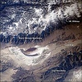
Owens Lake
Encyclopedia
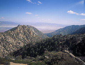
Owens Lake is a mostly dry lake
in the Owens Valley
on the eastern side of the Sierra Nevada in Inyo County, California
. It is located about 5 miles (8 km) south of Lone Pine, California
. Unlike most dry lakes in the Basin and Range Province that have been dry for thousands of years, Owens held significant water until 1924, until much of the Owens River
was diverted into the Los Angeles Aqueduct
, causing it to desiccate. Today, some of the flow of the river has been restored, and the lake now contains some water.
.
It is thought that in the late Pleistocene
about 11-12,000 years ago Owens Lake was even larger, covering nearly 200 mi2 and reaching a depth of 200 feet (61 m). The increased inflow from the Owens River, from melting glaciers of the post-Ice Age
Sierra Nevada, caused Owens Lake to overflow south through Rose Valley into another now-dry lakebed, China Lake, in the Indian Wells Valley
near Ridgecrest, California
. After the glaciers melted, the lake waters receded, and this accelerated with human exploitation of the lake even before the Los Angeles Aqueduct was built, due to Owens Valley farmers who had already appropriated most of the Owens River's tributaries flow, causing the lake level to drop slightly each year.
Starting in 1913, the river and streams that fed Owens Lake were diverted by Los Angeles Department of Water and Power
(LADWP) into the Los Angeles Aqueduct
, and the lake level started to drop quickly. As the lake dried, soda processing at Keeler
switched from relatively cheap chemical methods to more expensive physical ones. The Natural Soda Products Company sued the city of Los Angeles and built a new plant with a $15,000 settlement. A fire destroyed this plant shortly after it was built but the company rebuilt it on the dry lakebed in the 1920s.
During the unusually wet winter of 1937, LADWP diverted water from the aqueduct
into the lakebed, flooding the soda plant. Because of this the courts ordered the city to pay $154,000. After an unsuccessful appeal attempt to the state supreme court in 1941, LADWP built the Long Valley Dam, which impounded Lake Crowley for flood control
.
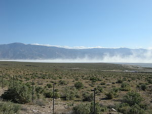
 The lake is currently a large salt flat whose surface is made of a mixture of clay
, sand
, and a variety of mineral
s including halite
, mirabilite
, thenardite
, and trona
. In wet years, these minerals form a chemical soup in the form of a small brine
pond within the dry lake. When conditions are right, bright pink halophilic (salt-loving) archaea
spread across the salty lakebed. Also, on especially hot summer days when ground temperatures exceed 150° F
(66 °C), water is driven out of the hydrate
s on the lakebed creating a muddy brine. More commonly, periodic wind
s stir up noxious alkali dust storm
s that carry away as much as four million tons (3.6 million metric tons) of dust from the lakebed each year, causing respiratory problems in nearby residents.
 As part of an air quality mitigation settlement, LADWP is currently shallow flooding 27 square miles (69.9 km²) of the salt pan to help minimize alkali dust storms and further adverse health effects. There is also about 3.5 square miles (9.1 km²) of managed vegetation being used as a dust control measure. The vegetation consists of saltgrass, which is a native perennial grass highly tolerant of the salt and boron levels in the lake sediments.
lake was a very important feeding and resting stop for millions of waterfowl
each year. During a visit to Owens Lake in 1917, Joseph Grinnell
from the Museum of Vertebrate Zoology in Berkeley reported, “Great numbers of water birds are in sight along the lake shore--avocets, phalaropes, ducks. Large flocks of shorebirds in flight over the water in the distance, wheeling about show in mass, now silvery now dark, against the gray-blue of the water. There must be literally thousands of birds within sight of this one spot.”
Owens Lake is still considered to be a Nationally Significant Bird Area by the Audubon California even though Owens is now a mostly dry lake. At the shore, a chain of wetland
s, fed by springs and artesian wells, keep part of the former Owens Lake ecosystem
alive. Snowy Plover
s nest at Owens along with several thousand Snow Geese
and duck
s. As a result of current dust mitigation efforts, shallow flooding of the lakebed has created both shallow and deeper (about 3 foot (0.9144 m) deep) habitats on the lakebed. This water, although seasonally applied, is helping to buoy the lake's ecosystem causing hope in conservationists that an expanded shallow flooding program could do even more. There are no serious plans, however, to restore Owens to anything resembling a conventional lake.
On April 19, 2008, the Eastern Sierra Audubon Society, Audubon California, and the Owens Valley Committee held the first lake-wide survey of the bird populations of Owens Lake. Volunteers recorded a total of 112 avian species and 45,650 individual birds — the highest total number of birds ever officially recorded at Owens Lake. Volunteers identified 15 species of waterfowl (ducks and geese) and 22 species of shorebirds. The highest totals for individuals of a species included 13,873 California Gull
s (an inland nester at Mono Lake
and elsewhere); 9,218 American Avocet
s; 1,767 Eared Grebes; 13,826 ‘Peeps’ or small Sandpipers such as Dunlin
, Western and Least Sandpiper
s; and 2,882 individual ducks.
, below the Sierra Nevada near present day Olancha, California
, was the western shipping port
for the Cerro Gordo Mines
production and transported goods across Owens Lake with the northern ports of Swansea
and Keeler
directly below the mines. From Cartago a barge-like vessel, the Bessie Brady, was launched in 1872, which cut the three-day freight journey around the lake down to three hours.
Much of the freight it carried was silver and lead bullion from the Cerro Gordo mines, which at their height were so productive that the bars of the refined metal
s waited in large stacks before twenty-mule team teamsters could haul it to Los Angeles. The trying three-week (one way) journey improved after the formation of the Cerro Gordo Freighting Company, run by ancestors of regional historian Remi Nadeau
who has written of this period.
The town of Keeler
, below the Inyo Mountains
on the former north shore, replaced Swansea as the shipping port for the mines after the 1872 Lone Pine earthquake
. In the 1870s it had a population of 5,000 people as the center of trade
for the Cerro Gordo mines.
The Cottonwood Charcoal Kilns, traditional stone masonry 'beehive' charcoal kiln
s, were built to transform wood from trees in Cottonwood Canyon above the lake into charcoal
, to feed the Cerro Gordo mines' silver
and lead
smelter
s across the lake at Swansea. The ruins are located on the southern side of the lakebed near Cartago. They were similar to the nearby Panamint Charcoal Kilns near Death Valley
. The kilns are identified as California Historical Landmark
#537.
built narrow-gauge rail tracks to the town. It then became a soda, salt
, and marble
shipping center until 1960. The rail line had been sold to Southern Pacific Railroad
in 1900. Keeler's current population is around 50 people and continues in decline.
In the 20th century, the Clark Chemical Company operated on the northwestern shore at Bartlett
, with evaporation pond
s for lake brine
and a plant to extract its chemicals.
is using mitigation funds from CalTrans to enhance habitat. This property continues to develop as a wildlife-viewing area for the public. The site is open year-round for viewing of numerous bird species attracted to the ponds and wetlands as well as the ruins of a historic soda ash plant from the World War I
era and the 1920s.
Dry lake
Dry lakes are ephemeral lakebeds, or a remnant of an endorheic lake. Such flats consist of fine-grained sediments infused with alkali salts. Dry lakes are also referred to as alkali flats, sabkhas, playas or mud flats...
in the Owens Valley
Owens Valley
Owens Valley is the arid valley of the Owens River in eastern California in the United States, to the east of the Sierra Nevada and west of the White Mountains and Inyo Mountains on the west edge of the Great Basin section...
on the eastern side of the Sierra Nevada in Inyo County, California
Inyo County, California
-National protected areas:* Death Valley National Park * Inyo National Forest * Manzanar National Historic Site-Major highways:* U.S. Route 6* U.S. Route 395* State Route 127* State Route 136* State Route 168* State Route 178...
. It is located about 5 miles (8 km) south of Lone Pine, California
Lone Pine, California
Lone Pine is a census-designated place in Inyo County, California, United States. Lone Pine is located south-southeast of Independence, at an elevation of 3727 feet . The population was 2,035 at the 2010 census, up from 1,655 at the 2000 census. The town is located in the Owens Valley, near the...
. Unlike most dry lakes in the Basin and Range Province that have been dry for thousands of years, Owens held significant water until 1924, until much of the Owens River
Owens River
The Owens River is a river in southeastern California in the United States, approximately long. It drains into and through the Owens Valley, an arid basin between the eastern slope of the Sierra Nevada and the western faces of the Inyo and White Mountains. The river terminates at Owens Lake, but...
was diverted into the Los Angeles Aqueduct
Los Angeles Aqueduct
The Los Angeles Aqueduct system comprising the Los Angeles Aqueduct and the Second Los Angeles Aqueduct, is a water conveyance system operated by the Los Angeles Department of Water and Power...
, causing it to desiccate. Today, some of the flow of the river has been restored, and the lake now contains some water.
History
Before the diversion of the Owens River, Owens Lake was up to 12 miles (19.3 km) long and 8 miles (12.9 km) wide, covering an area of up to 108 mi2. In the last few hundred years the lake had an average depth of 23 to 50 ft (7 to 15.2 m), and sometimes overflowed to the south upon which the water would flow into the Mojave DesertMojave Desert
The Mojave Desert occupies a significant portion of southeastern California and smaller parts of central California, southern Nevada, southwestern Utah and northwestern Arizona, in the United States...
.
It is thought that in the late Pleistocene
Pleistocene
The Pleistocene is the epoch from 2,588,000 to 11,700 years BP that spans the world's recent period of repeated glaciations. The name pleistocene is derived from the Greek and ....
about 11-12,000 years ago Owens Lake was even larger, covering nearly 200 mi2 and reaching a depth of 200 feet (61 m). The increased inflow from the Owens River, from melting glaciers of the post-Ice Age
Ice age
An ice age or, more precisely, glacial age, is a generic geological period of long-term reduction in the temperature of the Earth's surface and atmosphere, resulting in the presence or expansion of continental ice sheets, polar ice sheets and alpine glaciers...
Sierra Nevada, caused Owens Lake to overflow south through Rose Valley into another now-dry lakebed, China Lake, in the Indian Wells Valley
Indian Wells Valley
Indian Wells Valley is an arid north-south basin in east-central California. In the geologic sense, it is a southern extension of Owens Valley to the north, with the recent volcanics of the Coso Range being the separator...
near Ridgecrest, California
Ridgecrest, California
Ridgecrest, formerly known as Crumville, was incorporated as a city in 1913. It is located in the Indian Wells Valley in northeastern Kern County, California, adjacent to the Naval Air Weapons Station China Lake . Ridgecrest is the only incorporated city along US 395 in Kern County...
. After the glaciers melted, the lake waters receded, and this accelerated with human exploitation of the lake even before the Los Angeles Aqueduct was built, due to Owens Valley farmers who had already appropriated most of the Owens River's tributaries flow, causing the lake level to drop slightly each year.
Starting in 1913, the river and streams that fed Owens Lake were diverted by Los Angeles Department of Water and Power
Los Angeles Department of Water and Power
The Los Angeles Department of Water and Power is the largest municipal utility in the United States, serving over four million residents. It was founded in 1902 to supply water and electricity to residents and businesses in Los Angeles and surrounding communities...
(LADWP) into the Los Angeles Aqueduct
Los Angeles Aqueduct
The Los Angeles Aqueduct system comprising the Los Angeles Aqueduct and the Second Los Angeles Aqueduct, is a water conveyance system operated by the Los Angeles Department of Water and Power...
, and the lake level started to drop quickly. As the lake dried, soda processing at Keeler
Keeler, California
Keeler is a census-designated place in Inyo County, California, United States. Keeler is located on the east shore of Owens Lake south-southeast of New York Butte, at an elevation of 3602 feet...
switched from relatively cheap chemical methods to more expensive physical ones. The Natural Soda Products Company sued the city of Los Angeles and built a new plant with a $15,000 settlement. A fire destroyed this plant shortly after it was built but the company rebuilt it on the dry lakebed in the 1920s.
During the unusually wet winter of 1937, LADWP diverted water from the aqueduct
Aqueduct
An aqueduct is a water supply or navigable channel constructed to convey water. In modern engineering, the term is used for any system of pipes, ditches, canals, tunnels, and other structures used for this purpose....
into the lakebed, flooding the soda plant. Because of this the courts ordered the city to pay $154,000. After an unsuccessful appeal attempt to the state supreme court in 1941, LADWP built the Long Valley Dam, which impounded Lake Crowley for flood control
Flood control
In communications, flood control is a feature of many communication protocols designed to prevent overwhelming of a destination receiver. Such controls can be implemented either in software or in hardware, and will often request that the message be resent after the receiver has finished...
.
Current conditions
Clay
Clay is a general term including many combinations of one or more clay minerals with traces of metal oxides and organic matter. Geologic clay deposits are mostly composed of phyllosilicate minerals containing variable amounts of water trapped in the mineral structure.- Formation :Clay minerals...
, sand
Sand
Sand is a naturally occurring granular material composed of finely divided rock and mineral particles.The composition of sand is highly variable, depending on the local rock sources and conditions, but the most common constituent of sand in inland continental settings and non-tropical coastal...
, and a variety of mineral
Mineral
A mineral is a naturally occurring solid chemical substance formed through biogeochemical processes, having characteristic chemical composition, highly ordered atomic structure, and specific physical properties. By comparison, a rock is an aggregate of minerals and/or mineraloids and does not...
s including halite
Halite
Halite , commonly known as rock salt, is the mineral form of sodium chloride . Halite forms isometric crystals. The mineral is typically colorless or white, but may also be light blue, dark blue, purple, pink, red, orange, yellow or gray depending on the amount and type of impurities...
, mirabilite
Mirabilite
Mirabilite, also known as Glauber's salt, is a hydrous sodium sulfate mineral with the chemical formula Na2SO4·10H2O. It is a vitreous, colorless to white monoclinic mineral which forms as an evaporite from sodium sulfate bearing brines. It is found around saline springs and along saline playa lakes...
, thenardite
Thenardite
Thenardite is an anhydrous sodium sulfate mineral, Na2SO4 which occurs in arid evaporite environments. It also occurs in dry caves and old mine workings as an efflorescence and as a crusty deposit around fumaroles. It occurs in volcanic caves on Mt...
, and trona
Trona
Trona ; Na3•2H2O is an evaporite mineral. It is mined as the primary source of sodium carbonate in the United States, where it has replaced the Solvay process used in most of the rest of the world for sodium carbonate production.- Etymology :The word "trona" comes to English by way of either...
. In wet years, these minerals form a chemical soup in the form of a small brine
Brine
Brine is water, saturated or nearly saturated with salt .Brine is used to preserve vegetables, fruit, fish, and meat, in a process known as brining . Brine is also commonly used to age Halloumi and Feta cheeses, or for pickling foodstuffs, as a means of preserving them...
pond within the dry lake. When conditions are right, bright pink halophilic (salt-loving) archaea
Archaea
The Archaea are a group of single-celled microorganisms. A single individual or species from this domain is called an archaeon...
spread across the salty lakebed. Also, on especially hot summer days when ground temperatures exceed 150° F
Fahrenheit
Fahrenheit is the temperature scale proposed in 1724 by, and named after, the German physicist Daniel Gabriel Fahrenheit . Within this scale, the freezing of water into ice is defined at 32 degrees, while the boiling point of water is defined to be 212 degrees...
(66 °C), water is driven out of the hydrate
Hydrate
Hydrate is a term used in inorganic chemistry and organic chemistry to indicate that a substance contains water. The chemical state of the water varies widely between hydrates, some of which were so labeled before their chemical structure was understood....
s on the lakebed creating a muddy brine. More commonly, periodic wind
Wind
Wind is the flow of gases on a large scale. On Earth, wind consists of the bulk movement of air. In outer space, solar wind is the movement of gases or charged particles from the sun through space, while planetary wind is the outgassing of light chemical elements from a planet's atmosphere into space...
s stir up noxious alkali dust storm
Dust storm
A dust / sand storm is a meteorological phenomenon common in arid and semi-arid regions. Dust storms arise when a gust front or other strong wind blows loose sand and dirt from a dry surface. Particles are transported by saltation and suspension, causing soil to move from one place and deposition...
s that carry away as much as four million tons (3.6 million metric tons) of dust from the lakebed each year, causing respiratory problems in nearby residents.
Current management
Ecology
This once-blue, salineSalinity
Salinity is the saltiness or dissolved salt content of a body of water. It is a general term used to describe the levels of different salts such as sodium chloride, magnesium and calcium sulfates, and bicarbonates...
lake was a very important feeding and resting stop for millions of waterfowl
Waterfowl
Waterfowl are certain wildfowl of the order Anseriformes, especially members of the family Anatidae, which includes ducks, geese, and swans....
each year. During a visit to Owens Lake in 1917, Joseph Grinnell
Joseph Grinnell
Joseph Grinnell was a field biologist and zoologist. He made extensive studies of the fauna of California, and is credited with introducing a method of recording precise field observations known as the Grinnell System...
from the Museum of Vertebrate Zoology in Berkeley reported, “Great numbers of water birds are in sight along the lake shore--avocets, phalaropes, ducks. Large flocks of shorebirds in flight over the water in the distance, wheeling about show in mass, now silvery now dark, against the gray-blue of the water. There must be literally thousands of birds within sight of this one spot.”
Owens Lake is still considered to be a Nationally Significant Bird Area by the Audubon California even though Owens is now a mostly dry lake. At the shore, a chain of wetland
Wetland
A wetland is an area of land whose soil is saturated with water either permanently or seasonally. Wetlands are categorised by their characteristic vegetation, which is adapted to these unique soil conditions....
s, fed by springs and artesian wells, keep part of the former Owens Lake ecosystem
Ecosystem
An ecosystem is a biological environment consisting of all the organisms living in a particular area, as well as all the nonliving , physical components of the environment with which the organisms interact, such as air, soil, water and sunlight....
alive. Snowy Plover
Snowy Plover
The Snowy Plover is a small wader in the plover bird family. It breeds in Ecuador, Peru, Chile, the southern and western USA and the Caribbean...
s nest at Owens along with several thousand Snow Geese
Snow Goose
The Snow Goose , also known as the Blue Goose, is a North American species of goose. Its name derives from the typically white plumage. The genus of this bird is disputed...
and duck
Duck
Duck is the common name for a large number of species in the Anatidae family of birds, which also includes swans and geese. The ducks are divided among several subfamilies in the Anatidae family; they do not represent a monophyletic group but a form taxon, since swans and geese are not considered...
s. As a result of current dust mitigation efforts, shallow flooding of the lakebed has created both shallow and deeper (about 3 foot (0.9144 m) deep) habitats on the lakebed. This water, although seasonally applied, is helping to buoy the lake's ecosystem causing hope in conservationists that an expanded shallow flooding program could do even more. There are no serious plans, however, to restore Owens to anything resembling a conventional lake.
On April 19, 2008, the Eastern Sierra Audubon Society, Audubon California, and the Owens Valley Committee held the first lake-wide survey of the bird populations of Owens Lake. Volunteers recorded a total of 112 avian species and 45,650 individual birds — the highest total number of birds ever officially recorded at Owens Lake. Volunteers identified 15 species of waterfowl (ducks and geese) and 22 species of shorebirds. The highest totals for individuals of a species included 13,873 California Gull
California Gull
The California Gull Larus californicus is a medium-sized gull, smaller on average than the Herring Gull but larger on average than the Ring-billed Gull, though may overlap in size greatly with both....
s (an inland nester at Mono Lake
Mono Lake
Mono Lake is a large, shallow saline lake in Mono County, California, formed at least 760,000 years ago as a terminal lake in a basin that has no outlet to the ocean...
and elsewhere); 9,218 American Avocet
American Avocet
The American Avocet is a large wader in the avocet and stilt family, Recurvirostridae.This avocet has long, thin, gray legs, giving it its colloquial name, "blue shanks". The plumage is black and white on the back with white on the underbelly. The neck and head are cinnamon colored in the summer...
s; 1,767 Eared Grebes; 13,826 ‘Peeps’ or small Sandpipers such as Dunlin
Dunlin
The Dunlin, Calidris alpina, is a small wader, sometimes separated with the other "stints" in Erolia. It is a circumpolar breeder in Arctic or subarctic regions. Birds that breed in northern Europe and Asia are long-distance migrants, wintering south to Africa, southeast Asia and the Middle East...
, Western and Least Sandpiper
Least Sandpiper
The Least Sandpiper is the smallest shorebird.This species has greenish legs and a short thin dark bill. Breeding adults are brown with dark brown streaks on top and white underneath. They have a light line above the eye and a dark crown. In winter, Least Sandpipers are grey above...
s; and 2,882 individual ducks.
Cerro Gordo Mines
The town of CartagoCartago, California
Cartago is a census-designated place in Inyo County, California, United States. Cartago is located on the west side of Owens Lake north-northwest of Olancha, at an elevation of 3629 feet...
, below the Sierra Nevada near present day Olancha, California
Olancha, California
Olancha is a census-designated place in Inyo County of the U.S. state of California. Olancha is located on U.S. Route 395 in California, south-southeast of Independence, at an elevation of 3658 feet...
, was the western shipping port
Harbor
A harbor or harbour , or haven, is a place where ships, boats, and barges can seek shelter from stormy weather, or else are stored for future use. Harbors can be natural or artificial...
for the Cerro Gordo Mines
Cerro Gordo Mines
The Cerro Gordo Mines were a collection of mines located in the Inyo Mountains, in Inyo County, California. Mining operations were undertaken from 1866 until 1957, producing high grade silver, lead, and zinc ore. Some ore was smelted on site, however the remote location led to larger scale...
production and transported goods across Owens Lake with the northern ports of Swansea
Swansea, California
Swansea is an unincorporated community in Inyo County, California. It is located south of New York Butte, at an elevation of 3661 feet .Swansea was a boomtown located on the eastern shore of Owens Lake...
and Keeler
Keeler, California
Keeler is a census-designated place in Inyo County, California, United States. Keeler is located on the east shore of Owens Lake south-southeast of New York Butte, at an elevation of 3602 feet...
directly below the mines. From Cartago a barge-like vessel, the Bessie Brady, was launched in 1872, which cut the three-day freight journey around the lake down to three hours.
Much of the freight it carried was silver and lead bullion from the Cerro Gordo mines, which at their height were so productive that the bars of the refined metal
Metal
A metal , is an element, compound, or alloy that is a good conductor of both electricity and heat. Metals are usually malleable and shiny, that is they reflect most of incident light...
s waited in large stacks before twenty-mule team teamsters could haul it to Los Angeles. The trying three-week (one way) journey improved after the formation of the Cerro Gordo Freighting Company, run by ancestors of regional historian Remi Nadeau
Remi Nadeau
Remi Nadeau is an American historian. He earned a bachelor's degree from Stanford University and a PhD from the University of California at Santa Barbara.-Publications:* City Makers * The Water Seekers...
who has written of this period.
The town of Keeler
Keeler, California
Keeler is a census-designated place in Inyo County, California, United States. Keeler is located on the east shore of Owens Lake south-southeast of New York Butte, at an elevation of 3602 feet...
, below the Inyo Mountains
Inyo Mountains
The Inyo Mountains are a short mountain range east of the Sierra Nevada mountains in eastern California in the United States. The range separates the Owens Valley to the west with Saline Valley to the east, extending for approximately 70 mi SSE from the southern end of the White Mountains,...
on the former north shore, replaced Swansea as the shipping port for the mines after the 1872 Lone Pine earthquake
1872 Lone Pine earthquake
The Great Lone Pine earthquake was one of the largest earthquakes to hit California in recorded history. The quake struck on March 26, 1872 and its epicenter was near Lone Pine, California in Owens Valley...
. In the 1870s it had a population of 5,000 people as the center of trade
Trade
Trade is the transfer of ownership of goods and services from one person or entity to another. Trade is sometimes loosely called commerce or financial transaction or barter. A network that allows trade is called a market. The original form of trade was barter, the direct exchange of goods and...
for the Cerro Gordo mines.
The Cottonwood Charcoal Kilns, traditional stone masonry 'beehive' charcoal kiln
Kiln
A kiln is a thermally insulated chamber, or oven, in which a controlled temperature regime is produced. Uses include the hardening, burning or drying of materials...
s, were built to transform wood from trees in Cottonwood Canyon above the lake into charcoal
Charcoal
Charcoal is the dark grey residue consisting of carbon, and any remaining ash, obtained by removing water and other volatile constituents from animal and vegetation substances. Charcoal is usually produced by slow pyrolysis, the heating of wood or other substances in the absence of oxygen...
, to feed the Cerro Gordo mines' silver
Silver
Silver is a metallic chemical element with the chemical symbol Ag and atomic number 47. A soft, white, lustrous transition metal, it has the highest electrical conductivity of any element and the highest thermal conductivity of any metal...
and lead
Lead
Lead is a main-group element in the carbon group with the symbol Pb and atomic number 82. Lead is a soft, malleable poor metal. It is also counted as one of the heavy metals. Metallic lead has a bluish-white color after being freshly cut, but it soon tarnishes to a dull grayish color when exposed...
smelter
Smelting
Smelting is a form of extractive metallurgy; its main use is to produce a metal from its ore. This includes iron extraction from iron ore, and copper extraction and other base metals from their ores...
s across the lake at Swansea. The ruins are located on the southern side of the lakebed near Cartago. They were similar to the nearby Panamint Charcoal Kilns near Death Valley
Death Valley
Death Valley is a desert valley located in Eastern California. Situated within the Mojave Desert, it features the lowest, driest, and hottest locations in North America. Badwater, a basin located in Death Valley, is the specific location of the lowest elevation in North America at 282 feet below...
. The kilns are identified as California Historical Landmark
California Historical Landmark
California Historical Landmarks are buildings, structures, sites, or places in the state of California that have been determined to have statewide historical significance by meeting at least one of the criteria listed below:...
#537.
Other enterprises
In 1879, silver mining ended, but Keeler was saved when the Carson and Colorado RailroadCarson and Colorado Railroad
The Carson and Colorado Railway was a U.S. narrow gauge railroad that ran from Mound House, Nevada, to Keeler, California below the Cerro Gordo Mines. It was incorporated on May 10, 1880 as the Carson and Colorado Railroad, and construction on the railroad began on May 31, 1880. A track gauge of ...
built narrow-gauge rail tracks to the town. It then became a soda, salt
Salt
In chemistry, salts are ionic compounds that result from the neutralization reaction of an acid and a base. They are composed of cations and anions so that the product is electrically neutral...
, and marble
Marble
Marble is a metamorphic rock composed of recrystallized carbonate minerals, most commonly calcite or dolomite.Geologists use the term "marble" to refer to metamorphosed limestone; however stonemasons use the term more broadly to encompass unmetamorphosed limestone.Marble is commonly used for...
shipping center until 1960. The rail line had been sold to Southern Pacific Railroad
Southern Pacific Railroad
The Southern Pacific Transportation Company , earlier Southern Pacific Railroad and Southern Pacific Company, and usually simply called the Southern Pacific or Espee, was an American railroad....
in 1900. Keeler's current population is around 50 people and continues in decline.
In the 20th century, the Clark Chemical Company operated on the northwestern shore at Bartlett
Bartlett, California
Bartlett is an unincorporated community in Inyo County, California. It is located on the Southern Pacific Railroad north of Olancha, at an elevation of 3619 feet ....
, with evaporation pond
Evaporation pond
Evaporation ponds are artificial ponds with very large surface areas that are designed to efficiently evaporate water by sunlight and exposure to the ambient temperatures.- Uses :...
s for lake brine
Brine
Brine is water, saturated or nearly saturated with salt .Brine is used to preserve vegetables, fruit, fish, and meat, in a process known as brining . Brine is also commonly used to age Halloumi and Feta cheeses, or for pickling foodstuffs, as a means of preserving them...
and a plant to extract its chemicals.
Public access
At the 200 acre (0.809372 km²) Cartago Springs wetland at the foot of Owens Lake, the California Department of Fish and GameCalifornia Department of Fish and Game
The California Department of Fish and Game is a department within the government of California, falling under its parent California Natural Resources Agency. The Department of Fish and Game manages and protects the state's diverse fish, wildlife, plant resources, and native habitats...
is using mitigation funds from CalTrans to enhance habitat. This property continues to develop as a wildlife-viewing area for the public. The site is open year-round for viewing of numerous bird species attracted to the ponds and wetlands as well as the ruins of a historic soda ash plant from the World War I
World War I
World War I , which was predominantly called the World War or the Great War from its occurrence until 1939, and the First World War or World War I thereafter, was a major war centred in Europe that began on 28 July 1914 and lasted until 11 November 1918...
era and the 1920s.
See also
- Owens River courseOwens River courseThe Owens River course includes headwaters points near the Upper San Joaquin Watershed, reservoirs and diversion points , and the river's mouth at Owens Lake...
- Los Angeles AqueductLos Angeles AqueductThe Los Angeles Aqueduct system comprising the Los Angeles Aqueduct and the Second Los Angeles Aqueduct, is a water conveyance system operated by the Los Angeles Department of Water and Power...
- California Water WarsCalifornia Water WarsThe California Water Wars were a series of conflicts between the city of Los Angeles, farmers and ranchers in the Owens Valley of Eastern California, and environmentalists. As Los Angeles grew in the late 1800s, it started to outgrow its water supply. Fred Eaton, mayor of Los Angeles, realized that...
External links
- The Owens Valley Committee: Owens Lake
- Owens (Dry) Lake, California: A Human-Induced Dust Problem
- Owens Lake Dust Bedevils Keeler
- David Maisel's "The Lake Project"
- "The Eternal Dustbowl" 03/22/2006 feature article in the LA Weekly on the controversy surrounding the Los Angeles Dept. of Water and Power's environmental mitigation efforts at Owens Lake, written by Jeffrey Anderson, with photographs by Claudio Cambon.