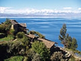
All Topics  
Lake Titicaca


   Email Print
   Bookmark   Link


Lake Titicaca


Lake Titicaca is a lake
Lake

A lake is a terrain feature , a body of liquid on the surface of a world that is localized to the bottom of basin and moves slowly if it moves at all....
 located on the border of Bolivia
Bolivia

The Republic of Bolivia , named after Sim?n Bol?var, is a landlocked country in central South America. It is bordered by Brazil on the north and east, Paraguay and Argentina on the south, and Chile and Peru on the west....
 and Peru
Peru

Peru , officially the Republic of Peru , is a country in western South America. It is bordered on the north by Ecuador and Colombia, on the east by Brazil, on the southeast by Bolivia, on the south by Chile, and on the west by the Pacific Ocean....
. It sits 3,812 m (12,500 ft) above sea level making it one of the highest commercially navigable lakes in the world. By volume of water it is also the largest lake in South America
South America

South America is the southern continent of the Americas, situated entirely in the Western Hemisphere and mostly in the Southern Hemisphere, with a relatively small portion in the Northern Hemisphere....
.

lake is located at the northern end of the endorheic
Endorheic

An endorheic basin is a closed drainage basin that retains water and allows no outflow to other bodies of water such as rivers or oceans. Normally the water accruing in drainage basins flows out through surface rivers or by underground diffusion through Permeability rock to the oceans....
 Altiplano
Altiplano

The Altiplano , in central South America, where the Andes are at their widest, is the most extensive area of high plateau on earth outside of Tibet....
 basin high in the Andes
Andes

The Andes form the world's longest exposed mountain range. They lie as a continuous chain of highland along the western coast of South America. The range is over 7,000 km long, 200-700 km wide , and of an average height of about 4,000 m ....
 on the border of Peru and Bolivia. The western part of the lake lies within the Puno Region
Puno Region

Puno is a regions of Peru in southeastern Peru. It is bordered by Bolivia on the east, the Madre de Dios Region on the north, the Cusco Region and Arequipa Region regions on the west, the Moquegua Region on the southwest, and the Tacna Region on the south....
 of Peru, and the eastern side is located in the Bolivian La Paz Department
La Paz Department (Bolivia)

The La Paz Department of Bolivia comprises with a 2001 census population of 2,350,466 inhabitants. It is situated at the western border of Bolivia, sharing Lake Titicaca with Peru....
.

The lake is composed of two nearly separate sub-basins that are connected by the Strait of Tiquina
Strait of Tiquina

The Strait of Tiquina is the passage that connects the larger and smaller parts of Lake Titicaca in Bolivia....
 which is across at the narrowest point.


Discussion
Ask a question about 'Lake Titicaca'
Start a new discussion about 'Lake Titicaca'
Answer questions from other users
Full Discussion Forum


Encyclopedia


Lake Titicaca is a lake
Lake

A lake is a terrain feature , a body of liquid on the surface of a world that is localized to the bottom of basin and moves slowly if it moves at all....
 located on the border of Bolivia
Bolivia

The Republic of Bolivia , named after Sim?n Bol?var, is a landlocked country in central South America. It is bordered by Brazil on the north and east, Paraguay and Argentina on the south, and Chile and Peru on the west....
 and Peru
Peru

Peru , officially the Republic of Peru , is a country in western South America. It is bordered on the north by Ecuador and Colombia, on the east by Brazil, on the southeast by Bolivia, on the south by Chile, and on the west by the Pacific Ocean....
. It sits 3,812 m (12,500 ft) above sea level making it one of the highest commercially navigable lakes in the world. By volume of water it is also the largest lake in South America
South America

South America is the southern continent of the Americas, situated entirely in the Western Hemisphere and mostly in the Southern Hemisphere, with a relatively small portion in the Northern Hemisphere....
.

Overview

The lake is located at the northern end of the endorheic
Endorheic

An endorheic basin is a closed drainage basin that retains water and allows no outflow to other bodies of water such as rivers or oceans. Normally the water accruing in drainage basins flows out through surface rivers or by underground diffusion through Permeability rock to the oceans....
 Altiplano
Altiplano

The Altiplano , in central South America, where the Andes are at their widest, is the most extensive area of high plateau on earth outside of Tibet....
 basin high in the Andes
Andes

The Andes form the world's longest exposed mountain range. They lie as a continuous chain of highland along the western coast of South America. The range is over 7,000 km long, 200-700 km wide , and of an average height of about 4,000 m ....
 on the border of Peru and Bolivia. The western part of the lake lies within the Puno Region
Puno Region

Puno is a regions of Peru in southeastern Peru. It is bordered by Bolivia on the east, the Madre de Dios Region on the north, the Cusco Region and Arequipa Region regions on the west, the Moquegua Region on the southwest, and the Tacna Region on the south....
 of Peru, and the eastern side is located in the Bolivian La Paz Department
La Paz Department (Bolivia)

The La Paz Department of Bolivia comprises with a 2001 census population of 2,350,466 inhabitants. It is situated at the western border of Bolivia, sharing Lake Titicaca with Peru....
.

The lake is composed of two nearly separate sub-basins that are connected by the Strait of Tiquina
Strait of Tiquina

The Strait of Tiquina is the passage that connects the larger and smaller parts of Lake Titicaca in Bolivia....
 which is across at the narrowest point. The larger sub-basin, Lago Grande (also called Lago Chucuito) has a mean depth of and a maximum depth of . The smaller sub-basin, Wiñaymarka
Wiñaymarka

File:Titicacabolivia.JPGFile:Lago Menor o Hui?amarca Per? Bolivia Satelital map 68.85829W 16.pngLake Wi?aymarka is the southern branch of Lake Titicaca in Bolivia and Peru....
 (also called Lago Pequeño, "little lake") has a mean depth of and a maximum depth of . The overall average depth of the lake is .

Lake Titicaca is fed by rainfall and meltwater from glaciers on the sierra
Sierra

Mountains and mountain ranges *Sierra mountains*Sierra Ju?rez, mountain range in Baja California, Mexico*Sierra Madre, various mountain ranges...
s that abut the Altiplano. Five major river
River

A river is a natural stream of water, usually freshwater, flowing toward an ocean, a lake, or another stream. In some cases a river flows into the ground or dries up completely before reaching another body of water....
 systems feed into Lake Titicaca—in order of their relative flow volumes these are: Ramis, Coata, Ilave, Huancané, and Suchez. More than 20 other smaller streams empty into Titicaca, and the lake has 41 islands, some of which are densely populated.

Having only a single season of free circulation, the lake is monomictic
Monomictic

Monomictic lakes are holomictic lakes that mix from top to bottom during one mixing period each year. Monomictic lakes may be subdivided into two types:...
, and water passes through Lago Huiñaimarca and flows out the single outlet at the Rio Desaguadero
Desaguadero River (Bolivia)

The Desaguadero River in Peru and Bolivia is the only river draining Lake Titicaca. It exits the lake at the southern part of the river basin, it flows south and drains approximately five percent of the lake's flood waters into Lake Poop?, a smaller lake....
, which then flows south through Bolivia to Lake Poopó. This only accounts for about 10% of the lake's water balance
Water balance

In hydrology, a water balance equation can be used to describe the flow of water in and out of a system. A system can be one of several hydrological domains, such as a column of soil or a drainage basin....
. Evapotranspiration
Evapotranspiration

Evapotranspiration is a term used to describe the sum of evaporation and plant transpiration from the earth's land surface to atmosphere. Evaporation accounts for the movement of water to the air from sources such as the soil, canopy interception, and waterbody....
, caused by strong winds and intense sunlight at altitude, balances the remaining 90% of the water input. It is nearly a closed lake.

Name

Copacabana
The origin of the name Titicaca is unknown. It has been translated as "Rock Puma
Puma

The cougar , also puma, mountain lion, or panther, depending on region, is a mammal of the Felidae family, native to the Americas....
", allegedly because of its resemblance to the shape of a puma hunting a rabbit
Rabbit

Rabbits are small mammals in the family Leporidae of the order Lagomorpha, found in several parts of the world. There are seven different genus in the family taxonomy as rabbits, including the European rabbit , Cottontail rabbit , and the Amami rabbit ....
, combining words from the local languages Quechua and Aymara
Aymara language

Aymara is an Aymaran languages language spoken by the Aymara ethnic group of the Andes. It is one of only a handful of Indigenous languages of the Americas with over a million speakers....
, and as well as translated as "Crag of Lead." Locally, the lake goes by several names. Because the southeast quarter of the lake is separate from the main body (connected only by the Strait of Tiquina
Strait of Tiquina

The Strait of Tiquina is the passage that connects the larger and smaller parts of Lake Titicaca in Bolivia....
), the Bolivians call it Lago Huiñaymarca and the larger part Lago Chucuito. In Peru, these smaller and larger parts are referred to as Lago Pequeño and Lago Grande, respectively.

Islands


Uros

Lake Titicaca
Iles Flottantes Titicaca (pixinn
Titicaca is notable for a population of people who live on the Uros
Uros

Uros are a pre-Incan people that live on 42 self-fashioned floating artificial island in Lake Titicaca Puno, Peru and Bolivia. The Uros use the Totora to make boats of bundled dried reeds, and to make the islands themselves....
, a group of 42 or so artificial island
Artificial island

An artificial island is an island that has been constructed by humans rather than formed by natural means. They are created by expanding existing islets, construction on existing reefs, or amalgamating several natural islets into a bigger island....
s made of floating reeds (totora
Totora (plant)

Totora is a subspecies of the Schoenoplectus californicus. It is found in South America - notably on Lake Titicaca - and on Easter island in the Pacific Ocean....
, a reed that abounds in the shallows of the lake). These islands have become a major tourist attraction for Peru, drawing excursions from the lakeside city of Puno
Puno

Puno is a city in southeastern Peru, located on the shore of Lake Titicaca, the world's highest navigable lake, at 3,860 m above sea level. It is also the capital and largest city of the Puno Region and the Puno Province....
. Their original purpose was defensive, and they could be moved if a threat arose. Many of the islands contain watchtowers largely constructed of reeds.

Amantaní

Amantaní
Amantaní

Amantan? is an island on the Peruvian side of Lake Titicaca. According to a 1988 census, it has a population of 3,663 Quechua speakers divided among about 800 families. The island is circular and about 9.28 km? in size....
 is another small island on Lake Titicaca populated by Quechua
Quechua

Quechua is a Native American language of South America. It was already widely spoken across the Central Andes long before the time of the Inca Empire, who established it as the official language of administration for their Empire, and is still spoken today in various regional forms by some 10 million people through much of South America, in...
 speakers. About 800 families live in six villages on the roughly circular island. There are two mountain peaks, called Pachatata (Father Earth) and Pachamama (Mother Earth), and ancient ruins on the top of both peaks. The hillsides that rise up from the lake are terraced and planted with wheat
Wheat

Wheat , is a worldwide cultivated Poaceae from the Levant region of the Middle East. Globally, after maize, wheat is the second most-produced food among the cereal just above rice....
, potatoes, and vegetables. Most of the small fields are worked by hand. Long stone fences divide the fields, and cattle, sheep, and alpaca
Alpaca

The Alpaca is a Domestication species of South American camelid. It resembles a small llama in superficial appearance.Alpacas are kept in herds that graze on the level heights of the Andes of Ecuador, southern Peru, northern Bolivia, and northern Chile at an altitude of to meters above sea-level, throughout the year....
s graze on the hillsides.
Intikawan Amantani
There are no cars on the island and no hotels. A few small stores sell basic goods, and there is a health clinic and school. Electricity was produced by a generator and provided limited to a couple of hours each day, but with the rising price of the petroleum, they no longer use the generator. Most families use candles or flashlights powered by batteries or hand-cranks.

Some of the families on Amantaní open their homes to tourists for overnight stays and provide cooked meals, arranged through tour guides. The families who do so are required to have a special room set aside for the tourists and must fit a code by the tour companies that help them. Guests typically take food staples (cooking oil, rice, sugar) as a gift or school supplies for the children on the island. They hold nightly traditional dance shows for the tourists where they offer to dress them up in their traditional clothes and participate.

Taquile

Taquile is a hilly island located 35 kilometres east of Puno. It is narrow and long and was used as a prison during the Spanish Colony and into the 20th century. In 1970 it became property of the Taquile people, who inhabit the island since then (current population around 3,000). Pre-Inca
Inca

The Inca civilization began as a tribe in the Cuzco area, where the legendary first Sapa Inca, Manco Capac founded the Kingdom of Cuzco around 1200....
 ruins are found on the highest part of the island, and agricultural terraces on hillsides.

Isla del Sol

Situated on the Bolivian side of the lake with regular boat links to the Bolivian town of Copacabana
Copacabana, Bolivia

Copacabana is the main Bolivian town on Lake Titicaca, from where boats leave for Isla del Sol, the sacred Inca island. The town has a large 16th-century shrine, the Basilica of Our Lady of Copacabana....
, Isla del Sol
Isla del Sol

Isla del Sol is an island in the southern part of Lake Titicaca. It is part of the modern Republic of Bolivia. Geographically, the terrain is harsh; it is a rocky, hilly island....
 ("Island of the sun") is one of the lake's largest islands. Geographically, the terrain is harsh; it is a rocky, hilly island. There are no motor vehicles or paved roads on the island. The main economic activity of the approximately 800 families on the island is farming, with fishing and tourism augmenting the subsistence economy.
Lake Titicaca Map
There are over 180 ruins on the island. Most of these date to the Inca period circa the 15h century AD. Many hills on the island contain agricultural terraces, which adapt steep and rocky terrain to agriculture. Among the ruins on the island are the Sacred Rock, a labyrinth-like building called Chicana, Kasa Pata, and Pilco Kaima. In the religion of the Incas, it was believed that the sun god was born here.

Isla de la Luna

Isla de la Luna is situated east from the bigger Isla del Sol. According to legends that refer to Inca mythology
Inca mythology

Inca mythology includes a number of stories and legends that are mythological and helps to explain or symbolizes Inca beliefs.All Christian priests that followed the Spanish conquest of Peru by Francisco Pizarro burned the records of the Inca culture....
 Isla de la Luna (moon in Spanish) is where Viracocha
Viracocha

In pre-Inca and Inca mythology, Apu Qun Tiqsi Wiraqutra , was the creator of civilization, and one of the most important deities in the Inca pantheon....
 commanded the rising of the moon. Ruins of a supposedly Inca nunnery occupy the oriental shore.

Suriqui

Suriqui lies in the Bolivian part of lake Titicaca (in the southeastern part also known as lake Huiñamarca).

Suriqui is thought to be the last place where the art of reed boat construction survives, at least as late as in 1998. Craftsmen from Suriqui helped Thor Heyerdahl
Thor Heyerdahl

Thor Heyerdahl was a Norway ethnographer and adventurer with a scientific background in zoology and geography. Heyerdahl became famous for his Kon-Tiki expedition, in which he sailed 4,300 miles by raft from South America to the Tuamotu Islands....
 in the construction of several of his projects, such as the reed boats Ra II and Tigris, and a balloon gondola.

Transport

A ferry connects the 1435mm gauge railway of Peru at Puno
Puno

Puno is a city in southeastern Peru, located on the shore of Lake Titicaca, the world's highest navigable lake, at 3,860 m above sea level. It is also the capital and largest city of the Puno Region and the Puno Province....
 with the 1000mm gauge railway of Bolivia at Guaqui
Guaqui

Guaqui is a railhead and port in Bolivia on Lake Titicaca. A Train ferry#Peru connects with the Peru railhead and port on Puno....
.

Miscellaneous

The Bolivian Naval Force uses the lake to carry out naval exercises, maintaining an active navy
Navy

A navy is the branch of a nation's military forces principally designated for naval warfare and amphibious warfare; namely, lake- or ocean-borne combat operations and related functions....
 despite being landlocked
Landlocked

A landlocked country is commonly defined as one enclosed or nearly enclosed by land. As of 2008, there are 44 landlocked countries in the world....
.

The partly-salt Lake Maracaibo
Lake Maracaibo

Lake Maracaibo is a large brackish bay in Venezuela at . It is connected to the Gulf of Venezuela by Tablazo Strait at the northern end, and fed by numerous rivers, the largest being the Catatumbo River....
 in Venezuela
Venezuela

Venezuela , officially the Bolivarian Republic of Venezuela , is a country on the northern coast of South America.The country comprises a continental mainland and numerous islands located off the Venezuelan coastline in the Caribbean Sea....
 is the only body of water in South America larger than Titicaca, at about .

Lake Titicaca was designated a Ramsar site (8,000km2) on August 26, 1998.

See also

  • Titicaca National Reservation
    Titicaca National Reservation

    The Titicaca National Reservation is located in the Puno Region, Peru, in the Puno Province and Huancan? Province provinces. Its main purpose is to preserve the ecosystems and landscapes of the Lake Titicaca....
  • Yampupata Peninsula
    Yampupata Peninsula

    File:Isolasol.jpgFile:Estrecho de Yampupata Mapa.svgYampupata is a Bolivian peninsula of Lake Titicaca situated north-west of Copacabana Peninsula in the La Paz Department , Manco Kapac Province, Copacabana Municipality, Bolivia, Zampaya Canton....
  • Taraco Peninsula
    Taraco

    File:Lago Menor o Hui?amarca Per? Bolivia Satelital map 68.85829W 16.pngTaraco is a peninsula jutting into Lake Wi?aymarka, the southern branch of Lake Titicaca in Bolivia....
  • Capachica Peninsula
  • Chelleca Island
  • Chiripa
    Chiripa

    The archeological site of Chiripa Pata is located in the Lake Titicaca region in Bolivia. It lays 15 km east of the city Chiripa and quite close to Pequery....


External links