

Altiplano
Encyclopedia

South America
South America is a continent situated in the Western Hemisphere, mostly in the Southern Hemisphere, with a relatively small portion in the Northern Hemisphere. The continent is also considered a subcontinent of the Americas. It is bordered on the west by the Pacific Ocean and on the north and east...
, where the Andes
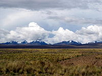
Andes
The Andes is the world's longest continental mountain range. It is a continual range of highlands along the western coast of South America. This range is about long, about to wide , and of an average height of about .Along its length, the Andes is split into several ranges, which are separated...
are at their widest, is the most extensive area of high plateau on Earth outside of Tibet
Tibet
Tibet is a plateau region in Asia, north-east of the Himalayas. It is the traditional homeland of the Tibetan people as well as some other ethnic groups such as Monpas, Qiang, and Lhobas, and is now also inhabited by considerable numbers of Han and Hui people...
. Lake Titicaca
Lake Titicaca
Lake Titicaca is a lake located on the border of Peru and Bolivia. It sits 3,811 m above sea level, making it the highest commercially navigable lake in the world...
is its best known geographical feature.
Location
The Altiplano is an area of inland drainage (endorheism) lying in the central AndesAndes
The Andes is the world's longest continental mountain range. It is a continual range of highlands along the western coast of South America. This range is about long, about to wide , and of an average height of about .Along its length, the Andes is split into several ranges, which are separated...
, occupying parts of Northern Chile
Chile
Chile ,officially the Republic of Chile , is a country in South America occupying a long, narrow coastal strip between the Andes mountains to the east and the Pacific Ocean to the west. It borders Peru to the north, Bolivia to the northeast, Argentina to the east, and the Drake Passage in the far...
and Argentina
Argentina
Argentina , officially the Argentine Republic , is the second largest country in South America by land area, after Brazil. It is constituted as a federation of 23 provinces and an autonomous city, Buenos Aires...
, Western Bolivia
Bolivia
Bolivia officially known as Plurinational State of Bolivia , is a landlocked country in central South America. It is the poorest country in South America...
and Southern Peru
Peru
Peru , officially the Republic of Peru , is a country in western South America. It is bordered on the north by Ecuador and Colombia, on the east by Brazil, on the southeast by Bolivia, on the south by Chile, and on the west by the Pacific Ocean....
. Its height averages about 3,750 meters (12,300 feet), slightly less than that of the Tibetan Plateau
Tibetan Plateau
The Tibetan Plateau , also known as the Qinghai–Tibetan Plateau is a vast, elevated plateau in Central Asia covering most of the Tibet Autonomous Region and Qinghai, in addition to smaller portions of western Sichuan, southwestern Gansu, and northern Yunnan in Western China and Ladakh in...
. Unlike conditions in Tibet, the Altiplano is dominated by massive active volcano
Volcano
2. Bedrock3. Conduit 4. Base5. Sill6. Dike7. Layers of ash emitted by the volcano8. Flank| 9. Layers of lava emitted by the volcano10. Throat11. Parasitic cone12. Lava flow13. Vent14. Crater15...
es of the Central Volcanic Zone to the west, such as Ampato
Ampato
Ampato is a dormant stratovolcano in the Andes of southern Peru, about 100 km northwest of Arequipa. It is part of a north-south chain of three major stratovolcanoes, including the extinct and eroded Nevado Hualca Hualca at the northern end and the active cone of Volcán Sabancaya in...
(6288 m), Tutupaca (5816 m), Parinacota (6348 m), Guallatiri
Guallatiri
Guallatiri is one of the most active volcanoes in northern Chile. It is just west of the border with Bolivia and at the southwestern end of the Nevados de Quimsachata. It is a symmetrical 6,071 m high ice-clad stratovolcano...
(6071 m), Cerro Paroma
Cerro Paroma
-See also:*List of mountains in the Andes...
(5728 m), Cerro Uturuncu
Uturuncu
Uturuncu, or Uturunku, the highest summit in southwestern Bolivia, is a stratovolcano. The volcano produced lava between 890,000 and 271,000 years ago, with younger lavas found at higher altitudes...
(6008 m) and Licancabur
Licancabur
Licancabur is a highly symmetrical stratovolcano on the southernmost part of the border between Chile and Bolivia. It is located just southwest of Laguna Verde in Bolivia. The volcano dominates the landscape of the Salar de Atacama area...
(5916 m), and the Cordillera Real
Cordillera Real (Bolivia)
The Cordillera Real is a mountain range in the South American Altiplano of Bolivia. This range of fold mountains, largely composed of granite, is located southeast of Lake Titicaca, and east of the Bolivian capital of La Paz, measuring 125 km in length and 20 km in width...
in the north east with Illampu
Illampu
Illampú is the fourth highest mountain in Bolivia. It is located in the northern section of the Cordillera Real, part of the Andes, east of Lake Titicaca. It lies just north of the slightly higher Ancohuma, near the town of Sorata...
(6368 m), Huayna Potosi
Huayna Potosí
Huayna Potosí is a mountain in Bolivia, located about 25 km north of La Paz in the Cordillera Real.Huayna Potosí is the closest high mountain to La Paz, a city which is surrounded by high mountains, and itself is the highest capital city in the world. Huayna Potosí is roughly fifteen miles due...
(6088 m), Ancohuma
Ancohuma
Ancohuma is the third highest mountain in Bolivia . It is located in the northern section of the Cordillera Real, part of the Andes, east of Lake Titicaca...
(6427 m) and Illimani
Illimani
Illimani is the highest mountain in the Cordillera Real of western Bolivia. It lies just south of La Paz at the eastern edge of the Altiplano. It is the second highest peak in Bolivia, after Nevado Sajama, and the eighteenth highest peak in South America...
(6438 m). The Atacama Desert
Atacama Desert
The Atacama Desert is a plateau in South America, covering a strip of land on the Pacific coast, west of the Andes mountains. It is, according to NASA, National Geographic and many other publications, the driest desert in the world...
, one of the driest areas on the planet, lies southwest of Altiplano; to the east lies the humid Amazon Rainforest
Amazon Rainforest
The Amazon Rainforest , also known in English as Amazonia or the Amazon Jungle, is a moist broadleaf forest that covers most of the Amazon Basin of South America...
.
History
At various times during the PleistocenePleistocene
The Pleistocene is the epoch from 2,588,000 to 11,700 years BP that spans the world's recent period of repeated glaciations. The name pleistocene is derived from the Greek and ....
epoch, both the southern and northern Altiplano were covered by the vast pluvial lakes. Remnants are Lake Titicaca
Lake Titicaca
Lake Titicaca is a lake located on the border of Peru and Bolivia. It sits 3,811 m above sea level, making it the highest commercially navigable lake in the world...
, straddling the Peru–Bolivia border, and Poopó, a salt lake
Salt lake
A salt lake or saline lake is a landlocked body of water which has a concentration of salts and other dissolved minerals significantly higher than most lakes . In some cases, salt lakes have a higher concentration of salt than sea water, but such lakes would also be termed hypersaline lakes...
that extends south of Oruro, Bolivia
Oruro, Bolivia
Oruro is a city in Bolivia with a population of 235,393 , located about equidistant between La Paz and Sucre at approximately 3710 meters above sea level. It is the capital of the department of Oruro....
. Salar de Uyuni
Salar de Uyuni
Salar de Uyuni is the world's largest salt flat at . It is located in the Potosí and Oruro departments in southwest Bolivia, near the crest of the Andes, and is elevated above the mean sea level. The Salar was formed as a result of transformations between several prehistoric lakes...
, locally known as Salar de Tunupa, and Salar de Coipasa are two large dry salt flats
Sink (geography)
A geographic sink is a depression within an endorheic basin where water collects with no visible outlet. Instead of discharging, the collected water is lost due to evaporation and/or penetration...
formed after the Altiplano paleolakes dried out.
Climatic zones
Climate
Climate encompasses the statistics of temperature, humidity, atmospheric pressure, wind, rainfall, atmospheric particle count and other meteorological elemental measurements in a given region over long periods...
that prevails within it: it is colder than that of the tierra fria
Tierra fría
Tierra fría is a pseudoclimatological term used in parts of Latin America to refer to mountain locations within that cultural realm, where high elevation results in a markedly cooler climate than that encountered in the lowlands at a comparable latitude.To a climatologist, the term is inaccurate,...
but not as cold as that of the tierra helada
Tierra helada
Tierra helada is a term used in Latin America to refer to the highest places found within the Andes mountains.Tierra helada is for the Montane grasslands and shrublands, Sunis, Punas and Paramos between the Treeline and the Snow line...
. Scientists classify the latter as commencing at an elevation of approximately 4,500 meters (or about 15,000 feet). Alternate names used in place of altiplano in this context include puna and páramos.
Climate
In extentum, the climate is cool and semi-arid to aridArid
A region is said to be arid when it is characterized by a severe lack of available water, to the extent of hindering or even preventing the growth and development of plant and animal life...
, with mean annual temperatures that vary from 3°C near the western mountain range to 12°C near Lake Titicaca; and total annual rain
Rain
Rain is liquid precipitation, as opposed to non-liquid kinds of precipitation such as snow, hail and sleet. Rain requires the presence of a thick layer of the atmosphere to have temperatures above the melting point of water near and above the Earth's surface...
fall that ranges between less than 200 mm to the south west to more than 800 mm near and over Lake Titicaca. The diurnal cycle of temperature is very wide, with maximum temperatures on the order of 12 to 24°C and minima on the order of -20 to 10°C. The coldest temperatures occur in the southwestern portion of the Altiplano during the months of June and July, which correspond to the Austral winter. The seasonal cycle of rainfall is marked, with the rainy season concentrated between December and March. The rest of the year tends to be very dry, cool, windy and sunny. Snow
Snow
Snow is a form of precipitation within the Earth's atmosphere in the form of crystalline water ice, consisting of a multitude of snowflakes that fall from clouds. Since snow is composed of small ice particles, it is a granular material. It has an open and therefore soft structure, unless packed by...
fall events may happen between April and September, especially to the north, but they are not very common (one to five events per year).
La Paz
La Paz
Nuestra Señora de La Paz is the administrative capital of Bolivia, as well as the departmental capital of the La Paz Department, and the second largest city in the country after Santa Cruz de la Sierra...
, Bolivia
Bolivia
Bolivia officially known as Plurinational State of Bolivia , is a landlocked country in central South America. It is the poorest country in South America...
is the Altiplano's main city.
Geology
- See also geology of BoliviaGeology of BoliviaThe geology of Bolivia compromises a variety of different lithologies as well as tectonic and sedimentary environments. On a synoptic scale, geological units coincide with topographical units, to begin the country is divided into a mountainous western area affected by the subduction processes in...
Several mechanisms have been suggested as responsible for the formation of the Altiplano plateau; theories try to explain why the topography in the Andes incorporates this large area of low relief at high altitude (high plateau) within the orogen
Orogeny
Orogeny refers to forces and events leading to a severe structural deformation of the Earth's crust due to the engagement of tectonic plates. Response to such engagement results in the formation of long tracts of highly deformed rock called orogens or orogenic belts...
:
- Existence of weaknesses in the Earth's crust prior to tectonic shortening. Such weaknesses would cause the partition of tectonic deformation and uplift into the eastern and western cordillera, leaving the necessary space for the formation of the altiplano basin.
- MagmaMagmaMagma is a mixture of molten rock, volatiles and solids that is found beneath the surface of the Earth, and is expected to exist on other terrestrial planets. Besides molten rock, magma may also contain suspended crystals and dissolved gas and sometimes also gas bubbles. Magma often collects in...
tic processes rooted in the asthenosphereAsthenosphereThe asthenosphere is the highly viscous, mechanically weak and ductilely-deforming region of the upper mantle of the Earth...
might have contributed to uplift the plateau. - Climate has controlled the spatial distribution of erosion and sediment deposition, controlling the lubrication along the Nazca PlateNazca Plate]The Nazca Plate, named after the Nazca region of southern Peru, is an oceanic tectonic plate in the eastern Pacific Ocean basin off the west coast of South America. The ongoing subduction along the Peru-Chile Trench of the Nazca Plate under the South American Plate is largely responsible for the...
subduction and hence influencing the transmission of tectonic forces into South America. - Climate also determined the formation of internal drainage (endorheism) and sediment trapping within the Andes, potentially blocking tectonic deformation in the area between the two cordilleras.
- Convective removal of dense lower lithosphere beneath the Altiplano caused that region to isostatically 'float' higher.