

Qinghai Lake
Encyclopedia
Qinghai Lake is a saline lake situated in the province of Qinghai
, and is the largest lake
in China
. The names Qinghai and Kokonor both mean "Blue/Teal Sea/Lake" in Chinese
and Mongolian
. It is located about 100 kilometres (62.1 mi) west of the provincial capital of Xining
at 3,205 m (10,515 feet) above sea level
in a depression
of the Tibetan Plateau
in the traditional Tibet
an province of Amdo
. Twenty-three rivers and streams empty into Qinghai Lake, most of them seasonal. Five permanent streams provide 80% of total influx.
The lake has fluctuated in size, shrinking over much of the 20th century, but increasing since 2004. Despite its salinity, it has an abundance of fish, such as the edible naked carp
(Gymnocypris przewalskii, huángyú (湟鱼)).
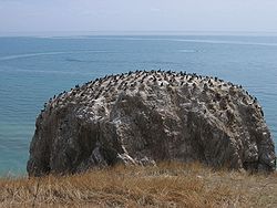
. The lake is located at the crossroads of several bird migration routes across Asia. Many species use Qinghai as an intermediate stop during migration. As such, it is a focal point in global concerns of avian influenza (H5N1
), as a major outbreak here could spread the virus across Europe and Asia, further increasing the chances of a pandemic. Minor outbreaks of H5N1 have already been identified at the lake. At the tip of the peninsula on the western side of the lake are the "Bird Islands" (Cormorant Island and Egg Island), which have been bird sanctuaries of the Qinghai Lake Natural Protection Zone since 1997. The lake often remains frozen for three months continuously in winter.
 There is an island in the western part of the lake with a temple and a few hermitages called "Mahādeva, the Heart of the Lake" (mTsho snying Ma hā de wa) which historically was home to a Buddhist monastery. No boat was used during summer, only when the lake froze over in winter could monks reach the mainland or pilgrims visit the temple - many of whom used to come from Mongolia
. A nomad described the size of the island by saying that: "if in the morning a she-goat starts to browse the grass around it clockwise and its kid anti-clockwise, they will meet only in the night, which shows how big the island is." It is also known as the place where Gushri Khan and other Qoshot Mongols migrated to during the 1620s.
The lake is also sometimes circumambulated by pilgrims from the region. Przhevalsky estimated it would take about 8 days by horse or 15 walking to circumambulate the lake, but pilgrims report it takes about 18 days on horseback, and one took 23 days walking to complete the circuit.
Chinese Muslim
General Ma Bufang
, the Governor of Qinghai, and other high ranking Qinghai and Chinese government officials attended the Kokonuur Lake Ceremony where the God of the Lake was worshipped, and during the ritual, the Chinese national Anthem was sung, all participants bowed to a Portrait of Kuomintang
party founder Dr. Sun Zhongshan, and the God of the Lake was also bowed to, and offerings were given to him by the participants, which included the Muslims. Ma Bufang invited Kazakh Muslims to attend the Ceremony honoring the God.
reported in 1998 the lake was again threatened with loss of surface area due to livestock over-grazing, land reclamations and natural causes. Lake surface area has decreased 11.7 percent in the period between 1908 and 2000 . As a result of this, or possibly moving sand dune, higher lake floors were exposed, numerous water bodies were separated from the rest of the main lake around since the 20th century. In the 1960s, the 48.9 square kilometres (18.9 sq mi) Gahai Lake (尕海, pinyin: Gǎhǎi) appeared in the northern part of the lake. During the 1980s, Shadao Lake (沙岛, pinyin: Shādǎo) split out in the northwest covers an area of 19.6 km² (7.6 sq mi), while the northeastern Haiyan Lake (海晏, pinyin: Hǎiyàn) is 112.5 km² (43.4 sq mi). Another 96.7 km² (37.3 sq mi) daughter lake split off in 2004. In addition, the lake has now split into half a dozen more small lakes at the border. The water surface has shrunk by 312 km² (120.5 sq mi) over the last three decades.
Qinghai
Qinghai ; Oirat Mongolian: ; ; Salar:) is a province of the People's Republic of China, named after Qinghai Lake...
, and is the largest lake
Lake
A lake is a body of relatively still fresh or salt water of considerable size, localized in a basin, that is surrounded by land. Lakes are inland and not part of the ocean and therefore are distinct from lagoons, and are larger and deeper than ponds. Lakes can be contrasted with rivers or streams,...
in China
China
Chinese civilization may refer to:* China for more general discussion of the country.* Chinese culture* Greater China, the transnational community of ethnic Chinese.* History of China* Sinosphere, the area historically affected by Chinese culture...
. The names Qinghai and Kokonor both mean "Blue/Teal Sea/Lake" in Chinese
Standard Chinese
Standard Chinese, or Modern Standard Chinese, also known as Mandarin or Putonghua, is the official language of the People's Republic of China and Republic of China , and is one of the four official languages of Singapore....
and Mongolian
Mongolian language
The Mongolian language is the official language of Mongolia and the best-known member of the Mongolic language family. The number of speakers across all its dialects may be 5.2 million, including the vast majority of the residents of Mongolia and many of the Mongolian residents of the Inner...
. It is located about 100 kilometres (62.1 mi) west of the provincial capital of Xining
Xining
Xining is the capital of Qinghai province, People's Republic of China, and the largest city on the Tibetan Plateau. It has 2,208,708 inhabitants at the 2010 census whom 1,198,304 live in the built up area made of 4 urban districts.-History:...
at 3,205 m (10,515 feet) above sea level
Sea level
Mean sea level is a measure of the average height of the ocean's surface ; used as a standard in reckoning land elevation...
in a depression
Depression (geology)
A depression in geology is a landform sunken or depressed below the surrounding area. Depressions may be formed by various mechanisms.Structural or tectonic related:...
of the Tibetan Plateau
Tibetan Plateau
The Tibetan Plateau , also known as the Qinghai–Tibetan Plateau is a vast, elevated plateau in Central Asia covering most of the Tibet Autonomous Region and Qinghai, in addition to smaller portions of western Sichuan, southwestern Gansu, and northern Yunnan in Western China and Ladakh in...
in the traditional Tibet
Tibet
Tibet is a plateau region in Asia, north-east of the Himalayas. It is the traditional homeland of the Tibetan people as well as some other ethnic groups such as Monpas, Qiang, and Lhobas, and is now also inhabited by considerable numbers of Han and Hui people...
an province of Amdo
Amdo
Amdo is one of the three traditional regions of Tibet, the other two being Ü-Tsang and Kham; it is also the birth place of the 14th Dalai Lama. Amdo encompasses a large area from the Machu River to the Drichu river . While culturally and ethnically a Tibetan area, Amdo has been administered by a...
. Twenty-three rivers and streams empty into Qinghai Lake, most of them seasonal. Five permanent streams provide 80% of total influx.
The lake has fluctuated in size, shrinking over much of the 20th century, but increasing since 2004. Despite its salinity, it has an abundance of fish, such as the edible naked carp
Carp
Carp are various species of oily freshwater fish of the family Cyprinidae, a very large group of fish native to Europe and Asia. The cypriniformes are traditionally grouped with the Characiformes, Siluriformes and Gymnotiformes to create the superorder Ostariophysi, since these groups have certain...
(Gymnocypris przewalskii, huángyú (湟鱼)).
Geography
Qinghai Lake is sandwiched between Hainan and Haibei Tibetan Autonomous Prefectures in northeastern QinghaiQinghai
Qinghai ; Oirat Mongolian: ; ; Salar:) is a province of the People's Republic of China, named after Qinghai Lake...
. The lake is located at the crossroads of several bird migration routes across Asia. Many species use Qinghai as an intermediate stop during migration. As such, it is a focal point in global concerns of avian influenza (H5N1
H5N1
Influenza A virus subtype H5N1, also known as "bird flu", A or simply H5N1, is a subtype of the influenza A virus which can cause illness in humans and many other animal species...
), as a major outbreak here could spread the virus across Europe and Asia, further increasing the chances of a pandemic. Minor outbreaks of H5N1 have already been identified at the lake. At the tip of the peninsula on the western side of the lake are the "Bird Islands" (Cormorant Island and Egg Island), which have been bird sanctuaries of the Qinghai Lake Natural Protection Zone since 1997. The lake often remains frozen for three months continuously in winter.
Mongolia
Mongolia is a landlocked country in East and Central Asia. It is bordered by Russia to the north and China to the south, east and west. Although Mongolia does not share a border with Kazakhstan, its western-most point is only from Kazakhstan's eastern tip. Ulan Bator, the capital and largest...
. A nomad described the size of the island by saying that: "if in the morning a she-goat starts to browse the grass around it clockwise and its kid anti-clockwise, they will meet only in the night, which shows how big the island is." It is also known as the place where Gushri Khan and other Qoshot Mongols migrated to during the 1620s.
The lake is also sometimes circumambulated by pilgrims from the region. Przhevalsky estimated it would take about 8 days by horse or 15 walking to circumambulate the lake, but pilgrims report it takes about 18 days on horseback, and one took 23 days walking to complete the circuit.
History
Before the communist revolution in China in 1949, an annual ceremony was conducted to the God of the Lake. The KuomintangKuomintang
The Kuomintang of China , sometimes romanized as Guomindang via the Pinyin transcription system or GMD for short, and translated as the Chinese Nationalist Party is a founding and ruling political party of the Republic of China . Its guiding ideology is the Three Principles of the People, espoused...
Chinese Muslim
Hui people
The Hui people are an ethnic group in China, defined as Chinese speaking people descended from foreign Muslims. They are typically distinguished by their practice of Islam, however some also practice other religions, and many are direct descendants of Silk Road travelers.In modern People's...
General Ma Bufang
Ma Bufang
Ma Bufang was a prominent Muslim Ma clique warlord in China during the Republic of China era, ruling the northwestern province of Qinghai. His rank was Lieutenant-general...
, the Governor of Qinghai, and other high ranking Qinghai and Chinese government officials attended the Kokonuur Lake Ceremony where the God of the Lake was worshipped, and during the ritual, the Chinese national Anthem was sung, all participants bowed to a Portrait of Kuomintang
Kuomintang
The Kuomintang of China , sometimes romanized as Guomindang via the Pinyin transcription system or GMD for short, and translated as the Chinese Nationalist Party is a founding and ruling political party of the Republic of China . Its guiding ideology is the Three Principles of the People, espoused...
party founder Dr. Sun Zhongshan, and the God of the Lake was also bowed to, and offerings were given to him by the participants, which included the Muslims. Ma Bufang invited Kazakh Muslims to attend the Ceremony honoring the God.
Splitting
Prior to the 1960s, 108 freshwater rivers emptied into the lake. As of 2003, 85 % of the river mouths have dried up, including the lake's largest tributary, the Buha River. In between 1959 and 1982, there had been an annual water level drop of 10 centimeters, which was reversed at a rate of 10 cm/year between 1983 to 1989, but has continued to drop since. The Chinese Academy of SciencesChinese Academy of Sciences
The Chinese Academy of Sciences , formerly known as Academia Sinica, is the national academy for the natural sciences of the People's Republic of China. It is an institution of the State Council of China. It is headquartered in Beijing, with institutes all over the People's Republic of China...
reported in 1998 the lake was again threatened with loss of surface area due to livestock over-grazing, land reclamations and natural causes. Lake surface area has decreased 11.7 percent in the period between 1908 and 2000 . As a result of this, or possibly moving sand dune, higher lake floors were exposed, numerous water bodies were separated from the rest of the main lake around since the 20th century. In the 1960s, the 48.9 square kilometres (18.9 sq mi) Gahai Lake (尕海, pinyin: Gǎhǎi) appeared in the northern part of the lake. During the 1980s, Shadao Lake (沙岛, pinyin: Shādǎo) split out in the northwest covers an area of 19.6 km² (7.6 sq mi), while the northeastern Haiyan Lake (海晏, pinyin: Hǎiyàn) is 112.5 km² (43.4 sq mi). Another 96.7 km² (37.3 sq mi) daughter lake split off in 2004. In addition, the lake has now split into half a dozen more small lakes at the border. The water surface has shrunk by 312 km² (120.5 sq mi) over the last three decades.
External links
Qinghai Lake Protection and Utilization Administration Bureau (official) Qinghai Lake Tourism and Culture Network (official)- More Birds in Qinghai Lake (Eastday.com.cn 07/17/2001)