
Quinn River
Encyclopedia
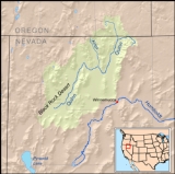
The Quinn River, once known as the Queen River, is an intermittent river, approximately 110 miles (177 km) long, in the desert of northwestern Nevada
in the United States
. It drains an enclosed basin inside the larger Great Basin
.
It rises in northeastern Humboldt County
, on the west side of the Santa Rosa Range
, just south of the Oregon
state line. Its course flows southwest, through the main Nevada lands of the Fort McDermitt Paiute and Shoshone Tribes and then south and southwest receiving the Kings River
flowing south from Kings River Valley. The Quinn River evaporates in a sink at the Black Rock Desert
approximately 60 miles (96.6 km) northwest of Winnemucca
on the Hog John Ranch of the Fort McDermitt Paiute-Shoshone Tribe.
The Quinn River is the largest river in the region, starting in the Santa Rosa Range and ending in the Quinn River Sink on the playa south of the Black Rock Range
. The watershed covers 11600 sq mi (30,043.9 km²) including the Upper and Lower Quinn River, Smoke Creek Desert
, Massacre Lake, and Thousand Creek/Virgin Valley watersheds of northwestern Nevada as well as small parts across the borders of California
and Oregon.
of ~3 square miles (7.8 km²) is where the Quinn River discharges and evaporates ~2.75 miles (4.4 km) south-southwest of Black Rock Hot Springs.
Nevada
Nevada is a state in the western, mountain west, and southwestern regions of the United States. With an area of and a population of about 2.7 million, it is the 7th-largest and 35th-most populous state. Over two-thirds of Nevada's people live in the Las Vegas metropolitan area, which contains its...
in the United States
United States
The United States of America is a federal constitutional republic comprising fifty states and a federal district...
. It drains an enclosed basin inside the larger Great Basin
Great Basin
The Great Basin is the largest area of contiguous endorheic watersheds in North America and is noted for its arid conditions and Basin and Range topography that varies from the North American low point at Badwater Basin to the highest point of the contiguous United States, less than away at the...
.
It rises in northeastern Humboldt County
Humboldt County, Nevada
Humboldt County is a county located in the U.S. state of Nevada. As of 2007, the population was estimated to be 18,052. Its county seat is Winnemucca.The county was the site of an arrest in 2000 that led to the U.S. Supreme Court decision Hiibel v...
, on the west side of the Santa Rosa Range
Santa Rosa Range
The Santa Rosa Range is a line of mountains in northern Nevada in the western United States. The range extends for approximately 75 miles north from the Humboldt River west of Winnemucca through eastern Humboldt County to the border with Oregon. The highest peaks in the range are Granite Peak ...
, just south of the Oregon
Oregon
Oregon is a state in the Pacific Northwest region of the United States. It is located on the Pacific coast, with Washington to the north, California to the south, Nevada on the southeast and Idaho to the east. The Columbia and Snake rivers delineate much of Oregon's northern and eastern...
state line. Its course flows southwest, through the main Nevada lands of the Fort McDermitt Paiute and Shoshone Tribes and then south and southwest receiving the Kings River
Kings River (Nevada)
The Kings River is a tributary of the Quinn River, about long, in northwestern Nevada and south-central Oregon in the United States. It drains a remote arid area of the northwestern Great Basin....
flowing south from Kings River Valley. The Quinn River evaporates in a sink at the Black Rock Desert
Black Rock Desert
The Black Rock Desert is an arid region in the northern Nevada section of the Great Basin with a lakebed that is a dry remnant of Pleistocene Lake Lahontan...
approximately 60 miles (96.6 km) northwest of Winnemucca
Winnemucca, Nevada
-Demographics:As of the census of 2000, there were 7,174 people, 2,736 households, and 1,824 families residing in the city. The population density was 867.5 people per square mile . There were 3,280 housing units at an average density of 396.6 per square mile...
on the Hog John Ranch of the Fort McDermitt Paiute-Shoshone Tribe.
Catchment
The Quinn River is the largest river in the region, starting in the Santa Rosa Range and ending in the Quinn River Sink on the playa south of the Black Rock Range
Black Rock Range
The Black Rock Range is a mountain range in northwestern Nevada. It is named for Black Rock Point, which is located at the southern end of the range. The Black Rock Range divides the Black Rock Desert into eastern and western arms...
. The watershed covers 11600 sq mi (30,043.9 km²) including the Upper and Lower Quinn River, Smoke Creek Desert
Smoke Creek Desert
The Smoke Creek Desert is an arid region of northwestern Nevada, USA that lies to the north of Pyramid Lake, west of the Fox Range and east of the Smoke Creek Mountains. The southern end of the desert lies on the Pyramid Lake Indian Reservation, and a rail line lies at the eastern edge...
, Massacre Lake, and Thousand Creek/Virgin Valley watersheds of northwestern Nevada as well as small parts across the borders of California
California
California is a state located on the West Coast of the United States. It is by far the most populous U.S. state, and the third-largest by land area...
and Oregon.
Quinn River Sink
The Quinn River Sink is the mouth of the Quinn River and "can hold enough water under the surface to trap unwary tourists". The geographic sinkSink (geography)
A geographic sink is a depression within an endorheic basin where water collects with no visible outlet. Instead of discharging, the collected water is lost due to evaporation and/or penetration...
of ~3 square miles (7.8 km²) is where the Quinn River discharges and evaporates ~2.75 miles (4.4 km) south-southwest of Black Rock Hot Springs.