

Altyn-Tagh
Encyclopedia
Turkic languages
The Turkic languages constitute a language family of at least thirty five languages, spoken by Turkic peoples across a vast area from Eastern Europe and the Mediterranean to Siberia and Western China, and are considered to be part of the proposed Altaic language family.Turkic languages are spoken...
; Shan is Chinese
Chinese language
The Chinese language is a language or language family consisting of varieties which are mutually intelligible to varying degrees. Originally the indigenous languages spoken by the Han Chinese in China, it forms one of the branches of Sino-Tibetan family of languages...
for mountain ; Astyn-
Tagh proper is a part of the range south of Lop Nor), is a mountain range in northwestern China that separates the eastern Tarim Basin
Tarim Basin
The Tarim Basin is a large endorheic basin occupying an area of about . It is located in the Xinjiang Uyghur Autonomous Region in China's far west. Its northern boundary is the Tian Shan mountain range and its southern is the Kunlun Mountains on the northern edge of the Tibetan Plateau. The...
from the Tibetan Plateau
Tibetan Plateau
The Tibetan Plateau , also known as the Qinghai–Tibetan Plateau is a vast, elevated plateau in Central Asia covering most of the Tibet Autonomous Region and Qinghai, in addition to smaller portions of western Sichuan, southwestern Gansu, and northern Yunnan in Western China and Ladakh in...
. The western third is in Xinjiang
Xinjiang
Xinjiang is an autonomous region of the People's Republic of China. It is the largest Chinese administrative division and spans over 1.6 million km2...
while the eastern part forms the border between Qinghai
Qinghai
Qinghai ; Oirat Mongolian: ; ; Salar:) is a province of the People's Republic of China, named after Qinghai Lake...
to the south and Xinjiang and Gansu
Gansu
' is a province located in the northwest of the People's Republic of China.It lies between the Tibetan and Huangtu plateaus, and borders Mongolia, Inner Mongolia, and Ningxia to the north, Xinjiang and Qinghai to the west, Sichuan to the south, and Shaanxi to the east...
to the north.
Altun Shan is also the name of a 5,830 metre mountain near the eastern end of the range.
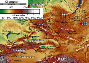
Geography
A series of mountain rangeMountain range
A mountain range is a single, large mass consisting of a succession of mountains or narrowly spaced mountain ridges, with or without peaks, closely related in position, direction, formation, and age; a component part of a mountain system or of a mountain chain...
s run along the northern edge of the Tibetan Plateau
Tibetan Plateau
The Tibetan Plateau , also known as the Qinghai–Tibetan Plateau is a vast, elevated plateau in Central Asia covering most of the Tibet Autonomous Region and Qinghai, in addition to smaller portions of western Sichuan, southwestern Gansu, and northern Yunnan in Western China and Ladakh in...
. In the west are the Kunlun Mountains
Kunlun Mountains
The Kunlun Mountains are one of the longest mountain chains in Asia, extending more than 3,000 km. In the broadest sense, it forms the northern edge of the Tibetan Plateau south of the Tarim Basin and the Gansu Corridor and continues east south of the Wei River to end at the North China Plain.The...
. About half way across the Tarim basin
Tarim Basin
The Tarim Basin is a large endorheic basin occupying an area of about . It is located in the Xinjiang Uyghur Autonomous Region in China's far west. Its northern boundary is the Tian Shan mountain range and its southern is the Kunlun Mountains on the northern edge of the Tibetan Plateau. The...
, where the mountains begin to orient somewhat to the north, the border range becomes the Altyn-Tagh, while the Kunluns continue directly east, forming a "V". Inside the "V" are a number of endorheic basins. The eastern end of the Altyn-Shan is near the Dangjin Pass on the Dunhuang
Dunhuang
Dunhuang is a city in northwestern Gansu province, Western China. It was a major stop on the ancient Silk Road. It was also known at times as Shāzhōu , or 'City of Sands', a name still used today...
-Golmud
Golmud
Golmud , sometimes transliterated as Ge'ermu or Geermu, is a county-level city in Qinghai Province, Western China. Administrated by Haixi Mongol and Tibetan Autonomous Prefecture, it is the second largest city in Qinghai and the third largest in the Tibetan Plateau . The population is now about...
road in far western Gansu
Gansu
' is a province located in the northwest of the People's Republic of China.It lies between the Tibetan and Huangtu plateaus, and borders Mongolia, Inner Mongolia, and Ningxia to the north, Xinjiang and Qinghai to the west, Sichuan to the south, and Shaanxi to the east...
. East of the Altyn-Tagh the border range rises to the Qilian Mountains.
Along the northern side of the mountains ran the main Silk road
Silk Road
The Silk Road or Silk Route refers to a historical network of interlinking trade routes across the Afro-Eurasian landmass that connected East, South, and Western Asia with the Mediterranean and European world, as well as parts of North and East Africa...
trade route from China proper
China proper
China proper or Eighteen Provinces was a term used by Western writers on the Qing Dynasty to express a distinction between the core and frontier regions of China. There is no fixed extent for China proper, as many administrative, cultural, and linguistic shifts have occurred in Chinese history...
to the Tarim Basin and westward. The Altun-Tagh and Qilians were sometimes called the Nan Shan ('south mountains') because they were south of the main route. Near the west end of the Altun-Shan the Gansu or Hexi corridor
Hexi Corridor
Hexi Corridor or Gansu Corridor refers to the historical route in Gansu province of China. As part of the Northern Silk Road running northwest from the bank of the Yellow River, it was the most important route from North China to the Tarim Basin and Central Asia for traders and the military. The...
ends and the silk road splits. One branch follows the Altun-Tagh along the south side of the Tarim Basin while the other follows the north side.
The southwestern part of the Altyn-Tagh range reaches snowy peaks of up to 6295 m, although it descends to an average of 4000 m in the narrow middle and eventually rises up to average 5000 m as it meets the Nan Shan.
Intermontane endorheic basins
Inside the "V" shaped area between the Altyn-Tagh and the main Kunlun range (which in this area is called Arka-Tagh) a number of endorheicEndorheic
An endorheic basin is a closed drainage basin that retains water and allows no outflow to other bodies of water such as rivers or oceans...
basins are located.
Within southeastern Xinjiang, the main of these basins is the Kumkol Basin
The two main lakes in this basin are the saline Lake Aqqikkol (also Ajig Kum Kul, Achak-kum; ; 37°05′N,88°25′E, 4,250 m elevation) and Lake Ayakkum ; 37°30′N,89°30′E; elevation 3,876 m). These lakes are two of the few noticeable bodies of water in this extremely arid area; the area around them is officially protected as the Altun Shan Nature Reserve.
Farther east, in northwestern Qinghai
Qinghai
Qinghai ; Oirat Mongolian: ; ; Salar:) is a province of the People's Republic of China, named after Qinghai Lake...
, the much larger Qaidam Basin starts between the Altyn-Tagh and the Kunlun and extends almost to the east side of the plateau; the Altyn-Tagh separates the west side of this basin from the Kumtagh Desert
Kumtagh Desert
The Kumtag Desert, Kumtagh Desert or Desert of Kum-tag , literally "sand mountain desert" in Old Turkic language , is an arid landform in Northwestern China, which was proclaimed as a national park in the year 2002.-Definitions:1...
.
Major Peaks
The six highest peaks are Ak Tag (6748 m), Sulamutag Feng (6245 m), Yusupu Aleketag Shan (6065 m), Altun Shan (5830 m), Muzluktag (5766 m) and Kogantag (4800 m).External links
- NASA photos of Ayakkum Lake and surrounding area