
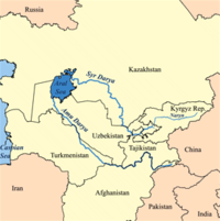
Amu Darya
Encyclopedia
The Amu Darya also called Oxus and Amu River, is a major river in Central Asia
. It is formed by the junction of the Vakhsh
and Panj
rivers. In ancient times, the river was regarded as the boundary between Iran
and Tūrān
.
 In antiquity, the river was known as Vaksu to Indo-Aryan
s.
In ancient Afghanistan, the river was also called Gozan
, descriptions of which can be found in the book "The Kingdom of Afghanistan: a historical sketch By George Passman Tate".
In classical antiquity
, the river was known as the Ōxus in Latin and Ὦξος Oxos in Greek
— a clear derivative of Vakhsh
— the name of the largest tributary of the river. In Middle Persian
sources of the Sassanid period
the river is known as Wehrōd (lit. "good river").
The name Amu is said to have come from the medieval city of Āmul, (later, Chahar Joy/Charjunow, and now known as Türkmenabat
), in modern Turkmenistan
, with Darya being the Persian word for "river".
Medieval Arabic
and Muslim
sources call the river Jayhoun (جيحون) which is derived from Gihon
, the biblical name for one of the four rivers of the Garden of Eden
.
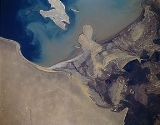
Amu Darya is a river almost in reverse, for long reputed to be sourced by a powerful glacier fed stream high in the Pamir Knot at the eastern end of Afghanistan
's Wakhan Corridor
, and ending not at the sea but spreading out into the sands of Turkmenistan's Kyzyl Kum
desert, well short of its historic terminus of the inland Aral Sea
.
 The river's total length is 2400 kilometres (1,491.3 mi) and its drainage basin totals 534739 square kilometres (206,463.9 sq mi) in area, providing a mean discharge of around 97.4 cubic kilometres (23.4 cu mi) of water per year. The river is navigable for over 1450 kilometres (901 mi). All of the water comes from the high mountains in the south where annual precipitation
can be over 1000 mm (39.4 in). Even before large-scale irrigation began, high summer evaporation meant that not all of this discharge reached the Aral Sea
- though there is some evidence the large Pamir glacier
s provided enough melt water for the Aral to overflow during the 13th and 14th centuries A.D.
One source of the Amu Darya is the Pamir River
, which emerges from Lake Zorkul
(once also known as Lake Victoria) in the Pamir Mountains
(ancient Mount Imeon
), and flows west to Qila-e Panja, where it joins the Wakhan River to form the Panj River
.
Another claimed source of the Amu Darya is an ice cave at the end of the Wakhjir valley, in the Wakhan Corridor
, in the Pamir Mountains
, near the border with Pakistan. A glacier
turns into the Wakhan River and joins the Pamir River about 50 kilometres (31.1 mi) downstream.
The Panj River forms the border of Afghanistan
and Tajikistan
. It flows west to Ishkashim where it turns north and then east north-west through the Pamirs passing the Tajik-Afghan Friendship Bridge
. It subsequently forms the border of Afghanistan and Uzbekistan
for about 200 kilometres (124.3 mi), passing Termez
and the Afghanistan-Uzbekistan Friendship Bridge. It delineates the border of Afghanistan and Turkmenistan
for another 100 kilometres (62.1 mi) before it flows into Turkmenistan at Atamyrat
. As the Amudarya, it flows across Turkmenistan south to north, passing Türkmenabat
, and forms the border of Turkmenistan and Uzbekistan
from Halkabat. It is then split into many waterways that are used to form the river delta
joining the Aral Sea, passing Urgench
, Daşoguz
and other cities, but it does not reach what is left of the sea anymore and is lost in the desert.
Use of water from the Amu Darya for irrigation
has been a major contributing factor to the shrinking of the Aral Sea since the late 1950s.
Historical records state that in different periods, the river flowed into the Aral Sea
(from the south), the Caspian Sea
(from the east) or both, similar to the Syr Darya
(Jaxartes, in Ancient Greek
).
, the southwest corner of Kyrgyzstan
, the northeast corner of Afghanistan
, a long narrow portion of western Turkmenistan
and about half of Uzbekistan
. Part of the Amu Darya's drainage divide in Tajikistan forms that country's border with China
(in the east) and Pakistan
(to the south). About 61% of the drainage lies within Tajikistan, Uzbekistan and Turkmenistan, while 39% is in Afghanistan.
Of the area drained by the Amu Darya, only about 200000 square kilometre actively contribute water to the river.
This is because many of the river's major tributaries (especially the Zeravshan River) have been diverted, and much of the river's drainage is dominated by outlying desert
and steppe
.
The abundant water flowing in the Amu Darya almost entirely comes from glacier
s in the Pamir Mountains
and Tian Shan
,
which, standing above the surrounding arid plain, collect atmospheric moisture which otherwise would probably have escaped somewhere else. Without its mountain water sources, the Amu Darya would not contain any water because it rarely rains in the lowlands that characterize most of the river. Throughout most of the steppe, the annual rainfall is about 300 millimetres (11.8 in).
s. In ancient times, the river was regarded as the boundary between Irān
and Tūrān
. The river's drainage lies in the area between the former empires of Genghis Khan
and Alexander the Great, although they occurred at much different times. One southern route of the Silk Road
ran along part of the Amu Darya northwestward from Termez
before going westwards to the Caspian Sea
.
It is believed that the Amu Darya's course across the Kara-Kum Desert has gone through several major shifts in the past few thousand years. Much of the time, the most recent period being in the 13th century to the late 16th century, the Amu Darya emptied into both the Aral and the Caspian Seas, the latter via a large distributary
called the Uzboy River
. The Uzboy splits off from the main channel just south of the Amudarya Delta. Sometimes, the flow through the two branches was more or less equal, but often, most of the Amu Darya's flow split to the west and flowed into the Caspian.
People began to settle along the lower Amu Darya and the Uzboy in the 5th century A.D., establishing a thriving chain of agricultural lands, towns, and cities. The river was impounded in about 985 A.D. at the bifurcation of the forks by the massive Gurganj Dam, which diverted water to the Aral. The dam was destroyed by Genghis Khan
's troops in 1221, and the Amu Darya shifted its flows more or less equally between the main stem and the Uzboy. But in the 18th century, the river again turned north, flowing into the Aral Sea, a path it has taken since. Less and less water flowed down the Uzboy until, in the 1720s, the river's surface flow completely dried up.
The first British explorer to reach the region in the Great Game period was a naval officer called John Wood
. He was sent on an expedition to find the source of the river in 1839. He found modern day Lake Zorkul, called it Lake Victoria and proclaimed he had found the source. Then, the French explorer and geographer Thibaut Viné collected a lot of informations about this area during five expeditions between 1856 and 1862.
The Soviet Union
became the ruling power in the 20th century. The Soviet Union fell in the 1990s and Central Asia split up into the many smaller countries that lie within or partially within the Amu Darya basin. In the 1960s and 1970s, the Amu Darya and Syr Darya were first used by the Soviets to irrigate extensive cotton
fields in the Central Asian plain. Before this time, water from the rivers was already being used for agriculture, but not on this massive scale. The Qaraqum Canal
, Karshi Canal, and Bukhara Canal were among the larger of the irrigation diversions built. The Main Turkmen Canal
was a proposed project that would have diverted water along the dry Uzboy River bed into central Turkmenistan, but was never built.
.
Central Asia
Central Asia is a core region of the Asian continent from the Caspian Sea in the west, China in the east, Afghanistan in the south, and Russia in the north...
. It is formed by the junction of the Vakhsh
Vakhsh River
The Vakhsh has been intensively developed for human use. Electricity, aluminum, and cotton are the mainstays of Tajikistan’s economy, and the Vakhsh is involved with all three of these sectors. Hydroelectricity provides 91% of the country’s electricity as of 2005, and 90% of that total comes from...
and Panj
Panj River
The Panj River , also known as Pyandzh River or Piandj River , is a tributary of the Amu Darya. The river is 1,125 km long and forms a considerable part of the Afghanistan - Tajikistan border....
rivers. In ancient times, the river was regarded as the boundary between Iran
Iran
Iran , officially the Islamic Republic of Iran , is a country in Southern and Western Asia. The name "Iran" has been in use natively since the Sassanian era and came into use internationally in 1935, before which the country was known to the Western world as Persia...
and Tūrān
Turan
Tūrān is the Persian name for Central Asia, literally meaning "the land of the Tur". As described below, the original Turanians are an Iranian tribe of the Avestan age. As a people the "Turanian" are one of the two Iranian peoples both descending from the Persian Fereydun but with different...
.
Names
Indo-Aryans
Indo-Aryan is an ethno-linguistic term referring to the wide collection of peoples united as native speakers of the Indo-Aryan branch of the Indo-Iranian family of Indo-European languages...
s.
In ancient Afghanistan, the river was also called Gozan
Gozan
Gozan may refer to:* The Ancient River Gozan, Amu Darya, The River Amu or Oxus, a river in North Afghanistan & Central Asia.* the Five Mountain System, a Japanese network of Zen temples...
, descriptions of which can be found in the book "The Kingdom of Afghanistan: a historical sketch By George Passman Tate".
In classical antiquity
Classical antiquity
Classical antiquity is a broad term for a long period of cultural history centered on the Mediterranean Sea, comprising the interlocking civilizations of ancient Greece and ancient Rome, collectively known as the Greco-Roman world...
, the river was known as the Ōxus in Latin and Ὦξος Oxos in Greek
Greek language
Greek is an independent branch of the Indo-European family of languages. Native to the southern Balkans, it has the longest documented history of any Indo-European language, spanning 34 centuries of written records. Its writing system has been the Greek alphabet for the majority of its history;...
— a clear derivative of Vakhsh
Vakhsh River
The Vakhsh has been intensively developed for human use. Electricity, aluminum, and cotton are the mainstays of Tajikistan’s economy, and the Vakhsh is involved with all three of these sectors. Hydroelectricity provides 91% of the country’s electricity as of 2005, and 90% of that total comes from...
— the name of the largest tributary of the river. In Middle Persian
Middle Persian
Middle Persian , indigenously known as "Pârsig" sometimes referred to as Pahlavi or Pehlevi, is the Middle Iranian language/ethnolect of Southwestern Iran that during Sassanid times became a prestige dialect and so came to be spoken in other regions as well. Middle Persian is classified as a...
sources of the Sassanid period
Sassanid Empire
The Sassanid Empire , known to its inhabitants as Ērānshahr and Ērān in Middle Persian and resulting in the New Persian terms Iranshahr and Iran , was the last pre-Islamic Persian Empire, ruled by the Sasanian Dynasty from 224 to 651...
the river is known as Wehrōd (lit. "good river").
The name Amu is said to have come from the medieval city of Āmul, (later, Chahar Joy/Charjunow, and now known as Türkmenabat
Türkmenabat
Türkmenabat , formerly and since the medieval times, Chardzhou , also spelled Çärjew, Chardjui, Charjou, Chardzhev, Charjev, Chärjew, or Charjew , ancient Amul, is a town in Turkmenistan, capital of Lebap Province...
), in modern Turkmenistan
Turkmenistan
Turkmenistan , formerly also known as Turkmenia is one of the Turkic states in Central Asia. Until 1991, it was a constituent republic of the Soviet Union, the Turkmen Soviet Socialist Republic . Turkmenistan is one of the six independent Turkic states...
, with Darya being the Persian word for "river".
Medieval Arabic
Arabic language
Arabic is a name applied to the descendants of the Classical Arabic language of the 6th century AD, used most prominently in the Quran, the Islamic Holy Book...
and Muslim
Muslim
A Muslim, also spelled Moslem, is an adherent of Islam, a monotheistic, Abrahamic religion based on the Quran, which Muslims consider the verbatim word of God as revealed to prophet Muhammad. "Muslim" is the Arabic term for "submitter" .Muslims believe that God is one and incomparable...
sources call the river Jayhoun (جيحون) which is derived from Gihon
Gihon
Gihon is the name of the second river mentioned in the second chapter of the biblical Book of Genesis. The Gihon is mentioned as one of four rivers issuing out of the Garden of Eden that branched from a single river within the garden. The name may be interpreted as "Bursting Forth, Gushing"...
, the biblical name for one of the four rivers of the Garden of Eden
Garden of Eden
The Garden of Eden is in the Bible's Book of Genesis as being the place where the first man, Adam, and his wife, Eve, lived after they were created by God. Literally, the Bible speaks about a garden in Eden...
.
Amu Darya is a river almost in reverse, for long reputed to be sourced by a powerful glacier fed stream high in the Pamir Knot at the eastern end of Afghanistan
Afghanistan
Afghanistan , officially the Islamic Republic of Afghanistan, is a landlocked country located in the centre of Asia, forming South Asia, Central Asia and the Middle East. With a population of about 29 million, it has an area of , making it the 42nd most populous and 41st largest nation in the world...
's Wakhan Corridor
Wakhan Corridor
Wakhan Corridor is commonly used as a synonym for Wakhan, an area of far north-eastern Afghanistan which forms a land link or "corridor" between Afghanistan and China. The Corridor is a long and slender panhandle or salient, roughly long and between wide. It separates Tajikistan in the north...
, and ending not at the sea but spreading out into the sands of Turkmenistan's Kyzyl Kum
Kyzyl Kum
The Kyzyl Kum , also called Qyzylqum, is the 11th largest desert in the world. Its name means Red Sand in Turkic languages. It is located in Central Asia in the doab between the rivers Amu Darya and Syr Darya, and is divided between Kazakhstan, Uzbekistan and Turkmenistan...
desert, well short of its historic terminus of the inland Aral Sea
Aral Sea
The Aral Sea was a lake that lay between Kazakhstan in the north and Karakalpakstan, an autonomous region of Uzbekistan, in the south...
.
In Ahadith
In the traditions of the Islamic prophet Muhammad (ahadith), the river is called by the name Jayhan (Arabic form of its ancient name Gozan).As the river Gozan
Historians tell us that one of the most ancient names for the Oxus or Amu in ancient Afghanistan was Gozan. A name used by Greek, Mongol, Chinese, Persian, Jewish and Afghan historians. However, this name is no longer used.- "Hara (Bokhara) and to the river of Gozan (that is to say, the Amu, (called by Europeans the Oxus)....".
- "the Gozan River is the River Balkh, i.e. the Oxus or the Amu Darya.....".
- "... and were brought into Halah (modern day Balkh), and Habor (which is Pesh Habor or Peshawar), and Hara (which is Herat), and to the river Gozan (which is the Ammoo, also called Jehoon)...".
Description
Precipitation (meteorology)
In meteorology, precipitation In meteorology, precipitation In meteorology, precipitation (also known as one of the classes of hydrometeors, which are atmospheric water phenomena is any product of the condensation of atmospheric water vapor that falls under gravity. The main forms of precipitation...
can be over 1000 mm (39.4 in). Even before large-scale irrigation began, high summer evaporation meant that not all of this discharge reached the Aral Sea
Aral Sea
The Aral Sea was a lake that lay between Kazakhstan in the north and Karakalpakstan, an autonomous region of Uzbekistan, in the south...
- though there is some evidence the large Pamir glacier
Glacier
A glacier is a large persistent body of ice that forms where the accumulation of snow exceeds its ablation over many years, often centuries. At least 0.1 km² in area and 50 m thick, but often much larger, a glacier slowly deforms and flows due to stresses induced by its weight...
s provided enough melt water for the Aral to overflow during the 13th and 14th centuries A.D.
One source of the Amu Darya is the Pamir River
Pamir River
The Pamir is a river in Tajikistan and Afghanistan. It is a tributary of the Panj River, and forms the northern boundary of Wakhan.The river has its sources in the Pamir Mountains in Gorno-Badakhshan province in the far eastern part of Tajikistan. It flows between the Wakhan Range and the Southern...
, which emerges from Lake Zorkul
Zorkul
Zorkul is a lake in the Pamir Mountains that runs along the border between Afghanistan and Tajikistan. It extends east to west for about 25 km. The Afghan-Tajik border runs along the lake from east to west, turning south towards Concord Peak , about 15 km south of the lake. The lake's northern...
(once also known as Lake Victoria) in the Pamir Mountains
Pamir Mountains
The Pamir Mountains are a mountain range in Central Asia formed by the junction or knot of the Himalayas, Tian Shan, Karakoram, Kunlun, and Hindu Kush ranges. They are among the world’s highest mountains and since Victorian times they have been known as the "Roof of the World" a probable...
(ancient Mount Imeon
Mount Imeon
Mount Imeon is an ancient name for the Central Asian complex of mountain ranges comprising the present Hindu Kush, Pamir and Tian Shan, extending from the Zagros Mountains in the southwest to the Altay Mountains in the northeast, and linked to the Kunlun, Karakoram and Himalayas to the southeast...
), and flows west to Qila-e Panja, where it joins the Wakhan River to form the Panj River
Panj River
The Panj River , also known as Pyandzh River or Piandj River , is a tributary of the Amu Darya. The river is 1,125 km long and forms a considerable part of the Afghanistan - Tajikistan border....
.
Another claimed source of the Amu Darya is an ice cave at the end of the Wakhjir valley, in the Wakhan Corridor
Wakhan Corridor
Wakhan Corridor is commonly used as a synonym for Wakhan, an area of far north-eastern Afghanistan which forms a land link or "corridor" between Afghanistan and China. The Corridor is a long and slender panhandle or salient, roughly long and between wide. It separates Tajikistan in the north...
, in the Pamir Mountains
Pamir Mountains
The Pamir Mountains are a mountain range in Central Asia formed by the junction or knot of the Himalayas, Tian Shan, Karakoram, Kunlun, and Hindu Kush ranges. They are among the world’s highest mountains and since Victorian times they have been known as the "Roof of the World" a probable...
, near the border with Pakistan. A glacier
Glacier
A glacier is a large persistent body of ice that forms where the accumulation of snow exceeds its ablation over many years, often centuries. At least 0.1 km² in area and 50 m thick, but often much larger, a glacier slowly deforms and flows due to stresses induced by its weight...
turns into the Wakhan River and joins the Pamir River about 50 kilometres (31.1 mi) downstream.
The Panj River forms the border of Afghanistan
Afghanistan
Afghanistan , officially the Islamic Republic of Afghanistan, is a landlocked country located in the centre of Asia, forming South Asia, Central Asia and the Middle East. With a population of about 29 million, it has an area of , making it the 42nd most populous and 41st largest nation in the world...
and Tajikistan
Tajikistan
Tajikistan , officially the Republic of Tajikistan , is a mountainous landlocked country in Central Asia. Afghanistan borders it to the south, Uzbekistan to the west, Kyrgyzstan to the north, and China to the east....
. It flows west to Ishkashim where it turns north and then east north-west through the Pamirs passing the Tajik-Afghan Friendship Bridge
Tajik-Afghan Friendship Bridge
The Tajik-Afghan Friendship Bridge connects the two banks of Darvaz across the Amu Darya river separating Tajikistan and Afghanistan, at Khorog.It was opened on 6 July 2004.- Overview :...
. It subsequently forms the border of Afghanistan and Uzbekistan
Uzbekistan
Uzbekistan , officially the Republic of Uzbekistan is a doubly landlocked country in Central Asia and one of the six independent Turkic states. It shares borders with Kazakhstan to the west and to the north, Kyrgyzstan and Tajikistan to the east, and Afghanistan and Turkmenistan to the south....
for about 200 kilometres (124.3 mi), passing Termez
Termez
Termez is a city in southern Uzbekistan near the border with Afghanistan.Some link the name of the city to thermos, "hot" in Greek, tracing its name back to Alexander the Great. Others suggest that it came from Sanskrit taramato, meaning "on the river bank". It is the hottest point of Uzbekistan...
and the Afghanistan-Uzbekistan Friendship Bridge. It delineates the border of Afghanistan and Turkmenistan
Turkmenistan
Turkmenistan , formerly also known as Turkmenia is one of the Turkic states in Central Asia. Until 1991, it was a constituent republic of the Soviet Union, the Turkmen Soviet Socialist Republic . Turkmenistan is one of the six independent Turkic states...
for another 100 kilometres (62.1 mi) before it flows into Turkmenistan at Atamyrat
Kerki
Kerki is a town in eastern Turkmenistan. It is located in Lebap Province.Nearby towns and villages include Atamyrat , Mukry , Amyderya , Surkhi and Kiikchi .....
. As the Amudarya, it flows across Turkmenistan south to north, passing Türkmenabat
Türkmenabat
Türkmenabat , formerly and since the medieval times, Chardzhou , also spelled Çärjew, Chardjui, Charjou, Chardzhev, Charjev, Chärjew, or Charjew , ancient Amul, is a town in Turkmenistan, capital of Lebap Province...
, and forms the border of Turkmenistan and Uzbekistan
Uzbekistan
Uzbekistan , officially the Republic of Uzbekistan is a doubly landlocked country in Central Asia and one of the six independent Turkic states. It shares borders with Kazakhstan to the west and to the north, Kyrgyzstan and Tajikistan to the east, and Afghanistan and Turkmenistan to the south....
from Halkabat. It is then split into many waterways that are used to form the river delta
River delta
A delta is a landform that is formed at the mouth of a river where that river flows into an ocean, sea, estuary, lake, reservoir, flat arid area, or another river. Deltas are formed from the deposition of the sediment carried by the river as the flow leaves the mouth of the river...
joining the Aral Sea, passing Urgench
Urgench
Urgench is a city in western Uzbekistan. It is the capital of the Khorezm Province, on the Amu Darya River and the Shavat canal. The city is situated 450 km west of Bukhara across the Kyzyl Kum Desert. It is located at latitude 41° 32' 60N longitude 60° 37' 60E, at an altitude of 91 meters.The...
, Daşoguz
Dasoguz
Daşoguz , formerly known as Tashauz , is a city in northern Turkmenistan and the capital of Daşoguz Province.-Geography:...
and other cities, but it does not reach what is left of the sea anymore and is lost in the desert.
Use of water from the Amu Darya for irrigation
Irrigation
Irrigation may be defined as the science of artificial application of water to the land or soil. It is used to assist in the growing of agricultural crops, maintenance of landscapes, and revegetation of disturbed soils in dry areas and during periods of inadequate rainfall...
has been a major contributing factor to the shrinking of the Aral Sea since the late 1950s.
Historical records state that in different periods, the river flowed into the Aral Sea
Aral Sea
The Aral Sea was a lake that lay between Kazakhstan in the north and Karakalpakstan, an autonomous region of Uzbekistan, in the south...
(from the south), the Caspian Sea
Caspian Sea
The Caspian Sea is the largest enclosed body of water on Earth by area, variously classed as the world's largest lake or a full-fledged sea. The sea has a surface area of and a volume of...
(from the east) or both, similar to the Syr Darya
Syr Darya
The Syr Darya , also transliterated Syrdarya or Sirdaryo, is a river in Central Asia, sometimes known as the Jaxartes or Yaxartes from its Ancient Greek name . The Greek name is derived from Old Persian, Yakhsha Arta , a reference to the color of the river's water...
(Jaxartes, in Ancient Greek
Ancient Greek
Ancient Greek is the stage of the Greek language in the periods spanning the times c. 9th–6th centuries BC, , c. 5th–4th centuries BC , and the c. 3rd century BC – 6th century AD of ancient Greece and the ancient world; being predated in the 2nd millennium BC by Mycenaean Greek...
).
Watershed
About 1385045 square kilometre of land is drained by the Amu Darya into the Aral Sea endorheic basin. This includes most of TajikistanTajikistan
Tajikistan , officially the Republic of Tajikistan , is a mountainous landlocked country in Central Asia. Afghanistan borders it to the south, Uzbekistan to the west, Kyrgyzstan to the north, and China to the east....
, the southwest corner of Kyrgyzstan
Kyrgyzstan
Kyrgyzstan , officially the Kyrgyz Republic is one of the world's six independent Turkic states . Located in Central Asia, landlocked and mountainous, Kyrgyzstan is bordered by Kazakhstan to the north, Uzbekistan to the west, Tajikistan to the southwest and China to the east...
, the northeast corner of Afghanistan
Afghanistan
Afghanistan , officially the Islamic Republic of Afghanistan, is a landlocked country located in the centre of Asia, forming South Asia, Central Asia and the Middle East. With a population of about 29 million, it has an area of , making it the 42nd most populous and 41st largest nation in the world...
, a long narrow portion of western Turkmenistan
Turkmenistan
Turkmenistan , formerly also known as Turkmenia is one of the Turkic states in Central Asia. Until 1991, it was a constituent republic of the Soviet Union, the Turkmen Soviet Socialist Republic . Turkmenistan is one of the six independent Turkic states...
and about half of Uzbekistan
Uzbekistan
Uzbekistan , officially the Republic of Uzbekistan is a doubly landlocked country in Central Asia and one of the six independent Turkic states. It shares borders with Kazakhstan to the west and to the north, Kyrgyzstan and Tajikistan to the east, and Afghanistan and Turkmenistan to the south....
. Part of the Amu Darya's drainage divide in Tajikistan forms that country's border with China
China
Chinese civilization may refer to:* China for more general discussion of the country.* Chinese culture* Greater China, the transnational community of ethnic Chinese.* History of China* Sinosphere, the area historically affected by Chinese culture...
(in the east) and Pakistan
Pakistan
Pakistan , officially the Islamic Republic of Pakistan is a sovereign state in South Asia. It has a coastline along the Arabian Sea and the Gulf of Oman in the south and is bordered by Afghanistan and Iran in the west, India in the east and China in the far northeast. In the north, Tajikistan...
(to the south). About 61% of the drainage lies within Tajikistan, Uzbekistan and Turkmenistan, while 39% is in Afghanistan.
Of the area drained by the Amu Darya, only about 200000 square kilometre actively contribute water to the river.
This is because many of the river's major tributaries (especially the Zeravshan River) have been diverted, and much of the river's drainage is dominated by outlying desert
Desert
A desert is a landscape or region that receives an extremely low amount of precipitation, less than enough to support growth of most plants. Most deserts have an average annual precipitation of less than...
and steppe
Steppe
In physical geography, steppe is an ecoregion, in the montane grasslands and shrublands and temperate grasslands, savannas, and shrublands biomes, characterized by grassland plains without trees apart from those near rivers and lakes...
.
The abundant water flowing in the Amu Darya almost entirely comes from glacier
Glacier
A glacier is a large persistent body of ice that forms where the accumulation of snow exceeds its ablation over many years, often centuries. At least 0.1 km² in area and 50 m thick, but often much larger, a glacier slowly deforms and flows due to stresses induced by its weight...
s in the Pamir Mountains
Pamir Mountains
The Pamir Mountains are a mountain range in Central Asia formed by the junction or knot of the Himalayas, Tian Shan, Karakoram, Kunlun, and Hindu Kush ranges. They are among the world’s highest mountains and since Victorian times they have been known as the "Roof of the World" a probable...
and Tian Shan
Tian Shan
The Tian Shan , also spelled Tien Shan, is a large mountain system located in Central Asia. The highest peak in the Tian Shan is Victory Peak , ....
,
which, standing above the surrounding arid plain, collect atmospheric moisture which otherwise would probably have escaped somewhere else. Without its mountain water sources, the Amu Darya would not contain any water because it rarely rains in the lowlands that characterize most of the river. Throughout most of the steppe, the annual rainfall is about 300 millimetres (11.8 in).
History
The Amu Darya was called the Oxus by the ancient GreekGreece
Greece , officially the Hellenic Republic , and historically Hellas or the Republic of Greece in English, is a country in southeastern Europe....
s. In ancient times, the river was regarded as the boundary between Irān
Greater Iran
Greater Iran refers to the regions that have significant Iranian cultural influence. It roughly corresponds to the territory on the Iranian plateau and its bordering plains, stretching from Iraq, the Caucasus, and Turkey in the west to the Indus River in the east...
and Tūrān
Turan
Tūrān is the Persian name for Central Asia, literally meaning "the land of the Tur". As described below, the original Turanians are an Iranian tribe of the Avestan age. As a people the "Turanian" are one of the two Iranian peoples both descending from the Persian Fereydun but with different...
. The river's drainage lies in the area between the former empires of Genghis Khan
Genghis Khan
Genghis Khan , born Temujin and occasionally known by his temple name Taizu , was the founder and Great Khan of the Mongol Empire, which became the largest contiguous empire in history after his death....
and Alexander the Great, although they occurred at much different times. One southern route of the Silk Road
Silk Road
The Silk Road or Silk Route refers to a historical network of interlinking trade routes across the Afro-Eurasian landmass that connected East, South, and Western Asia with the Mediterranean and European world, as well as parts of North and East Africa...
ran along part of the Amu Darya northwestward from Termez
Termez
Termez is a city in southern Uzbekistan near the border with Afghanistan.Some link the name of the city to thermos, "hot" in Greek, tracing its name back to Alexander the Great. Others suggest that it came from Sanskrit taramato, meaning "on the river bank". It is the hottest point of Uzbekistan...
before going westwards to the Caspian Sea
Caspian Sea
The Caspian Sea is the largest enclosed body of water on Earth by area, variously classed as the world's largest lake or a full-fledged sea. The sea has a surface area of and a volume of...
.
It is believed that the Amu Darya's course across the Kara-Kum Desert has gone through several major shifts in the past few thousand years. Much of the time, the most recent period being in the 13th century to the late 16th century, the Amu Darya emptied into both the Aral and the Caspian Seas, the latter via a large distributary
Distributary
A distributary, or a distributary channel, is a stream that branches off and flows away from a main stream channel. They are a common feature of river deltas. The phenomenon is known as river bifurcation. The opposite of a distributary is a tributary...
called the Uzboy River
Uzboy River
The Uzboy River was a distributary of the Amu Darya which flowed through the northwestern part of the Karakum Desert of Turkmenistan until the 18th century, when it abruptly dried up, destroying in the process the Turkmen civilization which had thrived along its banks.Now a dry river channel and a...
. The Uzboy splits off from the main channel just south of the Amudarya Delta. Sometimes, the flow through the two branches was more or less equal, but often, most of the Amu Darya's flow split to the west and flowed into the Caspian.
People began to settle along the lower Amu Darya and the Uzboy in the 5th century A.D., establishing a thriving chain of agricultural lands, towns, and cities. The river was impounded in about 985 A.D. at the bifurcation of the forks by the massive Gurganj Dam, which diverted water to the Aral. The dam was destroyed by Genghis Khan
Genghis Khan
Genghis Khan , born Temujin and occasionally known by his temple name Taizu , was the founder and Great Khan of the Mongol Empire, which became the largest contiguous empire in history after his death....
's troops in 1221, and the Amu Darya shifted its flows more or less equally between the main stem and the Uzboy. But in the 18th century, the river again turned north, flowing into the Aral Sea, a path it has taken since. Less and less water flowed down the Uzboy until, in the 1720s, the river's surface flow completely dried up.
The first British explorer to reach the region in the Great Game period was a naval officer called John Wood
John Wood (explorer)
John Wood was a Scottish naval officer, surveyor, cartographer and explorer, principally remembered for his exploration of central Asia....
. He was sent on an expedition to find the source of the river in 1839. He found modern day Lake Zorkul, called it Lake Victoria and proclaimed he had found the source. Then, the French explorer and geographer Thibaut Viné collected a lot of informations about this area during five expeditions between 1856 and 1862.
The Soviet Union
Soviet Union
The Soviet Union , officially the Union of Soviet Socialist Republics , was a constitutionally socialist state that existed in Eurasia between 1922 and 1991....
became the ruling power in the 20th century. The Soviet Union fell in the 1990s and Central Asia split up into the many smaller countries that lie within or partially within the Amu Darya basin. In the 1960s and 1970s, the Amu Darya and Syr Darya were first used by the Soviets to irrigate extensive cotton
Cotton
Cotton is a soft, fluffy staple fiber that grows in a boll, or protective capsule, around the seeds of cotton plants of the genus Gossypium. The fiber is almost pure cellulose. The botanical purpose of cotton fiber is to aid in seed dispersal....
fields in the Central Asian plain. Before this time, water from the rivers was already being used for agriculture, but not on this massive scale. The Qaraqum Canal
Qaraqum Canal
The Qaraqum Canal in Turkmenistan is one of the largest irrigation and water supply canals in the world...
, Karshi Canal, and Bukhara Canal were among the larger of the irrigation diversions built. The Main Turkmen Canal
Main Turkmen Canal
The Main Turkmen Canal was a large-scale irrigation project in Soviet Turkmenistan. The canal was intended to transport water from the Amu Darya river to Krasnovodsk , a city in Turkmenistan on the coast of the Caspian Sea...
was a proposed project that would have diverted water along the dry Uzboy River bed into central Turkmenistan, but was never built.
Literature
The Oxus river, and Arnold's poem, provide a literary background for the 1930s children's book The Far-Distant OxusThe Far-Distant Oxus
The Far-Distant Oxus is a children’s novel of 1937, written by Katharine Hull and Pamela Whitlock . The title comes from Matthew Arnold's poem Sohrab and Rustum....
.
See also
- Mount ImeonMount ImeonMount Imeon is an ancient name for the Central Asian complex of mountain ranges comprising the present Hindu Kush, Pamir and Tian Shan, extending from the Zagros Mountains in the southwest to the Altay Mountains in the northeast, and linked to the Kunlun, Karakoram and Himalayas to the southeast...
- Sherabad RiverSherabad RiverThe Sherabad River, Shirabad River or Sherabad Darya is a right tributary of the Amu Darya in south-central Tajikistan. It is about long and drains an area of . The river rises in the arid foothills of the Gissar Range and flows south through steppe before flowing through a mountain ridge to...
- Surkhan Darya
- TransoxianaTransoxianaTransoxiana is the ancient name used for the portion of Central Asia corresponding approximately with modern-day Uzbekistan, Tajikistan, southern Kyrgystan and southwest Kazakhstan. Geographically, it is the region between the Amu Darya and Syr Darya rivers...
- Zeravshan River