

Lake Eyre Basin
Encyclopedia
Drainage basin
A drainage basin is an extent or an area of land where surface water from rain and melting snow or ice converges to a single point, usually the exit of the basin, where the waters join another waterbody, such as a river, lake, reservoir, estuary, wetland, sea, or ocean...
that covers just under one-sixth of all Australia
Australia
Australia , officially the Commonwealth of Australia, is a country in the Southern Hemisphere comprising the mainland of the Australian continent, the island of Tasmania, and numerous smaller islands in the Indian and Pacific Oceans. It is the world's sixth-largest country by total area...
. The Lake Eyre Basin is the largest endorheic basin in Australia and amongst the largest in the world, covering about 1,200,000 square kilometres, including much of inland Queensland
Queensland
Queensland is a state of Australia, occupying the north-eastern section of the mainland continent. It is bordered by the Northern Territory, South Australia and New South Wales to the west, south-west and south respectively. To the east, Queensland is bordered by the Coral Sea and Pacific Ocean...
, large portions of South Australia
South Australia
South Australia is a state of Australia in the southern central part of the country. It covers some of the most arid parts of the continent; with a total land area of , it is the fourth largest of Australia's six states and two territories.South Australia shares borders with all of the mainland...
and the Northern Territory
Northern Territory
The Northern Territory is a federal territory of Australia, occupying much of the centre of the mainland continent, as well as the central northern regions...
, and a part of western New South Wales
New South Wales
New South Wales is a state of :Australia, located in the east of the country. It is bordered by Queensland, Victoria and South Australia to the north, south and west respectively. To the east, the state is bordered by the Tasman Sea, which forms part of the Pacific Ocean. New South Wales...
. The Lake Eyre basin is one of four sub-basins of the larger Great Artesian Basin
Great Artesian Basin
The Great Artesian Basin provides the only reliable source of freshwater through much of inland Australia. The basin is the largest and deepest artesian basin in the world, stretching over a total of , with temperatures measured ranging from 30°C to 100°C...
.
The deserts that have formed in the basin, including Sturt Stony Desert, Tirari Desert
Tirari Desert
The Tirari Desert is a desert in the eastern part of the Far North region of South Australia.-Location and description:The Tirari Desert features salt lakes and large north-south running sand dunes....
and the Strzelecki Desert
Strzelecki Desert
The Strzelecki Desert is located in the Far North Region of South Australia, southwest Queensland and western New South Wales. It is positioned in the northeast of the Lake Eyre Basin, and north of the Flinders Ranges. Two other deserts occupy the Lake Eyre Basin—the Tirari Desert and the...
, are most probably the southern hemisphere's largest source of airborne dust. The basin is also one of the largest, least-developed arid zone basins with high degrees of variability anywhere. Grazing
Grazing
Grazing generally describes a type of feeding, in which a herbivore feeds on plants , and also on other multicellular autotrophs...
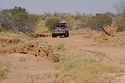
is the major land use, occupying 82% of the total land within the basin. The grazing is mostly low density due to harsh and variable climatic conditions.
The basin began as a sinking landmass
Landmass
A landmass is a contiguous area of land surrounded by ocean. Although it may be most often written as one word to distinguish it from the usage "land mass"—the measure of land area—it is also used as two words.Landmasses include:*supercontinents...
mostly covered by forest and contained many more lakes than now. The climate has changed from wet to arid over the last 60 million years. Most of the rivers in the Lake Eyre basin are now slow flowing, flat and completely dry for lengthy periods. They all flow towards the lowest point in the basin, 16 metres below sea level, at Lake Eyre
Lake Eyre
Lake Eyre is the lowest point in Australia, at approximately below sea level, and, on the rare occasions that it fills, it is the largest lake in Australia and 18th largest in the world...
. Significant mineral deposits can be found in the basin. In 2004 the Lake Eyre Basin Intergovernmental Agreement was formed after concerns with the management of four separate state governments was raised as problems in the Murray-Darling basin
Murray-Darling Basin
The Murray-Darling basin is a large geographical area in the interior of southeastern Australia, whose name is derived from its two major rivers, the Murray River and the Darling River. It drains one-seventh of the Australian land mass, and is currently by far the most significant agricultural...
arose.
Geology
The basin began to form in the early PaleogenePaleogene
The Paleogene is a geologic period and system that began 65.5 ± 0.3 and ended 23.03 ± 0.05 million years ago and comprises the first part of the Cenozoic Era...
(about 60 million years ago) when south-eastern South Australia started to sink and rivers began to deposit sediment
Sediment
Sediment is naturally occurring material that is broken down by processes of weathering and erosion, and is subsequently transported by the action of fluids such as wind, water, or ice, and/or by the force of gravity acting on the particle itself....
into the large, shallow basin. The basin is still gradually sinking, and still gradually accumulating sediment. For many millions of years, the Lake Eyre Basin was well supplied with water and largely forest
Forest
A forest, also referred to as a wood or the woods, is an area with a high density of trees. As with cities, depending where you are in the world, what is considered a forest may vary significantly in size and have various classification according to how and what of the forest is composed...
ed. About 20 million years ago, large shallow lakes formed, covering much of the area for about 10 million years. From that time on, as Australia drifted further north
Continental drift
Continental drift is the movement of the Earth's continents relative to each other. The hypothesis that continents 'drift' was first put forward by Abraham Ortelius in 1596 and was fully developed by Alfred Wegener in 1912...
and the climate became gradually more arid, the lakes and floodplains started to dry. Only in the last 2.6 million years did the onset of the ice age
Ice age
An ice age or, more precisely, glacial age, is a generic geological period of long-term reduction in the temperature of the Earth's surface and atmosphere, resulting in the presence or expansion of continental ice sheets, polar ice sheets and alpine glaciers...
s bring about the present climatic regime and the consequent fairly rapid desertification
Desertification
Desertification is the degradation of land in drylands. Caused by a variety of factors, such as climate change and human activities, desertification is one of the most significant global environmental problems.-Definitions:...
of the area.
Significant minerals deposits such as oil and natural gas, including Australia's most significant onshore petroleum reserves, are found within the basin. The mining and petroleum industries account for the greatest economic activity in the Lake Eyre Basin. Opals, coal, phosphate, gypsum and uranium are also mined from the basin. In 2009, the Queensland Environmental Protection Agency
Environmental Protection Agency (Queensland)
Queensland's Environmental Protection Agency was for some time a separate department of the Queensland Government, and, following 2009 State elections, became a part of the Government's larger Department of Environment and Resource Management.This part of the Department of Environment and...
confirmed that heavy metals from mining operations near Mount Isa had entered the upper reaches of the Georgina River. The spill has the potential to contaminate parts of the basin as far south as Lake Eyre.
Geography
Riverbed
Riverbed may refer to:*Stream bed, the channel bottom of a stream or river or creek*Wadi, a dry riverbed that contains water only during times of heavy rain*Riverbed Technology, an American technology company...
s in this vast, mostly flat, arid and semi-arid area lead inland (not towards the sea) towards Lake Eyre
Lake Eyre
Lake Eyre is the lowest point in Australia, at approximately below sea level, and, on the rare occasions that it fills, it is the largest lake in Australia and 18th largest in the world...
in central South Australia.
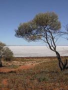
Lake Eyre itself lies approximately 16 metres below sea level
Sea level
Mean sea level is a measure of the average height of the ocean's surface ; used as a standard in reckoning land elevation...
, and usually contains only salt. In flood years it fills and for a short time undergoes a period of rapid growth and fertility: long-dormant marine creatures multiply and large flocks of waterfowl
Waterfowl
Waterfowl are certain wildfowl of the order Anseriformes, especially members of the family Anatidae, which includes ducks, geese, and swans....
arrive to feed and raise their young before the water
Water
Water is a chemical substance with the chemical formula H2O. A water molecule contains one oxygen and two hydrogen atoms connected by covalent bonds. Water is a liquid at ambient conditions, but it often co-exists on Earth with its solid state, ice, and gaseous state . Water also exists in a...
s evaporate once more.
None of the creeks
Stream
A stream is a body of water with a current, confined within a bed and stream banks. Depending on its locale or certain characteristics, a stream may be referred to as a branch, brook, beck, burn, creek, "crick", gill , kill, lick, rill, river, syke, bayou, rivulet, streamage, wash, run or...
and rivers in the Lake Eyre Basin are permanent: they flow only after heavy rain–a rare to very rare event in the arid interior of Australia. Average annual rainfall in the area surrounding Lake Eyre is 125 millimetres (5 inches), and the pan evaporation
Pan evaporation
Pan evaporation is a measurement that combines or integrates the effects of several climate elements: temperature, humidity, rain fall, drought dispersion, solar radiation, and wind. Evaporation is greatest on hot, windy, dry days; and is greatly reduced when air is cool, calm, and humid...
rate 3.5 metres (about 11 feet). Annualised average figures are misleading: since 1885 annual rainfall over the 1,100,000 square kilometres of the Lake Eyre Basin has ranged from about 45 millimetres (less than 2 inches) in 1928 to over 760 millimetres (30 inches) in 1974. Most of the water reaching Lake Eyre comes from the river systems of semi-arid inland Queensland, roughly 1000 kilometres to the north.
To provide a sense of scale, the Lake Eyre Basin is about the size of France, Germany and Italy combined. It is roughly the same size as the Murray-Darling basin
Murray-Darling Basin
The Murray-Darling basin is a large geographical area in the interior of southeastern Australia, whose name is derived from its two major rivers, the Murray River and the Darling River. It drains one-seventh of the Australian land mass, and is currently by far the most significant agricultural...
(which drains inland eastern Australia and is responsible for a large proportion of the continent's agricultural productivity
Agricultural productivity
Agricultural productivity is measured as the ratio of agricultural outputs to agricultural inputs. While individual products are usually measured by weight, their varying densities make measuring overall agricultural output difficult...
) but has vastly less water. Nevertheless, the entire flow of the Murray-Darling would be insufficient to fill Lake Eyre, merely keeping pace with evaporation. In contrast, the flow of the Mississippi
Mississippi River
The Mississippi River is the largest river system in North America. Flowing entirely in the United States, this river rises in western Minnesota and meanders slowly southwards for to the Mississippi River Delta at the Gulf of Mexico. With its many tributaries, the Mississippi's watershed drains...
could fill Lake Eyre in 22 days, that of the Amazon
Amazon River
The Amazon of South America is the second longest river in the world and by far the largest by waterflow with an average discharge greater than the next seven largest rivers combined...
in just 3 days.
Other lakes in the basin include Lake Frome
Lake Frome
Lake Frome is a large endorheic lake in South Australia, east of the Northern Flinders Ranges. It is a large, shallow, unvegetated salt pan, 100 km long and 40 km wide, lying mostly below sea level and having a total surface area of 259,615 hectares...
and Lake Hart.
Rivers
The Cooper CreekCooper Creek
Cooper Creek is one of the most famous and yet least visited rivers in Australia. It is sometimes known as the Barcoo River from one of its tributaries and is one of three major Queensland river systems that flow into the Lake Eyre Basin...
, Finke River
Finke River
The Finke River is one of the largest rivers in central Australia. Its source is in the Northern Territory's MacDonnell Ranges, and the name Finke River is first applied at the confluence of the Davenport and Ormiston Creeks, just north of Glen Helen. From here the river meanders for approximately...
, Georgina River
Georgina River
The Georgina River is the north-westernmost of the three major rivers of the Channel Country in western Queensland that flow in extremely wet years into Lake Eyre.-Geography:...
and Diamantina River
Diamantina River
The Diamantina River is a river in south west Queensland and the far north of South Australia. Rising north-west of Longreach in the Swords Range, it flows in a south-westerly direction through central Queensland and the Channel Country to form the Warburton River at its confluence with the...
are the four main rivers of the basin. Other desert rivers include the Hale River, Plenty River and Todd River
Todd River
The Todd River is an ephemeral river in the southern Northern Territory, central Australia. The origins of the Todd River begin in the MacDonnell Ranges, where it flows past the Telegraph Station, almost through the center of Alice Springs, through Heavitree Gap at the southern end of Alice Springs...
that flow from the south east of the Northern Territory, south. In the western parts of the basin the Neales River and Mackumba River flow into Lake Eyre.
Rivers within the basin have a low gradient, slow flow rate
Volumetric flow rate
The volumetric flow rate in fluid dynamics and hydrometry, is the volume of fluid which passes through a given surface per unit time...
and a naturally turbid
Turbidity
Turbidity is the cloudiness or haziness of a fluid caused by individual particles that are generally invisible to the naked eye, similar to smoke in air. The measurement of turbidity is a key test of water quality....
water quality. Several of the major Lake Eyre Basin river systems are well-known. Because the Lake Eyre Basin is almost flat, rivers flow slowly and frequently split up into floodplain
Floodplain
A floodplain, or flood plain, is a flat or nearly flat land adjacent a stream or river that stretches from the banks of its channel to the base of the enclosing valley walls and experiences flooding during periods of high discharge...
s or multiple braided channels. Water is lost to evaporation, to seepage, and in the many ephemeral wetland
Wetland
A wetland is an area of land whose soil is saturated with water either permanently or seasonally. Wetlands are categorised by their characteristic vegetation, which is adapted to these unique soil conditions....
systems, with the result that downstream flows are typically smaller than upstream flows. Only in exceptional years is there sufficient upstream rain to provide a flow into Lake Eyre itself.
The Finke River
Finke River
The Finke River is one of the largest rivers in central Australia. Its source is in the Northern Territory's MacDonnell Ranges, and the name Finke River is first applied at the confluence of the Davenport and Ormiston Creeks, just north of Glen Helen. From here the river meanders for approximately...
, starting roughly west of Alice Springs
Alice Springs, Northern Territory
Alice Springs is the second largest town in the Northern Territory of Australia. Popularly known as "the Alice" or simply "Alice", Alice Springs is situated in the geographic centre of Australia near the southern border of the Northern Territory...
is thought to be the oldest riverbed in the world and although it flows for only a few days a year (in many years it does not flow at all) is home to seven species of fish, two of which are found nowhere else. The waters of the Finke disappear into the sands of the Simpson Desert
Simpson Desert
The Simpson Desert is a large area of dry, red sandy plain and dunes in Northern Territory, South Australia and Queensland in central Australia. It is the fourth largest Australian desert, with an area of 176,500 km² ....
and are not definitely known to ever make it as far south as Lake Eyre, although the story is told that this happened once early in the 20th century.
The Georgina River
Georgina River
The Georgina River is the north-westernmost of the three major rivers of the Channel Country in western Queensland that flow in extremely wet years into Lake Eyre.-Geography:...
system originates on the Barkly Tableland, near the Northern Territory-Queensland border, north-west of Mount Isa
Mount Isa, Queensland
-Culture and sport:The local theatre group, the Mount Isa Theatrical Society, or MITS, often holds plays and musicals, at least once every few months or so....
and not far south of the Gulf of Carpentaria
Gulf of Carpentaria
The Gulf of Carpentaria is a large, shallow sea enclosed on three sides by northern Australia and bounded on the north by the Arafura Sea...
. In this relatively humid northern area, rainfall can be as high as 500 mm (20 inches) per year and evaporation as low as 2.4 metres (about 8 feet). The Georgina flows through innumerable channels leading south through far-western Queensland for over 1000 kilometres, eventually reaching Goyder Lagoon
Goyder Lagoon
Goyder Lagoon is a large ephemeral swamp in arid north-eastern South Australia. It is part of the Diamantina River floodplain, lying beside the Birdsville Track close to the state border with Queensland. Exceptionally large floods in the Georgina-Mulligan River system may contribute water to the...
in the north-eastern corner of South Australia.
Australia's early bush poet
Bush poet
Bush poets were Australian poets who wrote about Australian rural life during colonial times and about the Australian bush. Many colonial bush poets were illiterate and performed their poems from memory instead of writing them. Bush poetry evolved from the jokes and stories shared by early settlers...
s immortalised the Diamantina River
Diamantina River
The Diamantina River is a river in south west Queensland and the far north of South Australia. Rising north-west of Longreach in the Swords Range, it flows in a south-westerly direction through central Queensland and the Channel Country to form the Warburton River at its confluence with the...
, making it a symbol of the remote outback. It too rises in northern Queensland, roughly between Mount Isa
Mount Isa, Queensland
-Culture and sport:The local theatre group, the Mount Isa Theatrical Society, or MITS, often holds plays and musicals, at least once every few months or so....
and Winton
Winton, Queensland
-Qantas:Winton was one of the founding towns of the Australian airline Qantas. The first board meeting was held at the Winton Club on 10 February 1921.-Waltzing Matilda:...
, flowing 800 kilometres south and west through Birdsville
Birdsville, Queensland
-External links:*...
and the Channel Country
Channel Country
The Channel Country is region of outback Australia located mostly in the state of Queensland but also in portions of South Australia, Northern Territory and New South Wales. The name comes from the numerous intertwined rivulets that cross the region, which cover 150,000 km²...
to join the Georgina at Goyder Lagoon (and then, if there is sufficient flow, down Warburton Creek towards Lake Eyre).
Of all the Lake Eyre Basin river systems, however, Cooper Creek
Cooper Creek
Cooper Creek is one of the most famous and yet least visited rivers in Australia. It is sometimes known as the Barcoo River from one of its tributaries and is one of three major Queensland river systems that flow into the Lake Eyre Basin...
is by far the most famous, in particular because it was along Cooper Creek that the explorers Burke and Wills met their deaths. It rises in the form of two central Queensland rivers, the Thomson between Longreach and Charters Towers
Charters Towers, Queensland
Charters Towers is a city in northern Queensland, Australia. It is located 137 kilometres inland from Townsville on the Flinders Highway. In 2006 the population was 7,979 people, some 450 fewer than in the 2001 census. During the last quarter of the 19th century the town boomed as the rich gold...
, and the Barcoo
Barcoo River
The Barcoo River in western Queensland, Australia that rises on the northern slopes of the Warrego Range, flows in a south westerly direction and unites with the Thomson River to form Cooper Creek. The first European to see the river was Thomas Mitchell in 1846, who named it Victoria Stream...
in the area around Barcaldine
Barcaldine, Queensland
Barcaldine is a small town in Western Queensland, Australia, approximately by road west of the city of Rockhampton. The town is situated on Lagoon Creek, which flows into the Alice River approximately five kilometres south of the Barcaldine. This is the administrative centre of the Barcaldine...
, about 500 kilometres inland from Rockhampton
Rockhampton, Queensland
Rockhampton is a city and local government area in Queensland, Australia. The city lies on the Fitzroy River, approximately from the river mouth, and some north of the state capital, Brisbane....
. Cooper Creek spreads out into a vast area of meandering ephemeral channels, making its way roughly south into the far south-west corner of Queensland before turning due west into South Australia towards Lake Eyre. It takes almost a year for water to reach Lake Eyre from the headwaters. In most years, none does: it is absorbed into the earth, goes to fill channels and the many permanent waterhole
Depression (geology)
A depression in geology is a landform sunken or depressed below the surrounding area. Depressions may be formed by various mechanisms.Structural or tectonic related:...
s, or simply evaporates. Water from Cooper Creek reached Lake Eyre in 1990 and then not again until 2010.
Management
Management of the area has been problematic as it is covered by four different states jurisdiction. As the ecological significance of the basin has become known and mis-management of the Murray-Darling Basin became apparent during recent drought in AustraliaDrought in Australia
Drought in Australia is defined as rainfall over a three month period being in the lowest decile of what has been recorded for that region in the past. This definition takes into account that drought is a relative term and rainfall deficiencies need to be compared to typical rainfall patterns...
it became clear that ongoing management issues had to be resolved. The Lake Eyre Basin Intergovernmental Agreement was setup, between 2000 and 2004, to ensure the sustainability of the Lake Eyre Basin river systems, particularly to avoid or eliminate cross-border impacts. The Lake Eyre Basin Ministerial Forum was established as the decision making body responsible for overseeing of the Agreement. The Ministerial Forum created a Community Advisory Committee to provide advice and facilitate community participation and a Scientific Advisory Panel to advise on scientific and technical issues.
Protected areas
The Lake Eyre National ParkLake Eyre National Park
Lake Eyre National Park is located in South Australia , 697 km north of Adelaide. It contains both the North and South sections of Lake Eyre as well as sections of the Tirari Desert....
, Strzelecki Regional Reserve
Strzelecki Regional Reserve
Strzelecki Regional Reserve is located in South Australia, 493 km north-east of Port Augusta. It includes the Strzelecki Desert and the dry Strzelecki Creek bed. The park can only accessed via the historic Strzelecki Track....
, Witjira National Park
Witjira National Park
Witjira is a national park in South Australia , 987 km north of Adelaide. It is in the Simpson Desert, and one of the major features of the park is the Dalhousie Springs.-External links:*...
, Sturt National Park
Sturt National Park
Sturt National Park is in the arid north-western corner of New South Wales, Australia, 1059 km northwest of Sydney. Established in 1972, the park is named after explorer Charles Sturt. It covers more than 340 000 hectares and is one of the largest national parks in the state. The park...
and Simpson Desert National Park
Simpson Desert National Park
Simpson Desert is the largest national park in Queensland, Australia, 1495 km west of Brisbane. The park covers an area of more than 10,00 km² in the Simpson Desert surrounding Poeppel Corner west of Birdsville and Bedourie in the southwest of the state.-Landforms:The main features of the...
are among a number of protected areas established within the Lake Eyre Basin.
See also
- Australian north-east coast drainage divisionAustralian north-east coast drainage divisionThe north-east coast drainage division is the area of Queensland between the Great Dividing Range and the ocean. It lies between Torres Strait and an arbitrary line drawn along the Queensland - New South Wales border.-See also:...
- Australian south-east coast drainage divisionAustralian south-east coast drainage divisionThe south-east coast drainage division is the very long, narrow area of southern Australia between the Great Dividing Range and the sea. It includes the small part of south-eastern South Australia which lies to the east of the Murray-Darling Basin, and all of coastal Victoria and coastal New South...
- South Australian gulf drainage divisionSouth Australian gulf drainage divisionThe South Australian gulf drainage division is the area surrounding the Gulf St Vincent and Spencer Gulf and a sliver of country to the immediate north. It includes 75,000 square kilometres of mostly moderately flat territory, broken only by the Mount Lofty Ranges which reach 932 metres at their...
- Western PlateauWestern PlateauThe Western Plateau is Australia's largest drainage division and is composed predominantly of the remains of the ancient rock shield of Gondwanaland. It incorporates two thirds of the continent; 2,700,000 square kilometres of arid land including large parts of Western Australia, South Australia,...