

Lake Urmia
Encyclopedia
Lake Urmia is a salt lake
in northwestern Iran
, near Iran's border with Turkey
. The lake is between the Iranian provinces of East Azerbaijan and West Azerbaijan, west of the southern portion of the similarly shaped Caspian Sea
. It is the largest lake in the Middle East, and the third largest salt water lake on earth, with a surface area of approximately 5,200 km² (2,000 mile²), 140 km (87 mi) length, 55 km (34.2 mi) width, and 16 m (52 ft) depth.
(reign 858-824 BCE) two names (place or tribe name) of Parsuwash and Matai are mentioned in the area of Lake Urmia. It is not completely clear what are the identities of these names and subsequent personal names and "kings". But Matai's are Iranian Median and linguistically the name "Parsuwash" matches perfectly with the Old Persian pārsa- an Achaemenid well-known ethno-linguistic designation. Based on certain historical outline of how and when the Iranian people immigrated to the Iranian Plateau
in several waves along different routes, Old Persian language- the ancestor of Modern Persian was originally spoken by the people of/from "Parsuwash" who settled in Iranian Plateau sometime in early 1st millennium and finally moved down into an area where Achaemenid history began ca. 600 BCE.
The lake is named after the provincial capital city of Urmia
, originally a Syriac
name meaning city of water. It was called Lake Rezaiyeh in the early 1930s after Reza Shah Pahlavi, but the lake was renamed 'Urmia' in the late 1970s
. Its ancient Persian name was Chichast (meaning, "glittering"--a reference to its glittering mineral particles suspended in the lake water and its shores). In the medieval times it came to be known as Lake Kabuda, or "azure," in Persian, (Gabod in Armenian).
Lake Matianus is an old name for Lake Urmia. It was the center of the Mannaean
Kingdom, a potential Mannaean settlement represented by the ruin mound of Hasanlu was on the south side of Lake Matianus. Mannae was overrun by a people who were called Matiani or Matieni
, an Iranic people variously identified as Scythian, Saka
, Sarmatian, or Cimmerian. It is not clear whether the lake took its name from the people or the people from the lake, but the country came to be called Matiene
or Matiane.
 The main cations in the lake water include Na+, K+, Ca2+, Li+ and Mg2+, while Cl–, SO42–, HCO3– are the main anions. The Na+ and Cl– concentration is roughly 4 times the concentration of natural seawater. Sodium
ions are at slightly higher concentration in the south compared to the north of the lake, which could result from the shallower depth in the south, and a higher net evaporation rate.
The lake is divided into north and south parts separated by a causeway in which a 1500m gap provides little exchange of water between the two parts. Due to drought and increased demands for agricultural water in the lake's basin, the salinity of the lake has risen to more than 300 g/L during recent years, and large areas of the lake bed have been desiccated. As a result the fishery has been degraded.
The construction of a dam on part of the lake and the recent drought has significantly decreased the annual amount of water Orumieh receives. This in turn has increased the salinity of Orumiyeh's water, causing the lake to lose its significance as home to thousands of migratory birds including the large flamingo populations.
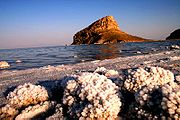
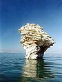
The lake is marked by more than a hundred small rocky islands, which are stopover points in the migrations of various kinds of wild bird life (including flamingo
s, pelican
s, spoonbill
s, ibis
es, stork
s, shelduck
s, avocet
s, stilt
s, and gull
s).
By virtue of its high levels of salinity
, the lake does not sustain any fish
species. Nonetheless, Lake Urmia is considered a significant natural habitats of Artemia, which serve as food source for the migratory birds such as flamingo
s. Most of the area of the lake is considered a national park
.
The lake is a major barrier between two of the most important cities in West Azerbaijan and East Azerbaijan provinces, Urmia
and Tabriz
. A project to build a highway across the lake was initiated in the 1970s but was abandoned after the Iranian Revolution
of 1979, having finished a 15 km causeway with an unbridged gap. The project was revived in the early 2000s, and was completed in November 2008 with the opening of a 1.5 km bridge across the remaining gap. The highly saline environment is already heavily rusting the steel on the bridge despite anti-corrosion treatment. Experts have warned that the construction of the bridge, together with a series of ecological factors, will eventually lead to the drying up of the lake, turning it into a salt marsh which will directly affect the climate of the region. Lake Urmia has been shrinking for a long time, with an annual evaporation rate of 0.6m to 1m (24 to 39 inches). Although measures are now being taken to reverse the trend the lake has shrunken by 60 percent and could disappear entirely. Lake Urmia is a UNESCO
Biosphere Reserve
and a Ramsar site.
investigation on long cores from Lake Urmia has revealed a nearly 200 kyr record of vegetation and lake level changes. The vegetation has changed from the Artemisia/grass steppes during the glacial/stadial
periods to oak-juniper steppe-forests during the interglacial
/interstadial periods. The lake seems to have had a complex hydrological history and its water levels have greatly fluctuated in the geological history. Very high lake levels have been suggested for some time intervals during the two last glacial periods as well as during both the Last Interglacial as well as the Holocene
. Lowest lake levels have occurred during the last glacial periods.
transcription of a list of their names, see this link. The second largest island, Shahi Island
, is the burial place of Hulagu Khan
, the grandson of Genghis Khan
and the sacker of Baghdad
.
Salt lake
A salt lake or saline lake is a landlocked body of water which has a concentration of salts and other dissolved minerals significantly higher than most lakes . In some cases, salt lakes have a higher concentration of salt than sea water, but such lakes would also be termed hypersaline lakes...
in northwestern Iran
Iran
Iran , officially the Islamic Republic of Iran , is a country in Southern and Western Asia. The name "Iran" has been in use natively since the Sassanian era and came into use internationally in 1935, before which the country was known to the Western world as Persia...
, near Iran's border with Turkey
Turkey
Turkey , known officially as the Republic of Turkey , is a Eurasian country located in Western Asia and in East Thrace in Southeastern Europe...
. The lake is between the Iranian provinces of East Azerbaijan and West Azerbaijan, west of the southern portion of the similarly shaped Caspian Sea
Caspian Sea
The Caspian Sea is the largest enclosed body of water on Earth by area, variously classed as the world's largest lake or a full-fledged sea. The sea has a surface area of and a volume of...
. It is the largest lake in the Middle East, and the third largest salt water lake on earth, with a surface area of approximately 5,200 km² (2,000 mile²), 140 km (87 mi) length, 55 km (34.2 mi) width, and 16 m (52 ft) depth.
History
One of the early mentions of Lake Urmia is from the Assyrian records from 9th century BCE. Here from the records of Shalmaneser IIIShalmaneser III
Shalmaneser III was king of Assyria , and son of the previous ruler, Ashurnasirpal II....
(reign 858-824 BCE) two names (place or tribe name) of Parsuwash and Matai are mentioned in the area of Lake Urmia. It is not completely clear what are the identities of these names and subsequent personal names and "kings". But Matai's are Iranian Median and linguistically the name "Parsuwash" matches perfectly with the Old Persian pārsa- an Achaemenid well-known ethno-linguistic designation. Based on certain historical outline of how and when the Iranian people immigrated to the Iranian Plateau
Iranian plateau
The Iranian plateau, or Iranic plateau, is a geological formation in Southwest Asia. It is the part of the Eurasian Plate wedged between the Arabian and Indian plates, situated between the Zagros mountains to the west, the Caspian Sea and the Kopet Dag to the north, the Hormuz Strait and Persian...
in several waves along different routes, Old Persian language- the ancestor of Modern Persian was originally spoken by the people of/from "Parsuwash" who settled in Iranian Plateau sometime in early 1st millennium and finally moved down into an area where Achaemenid history began ca. 600 BCE.
The lake is named after the provincial capital city of Urmia
Urmia
- Demographics :According to official census of 2006, the population of Urmia is about 871,204.- Language :The population of Urmia is mainly Azerbaijani people, with Kurdish, Assyrian Christian, and Armenian minorities...
, originally a Syriac
Syriac language
Syriac is a dialect of Middle Aramaic that was once spoken across much of the Fertile Crescent. Having first appeared as a script in the 1st century AD after being spoken as an unwritten language for five centuries, Classical Syriac became a major literary language throughout the Middle East from...
name meaning city of water. It was called Lake Rezaiyeh in the early 1930s after Reza Shah Pahlavi, but the lake was renamed 'Urmia' in the late 1970s
Iranian Revolution
The Iranian Revolution refers to events involving the overthrow of Iran's monarchy under Shah Mohammad Reza Pahlavi and its replacement with an Islamic republic under Ayatollah Ruhollah Khomeini, the leader of the...
. Its ancient Persian name was Chichast (meaning, "glittering"--a reference to its glittering mineral particles suspended in the lake water and its shores). In the medieval times it came to be known as Lake Kabuda, or "azure," in Persian, (Gabod in Armenian).
Lake Matianus is an old name for Lake Urmia. It was the center of the Mannaean
Mannaeans
The Mannaeans were an ancient people who lived in the territory of present-day Iran and Azerbaijan, around the 10th to 7th centuries BC...
Kingdom, a potential Mannaean settlement represented by the ruin mound of Hasanlu was on the south side of Lake Matianus. Mannae was overrun by a people who were called Matiani or Matieni
Matiene
Matiene was the name of a kingdom in northwestern Iran which overran the kingdom of the Mannae. The Mannaeans were non-Indo-European, probably speaking either an Hurro-Urartian language like the Nairi or a Northeast Caucasian language like the Albanians to the north...
, an Iranic people variously identified as Scythian, Saka
Saka
The Saka were a Scythian tribe or group of tribes....
, Sarmatian, or Cimmerian. It is not clear whether the lake took its name from the people or the people from the lake, but the country came to be called Matiene
Matiene
Matiene was the name of a kingdom in northwestern Iran which overran the kingdom of the Mannae. The Mannaeans were non-Indo-European, probably speaking either an Hurro-Urartian language like the Nairi or a Northeast Caucasian language like the Albanians to the north...
or Matiane.
Chemistry
Sodium
Sodium is a chemical element with the symbol Na and atomic number 11. It is a soft, silvery-white, highly reactive metal and is a member of the alkali metals; its only stable isotope is 23Na. It is an abundant element that exists in numerous minerals, most commonly as sodium chloride...
ions are at slightly higher concentration in the south compared to the north of the lake, which could result from the shallower depth in the south, and a higher net evaporation rate.
The lake is divided into north and south parts separated by a causeway in which a 1500m gap provides little exchange of water between the two parts. Due to drought and increased demands for agricultural water in the lake's basin, the salinity of the lake has risen to more than 300 g/L during recent years, and large areas of the lake bed have been desiccated. As a result the fishery has been degraded.
Ecology
Lake Urmia (Orumieh in Persian), which lies in northwestern Iran, is home to some 212 species of birds, 41 reptiles, 7 amphibians, and 27 species of mammals, including the Iranian yellow deer.The construction of a dam on part of the lake and the recent drought has significantly decreased the annual amount of water Orumieh receives. This in turn has increased the salinity of Orumiyeh's water, causing the lake to lose its significance as home to thousands of migratory birds including the large flamingo populations.
The lake is marked by more than a hundred small rocky islands, which are stopover points in the migrations of various kinds of wild bird life (including flamingo
Flamingo
Flamingos or flamingoes are gregarious wading birds in the genus Phoenicopterus , the only genus in the family Phoenicopteridae...
s, pelican
Pelican
A pelican, derived from the Greek word πελεκυς pelekys is a large water bird with a large throat pouch, belonging to the bird family Pelecanidae....
s, spoonbill
Spoonbill
Spoonbills are a group of large, long-legged wading birds in the family Threskiornithidae, which also includes the Ibises.All have large, flat, spatulate bills and feed by wading through shallow water, sweeping the partly opened bill from side to side...
s, ibis
Ibis
The ibises are a group of long-legged wading birds in the family Threskiornithidae....
es, stork
Stork
Storks are large, long-legged, long-necked wading birds with long, stout bills. They belong to the family Ciconiidae. They are the only family in the biological order Ciconiiformes, which was once much larger and held a number of families....
s, shelduck
Shelduck
The shelducks, genus Tadorna, are a group of large birds in the Tadorninae subfamily of the Anatidae, the biological family that includes the ducks and most duck-like waterfowl such as the geese and swans....
s, avocet
Avocet
The four species of Avocets are a genus, Recurvirostra, of waders in the same avian family as the stilts.Avocets have long legs and long, thin, upcurved bills which they sweep from side to side when feeding in the brackish or saline wetlands they prefer...
s, stilt
Stilt
Stilt is a common name for several species of birds in the family Recurvirostridae, which also includes those known as avocets. They are found in brackish or saline wetlands in warm or hot climates....
s, and gull
Gull
Gulls are birds in the family Laridae. They are most closely related to the terns and only distantly related to auks, skimmers, and more distantly to the waders...
s).
By virtue of its high levels of salinity
Salinity
Salinity is the saltiness or dissolved salt content of a body of water. It is a general term used to describe the levels of different salts such as sodium chloride, magnesium and calcium sulfates, and bicarbonates...
, the lake does not sustain any fish
Fish
Fish are a paraphyletic group of organisms that consist of all gill-bearing aquatic vertebrate animals that lack limbs with digits. Included in this definition are the living hagfish, lampreys, and cartilaginous and bony fish, as well as various extinct related groups...
species. Nonetheless, Lake Urmia is considered a significant natural habitats of Artemia, which serve as food source for the migratory birds such as flamingo
Flamingo
Flamingos or flamingoes are gregarious wading birds in the genus Phoenicopterus , the only genus in the family Phoenicopteridae...
s. Most of the area of the lake is considered a national park
National park
A national park is a reserve of natural, semi-natural, or developed land that a sovereign state declares or owns. Although individual nations designate their own national parks differently A national park is a reserve of natural, semi-natural, or developed land that a sovereign state declares or...
.
The lake is a major barrier between two of the most important cities in West Azerbaijan and East Azerbaijan provinces, Urmia
Urmia
- Demographics :According to official census of 2006, the population of Urmia is about 871,204.- Language :The population of Urmia is mainly Azerbaijani people, with Kurdish, Assyrian Christian, and Armenian minorities...
and Tabriz
Tabriz
Tabriz is the fourth largest city and one of the historical capitals of Iran and the capital of East Azerbaijan Province. Situated at an altitude of 1,350 meters at the junction of the Quri River and Aji River, it was the second largest city in Iran until the late 1960s, one of its former...
. A project to build a highway across the lake was initiated in the 1970s but was abandoned after the Iranian Revolution
Iranian Revolution
The Iranian Revolution refers to events involving the overthrow of Iran's monarchy under Shah Mohammad Reza Pahlavi and its replacement with an Islamic republic under Ayatollah Ruhollah Khomeini, the leader of the...
of 1979, having finished a 15 km causeway with an unbridged gap. The project was revived in the early 2000s, and was completed in November 2008 with the opening of a 1.5 km bridge across the remaining gap. The highly saline environment is already heavily rusting the steel on the bridge despite anti-corrosion treatment. Experts have warned that the construction of the bridge, together with a series of ecological factors, will eventually lead to the drying up of the lake, turning it into a salt marsh which will directly affect the climate of the region. Lake Urmia has been shrinking for a long time, with an annual evaporation rate of 0.6m to 1m (24 to 39 inches). Although measures are now being taken to reverse the trend the lake has shrunken by 60 percent and could disappear entirely. Lake Urmia is a UNESCO
UNESCO
The United Nations Educational, Scientific and Cultural Organization is a specialized agency of the United Nations...
Biosphere Reserve
Biosphere reserve
The Man and the Biosphere Programme of UNESCO was established in 1971 to promote interdisciplinary approaches to management, research and education in ecosystem conservation and sustainable use of natural resources.-Development:...
and a Ramsar site.
Palaeoecology
A palynologicalPaleoecology
Paleoecology uses data from fossils and subfossils to reconstruct the ecosystems of the past. It involves the study of fossil organisms and their associated remains, including their life cycle, living interactions, natural environment, and manner of death and burial to reconstruct the...
investigation on long cores from Lake Urmia has revealed a nearly 200 kyr record of vegetation and lake level changes. The vegetation has changed from the Artemisia/grass steppes during the glacial/stadial
Stadial
A stadial is a period of lower temperatures during an interglacial separating the glacial periods of an ice age. Such periods are of insufficient duration or intensity to be considered glacial periods...
periods to oak-juniper steppe-forests during the interglacial
Interglacial
An Interglacial period is a geological interval of warmer global average temperature lasting thousands of years that separates consecutive glacial periods within an ice age...
/interstadial periods. The lake seems to have had a complex hydrological history and its water levels have greatly fluctuated in the geological history. Very high lake levels have been suggested for some time intervals during the two last glacial periods as well as during both the Last Interglacial as well as the Holocene
Holocene
The Holocene is a geological epoch which began at the end of the Pleistocene and continues to the present. The Holocene is part of the Quaternary period. Its name comes from the Greek words and , meaning "entirely recent"...
. Lowest lake levels have occurred during the last glacial periods.
Islands
Lake Urmia has 102 islands. For a PersianPersian language
Persian is an Iranian language within the Indo-Iranian branch of the Indo-European languages. It is primarily spoken in Iran, Afghanistan, Tajikistan and countries which historically came under Persian influence...
transcription of a list of their names, see this link. The second largest island, Shahi Island
Shahi Island
Shahi Island or King Island is the largest island in Urmia Lake, East Azerbaijan Province in Iran. King Island is 23,000 hectares and is located in eastern part of the lake. The island is the only residential island of the lake which has seven villages named Sarai, Aqgunbad, Gamichi, Burachlu,...
, is the burial place of Hulagu Khan
Hulagu Khan
Hulagu Khan, also known as Hülegü, Hulegu , was a Mongol ruler who conquered much of Southwest Asia...
, the grandson of Genghis Khan
Genghis Khan
Genghis Khan , born Temujin and occasionally known by his temple name Taizu , was the founder and Great Khan of the Mongol Empire, which became the largest contiguous empire in history after his death....
and the sacker of Baghdad
Baghdad
Baghdad is the capital of Iraq, as well as the coterminous Baghdad Governorate. The population of Baghdad in 2011 is approximately 7,216,040...
.
Basin rivers
- Aji ChayAji ChayAji Chay , or Talkheh-Rūd, is a river in north-western Iran. Most of it is situated in the East Azerbaijan Province.Its water is alkali due to passing from the lands with high mineralization. It is the largest river that discharges into Lake Urmia. It arises above Sarab from the slopes of Mount...
- Ghaie River
- Alamlou River
- Leylan River
- Zarrineh River
- Simineh River
- Gadar RiverGadar RiverThe Gadar River rises in the Iranian Zagros Mountains near the point where the borders of Iran, Turkey and Iraq meet. From its source, the river first flows towards the southeast and then changes course due east through the Ushnu-Solduz valley. After leaving the valley, the river turns north and...
- Mahabad River
- Barandouz River
- Shahar River
- Nazlou River
- Rozeh River
- Zola River
Protests for saving Lake Urmia
From March 2010, a series of serious protests and rallies demanding take action to save Lake Urmia was held in Iranian Azerbaijan:- On 2 April 2010 and 2011, and after several callings from Tractor Sazi F.C.'s fans in stadiums and internet sites, protest demanding that the government take action to save Lake Urmia was held in TabrizTabrizTabriz is the fourth largest city and one of the historical capitals of Iran and the capital of East Azerbaijan Province. Situated at an altitude of 1,350 meters at the junction of the Quri River and Aji River, it was the second largest city in Iran until the late 1960s, one of its former...
, UrmiaUrmia- Demographics :According to official census of 2006, the population of Urmia is about 871,204.- Language :The population of Urmia is mainly Azerbaijani people, with Kurdish, Assyrian Christian, and Armenian minorities...
, lake beach, and on top of the lake bridge. As a result, dozens of people were arrested by security forces.
- In August 2011, after the Iranian parliament dropped two emergency cases for reviving the lake, a number of soccer fans at TabrizTabrizTabriz is the fourth largest city and one of the historical capitals of Iran and the capital of East Azerbaijan Province. Situated at an altitude of 1,350 meters at the junction of the Quri River and Aji River, it was the second largest city in Iran until the late 1960s, one of its former...
derby (soccer match between Tractor Sazi F.C. and Shahrdari Tabriz F.C.Shahrdari Tabriz F.C.Shahrdari Tabriz Cultural and Athletic Club is an Iranian sports club most widely known for its professional football team based in Tabriz, Iran.They currently compete in the Iran Pro League, the first tier of Iranian football.-The birth of Shahrdari Tabriz F.C...
) were arrested for shouting slogans in favor of protecting the lake. Later that same week, Iranian Azerbaijanies scheduled a protest against the parliament move. Despite the capture of more than 20 activists by security forces the day before the protest, numerous people attended the event in Urmia cityUrmia- Demographics :According to official census of 2006, the population of Urmia is about 871,204.- Language :The population of Urmia is mainly Azerbaijani people, with Kurdish, Assyrian Christian, and Armenian minorities...
and a number of clashes with police were reported.
- On 3 September 2011, AzerbaijanisIranian AzerbaijanisIranian Azerbaijanis also known as Iranian Azeris, Iranian Turks, Azeri Turks or Persian Azerbaijanis, are Iranians of Azerbaijani ethnicity. Iranian Azeris are mainly found in the northwest provinces of East Azerbaijan, Ardabil, Zanjan, parts of West Azerbaijan, and in smaller numbers, in other...
demonstrated for second week in a row to protect Lake Urmia. The protests in TabrizTabrizTabriz is the fourth largest city and one of the historical capitals of Iran and the capital of East Azerbaijan Province. Situated at an altitude of 1,350 meters at the junction of the Quri River and Aji River, it was the second largest city in Iran until the late 1960s, one of its former...
and UrmiaUrmia- Demographics :According to official census of 2006, the population of Urmia is about 871,204.- Language :The population of Urmia is mainly Azerbaijani people, with Kurdish, Assyrian Christian, and Armenian minorities...
reportedly followed parliament’s rejection of rescue plan, and security forces used violence to break up environmental rallies as protesters demanded action to save lake Urmia , and according to West Azerbaijan's governor at least 60 supporters of the lake were arrested just in UrmiaUrmia- Demographics :According to official census of 2006, the population of Urmia is about 871,204.- Language :The population of Urmia is mainly Azerbaijani people, with Kurdish, Assyrian Christian, and Armenian minorities...
and dozens in TabrizTabrizTabriz is the fourth largest city and one of the historical capitals of Iran and the capital of East Azerbaijan Province. Situated at an altitude of 1,350 meters at the junction of the Quri River and Aji River, it was the second largest city in Iran until the late 1960s, one of its former...
because - according to an Iranian official - they had not applied for a permit to organize a demonstration. As the protests in Tabriz and other Iranian Azerbaijan cities, AzerisAzerbaijani peopleThe Azerbaijanis are a Turkic-speaking people living mainly in northwestern Iran and the Republic of Azerbaijan, as well as in the neighbourhood states, Georgia, Russia and formerly Armenia. Commonly referred to as Azeris or Azerbaijani Turks , they also live in a wider area from the Caucasus to...
resident in TurkeyTurkeyTurkey , known officially as the Republic of Turkey , is a Eurasian country located in Western Asia and in East Thrace in Southeastern Europe...
called for the preservation of saltwater Lake Urmia through a peaceful protest that included pouring salt and lying on the street in front of the Iranian Embassy in AnkaraAnkaraAnkara is the capital of Turkey and the country's second largest city after Istanbul. The city has a mean elevation of , and as of 2010 the metropolitan area in the entire Ankara Province had a population of 4.4 million....
.
External links
- Saline Systems; Urmia Salt Lake, Iran
- Profile at UNESCO Biosphere Reserve Directory
- Lake level fluctuations in the geological history
- Late Pleistocene vegetation changes in NW Iran
- Evaluation of dike-type causeway impacts on the flow and salinity regimes in Urmia Salt Lake, Iran
- Iran's Environmental Ticking Bomb
- www.urmiyalake.blogveb.com