
Black Rock Desert
Encyclopedia
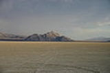
The Black Rock Desert is an arid region in the northern Nevada
section of the Great Basin
with a lakebed that is a dry remnant of Pleistocene
Lake Lahontan
. The region is notable for its paleogeologic features
, as an area of 19th-century Emigrant Trail
s to California
, as a venue for rocket
ry, and as an alternative to the Bonneville Salt Flats in northwestern Utah, for setting land speed record
s (Mach 1.02 in 1997
). It is also the location for the annual Burning Man
festival.
 The Black Rock Desert region is in northwestern Nevada
and the northwestern Great Basin
. The playa extends for approximately 100 mi (160.9 km) northeast from the towns of Gerlach and Empire
, between the Jackson Mountains
to the east and the Calico Mountains
to the west. The Black Rock Desert is separated into two arms by the Black Rock Range
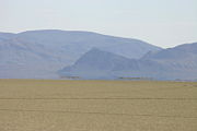
. It lies at an elevation of 3907 ft (1,190.9 m) and has an area of about 1000 sq mi (2,590 km²).
There are several possible definitions of the extent of the Black Rock Desert. Often people refer just to the playa surface. Sometimes terrain which can be seen from the playa is included. The widest definition of the Black Rock Desert region is the watershed of the basin that drains into the playa. The intermittent Quinn River
is the largest river in the region, starting in the Santa Rosa Range
and ending in the Quinn River Sink on the playa south of the Black Rock Range. The watershed covers 11600 sq mi (30,043.9 km²) including the Upper and Lower Quinn River
, Smoke Creek Desert
, Massacre Lake, and Thousand Creek/Virgin Valley watersheds of northwestern Nevada as well as small parts across the borders of California and Oregon.
Humboldt
, Pershing
and Washoe
Counties of Nevada intersect at the Black Rock Desert.
and which have dark Permian
volcanic rocks similar to another Permian black diabase
dike
formation in Nevada.
The portion of the Lake Lahontan
lakebed in the Black Rock Desert is generally flat with Lahontan salt shrub vegetation, widely-scattered hot spring
s, and a playa. In areas of the lakebed along mountains, rain shadow
results in desert precipitation levels.
The playa
of the Black Rock Desert lakebed is ~200 sq mi (518 km²) within an area bounded by the Calico Mountains Wilderness
(north), Gerlach (west), the Applegate National Historic Trail
(northeast), and the Union Pacific Railroad (south). The "South Playa
" (~30 sq mi, with ~13 sq mi (33.7 km²) in Washoe Co) is between Gerlach and the southwest boundary of the National Conservation Area
(NCA), while the northeast NCA portion of the playa (including ~25 sq mi (64.7 km²) in Humboldt Co) is between the NCA boundary and the Applegate National Historic Trail
. A Nobles route
between Gerlach and Black Rock Hot Springs extends through the length of the playa. The playa's Quinn River Sink of ~3 sq mi (7.8 km²) is where the Quinn River
discharges/evaporates ~2.75 miles (4.4 km) south-southwest of Black Rock Hot Springs.
mine and drywall
(brand named Sheetrock) manufacturing plant in Empire, which employed 107 people and produced 266,300 tons of gypsum in 2008.
Allied Nevada Gold Corporation re-opened the Hycroft Gold Mine in 2008 after acquiring it from Vista Gold Corp. Hycroft is a strip-mining operation in the Kamma Mountains
near Sulphur on the east side of the Black Rock Desert. An opal
mine is in the base of the Calico Mountains on the west side of the desert.
was found. Copies of the bones are now exhibited at the Nevada State Museum, Carson City
.
:
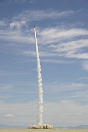
Other rocket launches attempting various altitude records or space flights have occurred at Black Rock. In May 1999, JP Aerospace
used a rockoon
(balloon-launched rocket) in an unsuccessful suborbital space flight
attempt covered by CNN
. The rocket reached 75000 feet (22,860 m), which was far less than the intended Karman Line to reach space. CSXT made unsuccessful space launch attempts in 2000 and 2002 before the successful 2004 space flight. JP Aerospace returned to the desert in 2009, launching an armchair to the edge of space for Space Chair
, an advertisement for Toshiba
electronic products.
 More than ~15,000 years ago (15 tya), the Humboldt River
flowed to the Smoke Creek-Black Rock Desert sub-basin, and during the recession of Lake Lahontan
, the river diverted to the Carson Desert sub-basin
. During the highest Lahontan water level (~12.7 tya), the lakebed was under about 500 ft (152.4 m) of water, under which sediment accumulated to form a flat lakebed.
Great Basin tribes
inhabited the area 7.0 tya, and a Frémont Expedition encountered the site in 1843, but the Fortieth Parallel Survey (1867) conducted the first official exploration. In the late 1840s, Peter Lassen
led California Trail
emigrants through the desert's Applegate-Lassen Cutoff, an arduous route that took them hundreds of miles away from the gold lands of California. By 1910, Western Pacific's
Feather River Route
(Oakland-Salt Lake City) had been completed across the east side of the lakebed on the "general route first explored by Lieutenant E.G. Beckwith in 1854". By 1927, the desert had been used for filming The Winning of Barbara Worth
(the 2003 Mythbusters pilot episode was also filmed in the area).
In World War II
, 973 sq mi (2,520.1 km²) of the Black Rock Desert was used for a USAAF aerial gunnery
training range, and post-war, the north region of the United States Navy
's Lovelock Aerial Gunnery Range
was in the Black Rock Desert area (the Black Rock Desert Gunnery Range had closed by 1964). In 1979, a fossilized Columbian Mammoth
was found along the side of the lakebed.
The first "Balls" rocket event was held at the desert in 1993, and in 1998, the first annual Gerlach Dash glider race
from Reno
to the desert was held. For its 30th anniversary, the Black Rock Press published a 1994 book of desert photographs. The Friends of the Black Rock/High Rock organized in 1999, and a National Conservation Area Act the next year created several protected areas of the desert. Also in 2000, Lisa O'Shea died 7 days after being scalded in Double Hot Springs when she attempted to rescue 2 dogs, and the Bureau of Land Management
subsequently fenced "Double Hot".
was fined $2.5 million in 2002 for archeological looting of Elephant Mountain Cave, and in 2008, an injured man was rescued when an aircraft pilot radioed for help after noticing him lying face-down on the lakebed. In 2010, the BLM's Winnemucca District Office completed a roundup of 1,922 wild horses
in the Calico Mountains Complex, of which 39 died of malnutrition due to overgrazing.
, near Interstate 80
. The desert's dirt roads are generally not usable in wet or snowy conditions. Old Highway 34
provides access to the playa on the west side and to the Hualapai Flat
. Old Highway 48
(dirt) connects the playa to Lovelock
, and Old Highway 49
(Jungo Road, dirt) provides access to the lakebed from the Sulphur and Jungo ghost towns.
The Feather River Route
uses the lakebed's east side between Sulphur and Gerlach. Light aircraft have landed on the lakebed for events (the nearby Empire
and Reno-Tahoe International Airports provide commercial service for the area
).
Nevada
Nevada is a state in the western, mountain west, and southwestern regions of the United States. With an area of and a population of about 2.7 million, it is the 7th-largest and 35th-most populous state. Over two-thirds of Nevada's people live in the Las Vegas metropolitan area, which contains its...
section of the Great Basin
Great Basin
The Great Basin is the largest area of contiguous endorheic watersheds in North America and is noted for its arid conditions and Basin and Range topography that varies from the North American low point at Badwater Basin to the highest point of the contiguous United States, less than away at the...
with a lakebed that is a dry remnant of Pleistocene
Pleistocene
The Pleistocene is the epoch from 2,588,000 to 11,700 years BP that spans the world's recent period of repeated glaciations. The name pleistocene is derived from the Greek and ....
Lake Lahontan
Lake Lahontan
Lake Lahontan was a large endorheic Pleistocene lake of modern northwestern Nevada that extended into northeastern California and southern Oregon...
. The region is notable for its paleogeologic features
Paleogeology
Paleogeology is the historical geological state of a particular area, or the study of the geologic history and origins of the earth, including such things as reconstructions of previous configurations of the Earth's continents, the history and evolution of the Earth's surface geological...
, as an area of 19th-century Emigrant Trail
Emigrant Trail
The Emigrant Trails were the northern networks of overland wagon trails throughout the American West, used by emigrants from the eastern United States to settle lands west of the Interior Plains during the overland migrations of the mid-19th century...
s to California
California Trail
The California Trail was an emigrant trail of about across the western half of the North American continent from Missouri River towns to what is now the state of California...
, as a venue for rocket
Rocket
A rocket is a missile, spacecraft, aircraft or other vehicle which obtains thrust from a rocket engine. In all rockets, the exhaust is formed entirely from propellants carried within the rocket before use. Rocket engines work by action and reaction...
ry, and as an alternative to the Bonneville Salt Flats in northwestern Utah, for setting land speed record
Land speed record
The land speed record is the highest speed achieved by a wheeled vehicle on land. There is no single body for validation and regulation; in practice the Category C flying start regulations are used, officiated by regional or national organizations under the auspices of the Fédération...
s (Mach 1.02 in 1997
ThrustSSC
ThrustSSC, also spelt Thrust SSC by secondary sources, is a British jet-propelled car developed by Richard Noble, Glynne Bowsher, Ron Ayers and Jeremy Bliss....
). It is also the location for the annual Burning Man
Burning Man
Burning Man is a week-long annual event held in the Black Rock Desert in northern Nevada, in the United States. The event starts on the Monday before the American Labor Day holiday, and ends on the holiday itself. It takes its name from the ritual burning of a large wooden effigy on Saturday evening...
festival.
Geography
Nevada
Nevada is a state in the western, mountain west, and southwestern regions of the United States. With an area of and a population of about 2.7 million, it is the 7th-largest and 35th-most populous state. Over two-thirds of Nevada's people live in the Las Vegas metropolitan area, which contains its...
and the northwestern Great Basin
Great Basin
The Great Basin is the largest area of contiguous endorheic watersheds in North America and is noted for its arid conditions and Basin and Range topography that varies from the North American low point at Badwater Basin to the highest point of the contiguous United States, less than away at the...
. The playa extends for approximately 100 mi (160.9 km) northeast from the towns of Gerlach and Empire
Gerlach-Empire, Nevada
Gerlach-Empire is a census-designated place in Washoe County, Nevada, United States. The combined population was 499 at the 2000 census. A former company town for United States Gypsum Corporation, Empire was once home to more than 750 people. It is part of the Reno–Sparks Metropolitan...
, between the Jackson Mountains
Jackson Mountains
One hundred seventy five million years ago continental plates collided causing the rise of the Jackson Mountain Range. Today the majority of the range is divided into two federally protected wilderness area, the North Jackson Wilderness and the South Jackson Wilderness...
to the east and the Calico Mountains
Calico Mountains (Nevada)
The Calico Mountains are a mountain range in northwestern Nevada. The range runs north to south along the western edge of the Black Rock Desert. This mountain range is located in western Humboldt and northern Pershing Counties, approximately 30 miles north of the town of Gerlach, Nevada...
to the west. The Black Rock Desert is separated into two arms by the Black Rock Range
Black Rock Range
The Black Rock Range is a mountain range in northwestern Nevada. It is named for Black Rock Point, which is located at the southern end of the range. The Black Rock Range divides the Black Rock Desert into eastern and western arms...
. It lies at an elevation of 3907 ft (1,190.9 m) and has an area of about 1000 sq mi (2,590 km²).
There are several possible definitions of the extent of the Black Rock Desert. Often people refer just to the playa surface. Sometimes terrain which can be seen from the playa is included. The widest definition of the Black Rock Desert region is the watershed of the basin that drains into the playa. The intermittent Quinn River
Quinn River
The Quinn River, once known as the Queen River, is an intermittent river, approximately long, in the desert of northwestern Nevada in the United States. It drains an enclosed basin inside the larger Great Basin....
is the largest river in the region, starting in the Santa Rosa Range
Santa Rosa Range
The Santa Rosa Range is a line of mountains in northern Nevada in the western United States. The range extends for approximately 75 miles north from the Humboldt River west of Winnemucca through eastern Humboldt County to the border with Oregon. The highest peaks in the range are Granite Peak ...
and ending in the Quinn River Sink on the playa south of the Black Rock Range. The watershed covers 11600 sq mi (30,043.9 km²) including the Upper and Lower Quinn River
Quinn River
The Quinn River, once known as the Queen River, is an intermittent river, approximately long, in the desert of northwestern Nevada in the United States. It drains an enclosed basin inside the larger Great Basin....
, Smoke Creek Desert
Smoke Creek Desert
The Smoke Creek Desert is an arid region of northwestern Nevada, USA that lies to the north of Pyramid Lake, west of the Fox Range and east of the Smoke Creek Mountains. The southern end of the desert lies on the Pyramid Lake Indian Reservation, and a rail line lies at the eastern edge...
, Massacre Lake, and Thousand Creek/Virgin Valley watersheds of northwestern Nevada as well as small parts across the borders of California and Oregon.
Humboldt
Humboldt County, Nevada
Humboldt County is a county located in the U.S. state of Nevada. As of 2007, the population was estimated to be 18,052. Its county seat is Winnemucca.The county was the site of an arrest in 2000 that led to the U.S. Supreme Court decision Hiibel v...
, Pershing
Pershing County, Nevada
Pershing County is a county located in the U.S. state of Nevada. As of the 2000 census, the population was 6,693. Its county seat is Lovelock. The county was named after army general John J. Pershing . It was formed from Humboldt County in 1919, and the last county to be established in...
and Washoe
Washoe County, Nevada
Washoe County is a county located in the U.S. state of Nevada. The population was 421,407 at the 2010 census. Its county seat is Reno. Washoe County includes the Reno-Sparks metropolitan area.-History:...
Counties of Nevada intersect at the Black Rock Desert.
Mountain ranges
The following mountain ranges are within or bordering the Black Rock Desert region.
|
Little High Rock Mountains The Little High Rock Mountains is a mountain range in Washoe County, Nevada.... Massacre Range The Massacre Range is a mountain range in Washoe County, Nevada. The range is partly within the High Rock Canyon Wilderness.... Montana Mountains The Montana Mountains are a mountain range in Humboldt County, Nevada.... Pine Forest Range The Pine Forest Range is a mountain range in Humboldt County, Nevada.... Poker Brown Mountains The Poker Brown Mountains are a mountain range in Pershing County, Nevada.... Santa Rosa Range The Santa Rosa Range is a line of mountains in northern Nevada in the western United States. The range extends for approximately 75 miles north from the Humboldt River west of Winnemucca through eastern Humboldt County to the border with Oregon. The highest peaks in the range are Granite Peak ... Selenite Range The Selenite Range is a mountain range in Pershing County, Nevada. To its southwest is the Fox Range. To its northwest is the Black Rock Desert playa.... Sentinel Hills The Sentinel Hills are a mountain range in Humboldt County, Nevada.... Seven Troughs Range The Seven Troughs Range is a mountain range in Pershing County, Nevada.... Sheephead Mountains The Sheephead Mountains are a mountain range in Pershing County, Nevada.... Smoke Creek Mountains The Smoke Creek Mountains is a mountain range in Washoe County, Nevada at the California border, west of the Smoke Creek Desert.... Yellow Hills The Yellow Hills are a mountain range in Washoe County, Nevada. They are located within the East Fork High Rock Canyon Wilderness.... |
Geologic features
The desert has numerous volcanic and geothermal features of the northwest Nevada volcanic region, including two Black Rock Points (west and east) at the southern end of the Black Rock RangeBlack Rock Range
The Black Rock Range is a mountain range in northwestern Nevada. It is named for Black Rock Point, which is located at the southern end of the range. The Black Rock Range divides the Black Rock Desert into eastern and western arms...
and which have dark Permian
Permian
The PermianThe term "Permian" was introduced into geology in 1841 by Sir Sir R. I. Murchison, president of the Geological Society of London, who identified typical strata in extensive Russian explorations undertaken with Edouard de Verneuil; Murchison asserted in 1841 that he named his "Permian...
volcanic rocks similar to another Permian black diabase
Diabase
Diabase or dolerite is a mafic, holocrystalline, subvolcanic rock equivalent to volcanic basalt or plutonic gabbro. In North American usage, the term diabase refers to the fresh rock, whilst elsewhere the term dolerite is used for the fresh rock and diabase refers to altered material...
dike
Dike (geology)
A dike or dyke in geology is a type of sheet intrusion referring to any geologic body that cuts discordantly across* planar wall rock structures, such as bedding or foliation...
formation in Nevada.
The portion of the Lake Lahontan
Lake Lahontan
Lake Lahontan was a large endorheic Pleistocene lake of modern northwestern Nevada that extended into northeastern California and southern Oregon...
lakebed in the Black Rock Desert is generally flat with Lahontan salt shrub vegetation, widely-scattered hot spring
Hot spring
A hot spring is a spring that is produced by the emergence of geothermally heated groundwater from the Earth's crust. There are geothermal hot springs in many locations all over the crust of the earth.-Definitions:...
s, and a playa. In areas of the lakebed along mountains, rain shadow
Rain shadow
A rain shadow is a dry area on the lee side of a mountainous area. The mountains block the passage of rain-producing weather systems, casting a "shadow" of dryness behind them. As shown by the diagram to the right, the warm moist air is "pulled" by the prevailing winds over a mountain...
results in desert precipitation levels.
The playa
Sink (geography)
A geographic sink is a depression within an endorheic basin where water collects with no visible outlet. Instead of discharging, the collected water is lost due to evaporation and/or penetration...
of the Black Rock Desert lakebed is ~200 sq mi (518 km²) within an area bounded by the Calico Mountains Wilderness
Calico Mountains Wilderness
Calico Mountains Wilderness is a U S Wilderness Area in Nevada under the Bureau of Land Management. It is located in the Calico Mountains.Rockhounding, hunting, and dayhiking are in the wilderness. Photography of geologic formations and spring wildflowers is a pastime of local visitors...
(north), Gerlach (west), the Applegate National Historic Trail
Applegate Trail
The Applegate Trail was a wilderness trail through today's U.S. states of Idaho, Nevada, California, and Oregon, and was originally intended as a less dangerous route to the Oregon Territory.-Background:...
(northeast), and the Union Pacific Railroad (south). The "South Playa
Sink (geography)
A geographic sink is a depression within an endorheic basin where water collects with no visible outlet. Instead of discharging, the collected water is lost due to evaporation and/or penetration...
" (~30 sq mi, with ~13 sq mi (33.7 km²) in Washoe Co) is between Gerlach and the southwest boundary of the National Conservation Area
Black Rock Desert-High Rock Canyon Emigrant Trails National Conservation Area
The Black Rock Desert – High Rock Canyon Emigrant Trails National Conservation Area is the federal land in northwestern Nevada, under the Bureau of Land Management-BLM management and protection, and the ten Wilderness Areas within it....
(NCA), while the northeast NCA portion of the playa (including ~25 sq mi (64.7 km²) in Humboldt Co) is between the NCA boundary and the Applegate National Historic Trail
Applegate Trail
The Applegate Trail was a wilderness trail through today's U.S. states of Idaho, Nevada, California, and Oregon, and was originally intended as a less dangerous route to the Oregon Territory.-Background:...
. A Nobles route
Nobles Emigrant Trail
The Nobles Emigrant Trail, also known as the Fort Kearney, South Pass and Honey Lake Wagon Road, is a trail in California that was used by emigrant parties from the east as a shortened route to northern California. It was pioneered in 1851 by William Nobes, who discovered an easy shortcut between...
between Gerlach and Black Rock Hot Springs extends through the length of the playa. The playa's Quinn River Sink of ~3 sq mi (7.8 km²) is where the Quinn River
Quinn River
The Quinn River, once known as the Queen River, is an intermittent river, approximately long, in the desert of northwestern Nevada in the United States. It drains an enclosed basin inside the larger Great Basin....
discharges/evaporates ~2.75 miles (4.4 km) south-southwest of Black Rock Hot Springs.
Mining
Prospecting and mining has occurred in the Black Rock region since the mid-19th century. US Gypsum Corporation operated a gypsumGypsum
Gypsum is a very soft sulfate mineral composed of calcium sulfate dihydrate, with the chemical formula CaSO4·2H2O. It is found in alabaster, a decorative stone used in Ancient Egypt. It is the second softest mineral on the Mohs Hardness Scale...
mine and drywall
Drywall
Drywall, also known as plasterboard, wallboard or gypsum board is a panel made of gypsum plaster pressed between two thick sheets of paper...
(brand named Sheetrock) manufacturing plant in Empire, which employed 107 people and produced 266,300 tons of gypsum in 2008.
Allied Nevada Gold Corporation re-opened the Hycroft Gold Mine in 2008 after acquiring it from Vista Gold Corp. Hycroft is a strip-mining operation in the Kamma Mountains
Kamma Mountains
The Kamma Mountains are a mountain range in Pershing County, Nevada. The ghost town and railroad siding at Sulphur, Nevada is on the west side of the Kamma Mountains at the eastern edge of the Black Rock Desert playa....
near Sulphur on the east side of the Black Rock Desert. An opal
Opal
Opal is an amorphous form of silica related to quartz, a mineraloid form, not a mineral. 3% to 21% of the total weight is water, but the content is usually between 6% to 10%. It is deposited at a relatively low temperature and may occur in the fissures of almost any kind of rock, being most...
mine is in the base of the Calico Mountains on the west side of the desert.
Paleontology
In 1979 a fossilized Columbian MammothColumbian Mammoth
The Columbian Mammoth is an extinct species of elephant of the Quaternary period that appeared in North America during the late Pleistocene. It is believed by some authorities to be the same species as its slightly larger cousin, M...
was found. Copies of the bones are now exhibited at the Nevada State Museum, Carson City
Nevada State Museum, Carson City
The Nevada State Museum in Carson City is one of 6 Nevada State Museums operated by the Nevada Department of Cultural Affairs. The primary building of the Museum is the former Carson City Mint...
.
Land speed records
The flatness of the Black Rock Desert's lakebed surface has led to the area's use as a proving ground for experimental land vehicles. It was the site of two successful attempts on the World Land Speed RecordLand speed record
The land speed record is the highest speed achieved by a wheeled vehicle on land. There is no single body for validation and regulation; in practice the Category C flying start regulations are used, officiated by regional or national organizations under the auspices of the Fédération...
:
- In 1983, Richard NobleRichard NobleRichard Noble, OBE was the holder of the land speed record between 1983 and 1997, and was the project director of ThrustSSC, the vehicle which holds the current land speed record, set at Black Rock Desert, Nevada in 1997....
drove the jet-powered Thrust2Thrust2Thrust2 is a British designed and built jet propelled car, which held the world land speed record from 4 October 1983 to 25 September 1997.The car was designed by John Ackroyd and driven by Richard Noble. On October 4, 1983 the car reached a top speed of and broke the record at . This was...
car to a new record of 633 mph (283 m/s). Noble also headed up the team that beat the Thrust 2 record. - In 1997, ThrustSSCThrustSSCThrustSSC, also spelt Thrust SSC by secondary sources, is a British jet-propelled car developed by Richard Noble, Glynne Bowsher, Ron Ayers and Jeremy Bliss....
became the world's first and only supersonic car, reaching 766 mph (342.4 m/s).
Rocketry records and attempts
In addition to the flat surface, distance from populated areas and uncontrolled airspace over the area also attract experimentation with rockets. The following are highlights of amateur rocketry records set at Black Rock:- On November 23, 1996, the Reaction Research SocietyReaction Research SocietyThe Reaction Research Society is the oldest continuously operating amateur experimental rocket group in the United States. Founded by George James on 6 January 1943, originally as the Southern California Rocket Society, the organization's name was changed to the Glendale Rocket Society two months...
launched a rocket to 50 miles (80.5 km) in altitude, a significant leap in amateur rocket altitude records at the time. - On May 17, 2004 the Civilian Space eXploration TeamCivilian Space eXploration TeamThe Civilian Space eXploration Team, known as CSXT, is a team of around 30 civilians interested in private spaceflight. The team was created by Ky Michaelson. It has conducted multiple rocket launches in an attempt to establish altitude records...
(CSXT) launched a rocket to 72 miles (115.9 km) in altitude, which was the first amateur rocket to exceed the 62.14 miles (100 km) Karman LineKarman lineThe Kármán line lies at an altitude of above the Earth's sea level, and is commonly used to define the boundary between the Earth's atmosphere and outer space...
required to claim a space flight.
Other rocket launches attempting various altitude records or space flights have occurred at Black Rock. In May 1999, JP Aerospace
JP Aerospace
JP Aerospace is a volunteer-based organization dedicated to achieving affordable access to space. They have been hired by the U.S. Air Force to provide concepts to allow rapid launch of battlefield communication and monitoring systems....
used a rockoon
Rockoon
A rockoon is a solid fuel sounding rocket that, rather than being immediately lit while on the ground, is first carried into the upper atmosphere by a gas-filled balloon, then separated from the balloon and automatically ignited...
(balloon-launched rocket) in an unsuccessful suborbital space flight
Sub-orbital spaceflight
A sub-orbital space flight is a spaceflight in which the spacecraft reaches space, but its trajectory intersects the atmosphere or surface of the gravitating body from which it was launched, so that it does not complete one orbital revolution....
attempt covered by CNN
CNN
Cable News Network is a U.S. cable news channel founded in 1980 by Ted Turner. Upon its launch, CNN was the first channel to provide 24-hour television news coverage, and the first all-news television channel in the United States...
. The rocket reached 75000 feet (22,860 m), which was far less than the intended Karman Line to reach space. CSXT made unsuccessful space launch attempts in 2000 and 2002 before the successful 2004 space flight. JP Aerospace returned to the desert in 2009, launching an armchair to the edge of space for Space Chair
Space Chair
Space Chair is a British television and cinema advertisement launched by Toshiba in 2009 to promote its Regza SD LCD televisions. The 60-second piece, following the launch of an armchair into near space attached to a weather balloon, is the second in the "Projects" campaign, following on from Time...
, an advertisement for Toshiba
Toshiba
is a multinational electronics and electrical equipment corporation headquartered in Tokyo, Japan. It is a diversified manufacturer and marketer of electrical products, spanning information & communications equipment and systems, Internet-based solutions and services, electronic components and...
electronic products.
History
Humboldt River
The Humboldt River runs through northern Nevada in the western United States. At approximately long it is the second longest river in the Great Basin, after the Bear River. It has no outlet to the ocean, but instead empties into the Humboldt Sink...
flowed to the Smoke Creek-Black Rock Desert sub-basin, and during the recession of Lake Lahontan
Lake Lahontan
Lake Lahontan was a large endorheic Pleistocene lake of modern northwestern Nevada that extended into northeastern California and southern Oregon...
, the river diverted to the Carson Desert sub-basin
Carson Sink
Carson Sink is a playa in the northeastern portion of the Carson Desert that was formerly the terminus of the Carson River. The sink is currently fed by drainage canals of the Truckee-Carson Irrigation District...
. During the highest Lahontan water level (~12.7 tya), the lakebed was under about 500 ft (152.4 m) of water, under which sediment accumulated to form a flat lakebed.
Great Basin tribes
Great Basin tribes
The Indigenous peoples of the Great Basin are the Native American peoples of the Great Basin inhabited a cultural region between the Rocky Mountains and the Sierra Nevada, in what is now Nevada, and parts of Oregon, California, Idaho, Wyoming, and Utah. There is very little precipitation in the...
inhabited the area 7.0 tya, and a Frémont Expedition encountered the site in 1843, but the Fortieth Parallel Survey (1867) conducted the first official exploration. In the late 1840s, Peter Lassen
Peter Lassen
Peter Lassen was a Danish-American blacksmith, rancher, prospector and Freemason.-Early life:Peter Lassen was born on October 31, 1800 in Farum, Denmark and immigrated to Boston, Massachusetts in 1830...
led California Trail
California Trail
The California Trail was an emigrant trail of about across the western half of the North American continent from Missouri River towns to what is now the state of California...
emigrants through the desert's Applegate-Lassen Cutoff, an arduous route that took them hundreds of miles away from the gold lands of California. By 1910, Western Pacific's
Western Pacific Railroad
The Western Pacific Railroad was a Class I railroad in the United States. It was formed in 1903 as an attempt to break the near-monopoly the Southern Pacific Railroad had on rail service into northern California...
Feather River Route
Feather River Route
The Feather River Route is a rail line that was built and operated by the Western Pacific Railroad. It was constructed between 1906 and 1909, and connects the cities of Oakland, California, and Salt Lake City, Utah...
(Oakland-Salt Lake City) had been completed across the east side of the lakebed on the "general route first explored by Lieutenant E.G. Beckwith in 1854". By 1927, the desert had been used for filming The Winning of Barbara Worth
The Winning of Barbara Worth
The Winning of Barbara Worth is a silent western film, released by United Artists in 1926, and starring Ronald Colman, Vilma Bánky, and Gary Cooper . The film is based on the novel of the same name by Harold Bell Wright and was filmed in the Black Rock Desert, Nevada...
(the 2003 Mythbusters pilot episode was also filmed in the area).
In World War II
World War II
World War II, or the Second World War , was a global conflict lasting from 1939 to 1945, involving most of the world's nations—including all of the great powers—eventually forming two opposing military alliances: the Allies and the Axis...
, 973 sq mi (2,520.1 km²) of the Black Rock Desert was used for a USAAF aerial gunnery
Air gunner
An air gunner a.k.a. aerial gunner is a member of an air force aircrew who operates flexible-mount or turret-mounted machine guns or autocannons in an aircraft...
training range, and post-war, the north region of the United States Navy
United States Navy
The United States Navy is the naval warfare service branch of the United States Armed Forces and one of the seven uniformed services of the United States. The U.S. Navy is the largest in the world; its battle fleet tonnage is greater than that of the next 13 largest navies combined. The U.S...
's Lovelock Aerial Gunnery Range
Lovelock, Nevada
Lovelock is a city in western Nevada that is the county seat of Pershing County, the location of a prison, and the namesake of the area's Cold War gunnery range...
was in the Black Rock Desert area (the Black Rock Desert Gunnery Range had closed by 1964). In 1979, a fossilized Columbian Mammoth
Columbian Mammoth
The Columbian Mammoth is an extinct species of elephant of the Quaternary period that appeared in North America during the late Pleistocene. It is believed by some authorities to be the same species as its slightly larger cousin, M...
was found along the side of the lakebed.
The first "Balls" rocket event was held at the desert in 1993, and in 1998, the first annual Gerlach Dash glider race
Gliding competitions
Some of the pilots in the sport of gliding take part in gliding competitions. These are usually racing competitions, but there are also aerobatic contests and on-line league tables.-History of competitions:...
from Reno
Reno, Nevada
Reno is the county seat of Washoe County, Nevada, United States. The city has a population of about 220,500 and is the most populous Nevada city outside of the Las Vegas metropolitan area...
to the desert was held. For its 30th anniversary, the Black Rock Press published a 1994 book of desert photographs. The Friends of the Black Rock/High Rock organized in 1999, and a National Conservation Area Act the next year created several protected areas of the desert. Also in 2000, Lisa O'Shea died 7 days after being scalded in Double Hot Springs when she attempted to rescue 2 dogs, and the Bureau of Land Management
Bureau of Land Management
The Bureau of Land Management is an agency within the United States Department of the Interior which administers America's public lands, totaling approximately , or one-eighth of the landmass of the country. The BLM also manages of subsurface mineral estate underlying federal, state and private...
subsequently fenced "Double Hot".
21st century
Jack Lee HarelsonJack Lee Harelson
Jack Lee Harelson is an American insurance agent, best known for desecrating and looting a Paiute Indian burial site in the Black Rock Desert of Nevada.-Biography:...
was fined $2.5 million in 2002 for archeological looting of Elephant Mountain Cave, and in 2008, an injured man was rescued when an aircraft pilot radioed for help after noticing him lying face-down on the lakebed. In 2010, the BLM's Winnemucca District Office completed a roundup of 1,922 wild horses
Feral horse
A feral horse is a free-roaming horse of domesticated ancestry. As such, a feral horse is not a wild animal in the sense of an animal without domesticated ancestors. However, some populations of feral horses are managed as wildlife, and these horses often are popularly called "wild" horses...
in the Calico Mountains Complex, of which 39 died of malnutrition due to overgrazing.
Transportation
Nevada State Route 447 is the area's main highway and connects Gerlach to SR 427 at Wadsworth, NevadaWadsworth, Nevada
Wadsworth is a census-designated place in Washoe County, Nevada, United States. The population was 881 at the 2000 census. It is part of the Reno–Sparks Metropolitan Statistical Area. The town was named for General James S. Wadsworth, a Civil War general killed at the battle of the...
, near Interstate 80
Interstate 80 in Nevada
In the U.S. state of Nevada, Interstate 80 traverses the northern portion of the state. The freeway serves the Reno-Sparks metropolitan area, and also goes through the towns of Fernley, Lovelock, Winnemucca, Battle Mountain, Elko, Wells and West Wendover on its way through the state.I-80 follows...
. The desert's dirt roads are generally not usable in wet or snowy conditions. Old Highway 34
Nevada State Route 34
Former SR 34 is a signed decommissioned State highway in Nevada from prior to the state's highway restructuring in 1978. Today a portion of former SR 34 is maintained by the Washoe County as a county highway with the not well known designation CR 34...
provides access to the playa on the west side and to the Hualapai Flat
Hualapai Flat
Hualapai Flat is a valley in northwestern Nevada located northwest of the Black Rock Desert. The two valleys are separated by the Calico Hills. The Granite Range marks the southern and western edges of Hualapai Flat. To the north the valley is constrained by the Granite Range and the Calico Mountains...
. Old Highway 48
Nevada State Route 48
State Route 48 is the previous designation for State Routes 399 and 854 from Interstate 80 at Lovelock northwest to near Eagle Picher Mine, then northwest along an unimproved road to meet former State Route 49 east of Gerlach....
(dirt) connects the playa to Lovelock
Lovelock, Nevada
Lovelock is a city in western Nevada that is the county seat of Pershing County, the location of a prison, and the namesake of the area's Cold War gunnery range...
, and Old Highway 49
Nevada State Route 49
State Route 49, also known as Jungo Road, is an unimproved road from State Route 447 near Gerlach east to Winnemucca via Sulphur and Jungo...
(Jungo Road, dirt) provides access to the lakebed from the Sulphur and Jungo ghost towns.
The Feather River Route
Feather River Route
The Feather River Route is a rail line that was built and operated by the Western Pacific Railroad. It was constructed between 1906 and 1909, and connects the cities of Oakland, California, and Salt Lake City, Utah...
uses the lakebed's east side between Sulphur and Gerlach. Light aircraft have landed on the lakebed for events (the nearby Empire
Empire Airport (Nevada)
Empire Airport is a public airport located on the west side of Empire, in Washoe County, Nevada, USA.- Facilities :Empire Airport covers and has two runways:* Runway 7/25: , Surface: Dirt* Runway 18/36: , Surface: Dirt...
and Reno-Tahoe International Airports provide commercial service for the area
Reno-Sparks metropolitan area
The Reno–Sparks Metropolitan Statistical Area, as defined by the United States Census Bureau, is an area consisting of two counties in western Nevada, anchored by the cities of Reno and Sparks...
).