
Mojave River
Encyclopedia
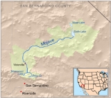
The Mojave River is an intermittent river
in the eastern San Bernardino Mountains
and Mojave Desert
in San Bernardino County, California
. The river is notable as most of its flow is underground, while its surface channels remain dry most of the time, with the exception of the headwaters and several bedrock gorges in the lower reaches.
, one of the Transverse Ranges
, above Hesperia
-San Bernardino
. The West Fork of the Mojave flows into Silverwood Lake
, formed by Cedar Springs Dam, which overflows in the Mojave River Forks Reserve area. On occasion, the lake releases water into the river. Downstream, Deep Creek meets the West Fork, forming the Mojave River immediately upstream of the Mojave River Dam, which provides flood control. Downstream of the dam, the Mojave River flows north and east, underground in most places, through Hesperia
, Victorville
, and Barstow
.
Near its terminus, the Mojave River flows out onto a large inland delta
called the Mojave River Wash at the western edge of Mojave National Preserve
. During heavy flows, the river reaches Soda Lake near Baker
at the north end of the Wash, and has reached Silver Lake
, even further north, in historic times. For example, during the unusually wet winter of 2004–2005, the Mojave River flowed on the surface all the way to Silver Lake and filled both Soda and Silver Lakes to a depth of several feet.
 The water in the river is mostly underground. The channel at the surface remains dry most of the time, but extreme flooding is possible. For example, during a heavy El Niño in the Mojave Desert
, rains caused the Mojave River to overflow onto overpassing bridges on 22 February 1993, the most damaged being on Bear Valley Road, where Victorville and Apple Valley
are separated. The water comes to the surface only in areas with impermeable rock, such as the upper and lower narrows near Victorville and in the Afton Canyon area northeast of Barstow.
Native Americans
called the Vanyume or Beñemé, as Father Garcés
called them, lived beyond and along much of the length of the Mojave River, from the east of Barstow to at least the Victorville region, and perhaps even farther upstream to the south, lived along the river for up to 8,000 years. The Indian trail, later the immigrants' Mojave Road
, paralleled the river from Soda Lake to the Cajon Pass
. Native American
s used this trade route where water could easily be found enroute to the coast. Garcés explored up the length of the Mojave River in early 1776. Jedediah Smith
was the first American to travel overland to California by following the Mojave Indian Trail in 1826.
Later, the Old Spanish Trail
and Salt Lake Trail (Mormon Trail
) joined up with the river and Mojave Road near the present-day location of Daggett
, where historic Camp Cady was located.
, is located 37 miles northeast of Barstow along Interstate 15
between the Afton Road and Basin Road exits. Afton Canyon is designated as an Area of Critical Environmental Concern to protect plant and wildlife habitat
, and to preserve scenic values of the Mojave River's riparian area within the canyon. The Rasor Off-Highway Vehicle Area
boundary enforcement has begun to reverse the heavy off-road vehicle
s use and damage that occurred in the riverbed and canyon. Restoration projects are ongoing, and have already brought the river's "proper functioning condition" from a "non-functioning" to a "functioning at risk" status. The objectives of the ambitious restoration project are to control exotic plants, particularly the phreatophyte Saltcedar - Tamarix
(primarily Tamarix ramosissima
and T. parviflora), and restoring critical desert California native plant
community "structural elements" for a functioning flora and fauna habitat.
----
River
A river is a natural watercourse, usually freshwater, flowing towards an ocean, a lake, a sea, or another river. In a few cases, a river simply flows into the ground or dries up completely before reaching another body of water. Small rivers may also be called by several other names, including...
in the eastern San Bernardino Mountains
San Bernardino Mountains
The San Bernardino Mountains are a short transverse mountain range north and east of San Bernardino in Southern California in the United States. The mountains run for approximately 60 miles east-west on the southern edge of the Mojave Desert in southwestern San Bernardino County, north of the...
and Mojave Desert
Mojave Desert
The Mojave Desert occupies a significant portion of southeastern California and smaller parts of central California, southern Nevada, southwestern Utah and northwestern Arizona, in the United States...
in San Bernardino County, California
San Bernardino County, California
San Bernardino County is a county in the U.S. state of California. As of the 2010 census, the population was 2,035,210, up from 1,709,434 as of the 2000 census...
. The river is notable as most of its flow is underground, while its surface channels remain dry most of the time, with the exception of the headwaters and several bedrock gorges in the lower reaches.
Course
The river's source is in the San Bernardino MountainsSan Bernardino Mountains
The San Bernardino Mountains are a short transverse mountain range north and east of San Bernardino in Southern California in the United States. The mountains run for approximately 60 miles east-west on the southern edge of the Mojave Desert in southwestern San Bernardino County, north of the...
, one of the Transverse Ranges
Transverse Ranges
The Transverse Ranges are a group of mountain ranges of southern California, in the Pacific Coast Ranges physiographic region that runs along the Pacific coast from Alaska to Mexico in North America. The Transverse Ranges begin at the southern end of the California Coast Ranges and lie between...
, above Hesperia
Hesperia, California
Hesperia is a city in San Bernardino County, California, United States. It is located in the Mojave Desert north of San Bernardino. The locals refer to the surrounding area as the High Desert...
-San Bernardino
San Bernardino
San Bernardino, California is a large city in the Inland Empire Metropolitan Area of Southern California.San Bernardino may also refer to:-Landforms:*San Bernardino , a torrent that flows through the Italian province of Verbano-Cusio-Ossola...
. The West Fork of the Mojave flows into Silverwood Lake
Silverwood Lake
Silverwood Lake is a large reservoir in San Bernardino County, California, United States, located on the west fork of the Mojave River in the San Bernardino Mountains...
, formed by Cedar Springs Dam, which overflows in the Mojave River Forks Reserve area. On occasion, the lake releases water into the river. Downstream, Deep Creek meets the West Fork, forming the Mojave River immediately upstream of the Mojave River Dam, which provides flood control. Downstream of the dam, the Mojave River flows north and east, underground in most places, through Hesperia
Hesperia, California
Hesperia is a city in San Bernardino County, California, United States. It is located in the Mojave Desert north of San Bernardino. The locals refer to the surrounding area as the High Desert...
, Victorville
Victorville, California
Victorville is a city located in the Victor Valley of southwestern San Bernardino County, California. According to the U.S. Census Bureau's 2010 census, the city had a population of 115,903, up from 64,030 at the 2000 census.-Geography and climate:...
, and Barstow
Barstow, California
Barstow is a city in San Bernardino County, California, United States. The population was 22,639 at the 2010 census, up from 21,119 at the 2000 census. Barstow is located north of San Bernardino....
.
Near its terminus, the Mojave River flows out onto a large inland delta
River delta
A delta is a landform that is formed at the mouth of a river where that river flows into an ocean, sea, estuary, lake, reservoir, flat arid area, or another river. Deltas are formed from the deposition of the sediment carried by the river as the flow leaves the mouth of the river...
called the Mojave River Wash at the western edge of Mojave National Preserve
Mojave National Preserve
Mojave National Preserve is located in the Mojave Desert of San Bernardino County, California, USA, between Interstate 15 and Interstate 40. The preserve was established October 31, 1994 with the passage of the California Desert Protection Act by the US Congress...
. During heavy flows, the river reaches Soda Lake near Baker
Baker, California
Baker is a census-designated place located in San Bernardino County, California, USA. As of the 2010 census, the town had a total population of 735.Baker was founded as a station on the Tonopah and Tidewater Railroad in 1908,...
at the north end of the Wash, and has reached Silver Lake
Silver Lake (Mojave)
Silver Lake is a dry lake bed in the Mojave Desert of San Bernardino County, California, along Interstate 15, northeast of Barstow.-History:...
, even further north, in historic times. For example, during the unusually wet winter of 2004–2005, the Mojave River flowed on the surface all the way to Silver Lake and filled both Soda and Silver Lakes to a depth of several feet.
Mojave Desert
The Mojave Desert occupies a significant portion of southeastern California and smaller parts of central California, southern Nevada, southwestern Utah and northwestern Arizona, in the United States...
, rains caused the Mojave River to overflow onto overpassing bridges on 22 February 1993, the most damaged being on Bear Valley Road, where Victorville and Apple Valley
Apple Valley, California
-Climate:*On average, the warmest month is July.*The highest recorded temperature was in 2002.*On average, the coolest month is December.*The lowest recorded temperature was in 1949.*The most precipitation on average occurs in February.-History:...
are separated. The water comes to the surface only in areas with impermeable rock, such as the upper and lower narrows near Victorville and in the Afton Canyon area northeast of Barstow.
History
A desert branch of the SerranoSerrano (people)
The Serrano are a Native American tribe of present day California, United States. They use the autonyms of Taaqtam, meaning "people"; Maarenga'yam, "people from Morongo"; and Yuhaviatam, "people of the pines." The Serrano historically populated the San Bernardino Mountains and extended east into...
Native Americans
Native Americans in the United States
Native Americans in the United States are the indigenous peoples in North America within the boundaries of the present-day continental United States, parts of Alaska, and the island state of Hawaii. They are composed of numerous, distinct tribes, states, and ethnic groups, many of which survive as...
called the Vanyume or Beñemé, as Father Garcés
Francisco Garcés
Francisco Hermenegildo Tomás Garcés was a Spanish Franciscan missionary who explored much of the southwestern part of North America, including what are now Arizona, southern California, and northeastern Baja California. Garcés was born April 12, 1738, in Morata de Jalón , Zaragoza province,...
called them, lived beyond and along much of the length of the Mojave River, from the east of Barstow to at least the Victorville region, and perhaps even farther upstream to the south, lived along the river for up to 8,000 years. The Indian trail, later the immigrants' Mojave Road
Mojave Road
The Mojave Road or Mojave Trail is a historic route and present day 'four-wheel drive road' across what is now the Mojave National Preserve in the Mojave Desert of California, United States.-History:...
, paralleled the river from Soda Lake to the Cajon Pass
Cajon Pass
Cajon Pass is a moderate-elevation mountain pass between the San Bernardino Mountains and the San Gabriel Mountains in Southern California in the United States. It was created by the movements of the San Andreas Fault...
. Native American
Native Americans in the United States
Native Americans in the United States are the indigenous peoples in North America within the boundaries of the present-day continental United States, parts of Alaska, and the island state of Hawaii. They are composed of numerous, distinct tribes, states, and ethnic groups, many of which survive as...
s used this trade route where water could easily be found enroute to the coast. Garcés explored up the length of the Mojave River in early 1776. Jedediah Smith
Jedediah Smith
Jedediah Strong Smith was a hunter, trapper, fur trader, trailblazer, author, cartographer, cattleman, and explorer of the Rocky Mountains, the American West Coast and the Southwest during the 19th century...
was the first American to travel overland to California by following the Mojave Indian Trail in 1826.
Later, the Old Spanish Trail
Old Spanish Trail (trade route)
The Old Spanish Trail is a historical trade route which connected the northern New Mexico settlements near or in Santa Fe, New Mexico with that of Los Angeles, California and southern California. Approximately long, it ran through areas of high mountains, arid deserts, and deep canyons. It is...
and Salt Lake Trail (Mormon Trail
Mormon Trail
The Mormon Trail or Mormon Pioneer Trail is the 1,300 mile route that members of The Church of Jesus Christ of Latter-day Saints traveled from 1846 to 1868...
) joined up with the river and Mojave Road near the present-day location of Daggett
Daggett, California
Daggett is an unincorporated town located in San Bernardino County, California in the United States. The town is located on Interstate 40 ten miles East of Barstow. The town has a population of about 200. The ZIP code is 92327 and the community is inside area code 760.-History:The town was...
, where historic Camp Cady was located.
Afton Canyon Natural Area
The Afton Canyon Natural Area, managed by the Bureau of Land ManagementBureau of Land Management
The Bureau of Land Management is an agency within the United States Department of the Interior which administers America's public lands, totaling approximately , or one-eighth of the landmass of the country. The BLM also manages of subsurface mineral estate underlying federal, state and private...
, is located 37 miles northeast of Barstow along Interstate 15
Interstate 15
Interstate 15 is the fourth-longest north–south Interstate Highway in the United States, traveling through the states of California, Nevada, Arizona, Utah, Idaho, and Montana from San Diego to the Canadian border...
between the Afton Road and Basin Road exits. Afton Canyon is designated as an Area of Critical Environmental Concern to protect plant and wildlife habitat
Habitat
* Habitat , a place where a species lives and grows*Human habitat, a place where humans live, work or play** Space habitat, a space station intended as a permanent settlement...
, and to preserve scenic values of the Mojave River's riparian area within the canyon. The Rasor Off-Highway Vehicle Area
Rasor Off-Highway Vehicle Area
Rasor Off-Highway Vehicle Area is a remote public use area for the off-highway vehicle user located in the Mojave Desert about east of Barstow, California, administered by the Bureau of Land Management....
boundary enforcement has begun to reverse the heavy off-road vehicle
Off-road vehicle
An off-road vehicle is considered to be any type of vehicle which is capable of driving on and off paved or gravel surface. It is generally characterized by having large tires with deep, open treads, a flexible suspension, or even caterpillar tracks...
s use and damage that occurred in the riverbed and canyon. Restoration projects are ongoing, and have already brought the river's "proper functioning condition" from a "non-functioning" to a "functioning at risk" status. The objectives of the ambitious restoration project are to control exotic plants, particularly the phreatophyte Saltcedar - Tamarix
Tamarix
The genus Tamarix is composed of about 50-60 species of flowering plants in the family Tamaricaceae, native to drier areas of Eurasia and Africa...
(primarily Tamarix ramosissima
Tamarix ramosissima
Tamarix ramosissima, commonly known as Saltcedar, is a deciduous arching shrub with reddish stems and feathery, pale green foliage.-Description:...
and T. parviflora), and restoring critical desert California native plant
California native plants
California native plants are plants that existed in California prior to the arrival of European explorers and colonists in the late 18th century...
community "structural elements" for a functioning flora and fauna habitat.
See also
- Category: Flora of the California desert regions
- Mojave National PreserveMojave National PreserveMojave National Preserve is located in the Mojave Desert of San Bernardino County, California, USA, between Interstate 15 and Interstate 40. The preserve was established October 31, 1994 with the passage of the California Desert Protection Act by the US Congress...
- Category: Protected areas of the Mojave Desert
External links
- Mojave River - Digital Desert
- The Mojave River and Associated Lakes
- Mojave River through the Victorville Narrows
- Official Afton Canyon Natural Area website
- Official Mojave National Preserve website
----