
Kunlun Mountains
Encyclopedia
Asia
Asia is the world's largest and most populous continent, located primarily in the eastern and northern hemispheres. It covers 8.7% of the Earth's total surface area and with approximately 3.879 billion people, it hosts 60% of the world's current human population...
, extending more than 3,000 km. In the broadest sense, it forms the northern edge of the Tibetan Plateau
Tibetan Plateau
The Tibetan Plateau , also known as the Qinghai–Tibetan Plateau is a vast, elevated plateau in Central Asia covering most of the Tibet Autonomous Region and Qinghai, in addition to smaller portions of western Sichuan, southwestern Gansu, and northern Yunnan in Western China and Ladakh in...
south of the Tarim Basin
Tarim Basin
The Tarim Basin is a large endorheic basin occupying an area of about . It is located in the Xinjiang Uyghur Autonomous Region in China's far west. Its northern boundary is the Tian Shan mountain range and its southern is the Kunlun Mountains on the northern edge of the Tibetan Plateau. The...
and the Gansu Corridor and continues east south of the Wei River
Wei River
The Wei River is a major river in west-central China's Gansu and Shaanxi provinces. It is the largest tributary of the Yellow River and very important in the early development of Chinese civilization....
to end at the North China Plain
North China Plain
The North China Plain is based on the deposits of the Yellow River and is the largest alluvial plain of eastern Asia. The plain is bordered on the north by the Yanshan Mountains and on the west by the Taihang Mountains edge of the Shanxi plateau. To the south, it merges into the Yangtze Plain...
.
The exact definition of this range seems to vary. An old source uses Kunlun to mean the mountain belt that runs across the center of China, that is, Kunlun in the narrow sense, Altyn Tagh, Qilian Mountains and Qin Mountains. A recent source has the Kunlun forming most of the south side of the Tarim Basin
Tarim Basin
The Tarim Basin is a large endorheic basin occupying an area of about . It is located in the Xinjiang Uyghur Autonomous Region in China's far west. Its northern boundary is the Tian Shan mountain range and its southern is the Kunlun Mountains on the northern edge of the Tibetan Plateau. The...
and then continuing east south of the Altyn Tagh. Sima Qian
Sima Qian
Sima Qian was a Prefect of the Grand Scribes of the Han Dynasty. He is regarded as the father of Chinese historiography for his highly praised work, Records of the Grand Historian , a "Jizhuanti"-style general history of China, covering more than two thousand years from the Yellow Emperor to...
(Shiji
Records of the Grand Historian
The Records of the Grand Historian, also known in English by the Chinese name Shiji , written from 109 BC to 91 BC, was the Magnum opus of Sima Qian, in which he recounted Chinese history from the time of the Yellow Emperor until his own time...
, scroll 123) says that Emperor Wu of Han
Emperor Wu of Han
Emperor Wu of Han , , personal name Liu Che , was the seventh emperor of the Han Dynasty of China, ruling from 141 BC to 87 BC. Emperor Wu is best remembered for the vast territorial expansion that occurred under his reign, as well as the strong and centralized Confucian state he organized...
sent men to find the source of the Yellow River and gave the name Kunlun to the mountains at its source. The name seems to have originated as a semi-mythical location in the Shan Hai Jing
Shan Hai Jing
Shan Hai Jing is a Chinese classic text, and a compilation of early geography and myth. Versions of the text have existed since the 4th century BC, and by the early Han Dynasty it had reached its final form. It is largely a fabled geographical and cultural account of pre-Qin China as well as a...
.
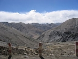
Extent
From the Pamirs of TajikistanTajikistan
Tajikistan , officially the Republic of Tajikistan , is a mountainous landlocked country in Central Asia. Afghanistan borders it to the south, Uzbekistan to the west, Kyrgyzstan to the north, and China to the east....
, it runs east along the border between Xinjiang
Xinjiang
Xinjiang is an autonomous region of the People's Republic of China. It is the largest Chinese administrative division and spans over 1.6 million km2...
and Tibet autonomous regions to the Sino-Tibetan ranges in Qinghai
Qinghai
Qinghai ; Oirat Mongolian: ; ; Salar:) is a province of the People's Republic of China, named after Qinghai Lake...
province. It stretches along the southern edge of what is now called the Tarim Basin
Tarim Basin
The Tarim Basin is a large endorheic basin occupying an area of about . It is located in the Xinjiang Uyghur Autonomous Region in China's far west. Its northern boundary is the Tian Shan mountain range and its southern is the Kunlun Mountains on the northern edge of the Tibetan Plateau. The...
, the infamous Takla Makan or "sand-buried houses" desert, and the Gobi Desert
Gobi Desert
The Gobi is a large desert region in Asia. It covers parts of northern and northwestern China, and of southern Mongolia. The desert basins of the Gobi are bounded by the Altai Mountains and the grasslands and steppes of Mongolia on the north, by the Hexi Corridor and Tibetan Plateau to the...
. A number of important rivers flow from it including the Karakash River
Karakash River
The Karakash or Black Jade River, also spelled Karakax , is a river in the Xinjiang autonomous region of the People's Republic of China, which lies partially in the disputed Aksai Chin region. The river originates near Sumde on the northern slopes of the Karakoram range in the Aksai Chin region of...
('Black Jade River') and the Yurungkash River ('White Jade River'), which flow through the Khotan
Khotan
Hotan , or Hetian , also spelled Khotan, is the seat of the Hotan Prefecture in Xinjiang, China. It was previously known in Chinese as 于窴/於窴 and to 19th-century European explorers as Ilchi....
Oasis
Oasis
In geography, an oasis or cienega is an isolated area of vegetation in a desert, typically surrounding a spring or similar water source...
into the Taklamakan Desert.
Altyn-Tagh
Altyn-Tagh
Altyn-Tagh, Astyn-Tagh, Altun Mountains, Altun Shan or Aerjin Shan Tagh proper is a part of the range south of Lop Nor), is a mountain range in northwestern China that separates the eastern Tarim Basin from the Tibetan Plateau...
or Altun Range is one of the chief northern ranges of the Kunlun. Nan Shan or its eastern extension Qilian is another main northern range of the Kunlun. In the south main extension is the Min Shan. Bayan Har Mountains
Bayan Har Mountains
The Bayan Har mountains are a mountain range in south-central part of Qinghai Province and the northwestern part of Sichuan Province in the People's Republic of China. It can be viewed as one of the branches of the Kunlun Mountains...
, a southern branch of the Kunlun Mountains, forms the watershed
Water divide
A drainage divide, water divide, divide or watershed is the line separating neighbouring drainage basins...
between the catchment basins of China
China
Chinese civilization may refer to:* China for more general discussion of the country.* Chinese culture* Greater China, the transnational community of ethnic Chinese.* History of China* Sinosphere, the area historically affected by Chinese culture...
's two longest rivers, the Yangtze River
Yangtze River
The Yangtze, Yangzi or Cháng Jiāng is the longest river in Asia, and the third-longest in the world. It flows for from the glaciers on the Tibetan Plateau in Qinghai eastward across southwest, central and eastern China before emptying into the East China Sea at Shanghai. It is also one of the...
and the Huang He.
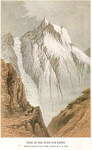
The highest mountain of the Kunlun Shan is the Kunlun Goddess
Liushi Shan
Liushi Shan, also commonly called Kunlun Goddess, is a mountain in the Kunlun Mountain Range in China. The mountain is located on the border of the Tibet and Xinjiang provinces of China....
(7,167 m) in the Keriya area. The Arka Tagh (Arch Mountain) is in the center of the Kunlun Shan; its highest point is Ulugh Muztagh
Ulugh Muztagh
Ulugh Muztagh or Ulugh Muztag and Muztag Feng , is an extremely remote mountain group on the northern Qinghai-Tibetan Plateau. Located on the border between the Tibetan Autonomous Region and Xinjiang Uyghur Autonomous Region, it is part of the main range of the Kunlun Mountains of East-Central...
. Some authorities claim that the Kunlun extends north westwards as far as Kongur Tagh
Kongur Tagh
Kongur Tagh or Kongkoerh is at 7,649 m the highest mountain wholly within the Xinjiang Uyghur Autonomous Region.-Geography:...
(7,649 m) and the famous Muztagh Ata
Muztagh Ata
Muztagh Ata, or Muztagata , is the second highest of the mountains which form the northern edge of the Tibetan Plateau . It is sometimes regarded as being part of the Kunlun Shan, although physically it is more closely connected to the Pamirs...
(7,546 m). But these mountains are physically much more closely linked to the Pamir
Pamir Mountains
The Pamir Mountains are a mountain range in Central Asia formed by the junction or knot of the Himalayas, Tian Shan, Karakoram, Kunlun, and Hindu Kush ranges. They are among the world’s highest mountains and since Victorian times they have been known as the "Roof of the World" a probable...
group (ancient Mount Imeon
Mount Imeon
Mount Imeon is an ancient name for the Central Asian complex of mountain ranges comprising the present Hindu Kush, Pamir and Tian Shan, extending from the Zagros Mountains in the southwest to the Altay Mountains in the northeast, and linked to the Kunlun, Karakoram and Himalayas to the southeast...
).
The mountain range formed at the northern edges of the Cimmerian Plate
Cimmerian Plate
The Cimmerian Plate is an ancient tectonic plate that comprises parts of present-day Anatolia, Iran, Afghanistan, Tibet, Indochina and Malaya regions. The Cimmerian Plate was formerly part of the ancient supercontinent of Pangaea. Pangaea was shaped like a vast "C", facing east, and inside of the...
during its collision, in the Late
Late Triassic
The Late Triassic is in the geologic timescale the third and final of three epochs of the Triassic period. The corresponding series is known as the Upper Triassic. In the past it was sometimes called the Keuper, after a German lithostratigraphic group that has a roughly corresponding age...
Triassic
Triassic
The Triassic is a geologic period and system that extends from about 250 to 200 Mya . As the first period of the Mesozoic Era, the Triassic follows the Permian and is followed by the Jurassic. Both the start and end of the Triassic are marked by major extinction events...
, with Siberia
Siberia (continent)
Siberia is the craton located in the heart of the region of Siberia. Siberia or "Angaraland" is today the Central Siberian Plateau...
, which resulted in the closing of the Paleo-Tethys Ocean
Paleo-Tethys Ocean
The Paleo-Tethys Ocean was an ancient Paleozoic ocean. It was located between the paleocontinent Gondwana and the so called Hunic terranes. These are divided into the European Hunic and Asiatic Hunic...
.
The range has very few roads and in its 3,000 km length is crossed by only two. In the west, Highway 219
China National Highway 219
China National Highway 219 runs along the southwestern border of the People's Republic of China, from Kargilik in the Xinjiang Uyghur Autonomous Region to Lhazê in the Tibet Autonomous Region. It is 2,743 kilometres in length. Construction of this road was started in 1951. It was completed in 1957...
traverses the range en route from Yecheng, Xinjiang to Lhatse, Tibet. Further east, Highway 109 crosses between Lhasa
Lhasa
Lhasa is the administrative capital of the Tibet Autonomous Region in the People's Republic of China and the second most populous city on the Tibetan Plateau, after Xining. At an altitude of , Lhasa is one of the highest cities in the world...
and Golmud
Golmud
Golmud , sometimes transliterated as Ge'ermu or Geermu, is a county-level city in Qinghai Province, Western China. Administrated by Haixi Mongol and Tibetan Autonomous Prefecture, it is the second largest city in Qinghai and the third largest in the Tibetan Plateau . The population is now about...
.
Kunlun Volcanoes
One of over 70 Kunlun Volcanoes is the highest volcano in Asia and China and second in East Hemisphere (after Mount KilimanjaroMount Kilimanjaro
Kilimanjaro, with its three volcanic cones, Kibo, Mawenzi, and Shira, is a dormant volcano in Kilimanjaro National Park, Tanzania and the highest mountain in Africa at above sea level .-Geology:...
) and one of Volcanic Seven Summits
Volcanic Seven Summits
The Volcanic Seven Summits are the highest volcanoes on each of the seven continents, just as the Seven Summits are the highest peaks on each of the seven continents...
by elevation, with 5808 metres (19,055 ft) above sea level (35.5°N 80.2°E), the last known eruption is on May 27, 1951.
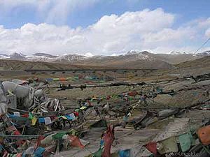
Mythology
The Kunlun mountains are believed to be the paradiseParadise
Paradise is a place in which existence is positive, harmonious and timeless. It is conceptually a counter-image of the miseries of human civilization, and in paradise there is only peace, prosperity, and happiness. Paradise is a place of contentment, but it is not necessarily a land of luxury and...
of Taoism
Taoism
Taoism refers to a philosophical or religious tradition in which the basic concept is to establish harmony with the Tao , which is the mechanism of everything that exists...
. The first to visit this paradise was, according to the legends, King Mu
King Mu of Zhou
King Mu of Zhou or King Mu of Chou or Mu Wang or Mu Wang was the fifth sovereign of the Chinese Zhou Dynasty. The dates of his reign are 976-922 BC or 956-918 BC.-Life:...
(976-922 BCE) of the Zhou Dynasty
Zhou Dynasty
The Zhou Dynasty was a Chinese dynasty that followed the Shang Dynasty and preceded the Qin Dynasty. Although the Zhou Dynasty lasted longer than any other dynasty in Chinese history, the actual political and military control of China by the Ji family lasted only until 771 BC, a period known as...
. He supposedly discovered there the Jade Palace of Huang-Di, the mythical Yellow Emperor
Yellow Emperor
The Yellow Emperor or Huangdi1 is a legendary Chinese sovereign and culture hero, included among the Three Sovereigns and Five Emperors. Tradition holds that he reigned from 2697–2597 or 2696–2598 BC...
and originator of Chinese culture, and met Hsi Wang Mu (Xi Wang Mu) , the 'Spirit Mother of the West' usually called the 'Queen Mother of the West', who was the object of an ancient religious cult which reached its peak in the Han Dynasty
Han Dynasty
The Han Dynasty was the second imperial dynasty of China, preceded by the Qin Dynasty and succeeded by the Three Kingdoms . It was founded by the rebel leader Liu Bang, known posthumously as Emperor Gaozu of Han. It was briefly interrupted by the Xin Dynasty of the former regent Wang Mang...
, also had her mythical abode in these mountains.
Kunlun martial arts
The Kunlun mountains are associated with a number of different martial arts, and are considered by some as an alternate source for the Daoist martial arts (Wudang being traditionally claimed as the source.)Some styles associated with the Kunlun mountains:
Kunlun Mountain Fist
Kunlun Mountain Fist
The history of this style is unclear, but there are two likely sources for this style:#The name Kunlun Mountain Fist may be a reference to the Kunlun mountain range, which is associated with Daoism....
is a style associated with the Kunlun mountain range, although similarities between this style and Kunlunquan
Kunlunquan
Kunlunquan is a style of Chinese martial arts popular in the province of Guangdong. As it is practiced by the minority Hakka it is considered a Kejiaquan. It was officially included among the styles nanquan, but originated in northern China. It was handed down in 1880 by Huang Huilong or feilong...
, as well as the name of one of the forms (White Cloud Mountain Fist) suggest that this style may be associated with Kunlun Mountain in Shandong
Shandong
' is a Province located on the eastern coast of the People's Republic of China. Shandong has played a major role in Chinese history from the beginning of Chinese civilization along the lower reaches of the Yellow River and served as a pivotal cultural and religious site for Taoism, Chinese...
province
Kunlunquan
Kunlunquan
Kunlunquan is a style of Chinese martial arts popular in the province of Guangdong. As it is practiced by the minority Hakka it is considered a Kejiaquan. It was officially included among the styles nanquan, but originated in northern China. It was handed down in 1880 by Huang Huilong or feilong...
may be named after the Kunlun mountain range, or it may be named after Kunlun Mountain in Shandong
Shandong
' is a Province located on the eastern coast of the People's Republic of China. Shandong has played a major role in Chinese history from the beginning of Chinese civilization along the lower reaches of the Yellow River and served as a pivotal cultural and religious site for Taoism, Chinese...
province.