
.gif)
Goose Lake (Oregon-California)
Encyclopedia
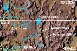
Goose Lake is a large alkali
ne glacial lake
located in the Goose Lake Valley
on the Oregon
-California
border. The north end of the lake is in Lake County, Oregon
and the south end is in Modoc County, California
. The mountains at the north end of the lake are part of the Fremont National Forest
and the south end of the lake is adjacent to Modoc National Forest
lands. Most of the valley property around the lake is privately owned agricultural land, though Goose Lake State Recreation Area
is on the Oregon side of the lake.
Goose Lake is the center of is a semi-closed drainage basin
. Its watershed is normally endorheic, but sometimes flows into the Pit River
, part of the Sacramento River
watershed. During the 1970s and 1980s the USGS
defined Goose Lake as part of the Sacramento's watershed, but has redefined Goose Lake's watershed as a closed basin.
 Goose Lake is part of a geological trough
which runs from Oregon southward past Death Valley
, the Walker Lane
.
Goose Lake attracts wildlife watchers, campers, and boaters. It is habitat to many flora and fauna including Western Grebe
, Long-billed Curlew
, and a large herd of mule deer
which spend much of the time in the 48-site campground.
The park provides hot showers, grassy areas suitable for tents, paved sites, shade trees, fireplaces, electrical hookups, telephone, and a dump station. The campground is open mid-April to mid-October.
Recreational activities on or around the lake include kayaking, canoeing, and hunting, but not fishing. When the lake is full, it has a maximum depth of 24 feet (7.3 m).
The lake is located near the historic Fandango Pass
route used to enter California by 19th century settlers. In the mid-19th century, particularly during the California Gold Rush
, the Applegate-Lassen Cut-Off of the California Trail
left the main route of that Trail near present-day Rye Patch Reservoir, and crossed the Black Rock Desert
, on the way to Goose Lake and the California gold fields. The Lassen Cut-Off continued down the Pit River
into California's Central Valley, while the Applegate Cut-Off went into southern Oregon along the Lost River
.
The lake completely dried up in the years 1851, 1852, 1926, 1929–1934, and 1992. Formerly, Goose Lake was the regular source of the Pit River, which flows into California's Sacramento River
, but water diversion has caused the lake level to drop below its outlet. The Pit River's source is now south of Goose Lake and the lake's salinity is increasing, threatening fish populations. During rare high water levels, Goose Lake still spills into the Pit River.
Alkali
In chemistry, an alkali is a basic, ionic salt of an alkali metal or alkaline earth metal element. Some authors also define an alkali as a base that dissolves in water. A solution of a soluble base has a pH greater than 7. The adjective alkaline is commonly used in English as a synonym for base,...
ne glacial lake
Glacial lake
A glacial lake is a lake with origins in a melted glacier. Near the end of the last glacial period, roughly 10,000 years ago, glaciers began to retreat. A retreating glacier often left behind large deposits of ice in hollows between drumlins or hills. As the ice age ended, these melted to create...
located in the Goose Lake Valley
Goose Lake Valley
The Goose Lake Valley is located in south-central Oregon and northeastern California, United States. It is a high valley at the northwestern corner of North America’s basin and range province. Much of the valley floor is covered by Goose Lake, a large endorheic lake that straddles the...
on the Oregon
Oregon
Oregon is a state in the Pacific Northwest region of the United States. It is located on the Pacific coast, with Washington to the north, California to the south, Nevada on the southeast and Idaho to the east. The Columbia and Snake rivers delineate much of Oregon's northern and eastern...
-California
California
California is a state located on the West Coast of the United States. It is by far the most populous U.S. state, and the third-largest by land area...
border. The north end of the lake is in Lake County, Oregon
Lake County, Oregon
Lake County is a county in the high desert south central region of the U.S. state of Oregon, so named for the many lakes found within its boundaries, including Lake Abert, Hart Lake Reservoir, and Goose Lake. While Lake is among Oregon's largest counties, it is sparsely populated with 7,895...
and the south end is in Modoc County, California
Modoc County, California
Modoc County is a county located in the far northeast corner of the U.S. state of California, bounded by the state of Oregon to the north and the state of Nevada to the east. As of the 2010 census, its population was 9,686, up from 9,449 at the 2000 census. The current county seat is Alturas, the...
. The mountains at the north end of the lake are part of the Fremont National Forest
Fremont National Forest
The Fremont National Forest is a United States National Forest named after John C. Frémont, who explored the area for the United States Army Corps of Engineers in 1843. It is located in western Lake and eastern Klamath counties in Oregon, and has a land area of . There are local ranger district...
and the south end of the lake is adjacent to Modoc National Forest
Modoc National Forest
Modoc National Forest is a national forest in northeastern California, covering parts of Modoc , Lassen , and Siskiyou counties. Most of the forest was covered by an immense lava flow millions of years ago. The eastern part of the forest east of Alturas contains a spur of the Cascade Range to...
lands. Most of the valley property around the lake is privately owned agricultural land, though Goose Lake State Recreation Area
Goose Lake State Recreation Area
Goose Lake State Recreation Area is located on Stateline Road, between New Pine Creek, Oregon and Goose Lake in Lake County, Oregon on the east side of Goose Lake on the Oregon-California border....
is on the Oregon side of the lake.
Goose Lake is the center of is a semi-closed drainage basin
Drainage basin
A drainage basin is an extent or an area of land where surface water from rain and melting snow or ice converges to a single point, usually the exit of the basin, where the waters join another waterbody, such as a river, lake, reservoir, estuary, wetland, sea, or ocean...
. Its watershed is normally endorheic, but sometimes flows into the Pit River
Pit River
The Pit River is a major river draining from northeastern California into the state's Central Valley. The Pit, the Klamath and the Columbia are the only three rivers in the U.S...
, part of the Sacramento River
Sacramento River
The Sacramento River is an important watercourse of Northern and Central California in the United States. The largest river in California, it rises on the eastern slopes of the Klamath Mountains, and after a journey south of over , empties into Suisun Bay, an arm of the San Francisco Bay, and...
watershed. During the 1970s and 1980s the USGS
United States Geological Survey
The United States Geological Survey is a scientific agency of the United States government. The scientists of the USGS study the landscape of the United States, its natural resources, and the natural hazards that threaten it. The organization has four major science disciplines, concerning biology,...
defined Goose Lake as part of the Sacramento's watershed, but has redefined Goose Lake's watershed as a closed basin.
Background
Trough (geology)
In geology, a trough generally refers to a linear structural depression that extends laterally over a distance, while being less steep than a trench.A trough can be a narrow basin or a geologic rift....
which runs from Oregon southward past Death Valley
Death Valley
Death Valley is a desert valley located in Eastern California. Situated within the Mojave Desert, it features the lowest, driest, and hottest locations in North America. Badwater, a basin located in Death Valley, is the specific location of the lowest elevation in North America at 282 feet below...
, the Walker Lane
Walker Lane
The Walker Lane is a geologic trough roughly aligned with the California/Nevada border southward to where Death Valley intersects the Garlock Fault, a major left-lateral strike-slip fault...
.
Goose Lake attracts wildlife watchers, campers, and boaters. It is habitat to many flora and fauna including Western Grebe
Western Grebe
The Western Grebe, , is a species in the grebe family of water birds. Folk names include "dabchick", "swan grebe" and "swan-necked grebe"....
, Long-billed Curlew
Long-billed Curlew
The Long-billed Curlew, Numenius americanus, is a large North American shorebird of the family Scolopacidae. This species was also called "sicklebird" and the "candlestick bird". The species is native to central and western North America...
, and a large herd of mule deer
Mule Deer
The mule deer is a deer indigenous to western North America. The Mule Deer gets its name from its large mule-like ears. There are believed to be several subspecies, including the black-tailed deer...
which spend much of the time in the 48-site campground.
The park provides hot showers, grassy areas suitable for tents, paved sites, shade trees, fireplaces, electrical hookups, telephone, and a dump station. The campground is open mid-April to mid-October.
Recreational activities on or around the lake include kayaking, canoeing, and hunting, but not fishing. When the lake is full, it has a maximum depth of 24 feet (7.3 m).
The lake is located near the historic Fandango Pass
Fandango Pass
The Fandango Pass is a gap in the Warner Mountains of Modoc County, California, USA. Located in the Modoc National Forest, its elevation is above sea level...
route used to enter California by 19th century settlers. In the mid-19th century, particularly during the California Gold Rush
California Gold Rush
The California Gold Rush began on January 24, 1848, when gold was found by James W. Marshall at Sutter's Mill in Coloma, California. The first to hear confirmed information of the gold rush were the people in Oregon, the Sandwich Islands , and Latin America, who were the first to start flocking to...
, the Applegate-Lassen Cut-Off of the California Trail
California Trail
The California Trail was an emigrant trail of about across the western half of the North American continent from Missouri River towns to what is now the state of California...
left the main route of that Trail near present-day Rye Patch Reservoir, and crossed the Black Rock Desert
Black Rock Desert
The Black Rock Desert is an arid region in the northern Nevada section of the Great Basin with a lakebed that is a dry remnant of Pleistocene Lake Lahontan...
, on the way to Goose Lake and the California gold fields. The Lassen Cut-Off continued down the Pit River
Pit River
The Pit River is a major river draining from northeastern California into the state's Central Valley. The Pit, the Klamath and the Columbia are the only three rivers in the U.S...
into California's Central Valley, while the Applegate Cut-Off went into southern Oregon along the Lost River
Lost River (California)
Lost River begins and ends in a closed basin in northern California and southwestern Oregon in the United States. The river, long, flows in an arc from Clear Lake Reservoir in Modoc County, California, through Klamath County, Oregon to Tule Lake in Siskiyou County...
.
The lake completely dried up in the years 1851, 1852, 1926, 1929–1934, and 1992. Formerly, Goose Lake was the regular source of the Pit River, which flows into California's Sacramento River
Sacramento River
The Sacramento River is an important watercourse of Northern and Central California in the United States. The largest river in California, it rises on the eastern slopes of the Klamath Mountains, and after a journey south of over , empties into Suisun Bay, an arm of the San Francisco Bay, and...
, but water diversion has caused the lake level to drop below its outlet. The Pit River's source is now south of Goose Lake and the lake's salinity is increasing, threatening fish populations. During rare high water levels, Goose Lake still spills into the Pit River.