

Murray-Darling Basin
Encyclopedia
Geography of Australia
The geography of Australia encompasses a wide variety of biogeographic regions being the world's smallest continent but the sixth-largest country in the world. The population of Australia is concentrated along the eastern and southeastern coasts...
Australia
Australia
Australia , officially the Commonwealth of Australia, is a country in the Southern Hemisphere comprising the mainland of the Australian continent, the island of Tasmania, and numerous smaller islands in the Indian and Pacific Oceans. It is the world's sixth-largest country by total area...
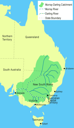
, whose name is derived from its two major rivers, the Murray River
Murray River
The Murray River is Australia's longest river. At in length, the Murray rises in the Australian Alps, draining the western side of Australia's highest mountains and, for most of its length, meanders across Australia's inland plains, forming the border between New South Wales and Victoria as it...
and the Darling River
Darling River
The Darling River is the third longest river in Australia, measuring from its source in northern New South Wales to its confluence with the Murray River at Wentworth, New South Wales. Including its longest contiguous tributaries it is long, making it the longest river system in Australia.The...
. It drains one-seventh of the Australia
Australia
Australia , officially the Commonwealth of Australia, is a country in the Southern Hemisphere comprising the mainland of the Australian continent, the island of Tasmania, and numerous smaller islands in the Indian and Pacific Oceans. It is the world's sixth-largest country by total area...
n land mass, and is currently by far the most significant agricultural area in Australia. It spans most of the states of New South Wales
New South Wales
New South Wales is a state of :Australia, located in the east of the country. It is bordered by Queensland, Victoria and South Australia to the north, south and west respectively. To the east, the state is bordered by the Tasman Sea, which forms part of the Pacific Ocean. New South Wales...
, Victoria
Victoria (Australia)
Victoria is the second most populous state in Australia. Geographically the smallest mainland state, Victoria is bordered by New South Wales, South Australia, and Tasmania on Boundary Islet to the north, west and south respectively....
, and the Australian Capital Territory, and parts of the states of Queensland
Queensland
Queensland is a state of Australia, occupying the north-eastern section of the mainland continent. It is bordered by the Northern Territory, South Australia and New South Wales to the west, south-west and south respectively. To the east, Queensland is bordered by the Coral Sea and Pacific Ocean...
(lower third) and South Australia
South Australia
South Australia is a state of Australia in the southern central part of the country. It covers some of the most arid parts of the continent; with a total land area of , it is the fourth largest of Australia's six states and two territories.South Australia shares borders with all of the mainland...
(south-east corner). It is 3375 kilometres (2,097.1 mi) in length (the Murray River is 2589 km (1,608.7 mi) long).
Most of the 1061469 km² (409,835.5 sq mi) basin
Drainage basin
A drainage basin is an extent or an area of land where surface water from rain and melting snow or ice converges to a single point, usually the exit of the basin, where the waters join another waterbody, such as a river, lake, reservoir, estuary, wetland, sea, or ocean...
is flat, low-lying and far inland, and receives little direct rainfall. The many river
River
A river is a natural watercourse, usually freshwater, flowing towards an ocean, a lake, a sea, or another river. In a few cases, a river simply flows into the ground or dries up completely before reaching another body of water. Small rivers may also be called by several other names, including...
s it contains tend to be long and slow-flowing, and carry a volume of water that is large only by Australian standards.
Native fauna
The Murray Darling Basin is home for many native animal species. The true numbers are not known, but a fairly confident estimate has been made of these animals and the current status of their population. Among the indigenous fauna in the region, the study found that there were:- 85 species of mammals, with 20 extinct and 16 endangered.
- 53 species of frogs, with none endangered.
- 46 species of snakes, with 5 endangered.
- 5 species of tortoises, with none endangered
- 34 species of fish, with none endangered.
Introduced species

Carp
Carp are various species of oily freshwater fish of the family Cyprinidae, a very large group of fish native to Europe and Asia. The cypriniformes are traditionally grouped with the Characiformes, Siluriformes and Gymnotiformes to create the superorder Ostariophysi, since these groups have certain...
.
Introduced in around 1851, the four varieties of carp were used to stock up fish dams. Since then they have made their way into the river systems, where they spread quite quickly. These fish are very mobile, as they can travel easily on flood waters and their eggs can be transported by birds.
These fish are a problem because they feed by sucking gravel from the river bed and taking all the edible material off it, before returning the rest to the water. This stirs up all the sediment, reducing the quality of the water. When caught by a fisherman, it must be killed by law.
Physiography
This area is one of the physiographic provinces of the larger East Australian Basins division, and encompasses the smaller Naracoorte Platform and Encounter Shelf physiographic sections.Hydrology
Total water flow in the Murray-Darling basin 1885 to the present has averaged around 24,000 gigalitres per year. This is the lowest rate of the world's major river systems. In most years only half of this quantity reaches the sea and in dry years much less. Estimated total annual flows for the basin have ranged from 5,000 gigalitres in 1902 to 57,000 gigalitres in 1956. Despite the magnitude of the basin, the hydrology of the streams within it is quite varied.These waters are divided into three types:
- The Darling and Lachlan basins. These have extremely variable flows from year to year, with the smallest annual flow being typically as little as 1 percent of the long-term mean and the largest often more than ten times the mean. Periods of zero flow in most rivers can extend to months and in the drier parts (Warrego, Paroo and Lower Darling basins) to years. Flows in these rivers are not strongly seasonal. In the northern regions the majority of floods occur in the summer from monsoonal penetration. For most of the Darling and Lachlan catchments it is typical to see high or low flows begin in winter and extend to the following autumn (see El Niño). High water extraction rates for irrigation and mining have heavily compromised these rivers.
- The south-western basins (Campaspe, Loddon, Avoca, Wimmera). These have a marked winter rainfall maximum and relatively lower precipitation variability than the Lachlan or Darling. However, the age and infertility of the soils mean that run-off ratios are exceedingly low (for comparison, around a tenth that of a EuropeEuropeEurope is, by convention, one of the world's seven continents. Comprising the westernmost peninsula of Eurasia, Europe is generally 'divided' from Asia to its east by the watershed divides of the Ural and Caucasus Mountains, the Ural River, the Caspian and Black Seas, and the waterways connecting...
an or North AmericaNorth AmericaNorth America is a continent wholly within the Northern Hemisphere and almost wholly within the Western Hemisphere. It is also considered a northern subcontinent of the Americas...
n catchment with a similar climate). Thus, variability of runoff is very high and most of the terminal lakes found in these basins very frequently dry up. Almost all runoff occurs in the winter and spring and, in the absence of large dams for regulation, these rivers are often seasonally dry during summer and autumn.
- A number of small catchments in South Australia, of which the largest are the Angas River flowing through StrathalbynStrathalbyn, South AustraliaStrathalbyn is a town in South Australia, in the Alexandrina Council. The town has a population of 3894 people.-History and Culture:The town was founded in 1839. Strathalbyn was once connected by broad gauge horse tram to Goolwa and Victor Harbor from 1869, and the line was extended to Mount Barker...
and the Finniss River further west, are part of the Murray-Darling Basin. These catchments lead to Lake Alexandrina, one of the lakes at the end of the Murray system. The Angas River is often dry in summer because of high levels of water extraction. The Finniss River has permanent flow which previously went into Lake Alexandrina but now has been cut off by a weirWeirA weir is a small overflow dam used to alter the flow characteristics of a river or stream. In most cases weirs take the form of a barrier across the river that causes water to pool behind the structure , but allows water to flow over the top...
. The Finniss now fills the Goolwa Channel for recreational boating.
- The Murrumbidgee, Murray and Goulburn basins (except the Broken River which resembles the south-western basins). Because these catchments have headwaters in alpine country with relatively young peatyHistosolIn both the FAO soil classification and the USA soil taxonomy, a histosol is a soil consisting primarily of organic materials. They are defined as having or more of organic soil material in the upper . Organic soil material has an organic carbon content of 12 to 18 percent, or more, depending on...
soilSoilSoil is a natural body consisting of layers of mineral constituents of variable thicknesses, which differ from the parent materials in their morphological, physical, chemical, and mineralogical characteristics...
s, the runoff ratios are much higher than in other parts of the basin. Consequently, although gross precipitation variability is no lower than in the Lachlan or Darling basins, runoff variability is markedly lower than in other parts of the basin. Typically these rivers never cease to flow and the smallest annual flow is typically around 30 percent of the long-term mean and the largest around three times the mean. In most cases the flow peaks very strongly with the spring snow melt and troughs in mid-autumn.
Of the approximately 13,000 gigalitres of flow in the basin, which studies have shown to be divertible, 11,500 gigalitres are removed for irrigation, industrial use, and domestic supply. Agricultural irrigation accounts for about 95% of the water removed, including for the growing of rice
Rice
Rice is the seed of the monocot plants Oryza sativa or Oryza glaberrima . As a cereal grain, it is the most important staple food for a large part of the world's human population, especially in East Asia, Southeast Asia, South Asia, the Middle East, and the West Indies...
and cotton
Cotton
Cotton is a soft, fluffy staple fiber that grows in a boll, or protective capsule, around the seeds of cotton plants of the genus Gossypium. The fiber is almost pure cellulose. The botanical purpose of cotton fiber is to aid in seed dispersal....
. This extraction is highly controversial among scientists in Australia, regarding the agriculture industry's high water use in a region extremely short of water (as much due to exceptionally low run-off coefficients as to low rainfall).
Rivers in the Murray-Darling Basin
- Darling RiverDarling RiverThe Darling River is the third longest river in Australia, measuring from its source in northern New South Wales to its confluence with the Murray River at Wentworth, New South Wales. Including its longest contiguous tributaries it is long, making it the longest river system in Australia.The...
- western New South WalesNew South WalesNew South Wales is a state of :Australia, located in the east of the country. It is bordered by Queensland, Victoria and South Australia to the north, south and west respectively. To the east, the state is bordered by the Tasman Sea, which forms part of the Pacific Ocean. New South Wales...
: from the confluenceConfluenceConfluence, in geography, describes the meeting of two or more bodies of water.Confluence may also refer to:* Confluence , a property of term rewriting systems...
of the CulgoaCulgoa RiverThe Culgoa River is a continuation of one branch of the Balonne River in southern Queensland and flows south-west to join the Darling River near Bourke, New South Wales. It is named for the Aboriginal word meaning "Running Through". Tributaries of the Culgoa include Nebine, Mungallala and Wallam...
and BarwonBarwon River (New South Wales)The Barwon River flows through New South Wales, virtually as a continuation of the Macintyre River / Border Rivers system, before joining with the Culgoa River to form the Darling River...
rivers which, in turn, originate from tributaries in QueenslandQueenslandQueensland is a state of Australia, occupying the north-eastern section of the mainland continent. It is bordered by the Northern Territory, South Australia and New South Wales to the west, south-west and south respectively. To the east, Queensland is bordered by the Coral Sea and Pacific Ocean...
and northern and central New South Wales- Culgoa RiverCulgoa RiverThe Culgoa River is a continuation of one branch of the Balonne River in southern Queensland and flows south-west to join the Darling River near Bourke, New South Wales. It is named for the Aboriginal word meaning "Running Through". Tributaries of the Culgoa include Nebine, Mungallala and Wallam...
- from the most western branch of the Balonne RiverBalonne RiverThe Balonne River, part of the Murray-Darling Basin system, is a short but important part of the inland river group of south-eastern Queensland. This river is a continuation of the Condamine River. After flowing through Surat the river flows south south-westerly down through the E.J...
. Flows south-west to join the Darling River near BourkeBourkeBourke may refer to:* Bourke, New South Wales* Bourke engine* Bourke Street, Melbourne, a street in Melbourne, Australia-People with the surname:* Jamie Bourke, Australian ice hockey player...
, New South Wales
- Culgoa River
- Barwon River (New South Wales)Barwon River (New South Wales)The Barwon River flows through New South Wales, virtually as a continuation of the Macintyre River / Border Rivers system, before joining with the Culgoa River to form the Darling River...
forms a section of the border between the states of New South WalesNew South WalesNew South Wales is a state of :Australia, located in the east of the country. It is bordered by Queensland, Victoria and South Australia to the north, south and west respectively. To the east, the state is bordered by the Tasman Sea, which forms part of the Pacific Ocean. New South Wales...
and QueenslandQueenslandQueensland is a state of Australia, occupying the north-eastern section of the mainland continent. It is bordered by the Northern Territory, South Australia and New South Wales to the west, south-west and south respectively. To the east, Queensland is bordered by the Coral Sea and Pacific Ocean...
.- Macintyre RiverMacIntyre RiverThe Macintyre River is a river in northern New South Wales, Australia, part of which forms the border with Queensland.The headwaters of the Macintyre River rise west of Guyra and south of Glen Innes on the Northern Tablelands...
(formed from rivers known as the "Border Rivers")
- Macintyre River
- Dumaresq RiverDumaresq RiverThe Dumaresq River forms part of the border between Queensland and New South Wales. The Severn River is its principal tributary and the Dumaresq in turn is a tributary of the Macintyre River...
- also forms part of the border between the states of New South WalesNew South WalesNew South Wales is a state of :Australia, located in the east of the country. It is bordered by Queensland, Victoria and South Australia to the north, south and west respectively. To the east, the state is bordered by the Tasman Sea, which forms part of the Pacific Ocean. New South Wales...
and QueenslandQueenslandQueensland is a state of Australia, occupying the north-eastern section of the mainland continent. It is bordered by the Northern Territory, South Australia and New South Wales to the west, south-west and south respectively. To the east, Queensland is bordered by the Coral Sea and Pacific Ocean...
.- Weir River (Queensland)
- Pike Creek (Queensland)Pike Creek (Queensland)Pike Creek is a river in southern Queensland, Australia.Pike Creek is one of the Border Rivers. Pike Creek rises south-west of Warwick, Queensland, and flows south-west for about 60 kilometers. It joins the Dumaresq River , near Texas, Queensland.The Glenlyon Dam forms a water storage on Pike...
- Severn River (Queensland)Severn River (Queensland)The Severn River, in Queensland, is a small river that rises in the Sundown National Park which joins the Dumaresq River near the Tenterfield Creek and Glenlyon Dam road. The Dumaresq flows into the Macintyre River...
- Severn River (Queensland)
- Mole River (New South Wales)Mole River (New South Wales)The Mole River is a river in northern New South Wales, Australia.The source of the Mole River lies in the Great Dividing Range, between Glen Innes and Tenterfield in the northern part of the New England highlands. The Mole River flows generally to the west and flows into the Dumaresq River...
,- Beardy RiverBeardy RiverThe Beardy River is in northern New South Wales, Australia. It rises west of Deepwater on the New England Highway and flows west and north-west, but south of the Torrington State Forest Area, crossing the Bruxner Highway before its confluence with the Dumaresq River near Maidenhead....
NSW
- Beardy River
- Macintyre Brook
- Severn River (New South Wales)Severn River (New South Wales)The Severn River * is a river in the north of New South Wales, Australia. It rises on the Northern Tablelands, New South Wales just north of Glen Innes and is wholly in NSW...
- Severn River (New South Wales)
- Beardy WatersBeardy WatersThe Beardy Waters is a river, which is about in length, in the Northern Tablelands region of New South Wales, Australia.The Beardy Waters rises near Ben Lomond Mountain south of Glen Innes in the New England region...
NSW- Bokhara RiverBokhara RiverThe Bokhara River is a river in Australia and part of the Murray-Darling basin. Forming in south western Queensland, the river passes by the town of Hebel before passing into New South Wales and eventually reaching a confluence with the Barwon River downstream from Brewarrina...
middle of three branches of the Balonne RiverBalonne RiverThe Balonne River, part of the Murray-Darling Basin system, is a short but important part of the inland river group of south-eastern Queensland. This river is a continuation of the Condamine River. After flowing through Surat the river flows south south-westerly down through the E.J...
whose main tributaries are the Condamine RiverCondamine RiverThe Condamine River, part of the Murray-Darling Basin, drains the northern portion of the Darling Downs, an area of sub-coastal southern Queensland, Australia...
from the northern Darling Downs, Qld and the MaranoaMaranoa RiverThe Maranoa River is a large river situated in south west Queensland. The Maranoa passes through Mitchell and flows south towards St George. It is a tributary of the Balonne River which eventually flows into the Darling River , so it contributes to the Murray-Darling Basin.The river rises on the...
& MerivaleMerivale RiverThe Merivale River is a river in the Maranoa district of southern Queensland. The river flows in a southerly direction and joins the Maranoa River west of Injune after rising on the southern slopes of the Carnarvon Range near Mount Moffatt....
Rivers, Qld.
- Bokhara River
- Mehi RiverMehi RiverThe Mehi River is an inland stream in north-western New South Wales which diverts from the Gwydir River, about 21 km east of Moree. From here the river flows generally west, through the town of Moree and then generally west-south-west and westwards to join the Barwon River about 11 km...
- joins the Barwon River near Collarenebri- Gwydir RiverGwydir RiverThe Gwydir River is a large inland river in the northern part of the Australian state of New South Wales which is part of the Murray-Darling Basin. The river has two main tributaries—the Horton River and the Rocky River...
- branches east of MoreeMoréeMorée is a commune in the Loir-et-Cher department of central France.-See also:*Communes of the Loir-et-Cher department...
, the main branch being the Mehi river.
- Gwydir River
- Horton River - drains most of the northern slopes of the Nandewar RangeNandewar RangeThe Nandewar Range is a mountain range east of Narrabri in New South Wales, Australia. John Oxley was the first European to see the range in 1818 as he explored the New South Wales Northern Tablelands....
. Joins the Gwydir River between the towns of Bingara and Gravesend- Rocky River (New South Wales)Rocky River (New South Wales)Rocky River is a locality in northern New South Wales, Australia near the town of Uralla on the Northern Tablelands plateau.About two kilometres west of Uralla, was the gold mining area and associated village also called Rocky River. In 1851 W.F. Buchanan and J. Lucas reported to the Maitland...
- joins the Gwydir River near Bundarra
- Rocky River (New South Wales)
- Namoi RiverNamoi RiverThe Namoi River is a major tributary of the Darling River in inland New South Wales, Australia.- Course :The headwaters of the Namoi, including the Macdonald River, the Peel River, the Cockburn River and the Manilla River, rise on the western slopes of the Great Dividing Range on the Northern...
- joins the Barwon River, near the town of Walgett- Macdonald River (Bendemeer)Macdonald River (Bendemeer)There are two rivers named Macdonald River in New South Wales, Australia. See Macdonald RiverThe Macdonald River in northern New South Wales is the headwater of the Namoi River. It rises east of Niangala on the western slopes of the Great Dividing Range on the Northern Tablelands, New South Wales...
,
- Macdonald River (Bendemeer)
- Cobrabald RiverCobrabald RiverThe Cobrabald River is a river on the Northern Tablelands of New South Wales, Australia. The headwaters of the river rise in high country on the western slopes of the Great Dividing Range about 3.2 kilometres south east of Branga Swamp and 50 kilometres south of Walcha.It flows generally north...
- Peel River (New South Wales)Peel River (New South Wales)The Peel River is a river in New South Wales, Australia. It is part of the Murray-Darling Basin.The Peel rises on the northern slopes of the Liverpool Range south of the village of Nundle. It flows generally north and west through the foothills of the Great Dividing Range, through Woolomin and...
,
- Peel River (New South Wales)
- Cockburn RiverCockburn RiverThe Cockburn River is a river in New South Wales, Australia.The Cockburn River rises near Woolbrook, New South Wales in the southern New England tablelands. It drains the western side of the Great Dividing Range...
- Manilla RiverManilla RiverThe Manilla River is a tributary of the Namoi River in northern New South Wales, Australia. Despite the name, it is officially classified as a stream by the Geographical Names Board of New South Wales....
- Manilla River
- Macquarie RiverMacquarie RiverThe Macquarie River is one of the main inland rivers in New South Wales. Its headwaters rise in the central highlands of New South Wales near the town of Oberon. The river travels generally northwest past the towns of Bathurst, Wellington, Dubbo, Narromine, and Warren to the Macquarie Marshes...
- headwaters rise in the central highlands of New South WalesNew South WalesNew South Wales is a state of :Australia, located in the east of the country. It is bordered by Queensland, Victoria and South Australia to the north, south and west respectively. To the east, the state is bordered by the Tasman Sea, which forms part of the Pacific Ocean. New South Wales...
near the town of OberonOberonOberon is a legendary king of the fairies.Oberon may also refer to:-People:* Merle Oberon , British actress* Oberon Zell-Ravenheart , Neopagan activist-Media and entertainment:* Oberon...
- Cudgegong RiverCudgegong RiverThe Cudgegong River is a tributary of the Macquarie River in New South Wales. It rises near Rylstone and flows generally north-west past Mudgee it flows past the edge of Gulgong and then into Lake Burrendong which is created by Burrendong Dam on the Macquarie River. Windamere Dam on the Cudgegong...
- Cudgegong River
- Talbragar RiverTalbragar RiverThe Talbragar River is a river in New South Wales, Australia. It starts on the western side of the Liverpool Range near Cassilis and flows west to join the Macquarie River near Dubbo. The Talbragar does not start in a high rainfall area and is not much of a river at all really. It was first...
- Castlereagh RiverCastlereagh RiverThe Castlereagh River is located in the State of New South Wales, Australia. The river rises in the heart of the Warrumbungle mountains and initially flows east through the town of Coonabarabran...
- Castlereagh River
- Marra Creek
- Bogan RiverBogan RiverThe Bogan River is an inland river in the central west of New South Wales, Australia.This river rises at Goonumbla, 19 kilometres north-west of Parkes and flows in a generally north-north-westerly direction past Tottenham, Peak Hill and through Nyngan. The Bogan River is about 590 km in length...
- rises at Goonumbla, 19 kilometres north-west of ParkesParkesParkes may refer to:* Sir Henry Parkes , Australian politician and "Father of Federation"There are also several things named after him:* Parkes, New South Wales, a regional town...
and flows in a north-westerly direction to join the Darling-Barwon near where the Culgoa river joins
- Bogan River
- Warrego RiverWarrego RiverThe Warrego River is situated in south west Queensland and north west New South Wales, Australia. It is the northernmost tributary of the Darling River....
- joins the Darling River below Bourke- Paroo RiverParoo RiverThe Paroo River is a river in Eastern Australia and is often considered to be major tributary of the Darling River in eastern Australia, although its flow generally dissipates before it reaches the Darling...
- Paroo River
- Murray RiverMurray RiverThe Murray River is Australia's longest river. At in length, the Murray rises in the Australian Alps, draining the western side of Australia's highest mountains and, for most of its length, meanders across Australia's inland plains, forming the border between New South Wales and Victoria as it...
- designated as most of the border between New South WalesNew South WalesNew South Wales is a state of :Australia, located in the east of the country. It is bordered by Queensland, Victoria and South Australia to the north, south and west respectively. To the east, the state is bordered by the Tasman Sea, which forms part of the Pacific Ocean. New South Wales...
and VictoriaVictoria (Australia)Victoria is the second most populous state in Australia. Geographically the smallest mainland state, Victoria is bordered by New South Wales, South Australia, and Tasmania on Boundary Islet to the north, west and south respectively....
- Edward RiverEdward RiverThe Edward River is a river in the south west Riverina region of New South Wales, Australia. The river is an anabranch of the Murray River, the longest river in Australia....
(anabranchAnabranchAn anabranch is a section of a river or stream that diverts from the main channel or stem of the watercourse and rejoins the main stem downstream. Local anabranches can be the result of small islands in the watercourse...
)
- Edward River
- Murrumbidgee RiverMurrumbidgee RiverThe Murrumbidgee River is a major river in the state of New South Wales, Australia, and the Australian Capital Territory . A major tributary of the Murray River, the Murrumbidgee flows in a west-northwesterly direction from the foot of Peppercorn Hill in the Fiery Range of the Snowy Mountains,...
- NSW and ACT Tantangara Dam- Cotter RiverCotter RiverThe Cotter River is a fresh water river in the Australian Capital Territory. It is a tributary of the Murrumbidgee River and part of Murray-Darling Basin. The Cotter River is one of two rivers—the Queanbeyan River is the other—that meet the water supply needs of the Canberra and...
- Cotter River
- Molonglo RiverMolonglo RiverThe Molonglo River rises on the western side of the Great Dividing Range of eastern Australia in the state of New South Wales. Its source is on the other side of the mountain range from where the Shoalhaven River rises, in Tallaganda state forest at ~1200 metres altitude...
- Queanbeyan RiverQueanbeyan RiverThe Queanbeyan River is a tributary of the Molonglo River and part of Murray-Darling Basin. The river is 70 kilometres in length and the river catchment is 96,000 hectares in size...
- Queanbeyan River
- Gudgenby RiverGudgenby RiverThe Gudgenby River is a river in the Australian Capital Territory that flows predominantly through the forests of the Namadgi National Park. The river catchment contains ecologically significant alpine wetlands...
- Naas RiverNaas RiverThe Naas River rises in the southern ranges of the Australian Capital Territory within Namadgi National Park. Its watershed boundary defines the southern border of the A.C.T. with New South Wales. It flows into the Gudgenby River near Tharwa village, to the south of Canberra....
- Naas River
- Lachlan RiverLachlan River- Course :The river rises in the central highland of New South Wales, part of the Great Dividing Range, 13 km east of Gunning. Its major headwaters, the Carcoar River, the Belubula River and the Abercrombie River converge near the town of Cowra. Minor tributaries include the Morongla Creek...
- NSW- Abercrombie RiverAbercrombie RiverThe Abercrombie River is a river in New South Wales, Australia, flowing from Mount Werong westward to the Wyangala Dam near Cowra. The river is a tributary of the Lachlan, which it joins at Wyangala lake....
- Abercrombie River
- Yass RiverYass RiverThe Yass River is a river in the state of New South Wales, Australia. The town of Yass is located on the Yass River a short distance from its confluence with the Murrumbidgee River.There are two competing theories as to the origin of the name Yass...
- Tumut RiverTumut RiverThe Tumut River is a river in New South Wales, Australia.The Tumut River rises on the northern face of Mount Jagungal in the Snowy Mountains of southern New South Wales. It flows about 145km before joining the Murrumbidgee River, at Darbalara near the town of Gundagai...
- joins the Murrumbidgee River, at Darbalara near the town of Gundagai.
- Tumut River
- Goodradigbee RiverGoodradigbee RiverThe Goodradigbee River is in south-eastern New South Wales, Australia. It flows into Burrinjuck Dam and thus is a tributary of the Murrumbidgee River....
- Numeralla RiverNumeralla RiverThe Numeralla river in New South Wales, Australia, is a diverse ecosystem rich with many different animal species such as the uncommonly seen Wanderer's Kingfisher and the Kiora frog...
- joins the upper Murrumbidgee River near Bredbo.
- Numeralla River
- Avoca RiverAvoca RiverThe Avoca River drains a substantial part of Victoria, the southernmost state of mainland Australia. The river rises at the foot of Mount Lonarch in the Central Highlands near the small town of Amphitheatre, and flows north for 270 km through Avoca, Charlton and Quambatook...
- Loddon RiverLoddon RiverThe Loddon River is a 392-km long tributary of the Murray River that flows through central and northern Victoria, Australia. The river rises near Trentham and flows by Glenlyon. It then flows generally northward through Guildford and Newstead, 40 km west of Bendigo through the Cairn Curran...
- Loddon River
- Campaspe RiverCampaspe RiverThe Campaspe River is a river in Victoria, Australia. It was named by Major Mitchell in 1836 for Campaspe, a mistress of Alexander the Great.The river was known as yalooka by the local aboriginal people of the Rochester area.-Course:...
- meets the Murray River near the town of Echuca- Goulburn River
- Broken RiverBroken River (Victoria)The Broken River is a minor river in Victoria, Australia that is a part of the larger Murray-Darling Basin. It flows into the Goulburn River near Shepparton...
- Jamieson RiverJamieson RiverThe Jamieson River is a inland river in Victoria, Australia. The river rises in Alpine National Park and flows into the Goulburn River at the town of Jamieson. Its tributaries are Jamieson River north branch and Jamieson River south branch....
- Jamieson River
- Howqua RiverHowqua RiverThe Howqua River is a river in south-eastern Australia. It originates on the slopes of Mount Howitt before flowing through the Alpine National Park in Victoria...
- Ovens RiverOvens RiverThe Ovens River is a river in the Australian state of Victoria.Hamilton Hume and William Hovell explored the area in 1824, naming the Ovens River...
- Ovens River
- King River
- Buffalo River
- Buckland RiverBuckland River (Victoria)The Buckland River is a river in north eastern Victoria, Australia. With its source in the Victorian Alps, it reaches a confluence with the Ovens River immediately downstream from the small town of Porepunkah....
- Kiewa RiverKiewa RiverThe Kiewa River is a major tributary of the Murray River in Australia.The river's headwaters include Victoria's highest mountain, Mount Bogong, and wind their way north-west about 100 kilometres, gradually slowing before joining the Murray east of Albury....
- joins the Murray east of AlburyAlbury-Places:*Albury, New South Wales, Australia** Electoral district of Albury is an electoral district in the New South Wales Legislative Assembly, based around the area.*Albury, Hertfordshire, England*Albury, Oxfordshire, England*Albury, Surrey, England...
.
- Kiewa River
- Mitta Mitta RiverMitta Mitta RiverThe Mitta Mitta River is a major tributary of the Murray River in Australia and the source of approximately 40% of the Murray's flow.The river's headwaters include Victoria's highest mountain, Mount Bogong, with the Mitta Mitta itself forming at the confluence of the Cobungra River and the Big...
- the source of approximately 40% of the Murray River's flow.- Cobungra RiverCobungra RiverThe Cobungra River is a river of Gippsland in eastern Victoria, Australia.The Cobungra River rises below the slopes of the ski resort at Mount Hotham and Mount Loch...
- Cobungra River
- Big River, just south of Anglers Rest, VictoriaAnglers Rest, VictoriaAnglers Rest is a locality in Victoria, Australia. It is on the Omeo Highway, north of Omeo in the Shire of East Gippsland, almost totally surrounded by the Alpine National Park...
Management
The basin covers five states and territory governments, who according to the ConstitutionConstitution of Australia
The Constitution of Australia is the supreme law under which the Australian Commonwealth Government operates. It consists of several documents. The most important is the Constitution of the Commonwealth of Australia...
, are responsible for managing water resources. The River Murray Commission was established in 1917. Under the River Murray Waters Agreement, which never included Queensland despite the state containing about a quarter of the basin, the Commission's role was only as an advisory body with no authority for the enforcement of provisions. For a long time the Commission was only concerned with water quantity until salinity
Salinity in Australia
Soil salinity and dryland salinity are two problems degrading the environment of Australia. Salinity is a concern in most states, but especially in the south-west of Western Australia....
became a problem. This led to minor reforms in 1982 in which water quality
Water quality
Water quality is the physical, chemical and biological characteristics of water. It is a measure of the condition of water relative to the requirements of one or more biotic species and or to any human need or purpose. It is most frequently used by reference to a set of standards against which...
became part of the Commission's responsibilities. However, it was soon recognised that a new organisational structure which considered the national perspective was needed for effective management.
The Murray-Darling Basin Agreement was first adopted in 1985 but it wasn't until 1993 that its full legal status was in-acted. The Agreement led to the creation of a number of new organisations under what is known as the Murray-Darling Basin Initiative. These included the Murray-Darling Basin Ministerial Council and the Murray Darling Basin Commission.
The Murray-Darling Basin Plan
In October 2010, The Murray-Darling Basin Authority released a major document outlining its plan to secure the long-term ecological healthEcological health
Ecological health or ecological integrity or ecological damage are the symptoms of an ecosystem's pending loss of carrying capacity, its ability to perform ecological services, or a pending ecocide, due to cumulative causes such as pollution. it can also be defined as farming so as to minimize the...
of the Murray-Darling Basin. This entails cutting existing water allocations and increasing environmental flows. The document is officially titled the Guide to the Proposed Murray-Darling Basin Plan. It is the first part of a three-stage process to address the problems of the Murray-Darling Basin. MDBA is responsible for preparing and overseeing a legally-enforceable management plan—the Basin Plan.
The Basin Plan is designed to set and enforce environmentally sustainable limits on the quantities of water that may be taken from Basin water resources, to set Basin-wide environmental, water quality
Water quality
Water quality is the physical, chemical and biological characteristics of water. It is a measure of the condition of water relative to the requirements of one or more biotic species and or to any human need or purpose. It is most frequently used by reference to a set of standards against which...
and salinity
Salinity in Australia
Soil salinity and dryland salinity are two problems degrading the environment of Australia. Salinity is a concern in most states, but especially in the south-west of Western Australia....
objectives, to develop efficient water trading
Water trading
Water trading is the process of buying and selling of water access entitlements, also often called water rights. The terms of the trade can be either permanent or temporary, depending on the legal status of the water rights. Some of the western states of the United States, Chile, South Africa,...
regimes across the Basin, to set requirements for state water resource plans and to improve water security for all Basin users. It also intends to optimise social and economic impacts once these environmental outcomes have been met.
With the release of the Guide to the Proposed Murray-Darling Basin Plan there have been a number of protests and voiced concerns about the plan in rural towns that the MDBA have visited to present the plan to consultation meetings. Over 5,000 people attended a MDBA meeting in Griffith where Griffith Mayor, Mike Neville, said the plan would "obliterate" Murrumbidgee
Murrumbidgee River
The Murrumbidgee River is a major river in the state of New South Wales, Australia, and the Australian Capital Territory . A major tributary of the Murray River, the Murrumbidgee flows in a west-northwesterly direction from the foot of Peppercorn Hill in the Fiery Range of the Snowy Mountains,...
valley communities. Other groups also echo this feeling, such as the Victorian Farmers Federation and Wine Group Growers' Australia. Conversely, support for the Murray-Darling Basin plan has been received by various groups, including Australian Conservation Foundation
Australian Conservation Foundation
The Australian Conservation Foundation is an Australian non-profit, community-based environmental organisation focused on advocacy, policy research and community outreach.-History:...
, and Environment Victoria
Environment Victoria
Environment Victoria is Victoria’s leading independent environment group. Established in 1969 as the Conservation Council of Victoria, Environment Victoria was set up by Victoria's community conservation groups to provide a single unified voice for Victoria's environment. Today, Environment...
.
New legal advice from lawyers for the Federal Government is changing the plan. The Government's reading is that the plan must give equal weight to the environmental, social and economic impacts of proposed cuts to irrigation. Environmentalists and South Australian irrigators, at the end of the river in South Australia, say the authority should stick to its original figure.
In October 2010, a parliamentary inquiry into the economic impacts of the plan was announced.
In late October 2010 the Water Minister, Tony Burke, played down the prospect of a High Court challenge to the Murray-Darling Basin plan, as confusion continued over new legal advice released by the Government. In response to community concerns that the Murray-Darling Basin Authority had put environmental issues first over social and economic needs, Burke released new advice on the requirements of the Water Act. Burke stated that the Act does allow for the authority to 'optimise' the needs of all three areas, but constitutional lawyer, George Williams, had cast doubts over the interpretation of the laws, stating it could be subject to a legal challenge.
The MDBA announced in November 2010 that it might be forced to push back the release of its final plan for the river system until early 2012.
The MDBA chairman, Mike Taylor, reassured the public meeting that more work is being done to look at how the proposed cuts would affect regional communities. He stated; "Importantly, we want to make sure the social and economic impacts—which under any sort of scenario is very significant—were fully teased out". Taylor resigned as he believed that the overriding principle should be the environmental outcome which was in conflict with the Gillard Government and following a period of sustained criticism of the Authority and the implementation of the proposed draft basin plan. He was replaced by former New South Wales Planning Minister, Craig Knowles
Craig Knowles
Craig John Knowles is a former Australian politician and member of the New South Wales Legislative Assembly from 1990 to 2005....
.
See also
- Climate change in AustraliaClimate change in AustraliaClimate change has become a major issue in Australia due to drastic climate events since the turn of the 21st century that have focused government and public attention. Rainfall in Australia has increased slightly over the past century, although there is little or no trend in rainfall in northeast...
- Murray-Darling CapMurray-Darling CapThe Murray-Darling Cap is a policy limiting the water diversions in the Murray-Darling Basin at 1993 levels. It seeks to strike a balance between the amount of water available to irrigators and the security of their water supply. At the time of conception in 1997, the level of diversions from the...
- Western PlateauWestern PlateauThe Western Plateau is Australia's largest drainage division and is composed predominantly of the remains of the ancient rock shield of Gondwanaland. It incorporates two thirds of the continent; 2,700,000 square kilometres of arid land including large parts of Western Australia, South Australia,...
External links
- Murray-Darling Basin Authority
- Murray-Darling Basin Water Budget Project
- Murray Darling Freshwater Research Centre
- River Murray Water Restrictions
- Murray Outback - Guide to the major towns on the Murray and Murray Outback Region.
- Save the Murray - lobby group
- Murray Darling Basin Resources
- The Basin Plan
- Guide to the Proposed Basin Plan
- Guide to the Basin Plan, Volumes 1 - 21
- Basin Plan - lobby group
News
- Fire, Flood and Acid Mud - ABC TV Catalyst