
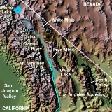
Owens River
Encyclopedia
The Owens River is a river
in southeastern California
in the United States
, approximately 183 miles (294.5 km) long. It drains into and through the Owens Valley
, an arid basin between the eastern slope of the Sierra Nevada and the western faces of the Inyo
and White Mountains
. The river terminates at Owens Lake
, but its flow is greatly diminished by diversion into the Los Angeles Aqueduct
since 1913. It is a major example and cause in the long-running California Water Wars
, about urban region irrigation
and drinking water
export and local ecosystem and agricultural needs. In winter 2006, the Los Angeles Department of Water and Power
restored 5% of the pre-aqueduct flow to the river, by court order, allowing the Owens River Gorge
, the river bed in the valley, and Owens Lake to contain a small amount of water.
, approximately 20 miles (32.2 km) south of Mono Lake
and 25 miles (40.2 km) east of Yosemite Village. It flows southeast across the Long Valley Caldera
, through Lake Crowley reservoir, then descends through the 10 miles (16.1 km) Owens River Gorge
, emerging at the north end of the Owens Valley north of Bishop
. In the area around Bishop, it is diverted through many ditches to irrigate the surrounding farming region. It flows south-southeast through the Owens Valley between the Sierra Nevada on the west and the White
and Inyo Mountains
on the east, past Big Pine
. Approximately 10 miles (16.1 km) south-southeast of Big Pine, most of the remaining river is diverted into the Los Angeles Aqueduct
, completed in 1913 to supply municipal, recreational and agricultural water to Los Angeles
. The remaining river flows through the southern valley, flanked by the Los Angeles Aqueduct, past Lone Pine
, entering the lake bed of predominantly dry Owens Lake
at the southern end of Owens Valley.
– the Long Valley and Owens Valley. The north to south drainage basin
is in portions of Mono
and Inyo Counties
and terminates in the now-dry Owens Lake. To the northwest of the valley is the Long Valley Caldera
which is only a fraction of the size of the Owens Valley. The Owens River enters Owens Valley from the northwest, while the Spring Valley Wash drains the northernmost part of the valley, extending a tiny portion of the basin into Nevada
. The river flows mainly on the east side of the valley, because alluvial deposits from Sierra Nevada streams have forced the river channel in that direction.
Vertical relief in the basin is immense – elevations range from 14494 feet (4,417.8 m) at Mount Whitney
, the highest peak in the continental United States, to 3556 feet (1,083.9 m) on the surface of Owens Lake. The Owens River itself heads at an elevation of 7291 feet (2,222.3 m). Few people inhabit the sparse, open grasslands and steep mountainsides of the watershed; the 2009 population of Mono County was about 12,927 while Inyo County had some 17,293 inhabitants. The largest city on the river is Bishop, with a population of slightly less than 3,600. Other significant towns include Lone Pine (population 1,655), Big Pine (population 1,350), and Independence (population 574).
. The Owens Valley is a graben
or rift valley
, a section of land that has dropped down between two parallel faults, while the land on either side has risen. This has resulted in the flat floor and steep, towering walls of the present-day valley. With the Sierra Nevada on the west side and the Inyo Mountains
and White Mountains
on the east, with the highest peaks of either range rising to over 14000 feet (4,267.2 m) and the floor of the valley at a comparatively low 3000 to 4000 ft (914.4 to 1,219.2 m), the Owens River flows in one of the deepest valleys in the United States.
Further to the north, the Owens River basin encompasses predominantly igneous rock
s and vast remnants of past volcanic activity. The upper 30 miles (48.3 km) of the river run through the Long Valley Caldera
, an enormous 20 miles (32.2 km)-wide crater formed by a volcanic eruption some 760,000 years ago. The eruption's resulting ash cloud covered much of the southwestern United States, including parts of ten U.S. state
s.
Mammoth Mountain
, to the southwest (more popularly known as a major ski area) also formed from eruptions related to the Long Valley Caldera. To the north of the Caldera, extending to the Mono Lake
area, lie the chain of Mono-Inyo Craters
, which range in age from 400,000 to 500 years old.
During the Pleistocene
at the end of the last glacial period, melting glaciers in the Sierra Nevada and Inyo/White Mountains fed prodigious amounts of runoff into the Owens River, causing it to expand to many times its current size. The increased volume of the river caused Owens Lake to rise as well, eventually spilling out the south side of the valley into the Mojave Desert
. Ancient, now-abandoned river channels suggest that the extended Owens River ran south to China Lake, then east into Searles Lake
, north into the Panamint Valley
(where it formed Panamint Lake) and finally east into Death Valley
and the ancient Lake Manly
. This great inland sea was also fed by the Mojave River
from the south, the Amargosa River
from the east and the Death Valley Wash from the north. During this relatively short time, the Owens River became part of a vast interior drainage system that stretched east to west covering over 8000 mi2. During the peak of runoff, water from this massive basin may have even escaped to the Colorado River
through a valley leading to the southeast.
 For thousands of years the Owens River valley was inhabited by the seminomadic Owens Valley Northern Paiute
and the Shoshone
tribes of Native Americans. The indigenous name for the river was Wakopee, while they called Owens Lake Pacheta. In the upper Owens Valley lie traces of some of California's first irrigation
systems, created by Paiute groups to water small patches of crops. It is believed that native people in the upper portion of the valley once built dams across the Owens River (and possibly one of its major tributaries, Bishop Creek) to divert water into local canals. The switch from a hunter-gatherer
to a settled, agricultural lifestyle is probably the result of the climate of the Owens Valley becoming drier some 1,000 years ago.
Typically, the Native Americans would build dams across the river or a tributary stream in the spring, out of materials including boulders, dirt, reeds, grass or other elements. The watercourse below the dam would then be desiccated, and the water led by canal to the irrigated plot of land, typically no more than a few square miles. Directly after the dam was closed and the river dried up, fish trapped on the dry riverbed would then be gathered and eaten. Before winter storms caused floods, the dam would be breached, allowing the river to flow naturally again, while fish would be collected in the dried-up river channel. By then, there would be enough food stored to last the winter in which the cropland would lie fallow.
In the nineteenth century, the Owens River was first seen by American explorers. One of the first explorers was John C. Fremont
, who led a cartographic expedition to the Owens Valley in 1845. His party included Kit Carson
, Edward Kern
and Richard Owens, the latter for whom the river, lake and valley are named. Other well-known adventurers included Jedediah Smith
and Joseph R. Walker, who also came into the area in the 1800s. Gradually, the river's surroundings were settled by farmers and ranchers. The valley never accumulated a very large population, but mining activities brought significant income to the new inhabitants of the area. Ore
was shipped down the Owens River from the north, and also borax
and silver
from Death Valley
to the east. Up until 1924, Owens Lake was still so large that a steamboat ferry operated between its east and west sides, ferrying freight and passengers across in three hours, much less than the three days required to semi-circumnavigate the lake. In 1872, the Lone Pine earthquake
killed 27 people in the Owens Valley, mostly in Lone Pine.
(LADWP) has recently decided to trap beaver (Castor canadensis) out of the Owens Valley, claiming that beaver are damming flows into their diversions of water to Los Angeles
. This decision runs counter to an independent assessment commissioned by LADWP and the Inyo County Water Department in 1997, where it was recommended that beaver be maintained in reasonable populations and their dams left in place because "Although beaver activity has resulted in the removal of much willow and other shrub and woody vegetation and the dams create favorable tule conditions and reduce fish spawning habitat, they also provide important fish rearing habitat, mesic meadows, and promote the growth of other riparian species. It is most likely that the physical removal of beaver dams will result in more adverse environmental impacts than environmental benefits."
Beaver were re-introduced to the Owens Valley by the California Department of Fish and Game
in 1948 in Baker Creek, and have since spread throughout the Owens Valley. Although it is controversial whether beaver were once native to the Owens Valley, there is growing evidence that they were native to the eastern slope of the Sierra Nevada. In particular, the northern Paiute of Walker Lake
, Honey Lake
and Pyramid Lake have a word for beaver su-i'-tu-ti-kut'-teh. When Stephen Powers
visited the northern Paiute to collect Indian materials for the Smithsonian Institution
in preparation for the Centennial Exhibition of 1876
, he reported that the northern Paiute wrapped their hair in strips of beaver fur, made medicine from parts of beaver and that their creation legend included beaver. In addition, fur trapper Stephen Hall Meek
"set his traps on the Truckee River in 1833", which strongly suggests that he saw beaver or beaver sign. Supporting this line of evidence, Tappe records in 1941 an eyewitness who said beaver were plentiful on the upper part of the Carson River and its tributaries in Alpine County until 1892 when they fell victim to heavy trapping.
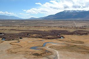
was highly controversial and led to violence and sabotage by local residents in the 1920s. The diversion of water and the subsequent desiccation
of Owens Lake remains highly controversial, and the restoration of the lake has been a long-time goal of the California environmentalist
community. The lower Owens River and Owens Lake were left dry by the 1913 diversions, until lawsuits forced LADWP to start releasing water into the 62 mile long lower Owens River in December, 2006. In less than one year, the lower Owens River was teeming with fish, birds and other wildlife.
River
A river is a natural watercourse, usually freshwater, flowing towards an ocean, a lake, a sea, or another river. In a few cases, a river simply flows into the ground or dries up completely before reaching another body of water. Small rivers may also be called by several other names, including...
in southeastern California
California
California is a state located on the West Coast of the United States. It is by far the most populous U.S. state, and the third-largest by land area...
in the United States
United States
The United States of America is a federal constitutional republic comprising fifty states and a federal district...
, approximately 183 miles (294.5 km) long. It drains into and through the Owens Valley
Owens Valley
Owens Valley is the arid valley of the Owens River in eastern California in the United States, to the east of the Sierra Nevada and west of the White Mountains and Inyo Mountains on the west edge of the Great Basin section...
, an arid basin between the eastern slope of the Sierra Nevada and the western faces of the Inyo
Inyo Mountains
The Inyo Mountains are a short mountain range east of the Sierra Nevada mountains in eastern California in the United States. The range separates the Owens Valley to the west with Saline Valley to the east, extending for approximately 70 mi SSE from the southern end of the White Mountains,...
and White Mountains
White Mountains (California)
The White Mountains of California are a triangular fault block mountain range facing the Sierra Nevada across the upper Owens Valley. They extend for approximately as a greatly elevated plateau about wide on the south, narrowing to a point at the north, with elevations generally increasing...
. The river terminates at Owens Lake
Owens Lake
Owens Lake is a mostly dry lake in the Owens Valley on the eastern side of the Sierra Nevada in Inyo County, California. It is located about south of Lone Pine, California...
, but its flow is greatly diminished by diversion into the Los Angeles Aqueduct
Los Angeles Aqueduct
The Los Angeles Aqueduct system comprising the Los Angeles Aqueduct and the Second Los Angeles Aqueduct, is a water conveyance system operated by the Los Angeles Department of Water and Power...
since 1913. It is a major example and cause in the long-running California Water Wars
California Water Wars
The California Water Wars were a series of conflicts between the city of Los Angeles, farmers and ranchers in the Owens Valley of Eastern California, and environmentalists. As Los Angeles grew in the late 1800s, it started to outgrow its water supply. Fred Eaton, mayor of Los Angeles, realized that...
, about urban region irrigation
Irrigation
Irrigation may be defined as the science of artificial application of water to the land or soil. It is used to assist in the growing of agricultural crops, maintenance of landscapes, and revegetation of disturbed soils in dry areas and during periods of inadequate rainfall...
and drinking water
Drinking water
Drinking water or potable water is water pure enough to be consumed or used with low risk of immediate or long term harm. In most developed countries, the water supplied to households, commerce and industry is all of drinking water standard, even though only a very small proportion is actually...
export and local ecosystem and agricultural needs. In winter 2006, the Los Angeles Department of Water and Power
Los Angeles Department of Water and Power
The Los Angeles Department of Water and Power is the largest municipal utility in the United States, serving over four million residents. It was founded in 1902 to supply water and electricity to residents and businesses in Los Angeles and surrounding communities...
restored 5% of the pre-aqueduct flow to the river, by court order, allowing the Owens River Gorge
Owens River Gorge
The Owens River Gorge is a steep 10 mi canyon on the upper Owens River in eastern California in the United States. The canyon is located at the eastern edge of the Sierra Nevada mountains in southern Mono County, along the stretch of the river where it exits the Long Valley near its source...
, the river bed in the valley, and Owens Lake to contain a small amount of water.
Course
The river rises in the Sierra Nevada in southwestern Mono CountyMono County, California
Mono County is a county located in the east central portion of the U.S. state of California, to the east of the Sierra Nevada between Yosemite National Park and Nevada. As of the 2010 census, the population was 14,202, up from 12,853 at the 2000 census...
, approximately 20 miles (32.2 km) south of Mono Lake
Mono Lake
Mono Lake is a large, shallow saline lake in Mono County, California, formed at least 760,000 years ago as a terminal lake in a basin that has no outlet to the ocean...
and 25 miles (40.2 km) east of Yosemite Village. It flows southeast across the Long Valley Caldera
Long Valley Caldera
Long Valley Caldera is a depression in eastern California that is adjacent to Mammoth Mountain. The valley is one of the largest calderas on earth, measuring about long and wide . The elevation of the floor of the caldera is in the east and in the west...
, through Lake Crowley reservoir, then descends through the 10 miles (16.1 km) Owens River Gorge
Owens River Gorge
The Owens River Gorge is a steep 10 mi canyon on the upper Owens River in eastern California in the United States. The canyon is located at the eastern edge of the Sierra Nevada mountains in southern Mono County, along the stretch of the river where it exits the Long Valley near its source...
, emerging at the north end of the Owens Valley north of Bishop
Bishop, California
Bishop is a city in Inyo County, California, United States. Though Bishop is the only city and the largest populated place in Inyo County, the county seat is Independence. Bishop is located near the northern end of the Owens Valley, at an elevation of 4147 feet . The population was 3,879 at the...
. In the area around Bishop, it is diverted through many ditches to irrigate the surrounding farming region. It flows south-southeast through the Owens Valley between the Sierra Nevada on the west and the White
White Mountains (California)
The White Mountains of California are a triangular fault block mountain range facing the Sierra Nevada across the upper Owens Valley. They extend for approximately as a greatly elevated plateau about wide on the south, narrowing to a point at the north, with elevations generally increasing...
and Inyo Mountains
Inyo Mountains
The Inyo Mountains are a short mountain range east of the Sierra Nevada mountains in eastern California in the United States. The range separates the Owens Valley to the west with Saline Valley to the east, extending for approximately 70 mi SSE from the southern end of the White Mountains,...
on the east, past Big Pine
Big Pine, California
Big Pine is a census-designated place in Inyo County, California, United States. Big Pine is located south-southeast of Bishop, at an elevation of 3990 feet . The population was 1,756 at the 2010 census, up from 1,350 at the 2000 census...
. Approximately 10 miles (16.1 km) south-southeast of Big Pine, most of the remaining river is diverted into the Los Angeles Aqueduct
Los Angeles Aqueduct
The Los Angeles Aqueduct system comprising the Los Angeles Aqueduct and the Second Los Angeles Aqueduct, is a water conveyance system operated by the Los Angeles Department of Water and Power...
, completed in 1913 to supply municipal, recreational and agricultural water to Los Angeles
Los Angeles, California
Los Angeles , with a population at the 2010 United States Census of 3,792,621, is the most populous city in California, USA and the second most populous in the United States, after New York City. It has an area of , and is located in Southern California...
. The remaining river flows through the southern valley, flanked by the Los Angeles Aqueduct, past Lone Pine
Lone Pine, California
Lone Pine is a census-designated place in Inyo County, California, United States. Lone Pine is located south-southeast of Independence, at an elevation of 3727 feet . The population was 2,035 at the 2010 census, up from 1,655 at the 2000 census. The town is located in the Owens Valley, near the...
, entering the lake bed of predominantly dry Owens Lake
Owens Lake
Owens Lake is a mostly dry lake in the Owens Valley on the eastern side of the Sierra Nevada in Inyo County, California. It is located about south of Lone Pine, California...
at the southern end of Owens Valley.
Watershed
The river flows through two major valleys of the extreme southwestern Great BasinGreat Basin
The Great Basin is the largest area of contiguous endorheic watersheds in North America and is noted for its arid conditions and Basin and Range topography that varies from the North American low point at Badwater Basin to the highest point of the contiguous United States, less than away at the...
– the Long Valley and Owens Valley. The north to south drainage basin
Drainage basin
A drainage basin is an extent or an area of land where surface water from rain and melting snow or ice converges to a single point, usually the exit of the basin, where the waters join another waterbody, such as a river, lake, reservoir, estuary, wetland, sea, or ocean...
is in portions of Mono
Mono County, California
Mono County is a county located in the east central portion of the U.S. state of California, to the east of the Sierra Nevada between Yosemite National Park and Nevada. As of the 2010 census, the population was 14,202, up from 12,853 at the 2000 census...
and Inyo Counties
Inyo County, California
-National protected areas:* Death Valley National Park * Inyo National Forest * Manzanar National Historic Site-Major highways:* U.S. Route 6* U.S. Route 395* State Route 127* State Route 136* State Route 168* State Route 178...
and terminates in the now-dry Owens Lake. To the northwest of the valley is the Long Valley Caldera
Long Valley Caldera
Long Valley Caldera is a depression in eastern California that is adjacent to Mammoth Mountain. The valley is one of the largest calderas on earth, measuring about long and wide . The elevation of the floor of the caldera is in the east and in the west...
which is only a fraction of the size of the Owens Valley. The Owens River enters Owens Valley from the northwest, while the Spring Valley Wash drains the northernmost part of the valley, extending a tiny portion of the basin into Nevada
Nevada
Nevada is a state in the western, mountain west, and southwestern regions of the United States. With an area of and a population of about 2.7 million, it is the 7th-largest and 35th-most populous state. Over two-thirds of Nevada's people live in the Las Vegas metropolitan area, which contains its...
. The river flows mainly on the east side of the valley, because alluvial deposits from Sierra Nevada streams have forced the river channel in that direction.
Vertical relief in the basin is immense – elevations range from 14494 feet (4,417.8 m) at Mount Whitney
Mount Whitney
Mount Whitney is the highest summit in the contiguous United States with an elevation of . It is on the boundary between California's Inyo and Tulare counties, west-northwest of the lowest point in North America at Badwater in Death Valley National Park...
, the highest peak in the continental United States, to 3556 feet (1,083.9 m) on the surface of Owens Lake. The Owens River itself heads at an elevation of 7291 feet (2,222.3 m). Few people inhabit the sparse, open grasslands and steep mountainsides of the watershed; the 2009 population of Mono County was about 12,927 while Inyo County had some 17,293 inhabitants. The largest city on the river is Bishop, with a population of slightly less than 3,600. Other significant towns include Lone Pine (population 1,655), Big Pine (population 1,350), and Independence (population 574).
Geology
The Owens River flows through part of the Basin and Range Province of North America's Great BasinGreat Basin
The Great Basin is the largest area of contiguous endorheic watersheds in North America and is noted for its arid conditions and Basin and Range topography that varies from the North American low point at Badwater Basin to the highest point of the contiguous United States, less than away at the...
. The Owens Valley is a graben
Graben
In geology, a graben is a depressed block of land bordered by parallel faults. Graben is German for ditch. Graben is used for both the singular and plural....
or rift valley
Rift valley
A rift valley is a linear-shaped lowland between highlands or mountain ranges created by the action of a geologic rift or fault. This action is manifest as crustal extension, a spreading apart of the surface which is subsequently further deepened by the forces of erosion...
, a section of land that has dropped down between two parallel faults, while the land on either side has risen. This has resulted in the flat floor and steep, towering walls of the present-day valley. With the Sierra Nevada on the west side and the Inyo Mountains
Inyo Mountains
The Inyo Mountains are a short mountain range east of the Sierra Nevada mountains in eastern California in the United States. The range separates the Owens Valley to the west with Saline Valley to the east, extending for approximately 70 mi SSE from the southern end of the White Mountains,...
and White Mountains
White Mountains (California)
The White Mountains of California are a triangular fault block mountain range facing the Sierra Nevada across the upper Owens Valley. They extend for approximately as a greatly elevated plateau about wide on the south, narrowing to a point at the north, with elevations generally increasing...
on the east, with the highest peaks of either range rising to over 14000 feet (4,267.2 m) and the floor of the valley at a comparatively low 3000 to 4000 ft (914.4 to 1,219.2 m), the Owens River flows in one of the deepest valleys in the United States.
Further to the north, the Owens River basin encompasses predominantly igneous rock
Igneous rock
Igneous rock is one of the three main rock types, the others being sedimentary and metamorphic rock. Igneous rock is formed through the cooling and solidification of magma or lava...
s and vast remnants of past volcanic activity. The upper 30 miles (48.3 km) of the river run through the Long Valley Caldera
Long Valley Caldera
Long Valley Caldera is a depression in eastern California that is adjacent to Mammoth Mountain. The valley is one of the largest calderas on earth, measuring about long and wide . The elevation of the floor of the caldera is in the east and in the west...
, an enormous 20 miles (32.2 km)-wide crater formed by a volcanic eruption some 760,000 years ago. The eruption's resulting ash cloud covered much of the southwestern United States, including parts of ten U.S. state
U.S. state
A U.S. state is any one of the 50 federated states of the United States of America that share sovereignty with the federal government. Because of this shared sovereignty, an American is a citizen both of the federal entity and of his or her state of domicile. Four states use the official title of...
s.
Mammoth Mountain
Mammoth Mountain
Mammoth Mountain is a lava dome complex west of the town of Mammoth Lakes, California in the Inyo National Forest of Madera County and Mono County. It is home to a large ski area on the Mono County side....
, to the southwest (more popularly known as a major ski area) also formed from eruptions related to the Long Valley Caldera. To the north of the Caldera, extending to the Mono Lake
Mono Lake
Mono Lake is a large, shallow saline lake in Mono County, California, formed at least 760,000 years ago as a terminal lake in a basin that has no outlet to the ocean...
area, lie the chain of Mono-Inyo Craters
Mono-Inyo Craters
The Mono–Inyo Craters is a volcanic chain of craters, domes and lava flows in Eastern California that stretches from the northwest shore of Mono Lake to the south of Mammoth Mountain. The chain is located in Mono County in the U.S. state of California...
, which range in age from 400,000 to 500 years old.
During the Pleistocene
Pleistocene
The Pleistocene is the epoch from 2,588,000 to 11,700 years BP that spans the world's recent period of repeated glaciations. The name pleistocene is derived from the Greek and ....
at the end of the last glacial period, melting glaciers in the Sierra Nevada and Inyo/White Mountains fed prodigious amounts of runoff into the Owens River, causing it to expand to many times its current size. The increased volume of the river caused Owens Lake to rise as well, eventually spilling out the south side of the valley into the Mojave Desert
Mojave Desert
The Mojave Desert occupies a significant portion of southeastern California and smaller parts of central California, southern Nevada, southwestern Utah and northwestern Arizona, in the United States...
. Ancient, now-abandoned river channels suggest that the extended Owens River ran south to China Lake, then east into Searles Lake
Searles Lake
Searles Lake is an endorheic dry lake in the Mojave Desert of San Bernardino County, California, with the mining community, Trona on its western shore. The evaporite basin is approximately long and at its widest point, yielding 1.7 million tons annually of industrial minerals within the basin to...
, north into the Panamint Valley
Panamint Valley
The Panamint Valley is a long basin located east of the Argus Range and Slate Range, and west of the Panamint Range in the northeastern reach of the Mojave Desert, in eastern California, United States.-Geography:...
(where it formed Panamint Lake) and finally east into Death Valley
Death Valley
Death Valley is a desert valley located in Eastern California. Situated within the Mojave Desert, it features the lowest, driest, and hottest locations in North America. Badwater, a basin located in Death Valley, is the specific location of the lowest elevation in North America at 282 feet below...
and the ancient Lake Manly
Lake Manly
Lake Manly is a pluvial, former freshwater, endorheic, rift lake that filled the Death Valley basin of Inyo County, California through the Holocene before the area's climate changed to desert. Following its isolation from the Colorado River system, Lake Manly receded by evaporation with Badwater...
. This great inland sea was also fed by the Mojave River
Mojave River
The Mojave River is an intermittent river in the eastern San Bernardino Mountains and Mojave Desert in San Bernardino County, California. The river is notable as most of its flow is underground, while its surface channels remain dry most of the time, with the exception of the headwaters and several...
from the south, the Amargosa River
Amargosa River
The Amargosa River is an intermittent waterway, long, in southern Nevada and eastern California in the United States. It drains a high desert region, the Amargosa Valley in the Amargosa Desert northwest of Las Vegas, into the Mojave Desert, and finally into Death Valley where it disappears into...
from the east and the Death Valley Wash from the north. During this relatively short time, the Owens River became part of a vast interior drainage system that stretched east to west covering over 8000 mi2. During the peak of runoff, water from this massive basin may have even escaped to the Colorado River
Colorado River
The Colorado River , is a river in the Southwestern United States and northwestern Mexico, approximately long, draining a part of the arid regions on the western slope of the Rocky Mountains. The watershed of the Colorado River covers in parts of seven U.S. states and two Mexican states...
through a valley leading to the southeast.
History
Paiute
Paiute refers to three closely related groups of Native Americans — the Northern Paiute of California, Idaho, Nevada and Oregon; the Owens Valley Paiute of California and Nevada; and the Southern Paiute of Arizona, southeastern California and Nevada, and Utah.-Origin of name:The origin of...
and the Shoshone
Shoshone
The Shoshone or Shoshoni are a Native American tribe in the United States with three large divisions: the Northern, the Western and the Eastern....
tribes of Native Americans. The indigenous name for the river was Wakopee, while they called Owens Lake Pacheta. In the upper Owens Valley lie traces of some of California's first irrigation
Irrigation
Irrigation may be defined as the science of artificial application of water to the land or soil. It is used to assist in the growing of agricultural crops, maintenance of landscapes, and revegetation of disturbed soils in dry areas and during periods of inadequate rainfall...
systems, created by Paiute groups to water small patches of crops. It is believed that native people in the upper portion of the valley once built dams across the Owens River (and possibly one of its major tributaries, Bishop Creek) to divert water into local canals. The switch from a hunter-gatherer
Hunter-gatherer
A hunter-gatherer or forage society is one in which most or all food is obtained from wild plants and animals, in contrast to agricultural societies which rely mainly on domesticated species. Hunting and gathering was the ancestral subsistence mode of Homo, and all modern humans were...
to a settled, agricultural lifestyle is probably the result of the climate of the Owens Valley becoming drier some 1,000 years ago.
Typically, the Native Americans would build dams across the river or a tributary stream in the spring, out of materials including boulders, dirt, reeds, grass or other elements. The watercourse below the dam would then be desiccated, and the water led by canal to the irrigated plot of land, typically no more than a few square miles. Directly after the dam was closed and the river dried up, fish trapped on the dry riverbed would then be gathered and eaten. Before winter storms caused floods, the dam would be breached, allowing the river to flow naturally again, while fish would be collected in the dried-up river channel. By then, there would be enough food stored to last the winter in which the cropland would lie fallow.
In the nineteenth century, the Owens River was first seen by American explorers. One of the first explorers was John C. Fremont
John C. Frémont
John Charles Frémont , was an American military officer, explorer, and the first candidate of the anti-slavery Republican Party for the office of President of the United States. During the 1840s, that era's penny press accorded Frémont the sobriquet The Pathfinder...
, who led a cartographic expedition to the Owens Valley in 1845. His party included Kit Carson
Kit Carson
Christopher Houston "Kit" Carson was an American frontiersman and Indian fighter. Carson left home in rural present-day Missouri at age 16 and became a Mountain man and trapper in the West. Carson explored the west to California, and north through the Rocky Mountains. He lived among and married...
, Edward Kern
Edward Kern
Edward Meyer Kern was born 26 Oct 1822 or 1823 in Philadelphia - the son of John Kern III and Mary Elizabeth Bignell. He was trained as an artist and was appointed to accompany John C. Fremont on his third expedition in 1845. He was paid $3.00 a day on this trip. He served as cartographer as well...
and Richard Owens, the latter for whom the river, lake and valley are named. Other well-known adventurers included Jedediah Smith
Jedediah Smith
Jedediah Strong Smith was a hunter, trapper, fur trader, trailblazer, author, cartographer, cattleman, and explorer of the Rocky Mountains, the American West Coast and the Southwest during the 19th century...
and Joseph R. Walker, who also came into the area in the 1800s. Gradually, the river's surroundings were settled by farmers and ranchers. The valley never accumulated a very large population, but mining activities brought significant income to the new inhabitants of the area. Ore
Ore
An ore is a type of rock that contains minerals with important elements including metals. The ores are extracted through mining; these are then refined to extract the valuable element....
was shipped down the Owens River from the north, and also borax
Borax
Borax, also known as sodium borate, sodium tetraborate, or disodium tetraborate, is an important boron compound, a mineral, and a salt of boric acid. It is usually a white powder consisting of soft colorless crystals that dissolve easily in water.Borax has a wide variety of uses...
and silver
Silver
Silver is a metallic chemical element with the chemical symbol Ag and atomic number 47. A soft, white, lustrous transition metal, it has the highest electrical conductivity of any element and the highest thermal conductivity of any metal...
from Death Valley
Death Valley
Death Valley is a desert valley located in Eastern California. Situated within the Mojave Desert, it features the lowest, driest, and hottest locations in North America. Badwater, a basin located in Death Valley, is the specific location of the lowest elevation in North America at 282 feet below...
to the east. Up until 1924, Owens Lake was still so large that a steamboat ferry operated between its east and west sides, ferrying freight and passengers across in three hours, much less than the three days required to semi-circumnavigate the lake. In 1872, the Lone Pine earthquake
1872 Lone Pine earthquake
The Great Lone Pine earthquake was one of the largest earthquakes to hit California in recorded history. The quake struck on March 26, 1872 and its epicenter was near Lone Pine, California in Owens Valley...
killed 27 people in the Owens Valley, mostly in Lone Pine.
Ecology
The Los Angeles Department of Water and PowerLos Angeles Department of Water and Power
The Los Angeles Department of Water and Power is the largest municipal utility in the United States, serving over four million residents. It was founded in 1902 to supply water and electricity to residents and businesses in Los Angeles and surrounding communities...
(LADWP) has recently decided to trap beaver (Castor canadensis) out of the Owens Valley, claiming that beaver are damming flows into their diversions of water to Los Angeles
Los Angeles, California
Los Angeles , with a population at the 2010 United States Census of 3,792,621, is the most populous city in California, USA and the second most populous in the United States, after New York City. It has an area of , and is located in Southern California...
. This decision runs counter to an independent assessment commissioned by LADWP and the Inyo County Water Department in 1997, where it was recommended that beaver be maintained in reasonable populations and their dams left in place because "Although beaver activity has resulted in the removal of much willow and other shrub and woody vegetation and the dams create favorable tule conditions and reduce fish spawning habitat, they also provide important fish rearing habitat, mesic meadows, and promote the growth of other riparian species. It is most likely that the physical removal of beaver dams will result in more adverse environmental impacts than environmental benefits."
Beaver were re-introduced to the Owens Valley by the California Department of Fish and Game
California Department of Fish and Game
The California Department of Fish and Game is a department within the government of California, falling under its parent California Natural Resources Agency. The Department of Fish and Game manages and protects the state's diverse fish, wildlife, plant resources, and native habitats...
in 1948 in Baker Creek, and have since spread throughout the Owens Valley. Although it is controversial whether beaver were once native to the Owens Valley, there is growing evidence that they were native to the eastern slope of the Sierra Nevada. In particular, the northern Paiute of Walker Lake
Walker Lake (Nevada)
Walker Lake is a natural lake, 50.3 mi² in area, in the Great Basin in western Nevada in the United States. It is 18 mi long and 7 mi wide, located in northwestern Mineral County along the eastern side of the Wassuk Range, approximately 75 mi southeast of Reno...
, Honey Lake
Honey Lake
Honey Lake is an endorheic sink within the Honey Lake Valley located in northeastern California, near the Nevada border. Summer evaporation reduces the lake to a lower level of 12 km² and creates an alkali flat....
and Pyramid Lake have a word for beaver su-i'-tu-ti-kut'-teh. When Stephen Powers
Stephen Powers
*This article is about the 19th-century journalist and historian of California Indians.Stephen Powers was an American journalist, ethnographer, and historian of Native American tribes in California. He traveled extensively to study and learn about their cultures, and wrote notable accounts of them...
visited the northern Paiute to collect Indian materials for the Smithsonian Institution
Smithsonian Institution
The Smithsonian Institution is an educational and research institute and associated museum complex, administered and funded by the government of the United States and by funds from its endowment, contributions, and profits from its retail operations, concessions, licensing activities, and magazines...
in preparation for the Centennial Exhibition of 1876
Centennial Exposition
The Centennial International Exhibition of 1876, the first official World's Fair in the United States, was held in Philadelphia, Pennsylvania, from May 10 to November 10, 1876, to celebrate the 100th anniversary of the signing of the Declaration of Independence in Philadelphia. It was officially...
, he reported that the northern Paiute wrapped their hair in strips of beaver fur, made medicine from parts of beaver and that their creation legend included beaver. In addition, fur trapper Stephen Hall Meek
Stephen Meek
Stephen Hall Meek was a fur trapper and guide in the American west, most notably a guide on a large wagon train known as St. Joseph's Company...
"set his traps on the Truckee River in 1833", which strongly suggests that he saw beaver or beaver sign. Supporting this line of evidence, Tappe records in 1941 an eyewitness who said beaver were plentiful on the upper part of the Carson River and its tributaries in Alpine County until 1892 when they fell victim to heavy trapping.
Water rights controversy
The acquisition of water rights for the Los Angeles Aqueduct under the direction of William MulhollandWilliam Mulholland
William Mulholland was the head of Los Angeles Department of Water and Power, in Los Angeles. He was responsible for building the water aqueducts and dams that allowed the city to grow into one of the largest in the world. His methods of obtaining water for the city led to disputes collectively...
was highly controversial and led to violence and sabotage by local residents in the 1920s. The diversion of water and the subsequent desiccation
Desiccation
Desiccation is the state of extreme dryness, or the process of extreme drying. A desiccant is a hygroscopic substance that induces or sustains such a state in its local vicinity in a moderately sealed container.-Science:...
of Owens Lake remains highly controversial, and the restoration of the lake has been a long-time goal of the California environmentalist
Environmentalism
Environmentalism is a broad philosophy, ideology and social movement regarding concerns for environmental conservation and improvement of the health of the environment, particularly as the measure for this health seeks to incorporate the concerns of non-human elements...
community. The lower Owens River and Owens Lake were left dry by the 1913 diversions, until lawsuits forced LADWP to start releasing water into the 62 mile long lower Owens River in December, 2006. In less than one year, the lower Owens River was teeming with fish, birds and other wildlife.
See also
- List of rivers of California
- Owens Valley Indian WarOwens Valley Indian WarThe Owens Valley War was fought between 1862 and 1863, by California Volunteers and local settlers against the Owens Valley Paiutes, and their Shoshone and Kawaiisu allies, in the Owens Valley of California and the southwestern Nevada border region. The removal of a large number of the Owens River...