

Sahara
Encyclopedia

Desert
A desert is a landscape or region that receives an extremely low amount of precipitation, less than enough to support growth of most plants. Most deserts have an average annual precipitation of less than...
, after Antarctica. At over 9400000 square kilometres (3,629,360.3 sq mi), it covers most of Northern Africa, making it almost as large as Europe
Europe
Europe is, by convention, one of the world's seven continents. Comprising the westernmost peninsula of Eurasia, Europe is generally 'divided' from Asia to its east by the watershed divides of the Ural and Caucasus Mountains, the Ural River, the Caspian and Black Seas, and the waterways connecting...
or the United States
United States
The United States of America is a federal constitutional republic comprising fifty states and a federal district...
. The Sahara stretches from the Red Sea
Red Sea
The Red Sea is a seawater inlet of the Indian Ocean, lying between Africa and Asia. The connection to the ocean is in the south through the Bab el Mandeb strait and the Gulf of Aden. In the north, there is the Sinai Peninsula, the Gulf of Aqaba, and the Gulf of Suez...
, including parts of the Mediterranean coasts, to the outskirts of the Atlantic Ocean
Atlantic Ocean
The Atlantic Ocean is the second-largest of the world's oceanic divisions. With a total area of about , it covers approximately 20% of the Earth's surface and about 26% of its water surface area...
. To the south, it is delimited by the Sahel
Sahel
The Sahel is the ecoclimatic and biogeographic zone of transition between the Sahara desert in the North and the Sudanian Savannas in the south.It stretches across the North African continent between the Atlantic Ocean and the Red Sea....
, a belt of semi-arid tropical savanna
Tropical and subtropical grasslands, savannas, and shrublands
Tropical and subtropical grasslands, savannas, and shrublands are a grassland terrestrial biome located in semi-arid to semi-humid climate regions of subtropical and tropical latitudes. Grasslands are dominated by grass and other herbaceous plants. Savannas are grasslands with scattered trees...
that composes the northern region of central and western Sub-Saharan Africa
Sub-Saharan Africa
Sub-Saharan Africa as a geographical term refers to the area of the African continent which lies south of the Sahara. A political definition of Sub-Saharan Africa, instead, covers all African countries which are fully or partially located south of the Sahara...
.
Some of the sand dunes can reach 180 metres (590.6 ft) in height. The name comes from the Arabic word for desert: (صَحراء ṣaḥrāʾ sˤɑħrɑːʔ).
Overview
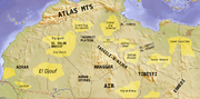
The Sahara's boundaries are the Atlantic OceanAtlantic Ocean
The Atlantic Ocean is the second-largest of the world's oceanic divisions. With a total area of about , it covers approximately 20% of the Earth's surface and about 26% of its water surface area...
on the west, the Atlas Mountains
Atlas Mountains
The Atlas Mountains is a mountain range across a northern stretch of Africa extending about through Morocco, Algeria, and Tunisia. The highest peak is Toubkal, with an elevation of in southwestern Morocco. The Atlas ranges separate the Mediterranean and Atlantic coastlines from the Sahara Desert...
and the Mediterranean Sea
Mediterranean Sea
The Mediterranean Sea is a sea connected to the Atlantic Ocean surrounded by the Mediterranean region and almost completely enclosed by land: on the north by Anatolia and Europe, on the south by North Africa, and on the east by the Levant...
on the north, the Red Sea
Red Sea
The Red Sea is a seawater inlet of the Indian Ocean, lying between Africa and Asia. The connection to the ocean is in the south through the Bab el Mandeb strait and the Gulf of Aden. In the north, there is the Sinai Peninsula, the Gulf of Aqaba, and the Gulf of Suez...
and Egypt
Egypt
Egypt , officially the Arab Republic of Egypt, Arabic: , is a country mainly in North Africa, with the Sinai Peninsula forming a land bridge in Southwest Asia. Egypt is thus a transcontinental country, and a major power in Africa, the Mediterranean Basin, the Middle East and the Muslim world...
on the east, and the Sudan
Sudan (region)
The Sudan is the name given to a geographic region to the south of the Sahara, stretching from Western to Eastern Africa. The name derives from the Arabic bilâd as-sûdân or "land of the Blacks"...
and the valley of the Niger River
Niger River
The Niger River is the principal river of western Africa, extending about . Its drainage basin is in area. Its source is in the Guinea Highlands in southeastern Guinea...
on the south. The Sahara is divided into western Sahara, the central Ahaggar Mountains
Ahaggar Mountains
The Ahaggar Mountains , also known as the Hoggar, are a highland region in central Sahara, or southern Algeria, along the Tropic of Cancer. They are located about 1,500 km south of the capital, Algiers and just west of Tamanghasset. The region is largely rocky desert with an average...
, the Tibesti Mountains
Tibesti Mountains
The Tibesti Mountains are a range of inactive volcanoes located on the northern edge of the Chad Basin in the Borkou- and Tibesti Region of northern Chad. The massif is one of the most prominent features of the Central-Sahara desert and covers an area of approximately 100,000 km². The northern...
, the Air Mountains
Aïr Mountains
The Aïr Mountains is a triangular massif, located in northern Niger, within the Sahara desert...
(a region of desert mountains and high plateaus), Ténéré
Ténéré
The Ténéré is a desert region in the south central Sahara. It comprises a vast plain of sand stretching from northeastern Niger into western Chad, occupying an area of over...
desert and the Libyan desert
Libyan Desert
The Libyan Desert covers an area of approximately 1,100,000 km2, it extends approximately 1100 km from east to west, and 1,000 km from north to south, in about the shape of a rectangle...
(the most arid region). The highest peak in the Sahara is Emi Koussi
Emi Koussi
Emi Koussi is a high pyroclastic shield volcano that lies at the south end of the Tibesti Mountains in the central Sahara of northern Chad. It is the highest mountain in Chad, and the highest in the Sahara. The volcano is one of several in the Tibesti massif, and reaches 3445 m in altitude,...
(3415 m (11,204.1 ft)) in the Tibesti Mountains in northern Chad
Chad
Chad , officially known as the Republic of Chad, is a landlocked country in Central Africa. It is bordered by Libya to the north, Sudan to the east, the Central African Republic to the south, Cameroon and Nigeria to the southwest, and Niger to the west...
.
The Sahara is the largest desert on the African continent. The southern border of the Sahara is marked by a band of semiarid savanna
Savanna
A savanna, or savannah, is a grassland ecosystem characterized by the trees being sufficiently small or widely spaced so that the canopy does not close. The open canopy allows sufficient light to reach the ground to support an unbroken herbaceous layer consisting primarily of C4 grasses.Some...
called the Sahel
Sahel
The Sahel is the ecoclimatic and biogeographic zone of transition between the Sahara desert in the North and the Sudanian Savannas in the south.It stretches across the North African continent between the Atlantic Ocean and the Red Sea....
; south of the Sahel lies Southern Sudan and the Congo River Basin. Most of the Sahara consists of rocky hamada
Hamada
A hamada is a type of desert landscape consisting of largely barren, hard, rocky plateaus, with very little sand. A hamada may sometimes also be called a reg , though this more properly refers to a stony plain rather than a highland.Hamadas exist in contrast to ergs, which are large areas of...
; ergs
Erg (landform)
An erg is a broad, flat area of desert covered with wind-swept sand with little or no vegetative cover. The term takes its name from the Arabic word ʿarq , meaning "dune field"...
(large sand dune
Dune
In physical geography, a dune is a hill of sand built by wind. Dunes occur in different forms and sizes, formed by interaction with the wind. Most kinds of dunes are longer on the windward side where the sand is pushed up the dune and have a shorter "slip face" in the lee of the wind...
s) form only a minor part.
People lived on the edge of the desert thousands of years ago since the last ice age
Ice age
An ice age or, more precisely, glacial age, is a generic geological period of long-term reduction in the temperature of the Earth's surface and atmosphere, resulting in the presence or expansion of continental ice sheets, polar ice sheets and alpine glaciers...
. The Sahara was then a much wetter place than it is today. Over 30,000 petroglyph
Petroglyph
Petroglyphs are pictogram and logogram images created by removing part of a rock surface by incising, picking, carving, and abrading. Outside North America, scholars often use terms such as "carving", "engraving", or other descriptions of the technique to refer to such images...
s of river animals such as crocodile
Crocodile
A crocodile is any species belonging to the family Crocodylidae . The term can also be used more loosely to include all extant members of the order Crocodilia: i.e...
s survive, with half found in the Tassili n'Ajjer
Tassili n'Ajjer
Tassili n'Ajjer is a mountain range in the Algerian section of the Sahara Desert. It is a vast plateau in south-east Algeria at the borders of Libya, Niger and Mali, covering an area of 72,000 sq...
in southeast Algeria
Algeria
Algeria , officially the People's Democratic Republic of Algeria , also formally referred to as the Democratic and Popular Republic of Algeria, is a country in the Maghreb region of Northwest Africa with Algiers as its capital.In terms of land area, it is the largest country in Africa and the Arab...
. Fossil
Fossil
Fossils are the preserved remains or traces of animals , plants, and other organisms from the remote past...
s of dinosaur
Dinosaur
Dinosaurs are a diverse group of animals of the clade and superorder Dinosauria. They were the dominant terrestrial vertebrates for over 160 million years, from the late Triassic period until the end of the Cretaceous , when the Cretaceous–Paleogene extinction event led to the extinction of...
s, including Afrovenator
Afrovenator
Afrovenator is a genus of megalosaurid theropod dinosaur from the mid Jurassic Period of northern Africa. It was a bipedal predator, with a mouthful of sharp teeth and three claws on each hand...
, Jobaria
Jobaria
Jobaria was a sauropod dinosaur discovered in the Sahara Desert in 1997. It was named after "Jobar", a creature of local legends, and is thought to have been about 18 metres long. It was found in the Tiourarén Formation, originally thought to represent the Hauterivian to Barremian stages of the...
and Ouranosaurus
Ouranosaurus
Ouranosaurus is an unusual genus of herbivorous iguanodont dinosaur that lived during the early Cretaceous about 110 million years ago in what is now Africa. Ouranosaurus measured about seven to eight meters long...
, have also been found here.
The modern Sahara, though, is not lush in vegetation, except in the Nile
Nile
The Nile is a major north-flowing river in North Africa, generally regarded as the longest river in the world. It is long. It runs through the ten countries of Sudan, South Sudan, Burundi, Rwanda, Democratic Republic of the Congo, Tanzania, Kenya, Ethiopia, Uganda and Egypt.The Nile has two major...
Valley, at a few oases
Oasis
In geography, an oasis or cienega is an isolated area of vegetation in a desert, typically surrounding a spring or similar water source...
, and in the northern highlands, where Mediterranean plants such as the olive
Olive
The olive , Olea europaea), is a species of a small tree in the family Oleaceae, native to the coastal areas of the eastern Mediterranean Basin as well as northern Iran at the south end of the Caspian Sea.Its fruit, also called the olive, is of major agricultural importance in the...
tree are found to grow. The region has been this way since about 3600 years ago. Then, due to a climate change, the savannah changed into the sandy desert as we know it now.
Dominant ethnicities in the Sahara are various Berber
Berber people
Berbers are the indigenous peoples of North Africa west of the Nile Valley. They are continuously distributed from the Atlantic to the Siwa oasis, in Egypt, and from the Mediterranean to the Niger River. Historically they spoke the Berber language or varieties of it, which together form a branch...
groups including Tuareg tribes, various Arab
Arab
Arab people, also known as Arabs , are a panethnicity primarily living in the Arab world, which is located in Western Asia and North Africa. They are identified as such on one or more of genealogical, linguistic, or cultural grounds, with tribal affiliations, and intra-tribal relationships playing...
ized Berber groups such as the Hassaniya
Hassaniya
Hassānīya is the variety of Arabic originally spoken by the Beni Hassān Bedouin tribes, who extended their authority over most of Mauritania and the Western Sahara between the fifteenth and seventeenth centuries. It has almost completely replaced the Berber languages spoken in this region...
-speaking Maure (Moors
Moors
The description Moors has referred to several historic and modern populations of the Maghreb region who are predominately of Berber and Arab descent. They came to conquer and rule the Iberian Peninsula for nearly 800 years. At that time they were Muslim, although earlier the people had followed...
, also known as Sahrawis), including Toubou
Toubou
The Tubu are an ethnic group that live mainly in northern Chad, but also in Libya, Niger and Sudan....
, Nubians
Nubians
The Nubians are an ethnic group originally from northern Sudan, and southern Egypt now inhabiting North Africa and some parts of East Africa....
, Zaghawa, Kanuri, Hausa
Hausa people
The Hausa are one of the largest ethnic groups in West Africa. They are a Sahelian people chiefly located in northern Nigeria and southeastern Niger, but having significant numbers living in regions of Cameroon, Ghana, Cote d'Ivoire, Chad and Sudan...
, Songhai, and Fula/Fulani
Fula people
Fula people or Fulani or Fulbe are an ethnic group spread over many countries, predominantly in West Africa, but found also in Central Africa and Sudanese North Africa...
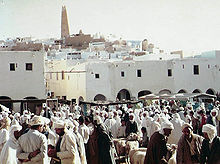
. Important cities located in the Sahara include Nouakchott
Nouakchott
-Government:The town was first divided into districts in 1973. First it was divided into four. From 1986, the city has been split into nine districts.* Arafat* Dar Naim* El Mina* Ksar* Riad* Sebkha* Tevragh-Zeina* Teyarett* Toujounine...
, the capital of Mauritania
Mauritania
Mauritania is a country in the Maghreb and West Africa. It is bordered by the Atlantic Ocean in the west, by Western Sahara in the north, by Algeria in the northeast, by Mali in the east and southeast, and by Senegal in the southwest...
; Tamanrasset, Ouargla
Ouargla
Ouargla is the capital city of Ouargla province, in the Sahara Desert, in southern Algeria. It has a flourishing oil industry, and hosts one of Algeria's universities. The city had a population of 129,402 in 1998 ....
, Bechar
Béchar
Béchar , formerly known as Colomb-Béchar, is a capital city of Béchar Province, Algeria. The area is controlled by Algeria, though claims have also been made on it by Morocco. In 1998 the city had a population of 134,954....
, Hassi Messaoud
Hassi Messaoud
Hassi Messaoud is a town in Ouargla province, southeast Algeria, north Africa. Oil was discovered there in 1956 and the town's prominence has grown rapidly since then. It is an oil refinery town named after the first oil well. A water well, dug in 1917, can be found on the airport side of town...
, Ghardaia
Ghardaïa
Ghardaïa is the capital city of Ghardaïa Province, Algeria. The commune of Ghardaïa has a population of 104,645, with 82,500 in the main city according to 2005 estimates. It is located in northern-central Algeria in the Sahara Desert and lies along the left bank of the Wadi Mzab...
, and El Oued
El Oued
El Oued or Oued Souf is a city in El Oued province, Algeria.. The oasis town is watered by an underground river, hence its name, which enables date palm cultivation and the rare use of brick construction for housing...
in Algeria; Timbuktu
Timbuktu
Timbuktu , formerly also spelled Timbuctoo, is a town in the West African nation of Mali situated north of the River Niger on the southern edge of the Sahara Desert. The town is the capital of the Timbuktu Region, one of the eight administrative regions of Mali...
in Mali
Mali
Mali , officially the Republic of Mali , is a landlocked country in Western Africa. Mali borders Algeria on the north, Niger on the east, Burkina Faso and the Côte d'Ivoire on the south, Guinea on the south-west, and Senegal and Mauritania on the west. Its size is just over 1,240,000 km² with...
; Agadez
Agadez
-Sources:* Aboubacar Adamou. "Agadez et sa région. Contribution à l'étude du Sahel et du Sahara nigériens", Études nigériennes, n°44, , 358 p.* Julien Brachet. Migrations transsahariennes. Vers un désert cosmopolite et morcelé . Paris: Le Croquant, , 324 p. ISBN : 978-2-91496865-2.*. Saudi Aaramco...
in Niger
Niger
Niger , officially named the Republic of Niger, is a landlocked country in Western Africa, named after the Niger River. It borders Nigeria and Benin to the south, Burkina Faso and Mali to the west, Algeria and Libya to the north and Chad to the east...
; Ghat in Libya
Libya
Libya is an African country in the Maghreb region of North Africa bordered by the Mediterranean Sea to the north, Egypt to the east, Sudan to the southeast, Chad and Niger to the south, and Algeria and Tunisia to the west....
; and Faya-Largeau
Faya-Largeau
Located in the Sahara, Faya's climate is classed as hot desert on the Köppen climate classification. It experiences hot winters and very hot summers with the peak average maximum temperature reaching in May and the average minimum reaching its lowest in January at . Rainfall averages out at about...
in Chad.
Geography


Algeria
Algeria , officially the People's Democratic Republic of Algeria , also formally referred to as the Democratic and Popular Republic of Algeria, is a country in the Maghreb region of Northwest Africa with Algiers as its capital.In terms of land area, it is the largest country in Africa and the Arab...
, Chad
Chad
Chad , officially known as the Republic of Chad, is a landlocked country in Central Africa. It is bordered by Libya to the north, Sudan to the east, the Central African Republic to the south, Cameroon and Nigeria to the southwest, and Niger to the west...
, Egypt
Egypt
Egypt , officially the Arab Republic of Egypt, Arabic: , is a country mainly in North Africa, with the Sinai Peninsula forming a land bridge in Southwest Asia. Egypt is thus a transcontinental country, and a major power in Africa, the Mediterranean Basin, the Middle East and the Muslim world...
, Libya
Libya
Libya is an African country in the Maghreb region of North Africa bordered by the Mediterranean Sea to the north, Egypt to the east, Sudan to the southeast, Chad and Niger to the south, and Algeria and Tunisia to the west....
, Mali
Mali
Mali , officially the Republic of Mali , is a landlocked country in Western Africa. Mali borders Algeria on the north, Niger on the east, Burkina Faso and the Côte d'Ivoire on the south, Guinea on the south-west, and Senegal and Mauritania on the west. Its size is just over 1,240,000 km² with...
, Mauritania
Mauritania
Mauritania is a country in the Maghreb and West Africa. It is bordered by the Atlantic Ocean in the west, by Western Sahara in the north, by Algeria in the northeast, by Mali in the east and southeast, and by Senegal in the southwest...
, Morocco
Morocco
Morocco , officially the Kingdom of Morocco , is a country located in North Africa. It has a population of more than 32 million and an area of 710,850 km², and also primarily administers the disputed region of the Western Sahara...
, Niger
Niger
Niger , officially named the Republic of Niger, is a landlocked country in Western Africa, named after the Niger River. It borders Nigeria and Benin to the south, Burkina Faso and Mali to the west, Algeria and Libya to the north and Chad to the east...
, Western Sahara
Western Sahara
Western Sahara is a disputed territory in North Africa, bordered by Morocco to the north, Algeria to the northeast, Mauritania to the east and south, and the Atlantic Ocean to the west. Its surface area amounts to . It is one of the most sparsely populated territories in the world, mainly...
, Sudan
Sudan
Sudan , officially the Republic of the Sudan , is a country in North Africa, sometimes considered part of the Middle East politically. It is bordered by Egypt to the north, the Red Sea to the northeast, Eritrea and Ethiopia to the east, South Sudan to the south, the Central African Republic to the...
and Tunisia
Tunisia
Tunisia , officially the Tunisian RepublicThe long name of Tunisia in other languages used in the country is: , is the northernmost country in Africa. It is a Maghreb country and is bordered by Algeria to the west, Libya to the southeast, and the Mediterranean Sea to the north and east. Its area...
. It is one of three distinct physiographic provinces of the African massive physiographic division.
The desert landforms of the Sahara are shaped by wind or by occasional rains and include sand dunes and dune fields or sand seas
Erg (landform)
An erg is a broad, flat area of desert covered with wind-swept sand with little or no vegetative cover. The term takes its name from the Arabic word ʿarq , meaning "dune field"...
(erg), stone plateaus
Hamada
A hamada is a type of desert landscape consisting of largely barren, hard, rocky plateaus, with very little sand. A hamada may sometimes also be called a reg , though this more properly refers to a stony plain rather than a highland.Hamadas exist in contrast to ergs, which are large areas of...
(hamada), gravel plains (reg), dry valleys
Wadi
Wadi is the Arabic term traditionally referring to a valley. In some cases, it may refer to a dry riverbed that contains water only during times of heavy rain or simply an intermittent stream.-Variant names:...
, and salt flats (shatt or chott). Unusual landforms include the Richat Structure
Richat Structure
The Richat Structure, also known as the Eye of the Sahara and Guelb er Richat, is a prominent circular feature in the Sahara desert of west – central Mauritania near Ouadane. This structure is a deeply eroded, slightly elliptical, 40-km in diameter, dome...
in Mauritania.
Several deeply dissected mountains and mountain ranges, many volcanic, rise from the desert, including the Aïr Mountains
Aïr Mountains
The Aïr Mountains is a triangular massif, located in northern Niger, within the Sahara desert...
, Ahaggar Mountains
Ahaggar Mountains
The Ahaggar Mountains , also known as the Hoggar, are a highland region in central Sahara, or southern Algeria, along the Tropic of Cancer. They are located about 1,500 km south of the capital, Algiers and just west of Tamanghasset. The region is largely rocky desert with an average...
, Saharan Atlas
Saharan Atlas
The Saharan Atlas of Algeria is the eastern portion of the Atlas Mountains. Not as tall as the Grand Atlas of Morocco they are far more imposing than the Tell Atlas range that runs closer to the coast. The tallest peak in the range is the high Djebel Aissa....
, Tibesti Mountains
Tibesti Mountains
The Tibesti Mountains are a range of inactive volcanoes located on the northern edge of the Chad Basin in the Borkou- and Tibesti Region of northern Chad. The massif is one of the most prominent features of the Central-Sahara desert and covers an area of approximately 100,000 km². The northern...
, Adrar des Iforas, and the Red Sea hills. The highest peak in the Sahara is Emi Koussi
Emi Koussi
Emi Koussi is a high pyroclastic shield volcano that lies at the south end of the Tibesti Mountains in the central Sahara of northern Chad. It is the highest mountain in Chad, and the highest in the Sahara. The volcano is one of several in the Tibesti massif, and reaches 3445 m in altitude,...
, a shield volcano
Shield volcano
A shield volcano is a type of volcano usually built almost entirely of fluid lava flows. They are named for their large size and low profile, resembling a warrior's shield. This is caused by the highly fluid lava they erupt, which travels farther than lava erupted from more explosive volcanoes...
in the Tibesti range of northern Chad.
Most of the rivers and streams in the Sahara are seasonal or intermittent, the chief exception being the Nile River, which crosses the desert from its origins in central Africa to empty into the Mediterranean. Underground aquifer
Aquifer
An aquifer is a wet underground layer of water-bearing permeable rock or unconsolidated materials from which groundwater can be usefully extracted using a water well. The study of water flow in aquifers and the characterization of aquifers is called hydrogeology...
s sometimes reach the surface, forming oases, including the Bahariya
Bahariya Oasis
El-Wahat el-Bahariya or el-Bahariya is a depression in Egypt. It is approximately 360 km away from Cairo. Located in Giza Governorate, the main economic sectors are agriculture, iron ore mining, and tourism...
, Ghardaïa
Ghardaïa
Ghardaïa is the capital city of Ghardaïa Province, Algeria. The commune of Ghardaïa has a population of 104,645, with 82,500 in the main city according to 2005 estimates. It is located in northern-central Algeria in the Sahara Desert and lies along the left bank of the Wadi Mzab...
, Timimoun
Timimoun
Timimoun is a little oasis town in Adrar Province, Algeria; in the Gourara region.It is located to the northwest of the eponymous Sebkha, at the edge of the plateau of Tadmaït....
, Kufrah, and Siwah.
The central part of the Sahara is hyper-arid, with little vegetation. The northern and southern reaches of the desert, along with the highlands, have areas of sparse grassland and desert shrub, with trees and taller shrubs in wadis where moisture collects.
To the north, the Sahara reaches to the Mediterranean Sea in Egypt
Egypt
Egypt , officially the Arab Republic of Egypt, Arabic: , is a country mainly in North Africa, with the Sinai Peninsula forming a land bridge in Southwest Asia. Egypt is thus a transcontinental country, and a major power in Africa, the Mediterranean Basin, the Middle East and the Muslim world...
and portions of Libya
Libya
Libya is an African country in the Maghreb region of North Africa bordered by the Mediterranean Sea to the north, Egypt to the east, Sudan to the southeast, Chad and Niger to the south, and Algeria and Tunisia to the west....
, but in Cyrenaica
Cyrenaica
Cyrenaica is the eastern coastal region of Libya.Also known as Pentapolis in antiquity, it was part of the Creta et Cyrenaica province during the Roman period, later divided in Libia Pentapolis and Libia Sicca...
and the Magreb, the Sahara borders Mediterranean forest, woodland, and scrub ecoregions of northern Africa, which have a Mediterranean climate
Mediterranean climate
A Mediterranean climate is the climate typical of most of the lands in the Mediterranean Basin, and is a particular variety of subtropical climate...
characterized by a winter rainy season. According to the botanical criteria of Frank White and geographer Robert Capot-Rey, the northern limit of the Sahara corresponds to the northern limit of Date Palm
Date Palm
The date palm is a palm in the genus Phoenix, cultivated for its edible sweet fruit. Although its place of origin is unknown because of long cultivation, it probably originated from lands around the Persian Gulf. It is a medium-sized plant, 15–25 m tall, growing singly or forming a clump with...
cultivation and the southern limit of Esparto
Esparto
Esparto, or esparto grass, also known as "halfah grass" or "needle grass", Macrochloa tenacissima and Stipa tenacissima, is a perennial grass grown in northwest Africa and the southern part of the Iberian Peninsula employed for crafts .-Esparto paper:It is also used for fiber production for paper...
, a grass typical of the Mediterranean climate portion of the Maghreb and Iberia. The northern limit also corresponds to the 100 mm (3.9 in) isohyet of annual precipitation.
To the south, the Sahara is bounded by the Sahel, a belt of dry tropical savanna with a summer rainy season that extends across Africa from east to west. The southern limit of the Sahara is indicated botanically by the southern limit of Cornulaca monacantha (a drought-tolerant member of the Chenopodiaceae
Chenopodiaceae
Chenopodiaceae were a family of flowering plants, also called the Goosefoot Family. They are now included within family Amaranthaceae. The vast majority of Chenopods are weeds, and many are salt and drought tolerant. A few food crops also belong to the family: spinach, beets, chard, quinoa, and...
), or northern limit of Cenchrus biflorus
Cenchrus biflorus
Cenchrus biflorus is a species of annual grass in the Poaceae family. Common names include Indian sandbur, Bhurat or Bhurut in India, Haskaneet in Sudan, K 'arangiya in the Hausa language of Nigeria, and Ngibbi in the Kanuri language of Nigeria...
, a grass
Poaceae
The Poaceae is a large and nearly ubiquitous family of flowering plants. Members of this family are commonly called grasses, although the term "grass" is also applied to plants that are not in the Poaceae lineage, including the rushes and sedges...
typical of the Sahel. According to climatic criteria, the southern limit of the Sahara corresponds to the 150 mm (5.9 in) isohyet of annual precipitation (this is a long-term average, since precipitation
Precipitation (meteorology)
In meteorology, precipitation In meteorology, precipitation In meteorology, precipitation (also known as one of the classes of hydrometeors, which are atmospheric water phenomena is any product of the condensation of atmospheric water vapor that falls under gravity. The main forms of precipitation...
varies annually).
Climate
The climate of the Sahara has undergone enormous variation between wet and dry over the last few hundred thousand years. During the last glacial periodGlacial period
A glacial period is an interval of time within an ice age that is marked by colder temperatures and glacier advances. Interglacials, on the other hand, are periods of warmer climate within an ice age...
, the Sahara was even bigger than it is today, extending south beyond its current boundaries. The end of the glacial period brought more rain to the Sahara, from about 8000 BC to 6000 BC, perhaps because of low pressure area
Low pressure area
A low-pressure area, or "low", is a region where the atmospheric pressure at sea level is below that of surrounding locations. Low-pressure systems form under areas of wind divergence which occur in upper levels of the troposphere. The formation process of a low-pressure area is known as...
s over the collapsing ice sheet
Ice sheet
An ice sheet is a mass of glacier ice that covers surrounding terrain and is greater than 50,000 km² , thus also known as continental glacier...
s to the north.
Once the ice sheets were gone, the northern Sahara dried out. In the southern Sahara though, the drying trend was soon counteracted by the monsoon
Monsoon
Monsoon is traditionally defined as a seasonal reversing wind accompanied by corresponding changes in precipitation, but is now used to describe seasonal changes in atmospheric circulation and precipitation associated with the asymmetric heating of land and sea...
, which brought rain further north than it does today. The monsoon season is caused by heating of air over the land during summer. The hot air rises and pulls in cool, wet air from the ocean, which causes rain. Thus, though it seems counterintuitive, the Sahara was wetter when it received more insolation
Insolation
Insolation is a measure of solar radiation energy received on a given surface area in a given time. It is commonly expressed as average irradiance in watts per square meter or kilowatt-hours per square meter per day...
in the summer. This was caused by a stronger tilt in Earth's axis of orbit
Orbital elements
Orbital elements are the parameters required to uniquely identify a specific orbit. In celestial mechanics these elements are generally considered in classical two-body systems, where a Kepler orbit is used...
than today, and perihelion
Apsis
An apsis , plural apsides , is the point of greatest or least distance of a body from one of the foci of its elliptical orbit. In modern celestial mechanics this focus is also the center of attraction, which is usually the center of mass of the system...
occurred at the end of July around 7000 BC.
By around 4200 BC, the monsoon retreated south to approximately where it is today, leading to the gradual desertification
Desertification
Desertification is the degradation of land in drylands. Caused by a variety of factors, such as climate change and human activities, desertification is one of the most significant global environmental problems.-Definitions:...
of the Sahara. The Sahara is now as dry as it was about 13,000 years ago. These conditions are responsible for what has been called the Sahara pump theory
Sahara pump theory
The Sahara pump theory is a hypothesis that explains how flora and fauna migrated between Eurasia and Africa via a Levantine land bridge. The theory observes that extended periods of abundant rainfall lasting many thousands of years in Africa are associated with a "wet Sahara" phase, during which...
.
The Sahara has one of the harshest climates in the world. The prevailing north-easterly wind often causes sand storms
Dust storm
A dust / sand storm is a meteorological phenomenon common in arid and semi-arid regions. Dust storms arise when a gust front or other strong wind blows loose sand and dirt from a dry surface. Particles are transported by saltation and suspension, causing soil to move from one place and deposition...
and dust devil
Dust devil
A dust devil is a strong, well-formed, and relatively long-lived whirlwind, ranging from small to large . The primary vertical motion is upward...
s. When this wind reaches the Mediterranean, it is known as sirocco
Sirocco
Sirocco, scirocco, , jugo or, rarely, siroc is a Mediterranean wind that comes from the Sahara and reaches hurricane speeds in North Africa and Southern Europe. It is known in North Africa by the Arabic word qibli or ghibli Sirocco, scirocco, , jugo or, rarely, siroc is a Mediterranean wind...
and often reaches hurricane speeds in North Africa and southern Europe. Half of the Sahara receives less than 20 mm (0.78740157480315 in) of rain per year, and the rest receives up to 100 mm (3.9 in) per year. The rainfall happens very rarely, but when it does it is usually torrential when it occurs after long dry periods.
The southern boundary of the Sahara, as measured by rainfall, was observed to both advance and retreat between 1980 and 1990. As a result of drought in the Sahel
Sahel drought
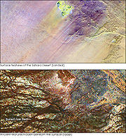
[[File:Greening Sahel 1982-1999.jpg|thumb|300px|Recent "Greening" of the Sahel: The results of trend analyses of time series over the Sahel region of seasonally integrated NDVI using NOAA AVHRR NDVI-data from 1982 to 1999...
, the southern boundary moved south 130 kilometres (80.8 mi) overall during that period.
Recent signals indicate that the Sahara and surrounding regions are greening because of increased rainfall. Satellite imaging shows extensive regreening of the Sahel between 1982 and 2002, and in both Eastern and Western Sahara a more than 20-year-long trend of increased grazing areas and flourishing trees and shrubs has been observed by climate scientist Stefan Kröpelin.
Snow and ice
On February 18, 1979, snow fell in several places in southern AlgeriaAlgeria
Algeria , officially the People's Democratic Republic of Algeria , also formally referred to as the Democratic and Popular Republic of Algeria, is a country in the Maghreb region of Northwest Africa with Algiers as its capital.In terms of land area, it is the largest country in Africa and the Arab...
, including a half-hour snowstorm that stopped traffic in Ghardaïa
Ghardaïa
Ghardaïa is the capital city of Ghardaïa Province, Algeria. The commune of Ghardaïa has a population of 104,645, with 82,500 in the main city according to 2005 estimates. It is located in northern-central Algeria in the Sahara Desert and lies along the left bank of the Wadi Mzab...
, and was reported as being "for the first time in living memory". The snow was gone within hours.
Several Saharan mountain ranges, however, receive snow on a more regular basis. Although relative humidity
Relative humidity
Relative humidity is a term used to describe the amount of water vapor in a mixture of air and water vapor. It is defined as the partial pressure of water vapor in the air-water mixture, given as a percentage of the saturated vapor pressure under those conditions...
is low in the arid environment, the absolute humidity is sufficiently high for moisture to condense
Condensation
Condensation is the change of the physical state of matter from gaseous phase into liquid phase, and is the reverse of vaporization. When the transition happens from the gaseous phase into the solid phase directly, the change is called deposition....
when driven up a mountain range. In winter, temperatures drop low enough on the Tahat summit to cause snow on average every three years; the Tibesti Mountains
Tibesti Mountains
The Tibesti Mountains are a range of inactive volcanoes located on the northern edge of the Chad Basin in the Borkou- and Tibesti Region of northern Chad. The massif is one of the most prominent features of the Central-Sahara desert and covers an area of approximately 100,000 km². The northern...
receive snow on peaks over 2500 metres (8,202.1 ft) once every seven years on average.
Ecoregions
Ecoregion
An ecoregion , sometimes called a bioregion, is an ecologically and geographically defined area that is smaller than an ecozone and larger than an ecosystem. Ecoregions cover relatively large areas of land or water, and contain characteristic, geographically distinct assemblages of natural...
s, and with their variations in temperature, rainfall, elevation, and soil, they harbor distinct communities of plants and animals.
The Atlantic coastal desert
Atlantic coastal desert
The Atlantic coastal desert is the westernmost ecoregion in the Sahara of North Africa. It occupies a narrow strip along the Atlantic coast, where fog generated offshore by the cool Canary Current provides sufficient moisture to sustain a variety of lichens, succulents, and shrubs.It covers in...
occupies a narrow strip along the Atlantic
Atlantic Ocean
The Atlantic Ocean is the second-largest of the world's oceanic divisions. With a total area of about , it covers approximately 20% of the Earth's surface and about 26% of its water surface area...
coast, where fog generated offshore by the cool Canary Current
Canary Current
The Canary Current is a wind-driven surface current that is part of the North Atlantic Gyre. This eastern boundary current branches south from the North Atlantic Current and flows southwest about as far as Senegal where it turns west and later joins the Atlantic North Equatorial Current. The...
provides sufficient moisture to sustain a variety of lichen
Lichen
Lichens are composite organisms consisting of a symbiotic organism composed of a fungus with a photosynthetic partner , usually either a green alga or cyanobacterium...
s, succulents
Succulent plant
Succulent plants, also known as succulents or fat plants, are water-retaining plants adapted to arid climates or soil conditions. Succulent plants store water in their leaves, stems, and also in roots...
, and shrubs. It covers 39900 square kilometres (15,405.5 sq mi) in Western Sahara
Western Sahara
Western Sahara is a disputed territory in North Africa, bordered by Morocco to the north, Algeria to the northeast, Mauritania to the east and south, and the Atlantic Ocean to the west. Its surface area amounts to . It is one of the most sparsely populated territories in the world, mainly...
and Mauritania
Mauritania
Mauritania is a country in the Maghreb and West Africa. It is bordered by the Atlantic Ocean in the west, by Western Sahara in the north, by Algeria in the northeast, by Mali in the east and southeast, and by Senegal in the southwest...
.
The North Saharan steppe and woodlands
North Saharan steppe and woodlands
The North Saharan steppe and woodlands is a desert ecoregion, in the Deserts and xeric shrublands biome, that forms the northern edge of the Sahara, adjacent to the Mediterranean Maghreb and Cyrenaica ecoregions of the Mediterranean forests, woodlands, and scrub Biome.Winter rains sustain...
lies along the northern desert, next to the Mediterranean forests, woodlands, and scrub
Mediterranean forests, woodlands, and scrub
Mediterranean forests, woodlands, and scrub biome, defined by the World Wildlife Fund, characterized by dry summers and rainy winters. Summers are typically hot in low-lying inland locations but can be cool near some seas, as near San Francisco, which have a sea of cool waters...
ecoregions of the northern Maghreb
Maghreb
The Maghreb is the region of Northwest Africa, west of Egypt. It includes five countries: Morocco, Algeria, Tunisia, Libya, and Mauritania and the disputed territory of Western Sahara...
and Cyrenaica
Cyrenaica
Cyrenaica is the eastern coastal region of Libya.Also known as Pentapolis in antiquity, it was part of the Creta et Cyrenaica province during the Roman period, later divided in Libia Pentapolis and Libia Sicca...
. Winter rains sustain shrublands and dry woodlands that form a transition between the Mediterranean climate
Mediterranean climate
A Mediterranean climate is the climate typical of most of the lands in the Mediterranean Basin, and is a particular variety of subtropical climate...
regions to the north and the hyper-arid Sahara proper to the south. It covers 1675300 square kilometres (646,836.9 sq mi) in Algeria
Algeria
Algeria , officially the People's Democratic Republic of Algeria , also formally referred to as the Democratic and Popular Republic of Algeria, is a country in the Maghreb region of Northwest Africa with Algiers as its capital.In terms of land area, it is the largest country in Africa and the Arab...
, Egypt
Egypt
Egypt , officially the Arab Republic of Egypt, Arabic: , is a country mainly in North Africa, with the Sinai Peninsula forming a land bridge in Southwest Asia. Egypt is thus a transcontinental country, and a major power in Africa, the Mediterranean Basin, the Middle East and the Muslim world...
, Libya
Libya
Libya is an African country in the Maghreb region of North Africa bordered by the Mediterranean Sea to the north, Egypt to the east, Sudan to the southeast, Chad and Niger to the south, and Algeria and Tunisia to the west....
, Mauritania, Morocco
Morocco
Morocco , officially the Kingdom of Morocco , is a country located in North Africa. It has a population of more than 32 million and an area of 710,850 km², and also primarily administers the disputed region of the Western Sahara...
, Tunisia
Tunisia
Tunisia , officially the Tunisian RepublicThe long name of Tunisia in other languages used in the country is: , is the northernmost country in Africa. It is a Maghreb country and is bordered by Algeria to the west, Libya to the southeast, and the Mediterranean Sea to the north and east. Its area...
, and Western Sahara.
The Sahara desert ecoregion
Sahara Desert (ecoregion)
The Sahara desert ecoregion, as defined by the World Wide Fund for Nature , includes the hyper-arid center of the Sahara, between 18° and 30° N. It is one of several desert and xeric shrubland ecoregions that cover the northern portion of the African continent.-Setting:The Sahara is the world's...
covers the hyper-arid central portion of the Sahara where rainfall is minimal and sporadic. Vegetation is rare, and this ecoregion consists mostly of sand dunes (erg, chech, raoui), stone plateaus (hamadas), gravel plains (reg), dry valleys (wadis), and salt flats. It covers 4,639,900 square km (1,791,500 square miles) of Algeria, Chad
Chad
Chad , officially known as the Republic of Chad, is a landlocked country in Central Africa. It is bordered by Libya to the north, Sudan to the east, the Central African Republic to the south, Cameroon and Nigeria to the southwest, and Niger to the west...
, Egypt, Libya, Mali
Mali
Mali , officially the Republic of Mali , is a landlocked country in Western Africa. Mali borders Algeria on the north, Niger on the east, Burkina Faso and the Côte d'Ivoire on the south, Guinea on the south-west, and Senegal and Mauritania on the west. Its size is just over 1,240,000 km² with...
, Mauritania, Niger
Niger
Niger , officially named the Republic of Niger, is a landlocked country in Western Africa, named after the Niger River. It borders Nigeria and Benin to the south, Burkina Faso and Mali to the west, Algeria and Libya to the north and Chad to the east...
, and Sudan
Sudan
Sudan , officially the Republic of the Sudan , is a country in North Africa, sometimes considered part of the Middle East politically. It is bordered by Egypt to the north, the Red Sea to the northeast, Eritrea and Ethiopia to the east, South Sudan to the south, the Central African Republic to the...
.
The South Saharan steppe and woodlands
South Saharan steppe and woodlands
The South Saharan steppe and woodlands is a deserts and xeric shrublands ecoregion of northern Africa.The ecoregion covers in Algeria, Chad, Mali, Mauritania, and Sudan...
ecoregion occupies a narrow band running east and west between the hyper-arid Sahara and the Sahel savannas to the south. Movements of the equatorial Intertropical Convergence Zone
Intertropical Convergence Zone
The Intertropical Convergence Zone , known by sailors as The Doldrums, is the area encircling the earth near the equator where winds originating in the northern and southern hemispheres come together....
(ITCZ) bring summer rains during July and August which average 100 to 200 mm (3.9 to 7.9 in) but vary greatly from year to year. These rains sustain summer pastures of grasses and herbs, with dry woodlands and shrublands along seasonal watercourses. The ecoregion covers 1,101,700 km2 (425,400 mi2) in Algeria, Chad, Mali, Mauritania, and Sudan.
In the West Saharan montane xeric woodlands
West Saharan montane xeric woodlands
The West Saharan montane xeric woodlands is an ecoregion that extends across several highland regions in the Sahara. Surrounded at lower elevations by the largely barren Sahara, the West Saharan montane xeric woodlands are isolated refuges of plants and animals that can survive in the higher...
, several volcanic highlands provide a cooler, moister environment that supports Saharo-Mediterranean woodlands and shrublands. The ecoregion covers 258,100 km2 (99,700 mi2), mostly in the Tassili n'Ajjer
Tassili n'Ajjer
Tassili n'Ajjer is a mountain range in the Algerian section of the Sahara Desert. It is a vast plateau in south-east Algeria at the borders of Libya, Niger and Mali, covering an area of 72,000 sq...
of Algeria, with smaller enclaves in the Aïr of Niger, the Dhar Adrar of Mauritania, and the Adrar des Iforas of Mali and Algeria.
The Tibesti-Jebel Uweinat montane xeric woodlands
Tibesti-Jebel Uweinat montane xeric woodlands
The Tibesti-Jebel Uweinat montane xeric woodlands ecoregion, in the deserts and xeric shrublands Biome, is located in the Maghreb of North Africa...
ecoregion consists of the Tibesti and Jebel Uweinat
Jebel Uweinat
Jebel Uweinat is a mountain range in the area of the Egyptian-Libyan-Sudanese border. The mountain lies about 40 km S-SE of Jabal Arkanu...
highlands. Higher and more regular rainfall and cooler temperatures support woodlands and shrublands of palm
Date Palm
The date palm is a palm in the genus Phoenix, cultivated for its edible sweet fruit. Although its place of origin is unknown because of long cultivation, it probably originated from lands around the Persian Gulf. It is a medium-sized plant, 15–25 m tall, growing singly or forming a clump with...
s, acacia
Acacia
Acacia is a genus of shrubs and trees belonging to the subfamily Mimosoideae of the family Fabaceae, first described in Africa by the Swedish botanist Carl Linnaeus in 1773. Many non-Australian species tend to be thorny, whereas the majority of Australian acacias are not...
s, myrtle, oleander
Oleander
Nerium oleander is an evergreen shrub or small tree in the dogbane family Apocynaceae, toxic in all its parts. It is the only species currently classified in the genus Nerium. It is most commonly known as oleander, from its superficial resemblance to the unrelated olive Olea, but has many other...
, tamarix
Tamarix
The genus Tamarix is composed of about 50-60 species of flowering plants in the family Tamaricaceae, native to drier areas of Eurasia and Africa...
, and several rare and endemic plants. The ecoregion covers 82,200 km2 (31,700 mi2) in the Tibesti of Chad and Libya, and Jebel Uweinat on the border of Egypt, Libya, and Sudan.
The Saharan halophytics is an area of seasonally flooded saline depressions which is home to halophytic, or salt-adapted, plant communities. The Saharan halophytics cover 54,000 km2 (20,800 mi2), including the Qattara
Qattara Depression
The Qattara Depression is a depression in the north west of Egypt in the Matruh Governorate and is part of the Libyan Desert. It lies below sea level and is covered with salt pans, sand dunes and salt marshes. The region extends between latitudes of 28°35' and 30°25' North and longitudes of 26°20'...
and Siwa depressions in northern Egypt, the Tunisian salt lakes
Tunisian salt lakes
The Tunisian salt lakes are a series of lakes in central Tunisia, lying south of the Atlas Mountains at the northern edge of the Sahara. The lakes include, from east to west, the Chott el Fedjedji, Chott el Djerid, and Chott el Gharsa....
of central Tunisia, Chott Melghir in Algeria, and smaller areas of Algeria, Mauritania, and Western Sahara.
The Tanezrouft
Tanezrouft
The Tanezrouft is one of the most desolate parts of the Sahara desert. It is situated along the borders among Algeria, Niger and Mali, west of the Hoggar mountains.-Geographic features:...
is one of the harshest regions on Earth and the driest in the Sahara, with no vegetation and very little life. It is situated along the borders of Algeria, Niger
Niger
Niger , officially named the Republic of Niger, is a landlocked country in Western Africa, named after the Niger River. It borders Nigeria and Benin to the south, Burkina Faso and Mali to the west, Algeria and Libya to the north and Chad to the east...
and Mali
Mali
Mali , officially the Republic of Mali , is a landlocked country in Western Africa. Mali borders Algeria on the north, Niger on the east, Burkina Faso and the Côte d'Ivoire on the south, Guinea on the south-west, and Senegal and Mauritania on the west. Its size is just over 1,240,000 km² with...
, west of the Hoggar
Ahaggar Mountains
The Ahaggar Mountains , also known as the Hoggar, are a highland region in central Sahara, or southern Algeria, along the Tropic of Cancer. They are located about 1,500 km south of the capital, Algiers and just west of Tamanghasset. The region is largely rocky desert with an average...
mountains.
Flora and fauna
DromedaryDromedary
The dromedary or Arabian camel is a large, even-toed ungulate with one hump on its back. Its native range is unclear, but it was probably the Arabian Peninsula. The domesticated form occurs widely in North Africa and the Middle East...
camels and goat
Goat
The domestic goat is a subspecies of goat domesticated from the wild goat of southwest Asia and Eastern Europe. The goat is a member of the Bovidae family and is closely related to the sheep as both are in the goat-antelope subfamily Caprinae. There are over three hundred distinct breeds of...
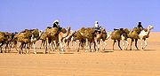
s are the domesticated animals most commonly found in the Sahara. Because of its qualities of endurance and speed, the dromedary is the favorite animal used by nomad
Nomad
Nomadic people , commonly known as itinerants in modern-day contexts, are communities of people who move from one place to another, rather than settling permanently in one location. There are an estimated 30-40 million nomads in the world. Many cultures have traditionally been nomadic, but...
s.
The deathstalker
Deathstalker
The deathstalker , is a species of scorpion, a member of the Buthidae family. It is also known as Palestine yellow scorpion, Omdurman scorpion, Israeli desert scorpion and numerous other colloquial names, which generally originate from the commercial captive trade of the animal...
scorpion can be 10 cm (3.9 in) long. Its venom contains large amounts of agitoxin
Agitoxin
Agitoxin is a toxin found in the venom of the scorpion Leiurus quinquestriatus herbraeus .Agitoxin binds to the Shaker K+ channel in Drosophila as well as to its mammalian homologue...
and scyllatoxin
Scyllatoxin
Scyllatoxin is a toxin, from the scorpion Leiurus quinquestriatus hebraeus, which blocks small-conductance Ca2+-activated K+ channels.- Source :...
and is very dangerous; however, a sting from this scorpion rarely kills a healthy adult.
Pale Fox
The pale fox , also known as the African sand fox or the pallid fox is a species of fox found in the band of African Sahel from Senegal in the west to Sudan in the east...
and Rüppell's fox
Rüppell's Fox
Rüppell's fox , also spelled Rueppell's fox and also called the sand fox, is a species of fox living in North Africa and the Middle East, from Morocco and the Sahel region to the Afghanistan hills. and SW Pakistan It is named after the German collector Eduard Rüppell...
. The addax
Addax
The Addax , also known as the screwhorn antelope, is a critically endangered species of antelope that lives in the Sahara desert. As suggested by its alternative name, this pale antelope has long, twisted horns. It is closely related to the oryx, but differs from other antelopes by having large...
, a large white antelope
Antelope
Antelope is a term referring to many even-toed ungulate species indigenous to various regions in Africa and Eurasia. Antelopes comprise a miscellaneous group within the family Bovidae, encompassing those old-world species that are neither cattle, sheep, buffalo, bison, nor goats...
, can go nearly a year in the desert without drinking. The dorcas gazelle
Dorcas Gazelle
The Dorcas Gazelle , also known as the Ariel Gazelle, is a small and common gazelle. The Dorcas Gazelle stands approximately 55-65 cm . Dorcas gazelle have a head and body length of 90-110 cm and a weight of 15-20 kg...
is a north African gazelle that can also go for a long time without water.
The Saharan cheetah
Cheetah
The cheetah is a large-sized feline inhabiting most of Africa and parts of the Middle East. The cheetah is the only extant member of the genus Acinonyx, most notable for modifications in the species' paws...
(Northwest African Cheetah
Northwest African Cheetah
The Northwest African Cheetah , also known as the Saharan Cheetah, is a subspecies of cheetah found in the northwestern part of Africa The Northwest African Cheetah (Acinonyx jubatus hecki), also known as the Saharan Cheetah, is a subspecies of cheetah found in the northwestern part of Africa The...
) lives in Algeria, Togo
Togo
Togo, officially the Togolese Republic , is a country in West Africa bordered by Ghana to the west, Benin to the east and Burkina Faso to the north. It extends south to the Gulf of Guinea, on which the capital Lomé is located. Togo covers an area of approximately with a population of approximately...
, Niger
Niger
Niger , officially named the Republic of Niger, is a landlocked country in Western Africa, named after the Niger River. It borders Nigeria and Benin to the south, Burkina Faso and Mali to the west, Algeria and Libya to the north and Chad to the east...
, Mali
Mali
Mali , officially the Republic of Mali , is a landlocked country in Western Africa. Mali borders Algeria on the north, Niger on the east, Burkina Faso and the Côte d'Ivoire on the south, Guinea on the south-west, and Senegal and Mauritania on the west. Its size is just over 1,240,000 km² with...
, Benin
Benin
Benin , officially the Republic of Benin, is a country in West Africa. It borders Togo to the west, Nigeria to the east and Burkina Faso and Niger to the north. Its small southern coastline on the Bight of Benin is where a majority of the population is located...
, and Burkina Faso
Burkina Faso
Burkina Faso – also known by its short-form name Burkina – is a landlocked country in west Africa. It is surrounded by six countries: Mali to the north, Niger to the east, Benin to the southeast, Togo and Ghana to the south, and Côte d'Ivoire to the southwest.Its size is with an estimated...
. There remain less than 250 mature cheetahs which are very cautious, fleeing any human presence. The cheetah avoids the sun from April to October. It then seeks the shelter of shrubs such as balanites and acacias. They are unusually pale.
Other animals include the monitor lizard
Monitor lizard
Monitor lizards are usually large reptiles, although some can be as small as in length. They have long necks, powerful tails and claws, and well-developed limbs. Most species are terrestrial, but arboreal and semiaquatic monitors are also known...
s, hyrax
Hyrax
A hyrax is any of four species of fairly small, thickset, herbivorous mammals in the order Hyracoidea. The rock hyrax Procavia capensis, the yellow-spotted rock hyrax Heterohyrax brucei, the western tree hyrax Dendrohyrax dorsalis, and the southern tree hyrax, Dendrohyrax arboreus live in Africa...
, Sand vipers
Cerastes (genus)
Cerastes is a genus of small, venomous vipers found in the deserts and semi-deserts of northern North Africa eastward through Arabia and Iran. Three species are currently recognized.-Description:...
, and small populations of African Wild Dog
African Wild Dog
Lycaon pictus is a large canid found only in Africa, especially in savannas and lightly wooded areas. It is variously called the African wild dog, African hunting dog, Cape hunting dog, painted dog, painted wolf, painted hunting dog, spotted dog, or ornate wolf...
, in perhaps only 14 countries. and ostrich
Ostrich
The Ostrich is one or two species of large flightless birds native to Africa, the only living member of the genus Struthio. Some analyses indicate that the Somali Ostrich may be better considered a full species apart from the Common Ostrich, but most taxonomists consider it to be a...
.
There exist other animals in the Sahara (birds in particular) such as African Silverbill
African Silverbill
The African Silverbill is a small passerine bird formerly considered conspecific with the Asian species Indian Silverbill, . This estrildid finch is a common resident breeding bird in dry savanna habitat, south of the Sahara Desert...
and Black-throated Firefinch
Black-throated Firefinch
The Black-throated Firefinch is a common species of estrildid finch found in Africa. It has an estimated global extent of occurrence of 2,100,000 km²....
among others. There are also small desert crocodile
Desert Crocodile
The desert crocodile, Northwest African crocodile, or West African crocodile is a species of crocodile distantly related to the Nile crocodile . The crocodile inhabits the Republic of Congo, Uganda, Gambia, Senegal, Mauritania, Burkina Faso, Ivory Coast, the Democratic Republic of Congo, Chad...
s in Mauritania and the Ennedi Plateau
Ennedi Plateau
The Ennedi Plateau, located in the North-East of Chad, in the Bourkou-Ennedi-Tibesti Region, is a sandstone bulwark in the middle of the Sahara. It is assailed by the sands on all sides, that encroach the deep valleys of the Ennedi...
of Chad.
The central Sahara is estimated to include five hundred species of plants, which is extremely low considering the huge extent of the area. Plants such as acacia trees, palms, succulents, spiny shrubs, and grasses have adapted to the arid conditions, by growing lower to avoid water loss by strong winds, by storing water in their thick stems to use it in dry periods, by having long roots that travel horizontally to reach the maximum area of water and to find any surface moisture and by having small thick leaves or needles to prevent water loss by evapo-transpiration. Plant leaves may dry out totally and then recover.
Human activities are more likely to affect the habitat in areas of permanent water (oases) or where water comes close to the surface. Here, the local pressure on natural resources can be intense. The remaining populations of large mammals have been greatly reduced by hunting for food and recreation.
In recent years development projects have started in the deserts of Algeria and Tunisia using irrigated water pumped from underground aquifers. These schemes often lead to soil degradation and salinization.
Berbers
The Berber peopleBerber people
Berbers are the indigenous peoples of North Africa west of the Nile Valley. They are continuously distributed from the Atlantic to the Siwa oasis, in Egypt, and from the Mediterranean to the Niger River. Historically they spoke the Berber language or varieties of it, which together form a branch...
occupied (and still occupy) much of the Sahara. The Garamantes
Garamantes
The Garamantes were a Saharan people who used an elaborate underground irrigation system, and founded a prosperous Berber kingdom in the Fezzan area of modern-day Libya, in the Sahara desert. They were a local power in the Sahara between 500 BC and 700 AD.There is little textual information about...
Berbers built a prosperous empire in the heart of the desert. The Tuareg nomads continue, to present day, to inhabit and move across wide Sahara surfaces.
Egyptians
By 6000 BC predynastic EgyptPredynastic Egypt
The Prehistory of Egypt spans the period of earliest human settlement to the beginning of the Early Dynastic Period of Egypt in ca. 3100 BC, starting with King Menes/Narmer....
ians in the southwestern corner of Egypt were herding cattle and constructing large buildings. Subsistence in organized and permanent settlements in predynastic Egypt by the middle of the 6th millennium BC centered predominantly on cereal and animal agriculture: cattle
Cattle
Cattle are the most common type of large domesticated ungulates. They are a prominent modern member of the subfamily Bovinae, are the most widespread species of the genus Bos, and are most commonly classified collectively as Bos primigenius...
, goat
Goat
The domestic goat is a subspecies of goat domesticated from the wild goat of southwest Asia and Eastern Europe. The goat is a member of the Bovidae family and is closely related to the sheep as both are in the goat-antelope subfamily Caprinae. There are over three hundred distinct breeds of...
s, pig
Pig
A pig is any of the animals in the genus Sus, within the Suidae family of even-toed ungulates. Pigs include the domestic pig, its ancestor the wild boar, and several other wild relatives...
s and sheep. Metal objects replaced prior ones of stone. Tanning of animal skins, pottery and weaving were commonplace in this era also. There are indications of seasonal or only temporary occupation of the Al Fayyum
Al Fayyum
Faiyum is a city in Middle Egypt. Located 130 km southwest of Cairo, it is the capital of the modern Faiyum Governorate. The town occupies part of the ancient site of Crocodilopolis...
in the 6th millennium BC, with food activities centering on fishing, hunting and food-gathering. Stone arrowhead
Arrowhead
An arrowhead is a tip, usually sharpened, added to an arrow to make it more deadly or to fulfill some special purpose. Historically arrowheads were made of stone and of organic materials; as human civilization progressed other materials were used...
s, knives and scrapers from the era are commonly found. Burial items included pottery, jewelry, farming and hunting equipment, and assorted foods including dried meat and fruit. Burial in desert environments appears to enhance Egyptian preservation rites, and dead were buried facing due west.
By 3400 BC, the Sahara was as dry as it is today, and it became a largely impenetrable barrier to humans, with only scattered settlements around the oases but little trade or commerce through the desert. The one major exception was the Nile Valley
Nile
The Nile is a major north-flowing river in North Africa, generally regarded as the longest river in the world. It is long. It runs through the ten countries of Sudan, South Sudan, Burundi, Rwanda, Democratic Republic of the Congo, Tanzania, Kenya, Ethiopia, Uganda and Egypt.The Nile has two major...
. The Nile, however, was impassable at several cataract
Cataracts of the Nile
The cataracts of the Nile are shallow lengths of the Nile between Aswan and Khartoum where the surface of the water is broken by many small boulders and stones protruding out of the river bed, as well as many rocky islets. Aswan is also the Southern boundary of Upper Egypt...
s, making trade and contact by boat difficult.
Nubians
During the NeolithicNeolithic
The Neolithic Age, Era, or Period, or New Stone Age, was a period in the development of human technology, beginning about 9500 BC in some parts of the Middle East, and later in other parts of the world. It is traditionally considered as the last part of the Stone Age...
, before the onset of desertification, around 9500 BC the central Sudan had been a rich environment supporting a large population ranging across what is now barren desert, like the Wadi el-Qa'ab. By the 5th millennium BC, the peoples who inhabited what is now called Nubia
Nubia
Nubia is a region along the Nile river, which is located in northern Sudan and southern Egypt.There were a number of small Nubian kingdoms throughout the Middle Ages, the last of which collapsed in 1504, when Nubia became divided between Egypt and the Sennar sultanate resulting in the Arabization...
, were full participants in the "agricultural revolution," living a settled lifestyle with domesticated plants and animals. Saharan rock art of cattle and herdsmen suggests the presence of a cattle cult like those found in Sudan and other pastoral societies in Africa today. Megaliths found at Nabta Playa
Nabta Playa
Nabta Playa was once a large basin in the Nubian Desert, located approximately 800 kilometers south of modern day Cairo or about 100 kilometers west of Abu Simbel in southern Egypt, 22° 32' north, 30° 42' east...
are overt examples of probably the world's first known Archaeoastronomy
Archaeoastronomy
Archaeoastronomy is the study of how people in the past "have understood the phenomena in the sky how they used phenomena in the sky and what role the sky played in their cultures." Clive Ruggles argues it is misleading to consider archaeoastronomy to be the study of ancient astronomy, as modern...
devices, predating Stonehenge
Stonehenge
Stonehenge is a prehistoric monument located in the English county of Wiltshire, about west of Amesbury and north of Salisbury. One of the most famous sites in the world, Stonehenge is composed of a circular setting of large standing stones set within earthworks...
by some 1,000 years. This complexity, as observed at Nabta Playa, and as expressed by different levels of authority within the society there, likely formed the basis for the structure of both the Neolithic society at Nabta and the Old Kingdom of Egypt.
Phoenicians
Further information: History of Western SaharaHistory of Western Sahara
The history of Western Sahara can be traced back to the times of Carthaginian explorer Hanno the Navigator in the 5th century BC. Though few historical records are left from that period, Western Sahara's modern history has its roots linked to some nomadic groups such as the Sanhaja group and the...
The people of Phoenicia
Phoenicia
Phoenicia , was an ancient civilization in Canaan which covered most of the western, coastal part of the Fertile Crescent. Several major Phoenician cities were built on the coastline of the Mediterranean. It was an enterprising maritime trading culture that spread across the Mediterranean from 1550...
, who flourished between 1200-800 BC, created a confederation of kingdoms across the entire Sahara to Egypt. They generally settled along the Mediterranean coast, as well as the Sahara, among the people of Ancient Libya
Ancient Libya
The Latin name Libya referred to the region west of the Nile Valley, generally corresponding to modern Northwest Africa. Climate changes affected the locations of the settlements....
, who were the ancestors of people who speak Berber languages
Berber languages
The Berber languages are a family of languages indigenous to North Africa, spoken from Siwa Oasis in Egypt to Morocco , and south to the countries of the Sahara Desert...
in North Africa and the Sahara today, including the Tuareg of the central Sahara.
Tifinagh
Tifinagh is a series of abjad and alphabetic scripts used by some Berber peoples, notably the Tuareg, to write their language.A modern derivate of the traditional script, known as Neo-Tifinagh, was introduced in the 20th century...
is still used today by Berber-speaking Tuareg camel herders of the central Sahara.
Sometime between 633 BC and 530 BC, Hanno the Navigator
Hanno the Navigator
Hanno the Navigator was a Carthaginian explorer c. 500 BC, best known for his naval exploration of the African coast...
either established or reinforced Phoenician colonies in Western Sahara
Western Sahara
Western Sahara is a disputed territory in North Africa, bordered by Morocco to the north, Algeria to the northeast, Mauritania to the east and south, and the Atlantic Ocean to the west. Its surface area amounts to . It is one of the most sparsely populated territories in the world, mainly...
, but all ancient remains have vanished with virtually no trace.
Greeks
By 500 BC, GreeksAncient Greece
Ancient Greece is a civilization belonging to a period of Greek history that lasted from the Archaic period of the 8th to 6th centuries BC to the end of antiquity. Immediately following this period was the beginning of the Early Middle Ages and the Byzantine era. Included in Ancient Greece is the...
arrived in the desert. Greek traders spread along the eastern coast of the desert, establishing trading colonies along the Red Sea
Red Sea
The Red Sea is a seawater inlet of the Indian Ocean, lying between Africa and Asia. The connection to the ocean is in the south through the Bab el Mandeb strait and the Gulf of Aden. In the north, there is the Sinai Peninsula, the Gulf of Aqaba, and the Gulf of Suez...
coast. The Carthaginians
Carthage
Carthage , implying it was a 'new Tyre') is a major urban centre that has existed for nearly 3,000 years on the Gulf of Tunis, developing from a Phoenician colony of the 1st millennium BC...
explored the Atlantic coast of the desert, but the turbulence of the waters and the lack of markets caused a lack of presence further south than modern Morocco
Morocco
Morocco , officially the Kingdom of Morocco , is a country located in North Africa. It has a population of more than 32 million and an area of 710,850 km², and also primarily administers the disputed region of the Western Sahara...
. Centralized states thus surrounded the desert on the north and east; it remained outside the control of these states. Raids from the nomadic Berber people of the desert were a constant concern of those living on the edge of the desert.
Urban civilization
Garamantes
The Garamantes were a Saharan people who used an elaborate underground irrigation system, and founded a prosperous Berber kingdom in the Fezzan area of modern-day Libya, in the Sahara desert. They were a local power in the Sahara between 500 BC and 700 AD.There is little textual information about...
, arose around 500 BC in the heart of the Sahara, in a valley that is now called the Wadi al-Ajal in Fazzan, Libya
Libya
Libya is an African country in the Maghreb region of North Africa bordered by the Mediterranean Sea to the north, Egypt to the east, Sudan to the southeast, Chad and Niger to the south, and Algeria and Tunisia to the west....
. The Garamantes achieved this development by digging tunnels far into the mountains flanking the valley to tap fossil water
Fossil water
Fossil water or paleowater is groundwater that has remained sealed in an aquifer for a long period of time. Water can rest underground in "fossil aquifers" for thousands or even millions of years...
and bring it to their fields. The Garamantes grew populous and strong, conquering their neighbors and capturing many slaves (which were put to work extending the tunnels). The ancient Greeks and the Romans
Ancient Rome
Ancient Rome was a thriving civilization that grew on the Italian Peninsula as early as the 8th century BC. Located along the Mediterranean Sea and centered on the city of Rome, it expanded to one of the largest empires in the ancient world....
knew of the Garamantes and regarded them as uncivilized nomads. However, they traded with the Garamantes, and a Roman bath has been found in the Garamantes capital of Garama. Archaeologists
Archaeology
Archaeology, or archeology , is the study of human society, primarily through the recovery and analysis of the material culture and environmental data that they have left behind, which includes artifacts, architecture, biofacts and cultural landscapes...
have found eight major towns and many other important settlements in the Garamantes territory. The Garamantes civilization eventually collapsed after they had depleted available water in the aquifer
Aquifer
An aquifer is a wet underground layer of water-bearing permeable rock or unconsolidated materials from which groundwater can be usefully extracted using a water well. The study of water flow in aquifers and the characterization of aquifers is called hydrogeology...
s and could no longer sustain the effort to extend the tunnels further into the mountains.
Trans-Saharan trade
Following the Islamic conquest of North Africa in the mid-seventh to early eighth centuries, trade across the desert intensified. The kingdoms of the Sahel, especially the Ghana EmpireGhana Empire
The Ghana Empire or Wagadou Empire was located in what is now southeastern Mauritania, and Western Mali. Complex societies had existed in the region since about 1500 BCE, and around Ghana's core region since about 300 CE...
and the Mali Empire
Mali Empire
The Mali Empire or Mandingo Empire or Manden Kurufa was a West African empire of the Mandinka from c. 1230 to c. 1600. The empire was founded by Sundiata Keita and became renowned for the wealth of its rulers, especially Mansa Musa I...
, grew rich and powerful exporting gold
Gold
Gold is a chemical element with the symbol Au and an atomic number of 79. Gold is a dense, soft, shiny, malleable and ductile metal. Pure gold has a bright yellow color and luster traditionally considered attractive, which it maintains without oxidizing in air or water. Chemically, gold is a...
and salt
Salt
In chemistry, salts are ionic compounds that result from the neutralization reaction of an acid and a base. They are composed of cations and anions so that the product is electrically neutral...
to North Africa. The emirates along the Mediterranean Sea
Mediterranean Sea
The Mediterranean Sea is a sea connected to the Atlantic Ocean surrounded by the Mediterranean region and almost completely enclosed by land: on the north by Anatolia and Europe, on the south by North Africa, and on the east by the Levant...
sent south manufactured goods and horse
Horse
The horse is one of two extant subspecies of Equus ferus, or the wild horse. It is a single-hooved mammal belonging to the taxonomic family Equidae. The horse has evolved over the past 45 to 55 million years from a small multi-toed creature into the large, single-toed animal of today...
s. From the Sahara itself, salt
Edible salt
Salt, also known as table salt, or rock salt, is a mineral that is composed primarily of sodium chloride , a chemical compound belonging to the larger class of ionic salts. It is essential for animal life in small quantities, but is harmful to animals and plants in excess...
was exported. This process turned the scattered oasis communities into trading centres and brought them under the control of the empires on the edge of the desert. A significant slave trade
Arab slave trade
The Arab slave trade was the practice of slavery in the Arab World, mainly Western Asia, North Africa, East Africa and certain parts of Europe during their period of domination by Arab leaders. The trade was focused on the slave markets of the Middle East and North Africa...
crossed the desert. It has been estimated that from the 10th to the 19th century some 6,000 to 7,000 slaves were transported north each year.

Caravel
A caravel is a small, highly maneuverable sailing ship developed in the 15th century by the Portuguese to explore along the West African coast and into the Atlantic Ocean. The lateen sails gave her speed and the capacity for sailing to windward...
allowed ships, first from Portugal
Portugal
Portugal , officially the Portuguese Republic is a country situated in southwestern Europe on the Iberian Peninsula. Portugal is the westernmost country of Europe, and is bordered by the Atlantic Ocean to the West and South and by Spain to the North and East. The Atlantic archipelagos of the...
but soon from all Western Europe, to sail around the desert and gather the resources from the source in Guinea
Guinea (region)
Guinea is a traditional name for the region of Africa that lies along the Gulf of Guinea. It stretches north through the forested tropical regions and ends at the Sahel.-History:...
. The Sahara was rapidly marginalized.
Ottoman Turkish and European imperialism
At the beginning of the 19th century, most of the northern Sahara, including most of present-day Algeria, Tunisia, Libya, and Egypt, was part of the Ottoman EmpireOttoman Empire
The Ottoman EmpireIt was usually referred to as the "Ottoman Empire", the "Turkish Empire", the "Ottoman Caliphate" or more commonly "Turkey" by its contemporaries...
. The Sahel and southern Sahara were home to several independent states.
European colonialism in the Sahara began in the 19th century. France
France
The French Republic , The French Republic , The French Republic , (commonly known as France , is a unitary semi-presidential republic in Western Europe with several overseas territories and islands located on other continents and in the Indian, Pacific, and Atlantic oceans. Metropolitan France...
conquered Algeria from the Ottomans in 1830, and French rule spread south from Algeria and eastwards from Senegal into the upper Niger
Niger River
The Niger River is the principal river of western Africa, extending about . Its drainage basin is in area. Its source is in the Guinea Highlands in southeastern Guinea...
to include present-day Algeria, Chad, Mali, Mauritania, Morocco (1912), Niger, and Tunisia (1881).
Egypt, under Muhammad Ali
Muhammad Ali of Egypt
Muhammad Ali Pasha al-Mas'ud ibn Agha was a commander in the Ottoman army, who became Wāli, and self-declared Khedive of Egypt and Sudan...
and his successors, conquered Nubia in 1820–22, founded Khartoum
Khartoum
Khartoum is the capital and largest city of Sudan and of Khartoum State. It is located at the confluence of the White Nile flowing north from Lake Victoria, and the Blue Nile flowing west from Ethiopia. The location where the two Niles meet is known as "al-Mogran"...
in 1823, and conquered Darfur
Darfur
Darfur is a region in western Sudan. An independent sultanate for several hundred years, it was incorporated into Sudan by Anglo-Egyptian forces in 1916. The region is divided into three federal states: West Darfur, South Darfur, and North Darfur...
in 1874. Egypt, including the Sudan, became a British protectorate in 1882. Egypt and Britain lost control of the Sudan from 1882 to 1898 as a result of the Mahdist War
Mahdist War
The Mahdist War was a colonial war of the late 19th century. It was fought between the Mahdist Sudanese and the Egyptian and later British forces. It has also been called the Anglo-Sudan War or the Sudanese Mahdist Revolt. The British have called their part in the conflict the Sudan Campaign...
. After its capture by British troops in 1898, the Sudan became a Anglo-Egyptian condominium
Condominium (international law)
In international law, a condominium is a political territory in or over which two or more sovereign powers formally agree to share equally dominium and exercise their rights jointly, without dividing it up into 'national' zones.Although a condominium has always been...
.
Spain
Spain
Spain , officially the Kingdom of Spain languages]] under the European Charter for Regional or Minority Languages. In each of these, Spain's official name is as follows:;;;;;;), is a country and member state of the European Union located in southwestern Europe on the Iberian Peninsula...
captured present-day Western Sahara
Western Sahara
Western Sahara is a disputed territory in North Africa, bordered by Morocco to the north, Algeria to the northeast, Mauritania to the east and south, and the Atlantic Ocean to the west. Its surface area amounts to . It is one of the most sparsely populated territories in the world, mainly...
after 1874. In 1912, Italy
Italy
Italy , officially the Italian Republic languages]] under the European Charter for Regional or Minority Languages. In each of these, Italy's official name is as follows:;;;;;;;;), is a unitary parliamentary republic in South-Central Europe. To the north it borders France, Switzerland, Austria and...
captured Libya
Libya
Libya is an African country in the Maghreb region of North Africa bordered by the Mediterranean Sea to the north, Egypt to the east, Sudan to the southeast, Chad and Niger to the south, and Algeria and Tunisia to the west....
from the Ottomans.
To promote the Roman Catholic religion in the desert, the Pope
Pope
The Pope is the Bishop of Rome, a position that makes him the leader of the worldwide Catholic Church . In the Catholic Church, the Pope is regarded as the successor of Saint Peter, the Apostle...
in 1868 appointed a delegate Apostolic of the Sahara and the Sudan; later in the 19th century his jurisdiction was reorganized into the Vicariate Apostolic of Sahara
Vicariate Apostolic of Sahara
The Vicariate Apostolic of Sahara is a former Roman Catholic missionary jurisdiction in colonial Algeria and Libya.-History:The Sahara is a vast desert of northern Africa, measuring about 932 miles from north to south and 2484 miles from east to west, and dotted with oases which are centres of...
.
Breakup of the empires and afterwards
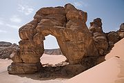
Anglo-Egyptian Treaty of 1936
The Anglo-Egyptian Treaty of 1936 was a treaty signed between the United Kingdom and the Kingdom of Egypt; it is officially known as The Treaty of Alliance Between His Majesty, in Respect of the United Kingdom, and His Majesty, the King of Egypt...
allowed Britain to keep troops in Egypt and maintained the British-Egyptian condominium in the Sudan. British military forces were withdrawn in 1954.
Most of the Saharan states achieved independence after World War II
World War II
World War II, or the Second World War , was a global conflict lasting from 1939 to 1945, involving most of the world's nations—including all of the great powers—eventually forming two opposing military alliances: the Allies and the Axis...
: Libya in 1951, Morocco, Sudan, and Tunisia in 1956, Chad, Mali, Mauritania, and Niger in 1960, and Algeria in 1962. Spain withdrew from Western Sahara in 1975, and it was partitioned between Mauritania and Morocco. Mauritania withdrew in 1979, but Morocco continues to hold the territory.
In the post-World War II era, several mines
Mining
Mining is the extraction of valuable minerals or other geological materials from the earth, from an ore body, vein or seam. The term also includes the removal of soil. Materials recovered by mining include base metals, precious metals, iron, uranium, coal, diamonds, limestone, oil shale, rock...
and communities have developed to utilize the desert's natural resources. These include large deposits of oil
Petroleum
Petroleum or crude oil is a naturally occurring, flammable liquid consisting of a complex mixture of hydrocarbons of various molecular weights and other liquid organic compounds, that are found in geologic formations beneath the Earth's surface. Petroleum is recovered mostly through oil drilling...
and natural gas
Natural gas
Natural gas is a naturally occurring gas mixture consisting primarily of methane, typically with 0–20% higher hydrocarbons . It is found associated with other hydrocarbon fuel, in coal beds, as methane clathrates, and is an important fuel source and a major feedstock for fertilizers.Most natural...
in Algeria and Libya and large deposits of phosphate
Phosphate
A phosphate, an inorganic chemical, is a salt of phosphoric acid. In organic chemistry, a phosphate, or organophosphate, is an ester of phosphoric acid. Organic phosphates are important in biochemistry and biogeochemistry or ecology. Inorganic phosphates are mined to obtain phosphorus for use in...
s in Morocco and Western Sahara.
A number of Trans-African highways
Trans-African Highway network
The Trans-African Highway network comprises transcontinental road projects in Africa being developed by the United Nations Economic Commission for Africa , the African Development Bank , and the African Union in conjunction with regional international communities...
have been proposed across the Sahara, including the Cairo-Dakar Highway
Cairo-Dakar Highway
The Cairo–Dakar Highway is Trans-African Highway 1 in the transcontinental road network being developed by the United Nations Economic Commission for Africa , the African Development Bank , and the African Union...
along the Atlantic coast, the Trans-Sahara Highway
Trans-Sahara Highway
The Trans-Sahara Highway is a transnational highway project to pave, improve and ease border formalities on an existing trade route across the Sahara Desert...
from Algiers
Algiers
' is the capital and largest city of Algeria. According to the 1998 census, the population of the city proper was 1,519,570 and that of the urban agglomeration was 2,135,630. In 2009, the population was about 3,500,000...
on the Mediterranean to Kano
Kano
Kano is a city in Nigeria and the capital of Kano State in Northern Nigeria. Its metropolitan population is the second largest in Nigeria after Lagos. The Kano Urban area covers 137 sq.km and comprises six Local Government Area - Kano Municipal, Fagge, Dala, Gwale, Tarauni and Nassarawa - with a...
in Nigeria, the Tripoli-Cape Town Highway
Tripoli-Cape Town Highway
The Tripoli – Cape Town Highway is Trans-African Highway 3 in the transcontinental road network being developed by the United Nations Economic Commission for Africa , the African Development Bank , and the African Union...
from Tripoli
Tripoli
Tripoli is the capital and largest city in Libya. It is also known as Western Tripoli , to distinguish it from Tripoli, Lebanon. It is affectionately called The Mermaid of the Mediterranean , describing its turquoise waters and its whitewashed buildings. Tripoli is a Greek name that means "Three...
in Libya to Ndjamena in Chad, and the Cairo-Cape Town Highway
Cairo-Cape Town Highway
The Cairo-Cape Town Highway is Trans-African Highway 4 in the transcontinental road network being developed by the United Nations Economic Commission for Africa , the African Development Bank , and the African Union...
which follows the Nile. Each of these highways is partially complete, with significant gaps and unpaved sections.
People and languages
Arabic is the most widely spoken language in the Sahara, from the Atlantic to the Red Sea. Berber people are found from western Egypt to Morocco, including the Tuareg pastoralists of the central Sahara. The BejaBeja people
The Beja people are an ethnic group dwelling in parts of North Africa and the Horn of Africa.-Geography:The Beja are found mostly in Sudan, but also in parts of Eritrea, and Egypt...
live in the Red Sea Hills of southeastern Egypt and eastern Sudan. The Arabic, Berber, and Beja languages are part of the Afro-Asiatic language family.
See also
- List of deserts by area
- Arid Lands Information NetworkArid Lands Information NetworkArid Lands Information Network is a Kenyan-based non-governmental organisation that seeks to exchange ideas and experiences among "grassroots change agents"...
- Sahara Conservation FundSahara Conservation FundThe Sahara Conservation Fund is an international non-governmental organization established in 2004 to conserve the wildlife of the Sahara and bordering Sahelian grasslands...
- Saharan explorersSaharan explorersSaharan explorers - a potted list.* Herodotus born c. 484 BC. Herodotus in his Histories mentions for example the Garamantes of Libya....
- Green Sahara
External links
- http://www.saudiaramcoworld.com/issue/200701/seas.beneath.the.sands.htmAbout Sahara subsurface hydrologyHydrologyHydrology is the study of the movement, distribution, and quality of water on Earth and other planets, including the hydrologic cycle, water resources and environmental watershed sustainability...
and planned usage of the aquifers]
23.079732 °N 12.612305 °W